Caprock Escarpment

Last updated
Caprock Escarpment
Caprock Escarpment Garza County Texas 2010.jpg
Caprock Escarpment, Garza County, Texas
LlanoEstacadoShadedRelief.jpg
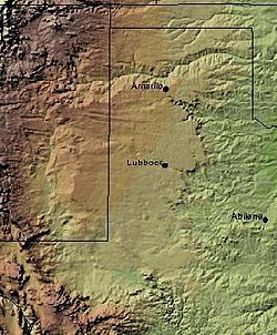
The Caprock Escarpment marking the edge of the Llano Estacado is clearly visible in this shaded relief image. The escarpment can be seen on the eastern edge of the Llano, running roughly in a north–south line through the middle of the Panhandle of Texas.
Coordinates: 34°54′35″N104°04′08″W / 34.90972°N 104.06889°W / 34.90972; -104.06889
Location New Mexico and Texas, United States
Age Quaternary
Geology Caliche
Elevation502 m (1,647 ft)
Northwest escarpment of the Llano Estacado overlooking Alamogordo Valley of Quay and Guadalupe Counties, New Mexico. Northwest Escarpment Llano Estacado 2003.jpg
Northwest escarpment of the Llano Estacado overlooking Alamogordo Valley of Quay and Guadalupe Counties, New Mexico.

The Caprock Escarpment is a term used in West Texas and Eastern New Mexico to describe the geographical transition point between the level High Plains of the Llano Estacado and the surrounding rolling terrain. [1]

Contents

In Texas, the escarpment stretches around 200 mi (320 km) south-southwest from the northeast corner of the Texas Panhandle near the Oklahoma border. The escarpment is especially notable, from north to south, in Briscoe, Floyd, Motley, Crosby, Dickens, Garza, and Borden Counties.

In New Mexico, a prominent escarpment exists along the northernmost extension of the Llano Estacado, especially to the south of San Jon and Tucumcari, both in Quay County, New Mexico. Along the western edge of the Llano Estacado, the portion of the escarpment that stretches from Caprock to Maljamar, New Mexico, is called the Mescalero Ridge. [2] [3]

Description

The escarpment is made of caliche—a layer of calcium carbonate that resists erosion. [1] In some places, the escarpment rises around 1,000 ft (300 m) above the plains to the east. The escarpment's features formed by erosion from rivers and streams, creating arroyos and highly diverse terrain, including the large Palo Duro Canyon southeast of Amarillo, Texas. [1] One will notice the change in elevation of several hundred feet while crossing the Caprock Escarpment on Interstate 40 between Adrian, Texas and San Jon, New Mexico.

The overall slight upslope, and in some areas, convergent, terrain of the Caprock is implicated in altering local weather and climate, such as enhancing precipitation and promoting thunderstorm initiation and organization. [4] [5]

Parks

Caprock Canyons State Park and Trailway, located near Quitaque, opened in 1982. A 65-mi (105-km) trail was developed within the park in 1992. Along the trail is Clarity Tunnel, home to a large colony of Mexican free-tailed bats.

See also

Related Research Articles

<span class="mw-page-title-main">Ralls, Texas</span> City in Texas, United States

Ralls is a city in Crosby County, Texas, United States. It was named after John Robinson Ralls, who, with the help of W.E. McLaughlin, laid out the townsite in July 1911. As of the 2010 census, it had a population of 1,944, down from 2,252 at the 2000 census. Ralls is surrounded by productive farmlands that primarily produce cotton and grains, with lesser amounts of soybean, sunflower seed, and vegetables.

<span class="mw-page-title-main">Palo Duro Canyon</span> Texas panhandle escarpment

Palo Duro Canyon is a canyon system of the Caprock Escarpment located in the Texas Panhandle near the cities of Amarillo and Canyon. As one of the large canyons in the United States, it is roughly 25–40 mi (40–64 km) long and has an average width of 6 mi (9.7 km), but reaches a width of 20 mi (32 km) at places. Its depth is around 800 ft (240 m), but in some locations, valley bottom to surrounding hills increases to 1,000 ft (300 m). Palo Duro Canyon has been named "The Grand Canyon of Texas" both for its size and for its dramatic geological features, including the multicolored layers of rock and steep mesa walls, which are similar to those in the Grand Canyon. It is part of Palo Duro Canyon State Park. The State Park had 442,242 visitors in 2022.

<span class="mw-page-title-main">Texas panhandle</span> Region in Texas, United States

The Texas Panhandle is a region of the U.S. state of Texas consisting of the northernmost 26 counties in the state. The panhandle is a square-shaped area bordered by New Mexico to the west and Oklahoma to the north and east. It is adjacent to the Oklahoma Panhandle, land which Texas previously claimed. The 1820 Missouri Compromise declared no slavery would be allowed in states admitted from the Louisiana Purchase above 36°30′ north latitude. Texas was annexed in 1845 from still more westerly land. The Compromise of 1850 removed territory north of this line from Texas, and set the border between the Texas Pandhandle and the New Mexico Territory at the 103rd meridian west. The eastern border at the 100th meridian west was inherited from the Adams–Onís Treaty of 1819, which defined the border between the United States and New Spain. The Handbook of Texas defines the southern border of Swisher County as the southern boundary of the Texas Panhandle region.

<span class="mw-page-title-main">Llano Estacado</span> Southwestern United States in New Mexico and Texas

The Llano Estacado, sometimes translated into English as the Staked Plains, is a region in the Southwestern United States that encompasses parts of eastern New Mexico and northwestern Texas. One of the largest mesas or tablelands on the North American continent, the elevation rises from 3,000 feet (900 m) in the southeast to over 5,000 feet (1,500 m) in the northwest, sloping almost uniformly at about 10 feet per mile (2 m/km).

<span class="mw-page-title-main">West Texas</span> Region in Texas, United States

West Texas is a loosely defined region in the U.S. state of Texas, generally encompassing the arid and semiarid lands west of a line drawn between the cities of Wichita Falls, Abilene, and Del Rio.

<span class="mw-page-title-main">Mescalero Ridge</span> Geographical transition in New Mexico and Texas, the Llano Estacados western border

The Mescalero Ridge forms the western edge of the great Llano Estacado, a vast plateau or tableland in the southwestern United States in New Mexico and Texas. It is the western equivalent of the Caprock Escarpment, which defines the eastern edge of the Llano Estacado.

<span class="mw-page-title-main">Battle of Palo Duro Canyon</span>

The Battle of Palo Duro Canyon was a military confrontation and a significant United States victory during the Red River War. The battle occurred on September 28, 1874, when several U.S. Army companies under Ranald S. Mackenzie attacked a large encampment of Plains Indians in Palo Duro Canyon in the Texas Panhandle.

<span class="mw-page-title-main">Lubbock Lake Landmark</span> Archaeological site in Texas, United States

Lubbock Lake Landmark, also known as Lubbock Lake Site, is an important archeological site and natural history preserve in the city of Lubbock, Texas, United States. The protected state and federal landmark is 336 acres (136 ha). There is evidence of ancient people and extinct animals at Lubbock Lake Landmark. It has evidence of nearly 12,000 years of use by ancient cultures on the Llano Estacado. It is part of the Museum of Texas Tech University.

<span class="mw-page-title-main">Caprock Canyons State Park and Trailway</span> Protected area in Briscoe County, Texas with 64 mile trail over former railroad right-of-way

Caprock Canyons State Park and Trailway is a Texas state park located along the eastern edge of the Llano Estacado in Briscoe County, Texas, United States, approximately 100 miles (160 km) southeast of Amarillo. The state park opened in 1982 and is 15,314 acres (6,197 ha) in size, making it the third-largest state park in Texas.

<span class="mw-page-title-main">Eastern New Mexico</span> Region in New Mexico, United States

Eastern New Mexico is a physiographic subregion within the U.S. state of New Mexico. The region is sometimes called the "High Plains," or "Eastern Plains ," and was historically referred to as part of the "Great American Desert". The region is largely coterminous with the portion of the Llano Estacado in New Mexico. Portions of Eastern New Mexico's elevation extend to over 4,000 ft (1,200 m). The region is characterized by flat, largely featureless terrain with the exception of the Pecos River valley and the abrupt breaks along the Mescalero Ridge and northern caprock escarpments of the Llano Estacado. The region typically lacks the high relief of central and northern New Mexico, such as that in the Sangre de Cristo and Sandia mountain ranges. The climate is semi-arid with hot summers and is characterized by significant wind and dust storms in the springtime.

<span class="mw-page-title-main">Geography of Texas</span> Geographical features of Texas

The geography of Texas is diverse and large. Occupying about 7% of the total water and land area of the U.S., it is the second largest state after Alaska, and is the southernmost part of the Great Plains, which end in the south against the folded Sierra Madre Oriental of Mexico. Texas is in the South Central United States of America, and is considered to form part of the U.S. South and also part of the U.S. Southwest.

<span class="mw-page-title-main">Prairie Dog Town Fork Red River</span> River in the United States

Prairie Dog Town Fork Red River is a sandy-braided stream about 120 mi (193 km) long, formed at the confluence of Palo Duro Creek and Tierra Blanca Creek, about 1.8 mi (2.9 km) northeast of Canyon in Randall County, Texas, and flowing east-southeastward to the Red River about 1 mi (2 km) east of the 100th meridian, 8 mi (13 km) south-southwest of Hollis, Oklahoma.

<span class="mw-page-title-main">Blanco Canyon</span>

Blanco Canyon is a canyon located in the U.S. state of Texas. Eroded by the White River into the Caprock Escarpment on the east side of the Llano Estacado, the canyon runs for 34 miles (55 km) in a southeasterly direction, gradually widening from its beginning in southwestern Floyd County to 10 miles (16 km) across at its mouth in southeastern Crosby County. It also gradually deepens from 50 feet (15 m) at its beginning to 300 to 500 feet at its mouth. One side canyon, 5-mile long Crawfish Canyon, was cut by Crawfish Creek as it feeds into the White River from the west.

<span class="mw-page-title-main">Mulberry Creek (Red River tributary)</span> River

Mulberry Creek is an intermittent stream about 58 mi (93 km) long, formed as a shallow draw on the high plains of the Llano Estacado in Armstrong County, Texas, and flowing southeastward to join the Prairie Dog Town Fork Red River in Hall County, Texas.

<span class="mw-page-title-main">Tierra Blanca Creek</span> River in the United States

Tierra Blanca Creek is an ephemeral stream about 75 mi (121 km) long, heading in Curry County, New Mexico, flowing east-northeast across northern portions of the Llano Estacado to join Palo Duro Creek to form the Prairie Dog Town Fork Red River southeast of Amarillo, Texas. Overall, Tierra Blanca Creek descends 1,050 ft (320 m) from its headwaters in Eastern New Mexico to its confluence with Palo Duro Creek at the head of Palo Duro Canyon.

<span class="mw-page-title-main">Yellow House Draw</span> River in the United States of America

Yellow House Draw is an ephemeral watercourse about 236 km (147 mi) long, heading about 20 km (12 mi) southwest of Melrose, New Mexico, and tending generally east-southeastward across the Llano Estacado to the city of Lubbock, where it joins Blackwater Draw to form Yellow House Canyon at the head of the North Fork Double Mountain Fork Brazos River. It stretches across Roosevelt, Curry, Bailey, Cochran, Hockley, and Lubbock Counties of eastern New Mexico and West Texas, and drains an area of 9,790 km2 (3,780 sq mi).

<span class="mw-page-title-main">Double Mountain Fork Brazos River</span> River in Texas, United States

The Double Mountain Fork Brazos River is an ephemeral, sandy-braided stream about 170 mi (280 km) long, heading on the Llano Estacado of West Texas about 11.5 mi (18.5 km) southeast of Tahoka, Texas, flowing east-northeast across the western Rolling Plains to join the Salt Fork, forming the Brazos River about 18 mi (29 km) west-northwest of Haskell, Texas.

<span class="mw-page-title-main">Salt Fork Brazos River</span> River

The Salt Fork Brazos River is a braided, highly intermittent stream about 150 mi (240 km) long, heading along the edge of the Llano Estacado about 26 mi (42 km) east-southeast of Lubbock, Texas. From its source, it flows generally east-southeastward to join the Double Mountain Fork to form the Brazos River about 18 mi (29 km) west-northwest of Haskell, Texas. The Salt Fork stretches across portions of Crosby, Garza, Kent, and Stonewall counties of West Texas.

<span class="mw-page-title-main">Little Red River (Texas)</span> River

The Little Red River is an intermittent stream about 30 mi (48 km) long, formed at the confluence of the North Prong and South Prong Little Red River in Briscoe County, Texas, and flowing east-northeastward to join the Prairie Dog Town Fork Red River in Hall County, Texas.

<span class="mw-page-title-main">McDonald Creek (Salt Fork Brazos River tributary)</span> River in the United States

McDonald Creek is an intermittent stream, about 25 mi (40 km) long, heading about 10 mi (16 km) south-southwest of Crosbyton, Texas, and trending generally southeast to join the Salt Fork Brazos River near the community of Verbena, Texas.

References

  1. 1 2 3 Carroll, H.B. "Caprock". Handbook of Texas Online. Retrieved March 1, 2013.
  2. Price, A.P. 1977. Mescalero Sandhills of Cochran and Yoakum Counties, Texas. Master's thesis, Texas Tech University, Lubbock, 253 pp.
  3. Henderson, D. 2006. An Introduction to the Mescalero Sands Ecosystem. Master's thesis, Texas A&M University, 42 pp.
  4. Walter, Kevin R.; C. C. Weiss; A. H.P. Swift (25 Oct 2005). "The Moisture Route of Palo Duro Canyon". 11th Conference on Mesoscale Processes / 32nd Conference on Radar Meteorology. Albuquerque, NM: American Meteorological Society.
  5. Marshall, Timothy P. (1980). Topographic Influences on Amarillo Radar Echo Climatology. M.S. thesis. Lubbock, TX: Texas Tech University. hdl:2346/22163.