Guadalupe County, New Mexico

Last updated

Guadalupe County
Guadalupe Courthouse New.jpg
Guadalupe County Courthouse in Santa Rosa
Map of New Mexico highlighting Guadalupe County.svg
Location within the U.S. state of New Mexico
New Mexico in United States.svg
New Mexico's location within the U.S.
Coordinates: 34°52′N104°47′W / 34.86°N 104.78°W / 34.86; -104.78
CountryFlag of the United States.svg United States
StateFlag of New Mexico.svg  New Mexico
FoundedFebruary 26, 1891
Named for Our Lady of Guadalupe
Seat Santa Rosa
Largest citySanta Rosa
Area
  Total3,032 sq mi (7,850 km2)
  Land3,030 sq mi (7,800 km2)
  Water1.1 sq mi (3 km2)  0.04%
Population
 (2020)
  Total4,452
  Density1.5/sq mi (0.57/km2)
Time zone UTC−7 (Mountain)
  Summer (DST) UTC−6 (MDT)
Congressional district 2nd
The older section of Guadalupe County Courthouse, which was built in 1909, adjoins the newer section. Guadalupe Courthouse Old.jpg
The older section of Guadalupe County Courthouse, which was built in 1909, adjoins the newer section.

Guadalupe County (Spanish : Condado de Guadalupe) is a county in the U.S. state of New Mexico. As of the 2020 census, the population was 4,452. [1] Its county seat is Santa Rosa. [2]

Contents

History

Guadalupe County was named after Nuestra Señora de Guadalupe (Our Lady of Guadalupe) or after the Mesita de Guadalupe (Guadalupe Plain). The county was created from the southern portion of San Miguel County February 26, 1891, by an act of the New Mexico Territorial Legislature. The original county seat was Puerto De Luna, but was moved north to Santa Rosa in 1903. That same year, after the popular Spanish–American War of 1898, the county's name was changed to Leonard Wood County after the Presidential physician, Major-General in the Rough Riders, and recipient of the Medal of Honor. The name was later changed back to Guadalupe County. [3] The County contains whole, or parts of, several previous Spanish land grants to include the Aqua Negra, the Jose Perea, the Anton Chico, and the Preston Beck land grants. [4]

Geography

According to the U.S. Census Bureau, the county has a total area of 3,032 square miles (7,850 km2), of which 3,030 square miles (7,800 km2) is land and 1.1 square miles (2.8 km2) (0.04%) is water. [5]

Adjacent counties

Demographics

Historical population
CensusPop.Note
1910 10,927
1920 8,015−26.6%
1930 7,027−12.3%
1940 8,64623.0%
1950 6,772−21.7%
1960 5,610−17.2%
1970 4,969−11.4%
1980 4,496−9.5%
1990 4,156−7.6%
2000 4,68012.6%
2010 4,6870.1%
2020 4,452−5.0%
U.S. Decennial Census [6]
1790–1960 [7] 1900–1990 [8]
1990–2000 [9] 2010 [10]

2000 census

As of the 2000 census, [11] there were 4,680 people, 1,655 households, and 1,145 families living in the county. The population density was 2 people per square mile (0.77 people/km2). There were 2,160 housing units at an average density of 1 units per square mile (0.39/km2). The racial makeup of the county was 54.1% White, 1.3% Black or African American, 1.1% Native American, 0.5% Asian, nil% Pacific Islander, 39.1% from other races, and 3.6% from two or more races. 81.2% of the population were Hispanic or Latino of any race.

There were 1,655 households, out of which 33.8% had children under the age of 18 living with them, 49.5% were married couples living together, 14.3% had a female householder with no husband present, and 30.8% were non-families. 27.9% of all households were made up of individuals, and 11.5% had someone living alone who was 65 years of age or older. The average household size was 2.51 and the average family size was 3.05.

In the county, the population was spread out, with 24.4% under the age of 18, 9.2% from 18 to 24, 30.7% from 25 to 44, 21.9% from 45 to 64, and 13.8% who were 65 years of age or older. The median age was 38 years. For every 100 females there were 121.5 males. For every 100 females age 18 and over, there were 126.3 males.

The median income for a household in the county was $24,783, and the median income for a family was $28,279. Males had a median income of $22,463 versus $18,500 for females. The per capita income for the county was $11,241. About 18.1% of families and 21.60% of the population were below the poverty line, including 24.1% of those under age 18 and 19.4% of those age 65 or over.

2010 census

As of the 2010 census, there were 4,687 people, 1,766 households, and 1,114 families living in the county. [12] The population density was 1.5 inhabitants per square mile (0.58 inhabitants/km2). There were 2,393 housing units at an average density of 0.8 units per square mile (0.31 units/km2). [13] The racial makeup of the county was 70.4% white, 1.9% American Indian, 1.7% black or African American, 1.3% Asian, 21.4% from other races, and 3.3% from two or more races. Those of Hispanic or Latino origin made up 79.6% of the population. [12] In terms of ancestry, 8.3% were German, and 2.4% were American. [14]

Of the 1,766 households, 30.6% had children under the age of 18 living with them, 40.9% were married couples living together, 15.2% had a female householder with no husband present, 36.9% were non-families, and 32.4% of all households were made up of individuals. The average household size was 2.33 and the average family size was 2.93. The median age was 40.1 years. [12]

The median income for a household in the county was $28,488 and the median income for a family was $37,535. Males had a median income of $36,494 versus $23,984 for females. The per capita income for the county was $13,710. About 21.7% of families and 28.2% of the population were below the poverty line, including 46.7% of those under age 18 and 27.4% of those age 65 or over. [15]

Communities

City

Town

Census-designated places

Politics

Guadalupe County leans Democratic, and has voted for that party's presidential nominee in every election since 1988.

United States presidential election results for Guadalupe County, New Mexico [16]
Year Republican Democratic Third party
No.%No.%No.%
2020 91741.89%1,23456.37%381.74%
2016 59532.57%97053.09%26214.34%
2012 55726.09%1,48869.70%904.22%
2008 62028.23%1,55770.90%190.87%
2004 91440.32%1,34059.11%130.57%
2000 54833.19%1,07665.17%271.64%
1996 43625.12%1,20869.59%925.30%
1992 69132.87%1,22558.28%1868.85%
1988 86140.63%1,24358.66%150.71%
1984 99050.36%94648.12%301.53%
1980 1,06549.65%98045.69%1004.66%
1976 1,04742.68%1,37956.22%271.10%
1972 1,29751.37%1,20247.60%261.03%
1968 1,17651.42%1,02744.91%843.67%
1964 1,05839.00%1,64960.78%60.22%
1960 1,24243.82%1,58956.07%30.11%
1956 1,52956.15%1,19143.74%30.11%
1952 1,57553.90%1,34746.10%00.00%
1948 1,56550.24%1,55049.76%00.00%
1944 1,64951.73%1,53948.27%00.00%
1940 1,80746.46%2,08253.54%00.00%
1936 1,77544.76%2,18755.14%40.10%
1932 1,62145.77%1,90953.90%120.34%
1928 1,71861.12%1,09338.88%00.00%
1924 1,32951.83%1,05641.19%1796.98%
1920 1,59956.30%1,22443.10%170.60%
1916 1,06746.90%1,17251.52%361.58%
1912 65139.17%76145.79%25015.04%

Education

The county has two school districts serving sections: Santa Rosa Consolidated Schools and Vaughn Municipal Schools. [17]

See also

Related Research Articles

<span class="mw-page-title-main">Torrance County, New Mexico</span> County in New Mexico, United States

Torrance County is a county located in the center of the U.S. state of New Mexico. As of the 2020 census, the population was 15,045. The county seat is Estancia.

<span class="mw-page-title-main">San Miguel County, New Mexico</span> County in New Mexico, United States

San Miguel County is a county in the U.S. state of New Mexico. As of the 2020 census, the population was 27,201. Its county seat is Las Vegas.

<span class="mw-page-title-main">Roosevelt County, New Mexico</span> County in New Mexico, United States

Roosevelt County is a county located in the U.S. state of New Mexico. As of the 2020 census, the population was 19,191. Its county seat is Portales. The county was created in 1903 from Chaves and Guadalupe counties and named for the then-current President of the United States, Theodore Roosevelt. The county's eastern border is the Texas state line.

<span class="mw-page-title-main">Quay County, New Mexico</span> County in New Mexico, United States

Quay County is a county in the state of New Mexico. As of the 2020 U.S. census, the population was 8,746. Its county seat is Tucumcari. The county was named for Pennsylvania senator Matthew Quay, who supported statehood for New Mexico. Its eastern border is the Texas state line, approximately 103.04 degrees west longitude.

<span class="mw-page-title-main">Lincoln County, New Mexico</span> County in New Mexico, United States

Lincoln County is a county in the U.S. state of New Mexico. As of the 2020 census, the population was 20,269. Its county seat is Carrizozo, while its largest community is Ruidoso.

<span class="mw-page-title-main">Hidalgo County, New Mexico</span> County in New Mexico, United States

Hidalgo County is the southernmost county of the U.S. state of New Mexico. As of the 2020 census, the population was 4,178. The county seat and largest city is Lordsburg. A bill creating Hidalgo from the southern part of Grant County was passed on February 25, 1919, taking effect at the beginning of 1920. The county was named for the town north of Mexico City where the Treaty of Guadalupe Hidalgo was signed, which in turn was named for Miguel Hidalgo y Costilla, the priest who is known as the "Father of Mexican Independence." The county is located on the Mexico–United States border.

<span class="mw-page-title-main">Grant County, New Mexico</span> County in New Mexico, United States

Grant County is a county located in the U.S. state of New Mexico. At the 2020 census, the population was 28,185. Its county seat is Silver City. The county was founded in 1868 and named for Ulysses S. Grant, the 18th President of the United States.

<span class="mw-page-title-main">Guadalupe, Arizona</span> Town in Maricopa County, Arizona

Guadalupe is a town in Maricopa County, Arizona, United States and part of the greater Phoenix metropolitan area. The town motto, "where three cultures flourish", recognizes the town's roots in the Yaquis, Mexicans and descendants of the original farmers. Since its founding, Guadalupe has been known as a center of Yaqui culture, and it is home to many religious festivals. Nestled between Phoenix and Tempe, the 2020 census listed the population of the town as 5,322. Guadalupe was founded around 1900 by Yaqui Indians, who fled their homeland in Sonora to avoid oppression by the Mexican government of Porfirio Díaz. The cemetery of Guadalupe was established in 1904, in the original townsite. The cemetery is now officially located in Tempe, due to that city's annexation of the land surrounding the cemetery; however, it is still administered by the Guadalupe Clerk's Office. Guadalupe is primarily a residential area; most residents commute to other parts of the Phoenix area to work.

<span class="mw-page-title-main">Urbank, Minnesota</span> City in Minnesota, United States

Urbank is a city in Otter Tail County, Minnesota, United States. The population was 52 at the 2020 census.

<span class="mw-page-title-main">Denton, Nebraska</span> Village in Nebraska, United States

Denton is a village in Lancaster County, Nebraska, United States. It is part of the Lincoln, Nebraska Metropolitan Statistical Area. The population was 189 at the 2020 census.

<span class="mw-page-title-main">Vaughn, New Mexico</span> Town in New Mexico, United States

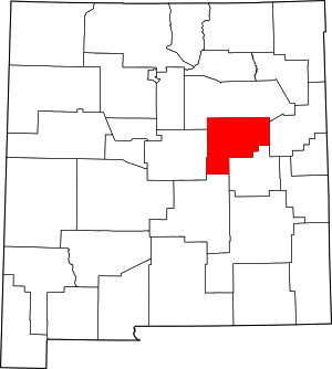
Vaughn is a town in Guadalupe County, New Mexico, United States. The population was 446 at the 2010 census, down from the figure of 539 recorded in 2000. It is located at an intersection of the Burlington Northern Santa Fe and Union Pacific railroad lines.

<span class="mw-page-title-main">Kingsbury, Texas</span> City in Texas, United States

Kingsbury is a city in eastern Guadalupe County, Texas, United States. Kingsbury was a Census-designated place in 2010, when the census reported a population of 782. It is part of the San Antonio Metropolitan Statistical Area. The election to incorporate Kingsbury into a Type-C Liberty City passed by a landslide vote of 66–2 on May 9, 2015 and the Order to declare Kingsbury a municipality was signed by County Judge Kyle Kutscher on May 19, 2015.

<span class="mw-page-title-main">McQueeney, Texas</span> Census-designated place in Texas, United States

McQueeney is an unincorporated community and census-designated place (CDP) in Guadalupe County, Texas, United States. The population was 2,545 at the 2010 census. It is part of the San Antonio Metropolitan Statistical Area.

<span class="mw-page-title-main">New Berlin, Texas</span> City in Texas, United States

New Berlin is a city in Guadalupe County, Texas, United States. The population was 511 at the 2010 census. New Berlin is a German-Texan town settled by German emigrants in the 1800s as a farming community. New Berlin is named after Berlin, Germany and boasts many residents being descendants of the original German founders.

Northcliffe is a former census-designated place (CDP) in Guadalupe County, Texas, United States. The population was 1,819 at the 2000 census. The area is now part of the city of Schertz and did not have its population recorded separately at the 2010 census. It is part of the San Antonio Metropolitan Statistical Area.

<span class="mw-page-title-main">Redwood, Texas</span> Unincorporated community in Texas, United States

Redwood is an unincorporated community and census-designated place (CDP) in Guadalupe County, Texas, United States. The population was 4,003 at the 2020 census, a decline from the figure of 4,338 tabulated in 2010. It is part of the San Antonio Metropolitan Statistical Area.

<span class="mw-page-title-main">Santa Clara, Texas</span> City in Texas, United States

Santa Clara is a city in Guadalupe County, Texas, United States. The population was 725 at the 2010 census, down from 889 at the 2000 census. It is part of the San Antonio Metropolitan Statistical Area.

<span class="mw-page-title-main">Zuehl, Texas</span> Census-designated place in Texas, United States

Zuehl is an unincorporated area and census-designated place in western Guadalupe County, Texas, United States. It is part of the San Antonio Metropolitan Statistical Area. Located on Cibolo Creek, it lies 13 miles (21 km) southwest of Seguin. The population was 362 at the 2010 census.

<span class="mw-page-title-main">Davy, West Virginia</span> Town in West Virginia, United States

Davy is a town in McDowell County, West Virginia, United States. The population was 420 at the 2010 census. Founded in 1873, the town was originally called Hallsville but the name would change to Davy by 1901. Davy was officially incorporated in 1948. It is a mostly residential community in a coal mining district along the main line of the Norfolk Southern Railway.

<span class="mw-page-title-main">De Baca County, New Mexico</span> County in New Mexico, United States

De Baca County is a county in the U.S. state of New Mexico. As of the 2020 census, the population was 1,698, making it New Mexico's second-least populous county. Its county seat is Fort Sumner. The county is named for Ezequiel Cabeza De Baca, the second elected Governor of New Mexico.

References

  1. "Guadalupe County, New Mexico". United States Census Bureau . Retrieved July 3, 2023.
  2. "Find a County". National Association of Counties. Archived from the original on May 31, 2011. Retrieved June 7, 2011.
  3. Bowden, J. J. "Guadalupe County". Office of the State Historian. Archived from the original on March 20, 2012. Retrieved December 16, 2011.
  4. "Guadalupe Co. History". The New Mexico GenWeb Project. Retrieved December 16, 2011.
  5. "2010 Census Gazetteer Files". United States Census Bureau. August 22, 2012. Archived from the original on January 1, 2015. Retrieved January 2, 2015.
  6. "U.S. Decennial Census". United States Census Bureau. Retrieved January 2, 2015.
  7. "Historical Census Browser". University of Virginia Library. Retrieved January 2, 2015.
  8. "Population of Counties by Decennial Census: 1900 to 1990". United States Census Bureau. Retrieved January 2, 2015.
  9. "Census 2000 PHC-T-4. Ranking Tables for Counties: 1990 and 2000" (PDF). United States Census Bureau. Archived (PDF) from the original on March 27, 2010. Retrieved January 2, 2015.
  10. "State & County QuickFacts". United States Census Bureau. Archived from the original on June 6, 2011. Retrieved September 29, 2013.
  11. "U.S. Census website". United States Census Bureau . Retrieved January 31, 2008.
  12. 1 2 3 "DP-1 Profile of General Population and Housing Characteristics: 2010 Demographic Profile Data". United States Census Bureau. Archived from the original on February 13, 2020. Retrieved January 24, 2016.
  13. "Population, Housing Units, Area, and Density: 2010 - County". United States Census Bureau. Archived from the original on February 13, 2020. Retrieved January 24, 2016.
  14. "DP02 Selected Social Characteristics in the United States – 2006–2010 American Community Survey 5-Year Estimates". United States Census Bureau. Archived from the original on February 13, 2020. Retrieved January 24, 2016.
  15. "DP03 Selected Economic Characteristics – 2006–2010 American Community Survey 5-Year Estimates". United States Census Bureau. Archived from the original on February 13, 2020. Retrieved January 24, 2016.
  16. Leip, David. "Dave Leip's Atlas of U.S. Presidential Elections". uselectionatlas.org. Retrieved April 1, 2018.
  17. "2020 Census – School District Reference Map:" (PDF). U.S. Census Bureau. Archived (PDF) from the original on September 4, 2022. Retrieved September 1, 2022. - Text list

34°52′N104°47′W / 34.86°N 104.78°W / 34.86; -104.78