Socorro County, New Mexico

Last updated

Socorro County
Socorro County New Mexico Court House.jpg
Socorro County Courthouse in Socorro
Map of New Mexico highlighting Socorro County.svg
Location within the U.S. state of New Mexico
New Mexico in United States.svg
New Mexico's location within the U.S.
Coordinates: 34°01′N106°56′W / 34.02°N 106.93°W / 34.02; -106.93
CountryFlag of the United States.svg United States
StateFlag of New Mexico.svg  New Mexico
FoundedJanuary 9, 1852
Seat Socorro
Largest citySocorro
Area
  Total6,649 sq mi (17,220 km2)
  Land6,647 sq mi (17,220 km2)
  Water2.1 sq mi (5 km2)  0.03%
Population
 (2020)
  Total16,595
  Density2.5/sq mi (0.96/km2)
Time zone UTC−7 (Mountain)
  Summer (DST) UTC−6 (MDT)
Congressional district 2nd
Website www.socorrocounty.net
The view from the southern San Mateo Mountains in Socorro County, New Mexico. San Mateo Mtns South.jpg
The view from the southern San Mateo Mountains in Socorro County, New Mexico.
The Karl G. Jansky Very Large Array in Socorro County. Karl G. Jansky Very Large Array (8279314499).jpg
The Karl G. Jansky Very Large Array in Socorro County.

Socorro County (Spanish : Condado de Socorro) is a county in the U.S. state of New Mexico. As of the 2020 census, the population was 16,595. [1] The county seat is Socorro. [2] The county was formed in 1852 as one of the original nine counties of New Mexico Territory. [3] [4] Socorro was originally the name given to a Native American village (see: Puebloan peoples) by Don Juan de Oñate in 1598. Having received vitally needed food and assistance from the native population, Oñate named the pueblo Socorro ("succor" in English).

Contents

Socorro County is home to multiple scientific research institutions including New Mexico Institute of Mining and Technology, the National Radio Astronomy Observatory and its associated Very Large Array, the Magdalena Ridge Observatory, and the Langmuir Laboratory for Atmospheric Research. Federal public lands in Socorro County include parts of the Cibola National Forest, the Bosque del Apache National Wildlife Refuge, the Sevilleta National Wildlife Refuge, the Bureau of Land Management (BLM) Socorro Field Office, parts of the Salinas Pueblo Missions National Monument, and parts of the El Camino Real de Tierra Adentro National Historic Trail.

History

Socorro County's history is intimately linked with the rich history of the surrounding area. Basham noted in his report documenting the archeological history of the Cibola National Forest's Magdalena Ranger District, which is almost entirely within Socorro County, that “[t]he heritage resources on the district are diverse and representative of nearly every prominent human evolutionary event known to anthropology. Evidence for human use of district lands date back 14,000 years to the Paleoindian period providing glimpses into the peopling of the New World and megafaunal extinction.“ [5] Much of the now Magdalena Ranger District were a province of the Apache. Bands of Apache effectively controlled the Magdalena-Datil region from the seventeenth century until they were defeated in the Apache Wars in the late nineteenth century. [5]

Outlaw renegades Butch Cassidy and the Wild Bunch and notorious Apaches like Cochise and Geronimo have ties to Socorro County's San Mateo Mountains. Vicks Peak was named after Victorio, “a Mimbreño Apache leader whose territory included much of the south and southwest New Mexico.” [6] Famous for defying relocation orders in 1879 and leading his warriors “on a two-year reign of terror before he was killed,” Victorio is at least as highly regarded as Geronimo or Cochise among Apaches. [6] Perhaps most famous outlaw was the Apache Kid whose supposed grave lies within the Apache Kid Wilderness. Stories of depredations by the Apache Kid, and of his demise, became so common and dramatic that in southwestern folklore they may be exceeded only by tales of lost Spanish gold. [5] Native Americans lingered in the San Mateos well into the 1900s. We know this by an essay written by Aldo Leopold in 1919 where he documents stumbling upon the remains of a recently abandoned Indian hunting camp. [7]

A mining rush followed the Apache wars – gold, silver, and copper were found in the mountains. It wasn't until this time that extensive use of the area by non-Native Americans occurred. [8] While some mining activity, involving gold, silver, and copper, occurred in the southern part of the range near the end of the nineteenth century, [9] the prospecting/mining remnants are barely visible today due to collapse, topographic screening, and vegetation regrowth. While miners combed the mountains for mineral riches during the late nineteenth and early twentieth centuries, stockmen drove tens of thousands of sheep and cattle to stockyards at the village of Magdalena, then linked by rail with Socorro. [6] In fact, the last regularly used cattle trail in the United States stretched 125 miles westward from Magdalena. The route was formally known as the Magdalena Livestock Driveway, but more popularly known to cowboys and cattlemen as the Beefsteak Trail. The trail began use in 1865 and its peak was in 1919. The trail was used continually until trailing gave way to trucking and the trail officially closed in 1971. [5]

Geography

According to the U.S. Census Bureau, the county has a total area of 6,649 square miles (17,220 km2), of which 6,647 square miles (17,220 km2) is land and 2.1 square miles (5.4 km2) (0.03%) is water. [10] It is the second-largest county in New Mexico by area, after Catron County.

Socorro County ranges in elevation from approximately 4,528 ft (1,380 m) on the banks of the Rio Grande to 10,784 ft (3,287 m) at the top of South Baldy peak in the Magdalena Mountains. The southern portion of the Rocky Mountains extend into New Mexico and Socorro County. There are several mountain ranges that spread throughout the county. The Forest Service manages portions of four mountain ranges: the Bear, Datil, Magdalena, and San Mateo Mountains. Most of the land that comprises these mountains are within the Cibola National Forest. These ranges, as well as Ladron Peak located in Socorro County, are classified as sky islands.

Adjacent counties

National protected areas

Demographics

Historical population
CensusPop.Note
1910 14,761
1920 14,061−4.7%
1930 9,611−31.6%
1940 11,42218.8%
1950 9,670−15.3%
1960 10,1685.1%
1970 9,763−4.0%
1980 12,56628.7%
1990 14,76417.5%
2000 18,07822.4%
2010 17,866−1.2%
2020 16,595−7.1%
U.S. Decennial Census [11]
1790-1960 [12] 1900–1990 [13]
1990-2000 [14] 2010 [15]

2000 census

As of the 2000 census, [16] there were 18,078 people, 6,675 households, and 4,492 families residing in the county. The population density was 3 people per square mile (1.2 people/km2). There were 7,808 housing units at an average density of 1 per square mile (0.39/km2). The racial makeup of the county was 62.9% White, 0.6% Black or African American, 10.9% Native American, 1.1% Asian, 0.1% Pacific Islander, 20.1% from other races, and 4.3% from two or more races. 48.7% of the population were Hispanic or Latino of any race.

There were 6,675 households, out of which 33.8% had children under the age of 18 living with them, 48.4% were married couples living together, 13.3% had a female householder with no husband present, and 32.7% were non-families. 26.8% of all households were made up of individuals, and 8.2% had someone living alone who was 65 years of age or older. The average household size was 2.62 and the average family size was 3.20.

In the county, the population was spread out, with 28.4% under the age of 18, 12.6% from 18 to 24, 26.1% from 25 to 44, 22.0% from 45 to 64, and 10.9% who were 65 years of age or older. The median age was 32 years. For every 100 females there were 103.3 males. For every 100 females age 18 and over, there were 103.9 males.

The median income for a household in the county was $23,439, and the median income for a family was $29,544. Males had a median income of $28,490 versus $22,482 for females. The per capita income for the county was $12,826. About 24.1% of families and 31.7% of the population were below the poverty line, including 43.6% of those under age 18 and 24.3% of those age 65 or over.

2010 census

As of the 2010 census, there were 17,866 people, 7,014 households, and 4,349 families residing in the county. [17] The population density was 2.7 inhabitants per square mile (1.0/km2). There were 8,059 housing units at an average density of 1.2 per square mile (0.46/km2). [18] The racial makeup of the county was 75.1% white, 11.7% American Indian, 1.2% Asian, 1.1% black or African American, 8.1% from other races, and 2.8% from two or more races. Those of Hispanic or Latino origin made up 48.5% of the population. [17] In terms of ancestry, 7.1% were English, 6.8% were German, and 4.2% were American. [19]

Of the 7,014 households, 30.4% had children under the age of 18 living with them, 43.1% were married couples living together, 12.9% had a female householder with no husband present, 38.% were non-families, and 30.8% of all households were made up of individuals. The average household size was 2.46 and the average family size was 3.09. The median age was 36.9 years. [17]

The median income for a household in the county was $33,284 and the median income for a family was $41,964. Males had a median income of $40,295 versus $27,819 for females. The per capita income for the county was $17,801. About 22.7% of families and 26.8% of the population were below the poverty line, including 33.1% of those under age 18 and 19.0% of those age 65 or over. [20]

Politics

The majority (51 percent) of voters registered in the 2012 General Election were Democrats, with the rest of registered voters breaking down as 30 percent Republican, 15 percent Declined To Say, and 3 percent Other. [21] In 2012, Socorro County voted for President Obama 56 percent to 38 percent, [22] with a trend of voting Democratic in the previous five presidential elections.

United States presidential election results for Socorro County, New Mexico [23]
Year Republican Democratic Third party
No.%No.%No.%
2020 3,25545.46%3,72251.98%1832.56%
2016 2,61638.09%3,31348.24%93913.67%
2012 2,72237.84%4,05856.42%4135.74%
2008 3,03238.40%4,69659.48%1672.12%
2004 3,69647.08%4,02551.27%1301.66%
2000 3,17346.48%3,29448.26%3595.26%
1996 2,31536.38%3,37453.02%67510.61%
1992 2,18635.91%2,90847.77%99416.33%
1988 3,11450.09%2,96047.61%1432.30%
1984 3,40356.27%2,54142.01%1041.72%
1980 2,68549.52%2,22641.05%5119.42%
1976 2,26545.86%2,60652.76%681.38%
1972 2,65856.19%1,99442.16%781.65%
1968 2,23052.07%1,87143.68%1824.25%
1964 1,77442.43%2,39757.33%100.24%
1960 1,79643.51%2,32756.37%50.12%
1956 2,36561.57%1,47638.43%00.00%
1952 2,22455.52%1,77744.36%50.12%
1948 2,13956.32%1,65043.44%90.24%
1944 2,03050.75%1,96749.18%30.08%
1940 2,70352.01%2,48947.89%50.10%
1936 2,53050.37%2,47749.31%160.32%
1932 1,93143.51%2,49556.22%120.27%
1928 1,94055.32%1,56444.60%30.09%
1924 2,33262.32%1,25133.43%1594.25%
1920 3,15063.16%1,80736.23%300.60%
1916 1,95455.29%1,55844.09%220.62%
1912 96041.25%1,07846.33%28912.42%

Socorro County voted for Senator Heinrich (D) 53 percent to 43 percent in 2012. While Rep. Pearce (R) won Socorro County 52 percent to 48 percent in 2012, Socorro supported Democrats for the U.S. House in both 2008 and 2010 (with 50.2% and 63% Democratic, respectively). [24] The County supported Governor Martinez (R) 53 percent to 47 percent in 2010 but went for Governor Richardson (D) in both 2002 [25] and 2006. [26] Socorro has supported Democratic state senators in Districts 28 and 30 for every election since 2000. In contrast, the county has supported a Republican state representative in District 49 since 2000. The current county commissioners of Socorro County are:

Ravi Bhasker has been serving as the mayor of Socorro since 1990 and is a general practice medical doctor. [27] The current mayor of Magdalena is Richard Rumpf (ZW), elected by the village board upon the previous mayor's resignation in 2016.

Socorro County backed Democratic gubernatorial nominee Michelle Lujan Grisham in 2018 by 57.4%, defeating Republican Steve Pearce by nearly 15 points in the county. However, in 2022, Republicans rebounded considerably and Grisham lost Socorro county to Republican Mark Ronchetti, by a margin of just 38 votes (2,988 votes to 2,950 respectively). [1] It was the only county in the state to flip Republican that year, even as Grisham handedly won re-election statewide.

Ecology, recreation and tourism

Bosque del Apache at night.jpg
Sandhill cranes sleep under a starry sky at Bosque del Apache National Wildlife Refuge.

With multiple mountain ranges, extents of grasslands and marshes providing a wide array of available habitats, Socorro County is home to an extensive variety of ecosystems and wildlife. Socorro County contains 826 species of wildlife, including 14 amphibians, 60 reptiles, 336 birds, and 96 mammals. [28] Wildlife in the County includes coyote, deer, elk, pronghorn antelope, bighorn sheep, Barbary sheep, black bear, mountain lion, wild turkey, various furbearers, Mexican spotted owl, and quail.

There are three congressionally designated Wilderness areas located within Socorro County. The Apache Kid and the Withington Wilderness Areas are both located in the San Mateo Mountains within the Cibola National Forest's Magdalena Ranger District. The Bosque del Apache Wilderness comprises two separate sections, totaling 30,427 acres of the National Wildlife Refuge. There are an additional 172,143 acres of Forest Service Inventoried Roadless Areas and 159,891 acres of BLM Wilderness Study Areas in the county. These undeveloped lands without roads offer outstanding opportunities to experience the area's amazing natural heritage, to getaway and enjoy the outdoors and, for the hearty, to explore deep into the backcountry and challenge yourself in the area's big wild.

The high mountains, remote canyons, pristine forests and diverse wildlife found on the area's national forests, national wildlife refuges, national monuments, and BLM's national system of public lands provide for phenomenal recreation opportunities, including picnicking, hiking, backpacking, wildlife viewing, horseback-riding, and hunting. In fact, the four biggest elk in New Mexico were bagged in Socorro county and the Datil Mountains. [29] The two most popular recreational activities on the Cibola National Forest are hiking/walking and viewing natural features with 35% and 15% of visitors citing these as their main activities, respectively. [30] The Bosque del Apache National Wildlife Refuge hosts the Festival of the Cranes every November, celebrating the arrival of sandhill cranes and other migratory birds. [31] Rare whooping cranes are also found occasionally on the Bosque del Apache.

The natural amenities in Socorro contribute to a strong tourism industry for the county. Visitors spent $47.4 million in Socorro County in 2011. Recreation alone accounted for more than $4 million in visitor spending in both 2010 and 2011. [32] Tourism accounts for 8.8% of employment and 4.5% of labor income for the county. Additionally, tourism resulted in $7.7 million of total tax revenue, including $1.1 million in local tax revenue. [33]

Communities

Fluorite from the Blanchard mine, near Bingham, New Mexico Fluorite-23807.jpg
Fluorite from the Blanchard mine, near Bingham, New Mexico

City

Village

Census-designated places

Unincorporated communities

Populated Places

Ghost towns

Education

School districts include: [34]

See also

Related Research Articles

<span class="mw-page-title-main">Mohave County, Arizona</span> County in Arizona, United States

Mohave County is in the northwestern corner of the U.S. state of Arizona. As of the 2020 census, its population was 213,267. The county seat is Kingman, and the largest city is Lake Havasu City. It is the fifth largest county in the United States.

<span class="mw-page-title-main">Valencia County, New Mexico</span> County in New Mexico, United States

Valencia County is a county in the U.S. state of New Mexico. As of the 2020 census, the population was 76,205. The county seat is Los Lunas.

<span class="mw-page-title-main">Cibola County, New Mexico</span> County in New Mexico, United States

Cibola County is a county in the U.S. state of New Mexico. As of the 2020 census, the population was 27,172. Its county seat is Grants. It is New Mexico's youngest county, and the third youngest county in the United States, created on June 19, 1981, from the westernmost four-fifths of the formerly much larger Valencia County.

<span class="mw-page-title-main">Catron County, New Mexico</span> County in New Mexico, United States

Catron County is a county in the U.S. state of New Mexico. As of the 2020 census, the population was 3,579, making it New Mexico's third-least populous county. Its county seat is Reserve. Catron County is New Mexico's largest county by area.

<span class="mw-page-title-main">Socorro, New Mexico</span> City in New Mexico, United States

Socorro is a city in Socorro County in the U.S. state of New Mexico. It is in the Rio Grande Valley at an elevation of 4,579 feet (1,396 m). In 2010 the population was 9,051. It is the county seat of Socorro County. Socorro is located 74 miles (119 km) south of Albuquerque and 146 miles (235 km) north of Las Cruces.

<span class="mw-page-title-main">San Antonio, New Mexico</span>

San Antonio is a census-designated place in Socorro County, New Mexico, United States, roughly in the center of the state, on the Rio Grande. The entire population of the county is approximately 18,000.

<span class="mw-page-title-main">Bosque del Apache National Wildlife Refuge</span> Wildlife refuge in New Mexico, USA

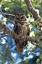
The Bosque del Apache National Wildlife Refuge is located in southern New Mexico. It was founded in 1939 and is administered by the U.S. Fish and Wildlife Service. The Piro people lived in the lands around what is now the refuge until the 1600s, when they were forced to abandon their pueblos due to European diseases and attacks from the Apache tribes. It is a favorite spot to watch the migration of the sandhill cranes in the fall. The reserve is open year-round and provides safe harbor for its varied wildlife. Visitors to the refuge also enjoy partaking in activites such as hiking, cycling, driving tours on the 12-mile scenic auto route, and participating in educational programs offered at the park.

State Road 1 (NM 1) is a state highway in New Mexico, that runs north from Mitchell Point to Socorro. Mostly paralleling Interstate 25 (I-25) throughout its entire length, it has a total length of 61.269 miles (98.603 km), and is maintained by the New Mexico Department of Transportation (NMDOT).

<span class="mw-page-title-main">Cibola National Forest</span> United States National Forest in New Mexico

The Cibola National Forest is a 1,633,783 acre United States National Forest in New Mexico, US. The name Cibola is thought to be the original Zuni Indian name for their pueblos or tribal lands. The name was later interpreted by the Spanish to mean "buffalo." The forest is disjointed with lands spread across central and northern New Mexico, west Texas and Oklahoma. The Cibola National Forest is divided into four Ranger Districts: the Sandia, Mountainair, Mt. Taylor, and Magdalena. The Forest includes the San Mateo, Magdalena, Datil, Bear, Gallina, Manzano, Sandia, Mt. Taylor, and Zuni Mountains of west-central New Mexico. The Forest also manages four National Grasslands that stretch from northeastern New Mexico eastward into the Texas Panhandle and western Oklahoma. The Cibola National Forest and Grassland is administered by Region 3 of the United States Forest Service from offices in Albuquerque, New Mexico. Elevation ranges from 5,000 ft to 11,301 ft. The descending order of Cibola National Forest acres by county are: Socorro, Cibola, McKinley, Catron, Torrance, Bernalillo, Sandoval County, New Mexico, Lincoln, Sierra, and Valencia counties in New Mexico. The Cibola National Forest currently has 137,701 acres designated as Wilderness. In addition to these acres, it has 246,000 acres classified as Inventoried Roadless Areas pursuant to the Roadless Area Conservation Rule.

Southwestern New Mexico is a region of the U.S. state of New Mexico commonly defined by Hidalgo County, Grant County, Catron County, Luna County, Doña Ana County, Sierra County, and Socorro County. Some important towns there are Lordsburg, Silver City, Deming, Las Cruces, Truth or Consequences, Socorro, Reserve, and Rodeo. Natural attractions there include White Sands National Park, the Organ Mountains, Bosque del Apache National Wildlife Refuge, and the Gila Wilderness surrounding the Gila Cliff Dwellings National Monument. Southwestern New Mexico is also home to both the Very Large Array and White Sands Missile Range containing the Trinity Site.

<span class="mw-page-title-main">Magdalena Mountains</span>

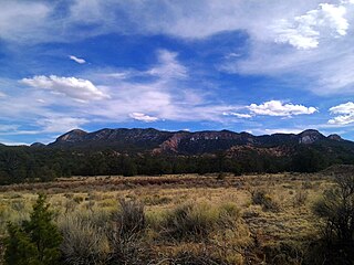
The Magdalena Mountains are a regionally high, mountain range in Socorro County, in west-central New Mexico in the southwestern United States. The highest point in the range is South Baldy, at 10,783 ft, which is also the tallest peak in Socorro County. The range runs roughly north–south and is about 18 miles (28 km) long. The range lies just south of the village of Magdalena, and about 18 miles (28 km) west of Socorro. The Magdalena Mountains are an east-tilted fault-block range, superimposed on Cenozoic calderas. The complex geologic history of the range has resulted in spectacular scenery, with unusual and eye-catching rock formations. They form part of the western edge of the Rio Grande Rift Valley, fronting the La Jencia Basin. The mountains remain isolated and natural due to the absence of any significant human development within or near the range.

<span class="mw-page-title-main">San Mateo Mountains (Socorro County, New Mexico)</span> Landscape and mass

The San Mateo Mountains are a mountain range in Socorro County, in west-central New Mexico in the southwestern United States. The highest point in the range is West Blue Mountain, at 10,336 ft. The range runs roughly north–south and is about 40 miles (64 km) long. It lies about 25 miles (40 km) north-northwest of the town of Truth or Consequences and about 30 miles (48 km) southwest of Socorro. They should not be confused with the identically named range in Cibola and McKinley counties, north of this range.

<span class="mw-page-title-main">Apache Kid Wilderness</span> Protected wilderness area in New Mexico, United States

Apache Kid Wilderness is a 44,626-acre (18,060 ha) Wilderness area located within the Magdalena Ranger District of the Cibola National Forest in the state of New Mexico. Straddling a southern portion of the San Mateo Mountains of southwestern Socorro County, the area is characterized by rugged, narrow, and steep canyons bisecting high mountain peaks exceeding 10,000 feet (3,000 m). The highest peak is West Blue Mountain which reaches an elevation of 3,151 metres (10,338 ft).

<span class="mw-page-title-main">Geography of New Mexico</span> Overview of the Geography of New Mexico

With a total area of 121,590 square miles (314,900 km2), New Mexico is the fifth-largest state, after Alaska, Texas, California, and Montana. Its eastern border lies along 103°W longitude with the state of Oklahoma, and 2.2 miles west of 103°W longitude with Texas. On the southern border, Texas makes up the eastern two-thirds, while the Mexican states of Chihuahua and Sonora make up the western third, with Chihuahua making up about 90% of that. The western border with Arizona runs along the 109° 03'W longitude. The southwestern corner of the state is known as the Bootheel. The 37°N parallel forms the northern boundary with Colorado. The states of New Mexico, Colorado, Arizona, and Utah come together at the Four Corners in New Mexico's northwestern corner. Its surface water area is about 292 square miles (760 km2).

<span class="mw-page-title-main">Rio Grande Trail</span> Proposed trail in New Mexico, United States

The Rio Grande Trail is a proposed long distance trail along the Rio Grande in the U.S. state of New Mexico. The river extends over 1,800 total miles, some 700 miles (1,100 km) of which pass through the heart of New Mexico. It is the state's primary drainage feature and most valuable natural and cultural resource. The river and its bosque provide a wide variety of recreation, including hunting and fishing, birdwatching, river rafting, hiking, biking, and horseback riding. The river also flows through or beside numerous spectacular and geologically interesting landforms, the result of extensive volcanism and erosion of the valley within the Rio Grande Rift. Although some trail advocates would like to see the trail extended the full distance through New Mexico, from the Colorado border to the United States–Mexico border, the portion proposed for initial development extends 300 miles (480 km), from Bernalillo south to Las Cruces.

<span class="mw-page-title-main">Datil Mountains</span>

The Datil Mountains are a small range on the northern edge of the Mogollon-Datil volcanic field, just northwest of the Plains of San Agustin in the U.S. state of New Mexico. The range lies in Socorro and Catron Counties, north of the town of Datil, New Mexico and takes its name from the Spanish word for “date,” dating back over two hundred years. In The Place Names of New Mexico, Robert Julyan suggests two possible explanations for the name: 1) that “the seedpods of the broad-leafed yucca sufficiently resembled dates” or 2) “the Spanish applied the name to the fruit of the prickly pear cactus.” The area includes the major ridgeline of Madre Mountain, which is sacred ground to the Acoma, Laguna, and Zuni tribes, as well as several other unnamed peaks and ridges.

<span class="mw-page-title-main">Bear Mountains</span>

The Bear Mountains lie just north of the village of Magdalena and north of the Magdalena Mountains in New Mexico. The Bear Mountains are located within the Magdalena Ranger District of the Cibola National Forest. There are two Inventoried Roadless Areas (IRA) within the Bear Mountains: the Scott Mesa IRA and the Goat Spring IRA. The Bureau of Land Management’s Sierra Ladrones Wilderness Study Area stretches to the northeast of the Bear Mountains and connects the Bear Mountains with the 230,000-acre Sevilleta National Wildlife Refuge to the east. The world-renowned Very Large Array lies to the southwest of the Bear Mountains.

<span class="mw-page-title-main">Withington Wilderness</span>

The Withington Wilderness is a 19,000-acre designated Wilderness area located within the Cibola National Forest in western New Mexico. Located in the Magdalena Ranger District, approximately 20 miles southwest of Magdalena, New Mexico, the wilderness area lies around 10,100 ft. Mount Withington, on the eastern slope of the San Mateo Mountains in Socorro County, New Mexico, United States.

<span class="mw-page-title-main">Bosque del Apache Wilderness</span>

Bosque del Apache Wilderness is a designated Wilderness Area on the Bosque del Apache National Wildlife Refuge in Socorro County, New Mexico. Managed by the U.S. Fish and Wildlife Service, the Wilderness, established in 1975, contains 30,427 acres distributed between three units.

San Pascual Pueblo was a Piro pueblo south and east of Socorro, in Socorro County, New Mexico, United States. Its ruins lie on the east bank of the Rio Grande, on a butte, on the western slope of the Little San Pascual Mountain, overlooking the river, near the eastern boundary of the Bosque del Apache National Wildlife Refuge.

References

  1. 1 2 "Socorro County, New Mexico". United States Census Bureau . Retrieved July 3, 2023.
  2. "Find a County". National Association of Counties. Retrieved June 7, 2011.
  3. "New Mexico: Consolidated Chronology of State and County Boundaries". New Mexico Atlas of Historical County Boundaries. The Newberry Library. 2007. Archived from the original on August 22, 2016. Retrieved January 2, 2015.
  4. "History of Socorro County". Socorro County InfoNet. Archived from the original on January 3, 2015. Retrieved January 2, 2015.
  5. 1 2 3 4 Basham, M. (2011). Magdalena Ranger District Background for Survey. US Forest Service.
  6. 1 2 3 Julyan, Robert (2006). The Mountains of New Mexico. University of New Mexico Press.
  7. Leopold, A. (2003). Brown, D. E.; Carmony, N. B. (eds.). Aldo Leopold's Southwest. University of New Mexico Press.
  8. Ugnade, H.E. (1972). Guide to the New Mexico Mountains. University of New Mexico Press.
  9. Butterfield, Mike, and Greene, Peter, Mike Butterfield's Guide to the Mountains of New Mexico, New Mexico Magazine Press, 2006, ISBN   978-0-937206-88-1
  10. "2010 Census Gazetteer Files". United States Census Bureau. August 22, 2012. Archived from the original on January 1, 2015. Retrieved January 2, 2015.
  11. "U.S. Decennial Census". United States Census Bureau. Retrieved January 2, 2015.
  12. "Historical Census Browser". University of Virginia Library. Archived from the original on August 11, 2012. Retrieved January 2, 2015.
  13. "Population of Counties by Decennial Census: 1900 to 1990". United States Census Bureau. Retrieved January 2, 2015.
  14. "Census 2000 PHC-T-4. Ranking Tables for Counties: 1990 and 2000" (PDF). United States Census Bureau. Retrieved January 2, 2015.
  15. "State & County QuickFacts". United States Census Bureau. Archived from the original on September 5, 2015. Retrieved September 30, 2013.
  16. "U.S. Census website". United States Census Bureau . Retrieved January 31, 2008.
  17. 1 2 3 "DP-1 Profile of General Population and Housing Characteristics: 2010 Demographic Profile Data". United States Census Bureau. Archived from the original on February 13, 2020. Retrieved January 24, 2016.
  18. "Population, Housing Units, Area, and Density: 2010 – County". United States Census Bureau. Archived from the original on February 13, 2020. Retrieved January 24, 2016.
  19. "DP02 SELECTED SOCIAL CHARACTERISTICS IN THE UNITED STATES – 2006–2010 American Community Survey 5-Year Estimates". United States Census Bureau. Archived from the original on February 13, 2020. Retrieved January 24, 2016.
  20. "DP03 SELECTED ECONOMIC CHARACTERISTICS – 2006–2010 American Community Survey 5-Year Estimates". United States Census Bureau. Archived from the original on February 13, 2020. Retrieved January 24, 2016.
  21. "Voting Registration Statistics Report" (PDF). New Mexico Secretary of State. Archived from the original (PDF) on April 11, 2016. Retrieved August 8, 2013.
  22. "2012 General Election Results for Socorro County" (PDF). New Mexico Secretary of State. Archived from the original (PDF) on September 6, 2015. Retrieved August 8, 2013.
  23. Leip, David. "Dave Leip's Atlas of U.S. Presidential Elections". uselectionatlas.org. Retrieved April 2, 2018.
  24. "2010 General Election Results for Socorro County" (PDF). New Mexico Secretary of State. Archived from the original (PDF) on March 12, 2016. Retrieved August 8, 2013.
  25. "Official 2002 General Election Results for SOCORRO County". State of New Mexico. Archived from the original on February 21, 2014. Retrieved August 8, 2013.
  26. "2006 General Election Results for Socorro County" (PDF). State of New Mexico. Archived from the original (PDF) on March 15, 2016. Retrieved August 8, 2013.
  27. Staff. "The sixth time's a charm for Socorro mayor". El Defensor Chieftain. Archived from the original on July 28, 2014. Retrieved August 8, 2013.
  28. Biota Information System of New Mexico.BISON-M home page. Retrieved March 28, 2013.
  29. "Safari Club International (SCI) New Mexico Big Game Records". New Mexico Game and Fish. Archived from the original on October 18, 2013. Retrieved August 8, 2013.
  30. National Visitor Use Monitoring Results for FY 2011 for the Cibola National Forest (PDF). US Forest Service. 2012.[ permanent dead link ]
  31. Sharpe, Tom. "Refuge prepares for 25th annual crane festival". The New Mexican. Archived from the original on August 8, 2013.
  32. Socorro County Visitor Spending by Industry. Tourism Economics.
  33. Socorro County, Tourism Impact. Tourism Economics.
  34. "2020 CENSUS - SCHOOL DISTRICT REFERENCE MAP: Socorro County, NM" (PDF). U.S. Census Bureau . Retrieved July 12, 2022. - Text list

Further reading

34°01′N106°56′W / 34.02°N 106.93°W / 34.02; -106.93