Cibola National Forest

Last updated
Cibola National Forest
ApacheKidWilderness USFS.jpg
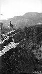
The Apache Kid Wilderness in the Cibola National Forest. Photo: US Forest Service.
USA New Mexico relief location map.svg
Red pog.svg
Usa edcp relief location map.png
Red pog.svg
Location New Mexico, United States
Nearest city Albuquerque, NM
Coordinates 34°17′49″N107°24′47″W / 34.297°N 107.413°W / 34.297; -107.413
Area1,633,783 acres (6,611.69 km2) [1]
EstablishedDecember 3, 1931 [2]
Governing body U.S. Forest Service
Website Cibola National Forest

The Cibola National Forest (pronounced SEE-bo-lah) is a 1,633,783 acre (6,611.7 km2) United States National Forest in New Mexico, USA. The name Cibola is thought to be the original Zuni Indian name for their pueblos or tribal lands. The name was later interpreted by the Spanish to mean "buffalo." [3] The forest is disjointed with lands spread across central and northern New Mexico, west Texas and Oklahoma. The Cibola National Forest is divided into four Ranger Districts: the Sandia, Mountainair, Mt. Taylor, and Magdalena. The Forest includes the San Mateo, Magdalena, Datil, Bear, Gallina, Manzano, Sandia, Mt. Taylor, and Zuni Mountains of west-central New Mexico. The Forest also manages four National Grasslands that stretch from northeastern New Mexico eastward into the Texas Panhandle and western Oklahoma. The Cibola National Forest and Grassland is administered by Region 3 of the United States Forest Service from offices in Albuquerque, New Mexico. Elevation ranges from 5,000 ft (1,500 m) to 11,301 ft (3,445 m). (The preceding figures do not include any of the four National Grasslands mentioned below, which are detailed in their individual articles.) The descending order of Cibola National Forest acres (not counting the three Grassland areas) by county are: Socorro, Cibola, McKinley, Catron, Torrance, Bernalillo, Sandoval County, New Mexico, Lincoln, Sierra, and Valencia counties in New Mexico. The Cibola National Forest currently has 137,701 acres designated as Wilderness. In addition to these acres, it has 246,000 acres classified as Inventoried Roadless Areas pursuant to the Roadless Area Conservation Rule. [4]

Contents

Map of Cibola National Forest Cibola National Forest map.jpg
Map of Cibola National Forest

The Cibola National Forest is organized into several divisions over three states. The Rita Blanca National Grassland 92,989 acres (376.3 km2) in Dallam County, Texas and Cimarron County, Oklahoma, Black Kettle National Grassland 31,286 acres (126.6 km2) in Roger Mills County, Oklahoma and Hemphill County, Texas, and McClellan Creek National Grassland 1,449 acres (5.9 km2) in Gray County, Texas are in the Oklahoma-Texas panhandle region. The combined Cibola National Grasslands are 262,141 acres (1,060.8 km2) in size.

New Mexico is home to much of the Forest, including the Kiowa National Grassland 136,417 acres (552.1 km2) in Harding, Union, Mora, and Colfax counties, New Mexico. The Cibola National Forest's Sandia Ranger District is just east of Albuquerque in Central New Mexico and includes the most visited mountains in the state of New Mexico. The Sandia District includes national forest land in eastern Bernalillo and southeastern Sandoval counties, and includes the Sandia Peak Tram and the Sandia Crest National Scenic Byway. The Sandia Mountains lie in the northern portion of the District. It is here where Congress designated the Sandia Mountain Wilderness (37,200 acres) in 1978. The Cibola's Sandia Ranger District also includes the Manzanita Mountains, which stretch south, between the Sandia and the Manzano Mountains. The Manzano Mountains are managed by the Cibola National Forest's Mountainair Ranger District. [5]

View from Sandia Peak, in the Sandia Mountains. In the background is Albuquerque, New Mexico. In the center is a tramway car moving along the Sandia Peak Tramway. 6.18.08SandiaMountainsByLuigiNovi82.jpg
View from Sandia Peak, in the Sandia Mountains. In the background is Albuquerque, New Mexico. In the center is a tramway car moving along the Sandia Peak Tramway.

The Mountainair Ranger District manages national forestland in Torrance, northwestern Lincoln, and eastern Valencia counties, which are in central New Mexico. Within the Mountainair District are the Gallinas Mountains and the Manzano Mountains. Congress designated the Manzano Wilderness in 1978. The Mount Taylor Ranger District manages land in northern Cibola, southern McKinley, and western Sandoval counties in western New Mexico. Mount Taylor and Zuni Mountains are within the Mount Taylor District.

Overseeing approximately 800,000 acres, the Magdalena Ranger District is the largest of the Cibola National Forest's four mountain districts. The Cibola’s Magdalena District manages land in south central New Mexico in western Socorro, northeastern Catron, and northern Sierra counties. The Bear Mountains, Datil Mountains, Magdalena Mountains and San Mateo Mountains are all within the Magdalena District. There are two Wilderness areas in this District - the Apache Kid (44,626 acres) and the Withington (19,000 acres) Wilderness areas, both of which are in the San Mateo Mountains. In addition to the designated Wilderness, the Magdalena Ranger District has 205,972 acres of Inventoried Roadless Areas. The Magdalena Ranger District's officers are stationed in the Village of Magdalena. The District has roots in the Gila Forest Reserve, created by President William McKinley in 1899, making the U.S. Forest Service the “oldest continuous business in Magdalena.” [6]

Ecology

Cibola biomes range from Chihuahuan desert to short grass prairie to piñon-juniper to sub-alpine spruce and fir. The region also boasts wildlife as diverse as the biomes they inhabit.

Animals represented include:

Due to the Rio Grande, a large variety of migrating waterfowl and other birds follow the river's flyway during the spring and fall. Birds of prey are also present using the updrafts and thermals along the north-south alignment of the central mountains for their migration.

The ‘sky islands’ region of the Cibola hosts more than 200 rare plant and animal species, with more than 30 species listed as endangered or threatened by New Mexico or the federal government. The region is home to more bird and mammal species than any other ecoregion in the Southwest. [7] The Rio Grande Watershed, which contains the Cibola’s four mountain ranger districts, ranked second out of eight watershed regions for species of greatest conservation need (SGCN) in the New Mexico Game and Fish’s Comprehensive Wildlife Conservation Strategy. [8] The Comprehensive Wildlife Conservation Strategy also ranked the Arizona-New Mexico Mountain Ecoregion, within which the Magdalena and Mt. Taylor Ranger Districts are located, second out of six ecoregions in the state for SGCN, with 80 identified SGCN. [8] The Nature Conservancy has identified the San Mateo, Magdalena, and Datil Mountains within the Cibola's Magdalena Ranger District as key conservation areas due to their ecological diversity. [7]

Recreation and special uses

The Cibola offers an abundance of recreational opportunities including picnicking, backpacking, camping, skiing, hiking, wildlife-viewing, star-gazing, horseback-riding, hunting and mountain biking as well as driving for pleasure and enjoying the aerial Sandia Peak Tramway with a restaurant and skiing at the top. The two most popular recreational activities on the Cibola are hiking/walking and viewing natural features with 35% and 15% of visitors citing these as their main activities, respectively. [9]

Resting and enjoying the view from the top of the Cienega Trail in the Sandia Mountains Hiking the Cienega Trail in the Sandia Mountains.jpg
Resting and enjoying the view from the top of the Cienega Trail in the Sandia Mountains

In addition to ample recreational opportunities, the Cibola provides special facilities for scientific research. The largest special use permit on the Cibola is for the Langmuir Research Site, with 31,000-acres on South Baldy Peak. The Langmuir Laboratory for Atmospheric Research was established to study atmospheric processes that result in lightning, hail, and rain. [10] The Magdalena Ridge Observatory (MRO), also located on South Baldy, studies astronomical events with a 2.4-m telescope and the Magdalena Ridge Observatory Interferometer. [11] Both Langmuir and MRO are operated by the New Mexico Institute of Mining and Technology.

Additional multiple uses that occur on the Cibola National Forest include grazing, mining, logging, and oil/gas development.

History

The lands in the Cibola National Forest have a rich cultural history. The forest itself grew out of lands first established as Forest Reserves in the late 1800s to protect natural resources, such as watersheds, trees, and soils. [12] The human and cultural history of these national forest lands stretch back well before the 1800s. Basham noted in his report documenting the archeological history of the Cibola’s Magdalena Ranger District that “[t]he heritage resources on the district are diverse and representative of nearly every prominent human evolutionary event known to anthropology. Evidence for human use of district lands date back 14,000 years to the Paleoindian period providing glimpses into the peopling of the New World and megafaunal extinction.“ [13]

Much of the now Magdalena Ranger District were a province of the Apache. Bands of Apache effectively controlled the Magdalena-Datil region from the seventeenth century until they were defeated in the Apache Wars in the late nineteenth century. [13] Outlaw renegades Butch Cassidy and the Wild Bunch and notorious Apaches like Cochise and Geronimo have ties to the San Mateos. Vicks Peak was named after Victorio, “a Mimbreño Apache leader whose territory included much of the south and southwest New Mexico.” [14] Famous for defying relocation orders in 1879 and leading his warriors “on a two-year reign of terror before he was killed,” Victorio is at least as highly regarded as Geronimo or Cochise among Apaches. [14] Perhaps the most famous outlaw was the Apache Kid whose supposed grave lies within the Apache Kid Wilderness. Stories of depredations by the Apache Kid, and of his demise, became so common and dramatic that in southwestern folklore they may be exceeded only by tales of lost Spanish gold. [13] Native Americans lingered in the San Mateos well into the 1900s. We know this by an essay written by Aldo Leopold in 1919 where he documents stumbling upon the remains of a recently abandoned Indian hunting camp. [15]

A mining rush followed the Apache wars – gold, silver, and copper were found in the mountains. It wasn’t until this time that extensive use of the area by non-Native Americans occurred. [16] While some mining activity, involving gold, silver, and copper, occurred in the southern part of the range near the end of the nineteenth century, [17] the prospecting/mining remnants are barely visible today due to collapse, topographic screening, and vegetation regrowth. While miners combed the mountains for mineral riches during the late nineteenth and early twentieth centuries, stockmen drove tens of thousands of sheep and cattle to stockyards at the village of Magdalena, then linked by rail with Socorro. [14] In fact, the last regularly used cattle trail in the United States stretched 125 miles westward from Magdalena. The route was formally known as the Magdalena Livestock Driveway, but more popularly known to cowboys and cattlemen as the Beefsteak Trail. The trail began use in 1865 and its peak was in 1919. The trail was used continually until trailing gave way to trucking and the trail official closed in 1971. [13]

Fires

In 2008 the Trigo Fire burned 13,709 acres (55.48 km2) mostly within the Mountainair Ranger District of the Cibola National Forest.

Related Research Articles

<span class="mw-page-title-main">Socorro County, New Mexico</span> County in New Mexico, United States

Socorro County is a county in the U.S. state of New Mexico. As of the 2020 census, the population was 16,595. The county seat is Socorro. The county was formed in 1852 as one of the original nine counties of New Mexico Territory. Socorro was originally the name given to a Native American village by Don Juan de Oñate in 1598. Having received vitally needed food and assistance from the native population, Oñate named the pueblo Socorro.

<span class="mw-page-title-main">Catron County, New Mexico</span> County in New Mexico, United States

Catron County is a county in the U.S. state of New Mexico. As of the 2020 census, the population was 3,579, making it New Mexico's third-least populous county. Its county seat is Reserve. Catron County is New Mexico's largest county by area.

<span class="mw-page-title-main">Datil, New Mexico</span> Census-designated place in New Mexico, United States

Datil is a census-designated place in Catron County, New Mexico, United States. As of the 2010 census it had a population of 54. Located at the intersection of U.S. Route 60 and New Mexico State Road 12, Datil is on the edge of the Cibola National Forest. The Very Large Array is also nearby. Rock climbers are attracted to Datil because it holds the Enchanted Tower, a climbing hotspot.

<span class="mw-page-title-main">Manzano Mountains</span> Mountain range in the central part of New Mexico, United States

The Manzano Mountains are a small mountain range in the central part of the U.S. state of New Mexico. They are oriented north–south and are 30 miles long. The center of the range lies due east of the town of Belen. The name "Manzano" is Spanish for "apple tree"; the mountains were named for apple orchards planted at the nearby town of Manzano.

Manzano Peak is the highest peak in the Manzano Mountains, a mountain range in the central part of the US State of New Mexico. It lies 7 miles (11 km) southwest of the town of Manzano and 18 miles (29 km) east-southeast of the town of Belen, in the Manzano Wilderness Area, part of the Mountainair Ranger District of the Cibola National Forest. It forms the striking southern anchor of the range, rising 3,900 feet (1,189 m) in 3 miles (5 km) above its western base. The summit is below the tree line, but has views to the east, south, and west.

<span class="mw-page-title-main">Magdalena Mountains</span>

The Magdalena Mountains are a regionally high, mountain range in Socorro County, in west-central New Mexico in the southwestern United States. The highest point in the range is South Baldy, at 10,783 ft, which is also the tallest peak in Socorro County. The range runs roughly north-south and is about 18 miles (28 km) long. The range lies just south of the village of Magdalena, and about 18 miles (28 km) west of Socorro. The Magdalena Mountains are an east-tilted fault-block range, superimposed on Cenozoic calderas. The complex geologic history of the range has resulted in spectacular scenery, with unusual and eye-catching rock formations. They form part of the western edge of the Rio Grande Rift Valley, fronting the La Jencia Basin. The mountains remain isolated and natural due to the absence of any significant human development within or near the range.

<span class="mw-page-title-main">San Mateo Mountains (Socorro County, New Mexico)</span> Landscape and mass

The San Mateo Mountains are a mountain range in Socorro County, in west-central New Mexico in the southwestern United States. The highest point in the range is West Blue Mountain, at 10,336 ft. The range runs roughly north-south and is about 40 miles (64 km) long. It lies about 25 miles (40 km) north-northwest of the town of Truth or Consequences and about 30 miles (48 km) southwest of Socorro. They should not be confused with the identically named range in Cibola and McKinley counties, north of this range.

Sandia Mountain Wilderness, part of Cibola National Forest, is located east of Albuquerque, New Mexico, and comprises much of Sandia Mountains. It became part of the National Wilderness Preservation System in 1978 by an act of the United States Congress and has a total of 37,877 acres (15,328 ha).

<span class="mw-page-title-main">U.S. Route 60 in New Mexico</span>

U.S. Route 60 (US 60) is an east–west United States Highway within New Mexico. It begins at the Arizona state line and continues east to the Texas state line.

<span class="mw-page-title-main">Apache Kid Wilderness</span> Protected wilderness area in New Mexico, United States

Apache Kid Wilderness is a 44,626-acre (18,060 ha) Wilderness area located within the Magdalena Ranger District of the Cibola National Forest in the state of New Mexico. Straddling a southern portion of the San Mateo Mountains of southwestern Socorro County, the area is characterized by rugged, narrow, and steep canyons bisecting high mountain peaks exceeding 10,000 feet (3,000 m). The highest peak is West Blue Mountain which reaches an elevation of 3,151 metres (10,338 ft).

Datil National Forest was a United States National Forest established in western New Mexico by the U.S. Forest Service in 1908. It was merged into another and ceased in 1931.

Magdalena National Forest was established as the Magdalena Forest Reserve by the U.S. Forest Service in New Mexico on November 5, 1906, with 153,781 acres (622.33 km2). It became a National Forest on March 4, 1907. On July 1, 1908, San Mateo National Forest was added. On February 23, 1909, the forest was combined with Datil National Forest

Manzano National Forest was established as the Manzano Forest Reserve by the U.S. Forest Service in New Mexico on November 6, 1906 with 459,726 acres (1,860.45 km2). It became a National Forest on March 4, 1907. On April 16, 1908 Mount Taylor National Forest and other lands were added. On September 10, 1914 Zuni National Forest was added. On December 3, 1931 the name was changed to Cibola National Forest and further lands were added.

Mount Taylor National Forest was established as the Mount Taylor Forest Reserve by the U.S. Forest Service in New Mexico on October 5, 1906 with 110,525 acres (447.28 km2). It became a National Forest on March 4, 1907. On April 16, 1908 Mount Taylor was combined with Manzano National Forest.

Zuni National Forest was established by the U.S. Forest Service in Arizona and New Mexico on March 2, 1909 with 670,981 acres (2,715.36 km2) from parts of the Zuni and Navajo and other tribal lands. On September 10, 1914 Zuni was transferred to Manzano National Forest. The lands are now part of the Cibola National Forest.

<span class="mw-page-title-main">Datil Mountains</span>

The Datil Mountains are a small range on the northern edge of the Mogollon-Datil volcanic field, just northwest of the Plains of San Agustin in the U.S. state of New Mexico. The range lies in Socorro and Catron Counties, north of the town of Datil, New Mexico and takes its name from the Spanish word for “date,” dating back over two hundred years. In The Place Names of New Mexico, Robert Julyan suggests two possible explanations for the name: 1) that “the seedpods of the broad-leafed yucca sufficiently resembled dates” or 2) “the Spanish applied the name to the fruit of the prickly pear cactus.” The area includes the major ridgeline of Madre Mountain, which is sacred ground to the Acoma, Laguna, and Zuni tribes, as well as several other unnamed peaks and ridges.

<span class="mw-page-title-main">Bear Mountains</span>

The Bear Mountains lie just north of the village of Magdalena and north of the Magdalena Mountains in New Mexico. The Bear Mountains are located within the Magdalena Ranger District of the Cibola National Forest. There are two Inventoried Roadless Areas (IRA) within the Bear Mountains: the Scott Mesa IRA and the Goat Spring IRA. The Bureau of Land Management’s Sierra Ladrones Wilderness Study Area stretches to the northeast of the Bear Mountains and connects the Bear Mountains with the 230,000-acre Sevilleta National Wildlife Refuge to the east. The world-renowned Very Large Array lies to the southwest of the Bear Mountains.

<span class="mw-page-title-main">Withington Wilderness</span>

The Withington Wilderness is a 19,000-acre designated Wilderness area located within the Cibola National Forest in western New Mexico. Located in the Magdalena Ranger District, approximately 20 miles southwest of Magdalena, New Mexico, the wilderness area lies around 10,100 ft. Mount Withington, on the eastern slope of the San Mateo Mountains in Socorro County, New Mexico, United States.

<span class="mw-page-title-main">New Mexico Wilderness Act of 1980</span> U.S. federal law

New Mexico Wilderness Act of 1980, Public Law 96-550, is a U.S. federal law that authorized the establishment of a number of designated Wilderness Areas on National Forest land in New Mexico. The law also added additional lands to four existing Wilderness Areas in New Mexico, and named several Forest areas for study as potential Wilderness Areas. The law also created two new National Park Service units, Chaco Culture National Historical Park and Salinas National Monument, from existing NPS lands. By means of this law approximately 400,000 acres of forest land were designated as Wilderness Areas, as described by the Wilderness Act of 1964, and approximately 75,000 additional acres were designated as Wilderness Study Areas for possible future inclusion in the Wilderness program.

References

  1. "Land Areas of the National Forest System" (PDF). U.S. Forest Service. January 2012. Retrieved June 26, 2012.
  2. "The National Forests of the United States" (PDF). ForestHistory.org. Archived from the original (PDF) on October 28, 2012. Retrieved July 26, 2012.
  3. Cibola National Forest and Grasslands. "About the Forest". US Forest Service.
  4. Final EIS for the Roadless Area Conservation Rule, Volume 2 (PDF). US Forest Service.
  5. Cibola National Forest. "Sandia Ranger District".
  6. Cibola National Forest. "Magdalena Ranger District".
  7. 1 2 The Nature Conservancy (2004). Chapter 10: Ecological & Biological Diversity of the Cibola National Forest, Mountain Districts in Ecological and Biological Diversity of National Forests in Region 3.
  8. 1 2 Comprehensive Wildlife Conservation Strategy of New Mexico. New Mexico Department of Game & Fish. 2006.
  9. National Visitor Use Monitoring Results for FY 2011 for the Cibola National Forest (PDF). US Forest Service. 2012.[ permanent dead link ]
  10. Langmuir Laboratory for Atmospheric Research. "Home".
  11. Magdalena Ridge Observatory. "About MRO".
  12. "History & Culture: The Southwest and the Forest Service". US Forest Service.
  13. 1 2 3 4 Basham, M. (2011). Magdalena Ranger District Background for Survey. US Forest Service.
  14. 1 2 3 Julyan, Robert (2006). The Mountains of New Mexico. University of New Mexico Press.
  15. Leopold, A. (2003). Brown, D. E.; Carmony, N. B. (eds.). Aldo Leopold’s Southwest. University of New Mexico Press.
  16. Ugnade, H.E. (1972). Guide to the New Mexico Mountains. University of New Mexico Press.
  17. Butterfield, Mike, and Greene, Peter, Mike Butterfield's Guide to the Mountains of New Mexico, New Mexico Magazine Press, 2006, ISBN   978-0-937206-88-1