Pontotoc County is in the south central part of Oklahoma. As of the 2020 census, the population was 38,065. Its county seat is Ada. The county was created at statehood from part of the Chickasaw Nation in Indian Territory. It was named for a historic Chickasaw tribal area in Mississippi. According to the Encyclopedia of Oklahoma History and Culture, Pontotoc is usually translated "cattail prairie" or "land of hanging grapes."

The Chickasaw are an Indigenous people of the Southeastern Woodlands, United States. Their traditional territory was in northern Mississippi, northwestern and northern Alabama, western Tennessee and southwestern Kentucky. Their language is classified as a member of the Muskogean language family. In the present day, they are organized as the federally recognized Chickasaw Nation.

Winston County is a county located in the U.S. state of Mississippi. In the 2020 census, the population was 17,714. Its county seat is Louisville. The county is named for Louis Winston (1784–1824), a colonel in the militia, a prominent lawyer, and a judge of the Mississippi Supreme Court.

Webster County is a county located in center of the U.S. state of Mississippi, bordered on the south by the Big Black River. As of the 2020 census, the population was 9,926.
Pontotoc County is a county located in the U.S. state of Mississippi. As of the 2020 census, the population was 31,184. Its county seat is Pontotoc. It was created on February 9, 1836, from lands ceded to the United States under the Chickasaw Cession. Pontotoc is a Chickasaw word meaning "land of hanging grapes". The original Natchez Trace and the current-day Natchez Trace Parkway both pass through the southeast corner of Pontotoc County.

Oktibbeha County is a county in the east central portion of the U.S. state of Mississippi. As of the 2020 census the population was 51,788. The county seat is Starkville. The county's name is derived from a local Native American word meaning either "bloody water" or "icy creek". The Choctaw had long occupied much of this territory prior to European exploration and United States acquisition.

Scouting in Mississippi has a long history, from the 1910s to the present day, serving thousands of youth in programs that suit the environment in which they live.
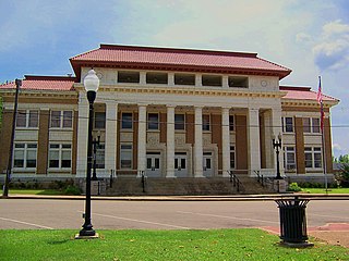
Pontotoc is a city in and the county seat of Pontotoc County, Mississippi, located to the west of the larger city of Tupelo. The population was 5,625 at the 2010 census. Pontotoc is a Chickasaw word that means, “Land of the Hanging Grapes.” A section of the city largely along Main Street and Liberty Street has been designated the Pontotoc Historic District and is listed on the National Register of Historic Places. The Treaty of Pontotoc Site is also listed on the National Register. The Treaty of Pontotoc Creek, part of U.S. president Andrew Jackson's Indian Removal policy, ceded millions of acres of Native American lands and relocated the Chicakasaw west of the Mississippi River.

The Tombigbee River is a tributary of the Mobile River, approximately 200 mi (325 km) long, in the U.S. states of Mississippi and Alabama. Together with the Alabama, it merges to form the short Mobile River before the latter empties into Mobile Bay on the Gulf of Mexico. The Tombigbee watershed encompasses much of the rural coastal plain of western Alabama and northeastern Mississippi, flowing generally southward. The river provides one of the principal routes of commercial navigation in the southern United States, as it is navigable along much of its length through locks and connected in its upper reaches to the Tennessee River via the Tennessee-Tombigbee Waterway.

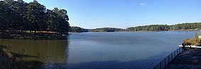
Tishomingo State Park is a public recreation area located in the foothills of the Appalachian Mountains in Tishomingo County, some 45 miles (72 km) northeast of Tupelo, Mississippi. The major feature of the park is Bear Creek Canyon and its generous sandstone outcroppings. Activities in the park include canoeing, rock climbing, fishing, and hiking. The park sits at Milepost 304 of Natchez Trace Parkway, a scenic road operated by the National Park Service that runs directly through the park.

The Noxubee River (NAHKS-uh-bee) is a tributary of the Tombigbee River, about 90.6 miles (145.8 km) long, in east-central Mississippi and west-central Alabama in the United States. Via the Tombigbee, it is part of the watershed of the Mobile River, which flows to the Gulf of Mexico.
The Chickasaw Nation is a federally recognized Native American tribe with headquarters in Ada, Oklahoma, in the United States. They are an Indigenous people of the Southeastern Woodlands, originally from northern Mississippi, northwestern Alabama, southwestern Kentucky, and western Tennessee. Today, the Chickasaw Nation is the 13th largest tribe in the United States.

Mississippi Highway 15 is a state highway in Mississippi. At almost 324 miles (521 km), it is the longest highway in the Mississippi Highway System. MS 15 is divided into two sections due to a large gap between Stone County and Perry County. The southern section begins at Interstate 10 (I-10) and I-110 in Biloxi and ends at a junction with MS 26 near Wiggins, and the northern section begins at a junction with U.S. Route 98 near Beaumont and ends as a continuation as SR 125 near Walnut. It serves a total of 15 counties.

The Pushmataha Area Council is part of the Boy Scouts of America. It renders service to Scout units in ten counties of North Mississippi, providing skills training and character development to boys and girls between the ages of 5 and 18. The council also serves boys and girls between the ages of 14 and 21 through Venturing Crews and Explorer posts.
Seven segments of the historic Natchez Trace are listed on the National Register of Historic Places (NRHP). Also there are additional NRHP-listed structures and other sites along the Natchez Trace, which served the travelers of the trace and survive from the era of its active use.

The Treaty of Pontotoc Creek was a treaty signed on October 20, 1832 by representatives of the United States and the Chiefs of the Chickasaw Nation assembled at the National Council House on Pontotoc Creek in Pontotoc, Mississippi. The treaty ceded the 6,283,804 million acres of the remaining Chickasaw homeland in Mississippi in return for Chickasaw relocation on an equal amount of land west of the Mississippi River.

Mississippi Highway 41 (MS 41) is a state highway in northeastern Mississippi. The route starts at U.S. Route 45 and US 278 north of Wren and travels westwards. It then intersects US 45 Alt. east of Okolona. The road enters Okolona, and intersects MS 32 and MS 245. MS 41 then turns northwest and travels toward Pontotoc. Once inside the city, the route turns north at MS 15 and travels through downtown Pontotoc. MS 41 ends at its intersection with MS 9 and MS 338. The route that became MS 41 was first used as an Indian trail. The route was designated by 1932 from Amory to Pontotoc, and it was truncated from Amory to US 45 by 1955. The entirety of MS 41 was paved by 1958.