The Au Sable River is a 138-mile-long (222 km) river in the Lower Peninsula of the U.S. state of Michigan. Rising in the Northern Lower Peninsula, the river flows in a generally southeasterly direction to its mouth at Lake Huron at the communities of Au Sable and Oscoda.It is considered one of the best brown trout fisheries east of the Rockies and has been designated a blue ribbon trout stream by the Michigan Department of Natural Resources. A map from 1795 located in the United States Gazetteer calls it the Beauais River. In French, the river is called the Rivière au sable, literally "Sand River".

Cass Lake is a city in Cass County, Minnesota, United States, located within the boundaries of the Leech Lake Indian Reservation. It is surrounded by Pike Bay Township. Cass Lake had a population of 675 in the 2020 census. It is notable as the headquarters location of Minnesota Chippewa Tribe and Leech Lake Band of Ojibwe, as well as the Chippewa National Forest.

The Ouachita National Forest is a vast congressionally-designated National Forest that lies in the western portion of Arkansas and portions of extreme-eastern Oklahoma, USA.

The Hoosier National Forest is a property managed by the United States Forest Service in the hills of southern Indiana. Composed of four separate sections, it has a total area of 202,814 acres. Hoosier National Forest's headquarters are located in Bedford, with a regional office in Tell City. Prominent places within the Forest include the Lick Creek Settlement, Potts Creek Rockshelter Archeological Site, and Jacob Rickenbaugh House.

Cass Lake is a lake in north central Minnesota in the United States. It is approximately 10 mi (16 km) long and 7 mi (11 km) wide, located in Cass and Beltrami counties, within the Chippewa National Forest and the Leech Lake Indian Reservation, adjacent to its namesake city of Cass Lake. It is the 11th largest lake in Minnesota, and the 8th largest lake lying entirely within the borders of the state.

The Apache–Sitgreaves National Forests is a 2.76-million-acre (11,169 km2) United States National Forest which runs along the Mogollon Rim and the White Mountains in east-central Arizona and into the U.S. state of New Mexico. Formerly two forests, it is currently managed as one unit by USDA Forest Service from the Forest Supervisors Office in Springerville, Arizona. Apache–Sitgreaves has over 400 species of wildlife. With its high elevation and cool summer breezes it is a popular weekend destination from the hot desert for Phoenix, Arizona, residents. The forest is divided into 5 Ranger Districts that span almost 300 miles (480 km) from Clifton, Arizona in the east-central portion of Arizona to the eastern boundary of the Coconino National Forest in north-central Arizona. The Apache–Sitgreaves National Forest borders the western and northern borders of the Fort Apache Indian Reservation. It is located in parts of Greenlee, Apache, Navajo, and Coconino counties in eastern and east-central Arizona, and Catron County in western New Mexico. The more northwesterly Sitgreaves National Forest portion lies adjacent to the north side of the Fort Apache Indian Reservation and is located entirely in Arizona, within Navajo, Apache, and Coconino counties. It has a total area of 818,651 acres (3,313 km2). The more southeasterly and much larger Apache National Forest portion lies adjacent to the east side of the Fort Apache and the San Carlos Indian Reservations. It lies on both sides of the border with New Mexico, in Greenlee, Catron, and Apache counties. It has a total area of 1,813,601 acres (7,339 km2).

Kisatchie National Forest, the only National forest in Louisiana, United States, is located in the forested piney hills and hardwood bottoms of seven central and northern parishes. It is part of the Cenozoic uplands and has large areas of longleaf pine forests. It is one of the largest pieces of natural landscape in Louisiana, with some 604,000 acres (2,440 km2) of public land, more than half of which is vital longleaf pine and flatwoods vegetation. These support many rare plant and animal species. There are also rare habitats, such as hillside seepage bogs and calcareous prairies. The forest also contains and provides a buffer for the Kisatchie Hills Wilderness, a nationally designated wilderness area that contributes to protecting biodiversity of the coastal plain region of the United States.

The Leech Lake Reservation is an Indian reservation located in the north-central Minnesota counties of Cass, Itasca, Beltrami, and Hubbard. The reservation forms the land base for the federally recognized Leech Lake Band of Ojibwe, one of six bands comprising the Minnesota Chippewa Tribe, organized in 1934. The Leech Lake Reservation has the second highest population of any reservation in Minnesota with White Earth Nation being the largest Minnesota Ojibwe tribe, Leech Lake Nation has a resident population of 11,388 indicated by the 2020 census.
The Bighorn National Forest is a U.S. National Forest located in northern Wyoming, United States and consists of over 1.1 million acres (4,500 km2). Created as a US Forest Reserve in 1897, it is one of the oldest government-protected forest lands in the U.S. The forest is well east of the continental divide and extends from the Montana border for a distance of 80 miles (130 km) along the spine of the Bighorn Mountains, an outlying mountain range separated from the rest of the Rocky Mountains by Bighorn Basin. Elevations range from 5,000 feet (1,500 m) along the sagebrush and grass-covered lowlands at the foot of the mountains, to 13,189 feet (4,020 m) on top of Cloud Peak, the highest point in the Bighorn Mountains. Around 99% of the land is above 1,500 metres (4,900 ft). The forest is named after the Bighorn River, which is partially fed by streams found in the forest. Streams in the range are fed primarily by snowmelt and snowmelt mixed with driving rainfall.

Superior National Forest, part of the United States National Forest system, is located in the Arrowhead Region of the state of Minnesota between the Canada–United States border and the north shore of Lake Superior. The area is part of the greater Boundary Waters region along the border of Minnesota and the Canadian province of Ontario, a historic and important thoroughfare in the fur trading and exploring days of New France and British North America.
Pillager Band of Chippewa Indians are a historical band of Chippewa (Ojibwe) who settled at the headwaters of the Mississippi River in present-day Minnesota. Their name "Pillagers" is a translation of Makandwewininiwag, which literally means "Pillaging Men". The French called them Pilleurs, also a translation of their name. The French and Americans adopted their autonym for their military activities as the advance guard of the Ojibwe in the invasion of the Dakota country.

Lincoln National Forest is a unit of the U.S. Forest Service located in southern New Mexico. The Lincoln National Forest covers an extensive 1.1 million acres in southeastern New Mexico. Established by Presidential Proclamation in 1902 as the Lincoln Forest Reserve, the 1,103,897 acres (4,467.31 km2) forest begins near the Texas border and contains lands in parts of Chaves, Eddy, Lincoln, and Otero counties. The Lincoln National Forest is home to three major mountain ranges: Sacramento, Guadalupe and Capitan. The three Ranger Districts within the forest contain all or part of a total of four mountain ranges, and include a variety of different environmental areas, from desert to heavily forested mountains and sub-alpine grasslands. Clean air, water, and soil are necessary elements that the National Forests contribute to the environment. Established to balance conservation, resource management, and recreation, the lands of the Lincoln National Forest include important local timber resources, protected wilderness areas, and popular recreation and winter sports areas. The forest headquarters is located in Alamogordo, N.M. with local offices in Carlsbad, Cloudcroft, and Ruidoso.

State Route 180 (SR 180) is a 26.0-mile-long (41.8 km) state highway in the northeastern part of the U.S. state of Georgia. Its routing is located within portions of Union and Towns counties.
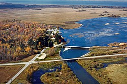
Pine Point Research Natural Area is a natural area that is protected by the United States Department of Agriculture, specifically through the branch of the Forest Service. It was established in 1932 and consists of 1,375 acres (5.56 km2) of land. It is located in Cass County, Minnesota and is part of the Chippewa National Forest. The natural area is bounded on the north, east, and west sides by Lake Leech. To the south is Onigum, an unincorporated community that had been an Indian agency.

The Cut Foot Sioux Trail is a 22-mile (35 km) loop trail in the Chippewa National Forest of Minnesota, United States. It follows gravel and sand forestry roads that are now used for hiking, biking, cross-country skiing and horse back riding. The trail passes by several lakes.
The Battleground State Forest is a state forest located near Gould Township in Cass County, Minnesota. It is managed by the Minnesota Department of Natural Resources. It lies entirely within the boundaries of the Chippewa National Forest, additionally, and a portion of the forest falls within the borders of the Leech Lake Indian Reservation.
The Bowstring State Forest is a state forest located in Itasca and Cass Counties in Minnesota. It is located entirely within the boundaries of the federally managed Chippewa National Forest, and is managed by the Minnesota Department of Natural Resources.

The Trail of the Ancients is a collection of National Scenic Byways located in the U.S. Four Corners states of Utah, Colorado, New Mexico, and Arizona. These byways comprise:

The Whitefish Bay National Forest Scenic Byway is a National Forest Scenic Byway that runs along Whitefish Bay in the Hiawatha National Forest in the U.S. state of Michigan. The byway mostly follows Federal Forest Highway 42 (FFH 42) through Chippewa County in the Upper Peninsula. As a forest highway, it is maintained jointly by the Chippewa County Road Commission (CCRC) and the U.S. Forest Service (USFS). The route of the byway first existed as an earth road by the 1930s; it was improved into a gravel road in the 1940s and paved between the 1950s and the 1980s. The byway designation was created in 1989.
Minnesota Scenic Byways are a system of roads in the U.S. state of Minnesota which pass through areas of scenic, cultural, or recreational significance. There are currently 22 scenic byways in the system with a total length of 2,948 miles (4,744 km). Eight of these byways are also designated as National Scenic Byways, and the North Shore Scenic Drive is further designated as an All-American Road.