
The Mississippi River is the second-longest river and chief river of the second-largest drainage system on the North American continent, second only to the Hudson Bay drainage system. From its traditional source of Lake Itasca in northern Minnesota, it flows generally south for 2,340 miles (3,770 km) to the Mississippi River Delta in the Gulf of Mexico. With its many tributaries, the Mississippi's watershed drains all or parts of 32 U.S. states and two Canadian provinces between the Rocky and Appalachian mountains. The main stem is entirely within the United States; the total drainage basin is 1,151,000 sq mi (2,980,000 km2), of which only about one percent is in Canada. The Mississippi ranks as the thirteenth-largest river by discharge in the world. The river either borders or passes through the states of Minnesota, Wisconsin, Iowa, Illinois, Missouri, Kentucky, Tennessee, Arkansas, Mississippi, and Louisiana.

The Great River Road is a collection of state and local roads that follow the course of the Mississippi River through ten states of the United States. They are Minnesota, Wisconsin, Iowa, Illinois, Missouri, Kentucky, Tennessee, Arkansas, Mississippi and Louisiana. It formerly extended north into Canada, serving the provinces of Ontario and Manitoba. The road is designated as both a National Scenic Byway and an All-American Road in several states along the route.

Itasca County is located in the State of Minnesota. As of the 2020 census, the population was 45,014. Its county seat is Grand Rapids. The county is named after Lake Itasca, which is in turn a shortened version of the Latin words veritas caput, meaning 'truth' and 'head', a reference to the source of the Mississippi River. Portions of the Bois Forte and Leech Lake Indian reservations are in the county.

Trout Lake Township is located in north central Minnesota in Itasca County, United States. It is bordered by the City of Coleraine to the west and north, City of Bovey on the north, an unorganized township on the east, and Blackberry Township to the south. Town government was adopted on March 6, 1894. The population was 1,056 at the 2020 census.
Itasca State Park is a state park of Minnesota, United States, and contains the headwaters of the Mississippi River. The park spans 32,690 acres (132.3 km2) of northern Minnesota, and is located about 21 miles (34 km) north of Park Rapids, Minnesota and 25 miles (40 km) from Bagley, Minnesota. The park is part of Minnesota's Pine Moraines and Outwash Plains Ecological Subsection and is contained within Clearwater, Hubbard, and Becker counties.

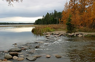
Lake Itasca is a small glacial lake, approximately 1.8 square miles in area. Located in southeastern Clearwater County, in the Headwaters area of north central Minnesota, it is notable for being the headwater of the Mississippi River. The lake is in Itasca State Park. It has an average depth of 20 to 35 feet and is 1,475 feet (450 m) above sea level.
Itasca is a word coined by Henry Schoolcraft and may refer to:

Cass Lake is a lake in north central Minnesota in the United States. It is approximately 10 mi (16 km) long and 7 mi (11 km) wide, located in Cass and Beltrami counties, within the Chippewa National Forest and the Leech Lake Indian Reservation, adjacent to its namesake city of Cass Lake. It is the 11th largest lake in Minnesota, and the 8th largest lake lying entirely within the borders of the state.

Lake Bemidji is a small glacially-formed lake, approximately 11 square miles in area, in northern Minnesota in the United States. Located less than 50 miles (80 km) downstream from the source of the Mississippi River, it both receives and is drained by the Mississippi.

The Leech Lake Reservation is an Indian reservation located in the north-central Minnesota counties of Cass, Itasca, Beltrami, and Hubbard. The reservation forms the land base for the federally recognized Leech Lake Band of Ojibwe, one of six bands comprising the Minnesota Chippewa Tribe, organized in 1934. The Leech Lake Reservation has the highest population of any reservation in Minnesota, with a resident population of 11,388 indicated by the 2020 census.

The Arrowhead Region is located in the northeastern part of the U.S. state of Minnesota, so called because of its pointed shape. The predominantly rural region encompasses 10,635.26 square miles (27,545.2 km2) of land area and includes Carlton, Cook, Lake and Saint Louis counties. Its population at the 2000 census was 248,425 residents. The region is loosely defined, and Aitkin, Itasca, and Koochiching counties are sometimes considered as part of the region, increasing the land area to 18,221.97 square miles (47,194.7 km2) and the population to 322,073 residents. Primary industries in the region include tourism and iron mining.

Chippewa National Forest is a National Forest located in north central Minnesota, United States, in the counties of Itasca, Cass and Beltrami. Forest headquarters are located in Cass Lake, Minnesota. There are local ranger district offices in Blackduck, Deer River and Walker.

The Minnesota Department of Natural Resources, or Minnesota DNR, is the agency of the U.S. state of Minnesota charged with conserving and managing the state's natural resources. The agency maintains areas such as state parks, state forests, recreational trails, and recreation areas as well as managing minerals, wildlife, and forestry throughout the state. The agency is divided into six divisions - Ecological & Water Resources, Enforcement, Fish & Wildlife, Forestry, Lands & Minerals, and Parks & Trails.

The U.S. State of Minnesota is the northernmost state outside Alaska; its isolated Northwest Angle in Lake of the Woods is the only part of the 48 contiguous states lying north of the 49th parallel north. Minnesota is in the U.S. region known as the Upper Midwest in interior North America. The state shares a Lake Superior water border with Michigan and Wisconsin on the northeast; the remainder of the eastern border is with Wisconsin. Iowa is to the south, North Dakota and South Dakota are to the west, and the Canadian provinces of Ontario and Manitoba are to the north. With 87,014 square miles (225,370 km2), or approximately 2.26% of the United States, Minnesota is the 12th largest state.

Jacob Vandenberg Brower (1844–1905) was a prolific writer of the Upper Midwest region of the United States who championed the location and protection of the utmost headwaters of the Mississippi and Missouri rivers.
Inger is an unincorporated community and census-designated place (CDP) in Itasca County, Minnesota, United States, along the Bowstring River of the Leech Lake Indian Reservation. As of the 2010 census, its population was 212.

The Winnibigoshish Lake Dam is a dam at the outlet of Lake Winnibigoshish into the Mississippi River in Minnesota, United States. The dam crosses the county line between Cass County and Itasca County, and lies within the Leech Lake Indian Reservation. The first dam on the site was built by the United States Army Corps of Engineers from 1881 to 1884 to regulate the flow of water on the Upper Mississippi River. A constant flow was desired by loggers, fur traders, and millers downstream at St. Anthony Falls. The current structure was built in 1899. Lake Winnibigoshish is Minnesota's fifth largest lake, at 67,000 acres (270 km2).

Wisconsin, a state in the Midwestern United States, has a vast and diverse geography famous for its landforms created by glaciers during the Wisconsin glaciation 17 thousand years ago. The state can be generally divided into five geographic regions—Lake Superior Lowland, Northern Highland, Central Plain, Eastern Ridges & Lowlands, and Western Upland. The southwestern part of the state, which was not covered by glaciers during the most recent ice age, is known as the Driftless Area. The Wisconsin glaciation formed the Wisconsin Dells, Devil's Lake, and the Baraboo Range. A number of areas are protected in the state, including Devil's Lake State Park, the Apostle Islands National Lakeshore, and the Chequamegon–Nicolet National Forest.
The Mississippi River Trail is a designated bicycle and pedestrian trail that traverses the shores of the Mississippi River in the United States. The trail extends from the headwaters at Lake Itasca in Minnesota to near the mouth of the river in Venice, Louisiana. Much of the trail’s 3,000 miles (4,800 km) follows roadways used by motor vehicles, although some of the route is on multi-use trails. The segment in Minnesota has been designated as U.S. Bicycle Route 45, part of the U.S. Bicycle Route System.

