Blanco County is a United States county located in the U.S. state of Texas. It is located in Central Texas and its county seat is Johnson City.
Johnson City is a city and the county seat of Blanco County, Texas, United States. The population was 1,656 at the 2010 census. Founded in 1879 by James P. Johnson, it was named for early settler Sam E. Johnson, Sr. Johnson City is part of the Texas-German belt region.
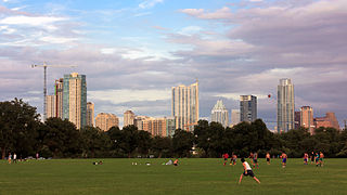
Zilker Metropolitan Park is a recreational area in south Austin, Texas at the juncture of Barton Creek and the Colorado River that comprises over 350 acres (142 ha) of publicly owned land. It is named after its benefactor, Andrew Jackson Zilker, who donated the land to the city in 1917. The land was developed into a park during the Great Depression in the 1930s. Today the park serves as a hub for many recreational activities and the hike and bike trail around Lady Bird Lake, both of which run next to the park. The large size of the park makes it a capable venue for large-scale events such as the Austin City Limits Music Festival and the Zilker Park Kite Festival. The park was listed in the National Register of Historic Places in 1997.

Lake Lyndon B. Johnson is a reservoir on the Colorado River in the Texas Hill Country about 45 miles northwest of Austin. The reservoir was formed in 1950 by the construction of Granite Shoals Dam by the Lower Colorado River Authority (LCRA). The Colorado River and the Llano River meet in the northern portion of the lake at Kingsland.

The following is an alphabetical list of articles related to the U.S. state of Texas.
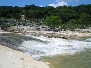
The Pedernales River is a tributary of the Colorado River, approximately 106 miles (171 km) long, in Central Texas in the United States. It drains an area of the Edwards Plateau, flowing west to east across the Texas Hill Country west of Austin. The name "Pedernales", first used in the middle 18th century, comes from a Spanish word for the flint rocks characteristic of the riverbed.

Hueco Tanks is an area of low mountains and historic site in El Paso County, Texas, in the United States. It is located in a high-altitude desert basin between the Franklin Mountains to the west and the Hueco Mountains to the east. Hueco is a Spanish word meaning hollows and refers to the many water-holding depressions in the boulders and rock faces throughout the region. Due to the unique concentration of historic artifacts, plants and wildlife, the site is under protection of Texas law; it is a crime to remove, alter, or destroy them.

Pecos National Historical Park is a United States National Historical Park in San Miguel County, New Mexico. The park, operated by the National Park Service, encompasses thousands of acres of landscape infused with historical elements from prehistoric archaeological ruins to 19th-century ranches, to a battlefield of the American Civil War. Its largest single feature is Pecos Pueblo also known as Cicuye Pueblo, a Native American community abandoned in historic times. First a state monument in 1935, it was made Pecos National Monument in 1965, and greatly enlarged and renamed in 1990. Two sites within the park, the pueblo and the Glorieta Pass Battlefield, are National Historic Landmarks.

Lyndon B. Johnson National Historical Park is a United States National Historical Park in central Texas about 50 miles (80 km) west of Austin in the Texas Hill Country. The park protects the birthplace, home, ranch, and grave of Lyndon B. Johnson, 36th president of the United States. During Johnson's administration, the LBJ Ranch was known as the Texas White House because the President spent approximately 20% of his time in office there.

The Tualatin River National Wildlife Refuge is a 1,856 acres (751 ha) wetlands and lowlands sanctuary in the northwestern part of the U.S. state of Oregon. Established in 1992 and opened to the public in 2006, it is managed by the United States Fish and Wildlife Service. Located in southeastern Washington County, 15 miles (24 km) southwest of Portland, the refuge is bordered by Sherwood, Tualatin and Tigard. A newer area, extending into northern Yamhill County, is located further west near the city of Gaston surrounding the former Wapato Lake.
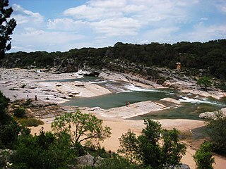
Pedernales Falls State Park is a 5,212-acre state park situated along the banks of the Pedernales River in Blanco County, Texas in the United States.

Stephen F. Austin State Park is a 663.3 acres (268 ha) state park located on the Brazos River in San Felipe, Austin County, Texas, United States. The park is managed by the Texas Parks and Wildlife Department.

Buescher State Park is a state park located just north of Smithville, Texas. The park consists of 1,016.7 acres (411 ha) of public land donated to the state by Mr. Emil and Mrs. Elizabeth Buescher, as well as the City of Smithville.

McKinney Falls State Park is a state park in Austin, Texas, United States at the confluence of Onion Creek and Williamson Creek. It is administered by the Texas Parks and Wildlife Department. The park opened on April 15, 1976 and is named after Thomas F. McKinney, a businessman, race horse breeder and rancher, who owned and lived on the land in the mid-to-late 19th century. The park is part of the El Camino Real de los Tejas National Historic Trail.

Ranch Road 1 is a Ranch Road located in Gillespie and Blanco counties, in the central region of the U.S. state of Texas. The highway is approximately 6.6 miles (10.6 km), and begins at U.S. Route 290 in Stonewall, running along the Pedernales River through Lyndon B. Johnson National Historical Park, the late President Lyndon Johnson's former ranch, and through Lyndon B. Johnson State Park and Historic Site, before terminating at US 290 near Hye. The road, designated in 1963, is the only road in the state that the Texas Department of Transportation (TxDOT) has designated as a "Ranch Road". In the earliest days of the state highway system, the route was a part of State Highway 20, and was later part of US 290 before that highway was relocated to the south.

Hill Country State Natural Area (HCSNA) preserves 5,369 acres (21.73 km2) of rugged, relatively pristine Hill Country terrain in Bandera County, Texas. It was opened to the public in 1984. Since HCSNA is designated a "Natural Area" rather than a "State Park", the first priority of the Texas Parks and Wildlife Department (TPWD) is the maintenance and preservation of the property's natural state. Accordingly, facilities are purposely somewhat primitive and recreational activities may be curtailed if the TPWD deems it necessary to protect the environment.
George Rufus Brown was a prominent Houston entrepreneur. With his brother Herman, Brown led Brown & Root Inc. to become one of the largest construction companies in the world and helped to foster the political career of Lyndon B. Johnson. The George R. Brown Convention Center and the George R. Brown School of Engineering of Rice University are both named in honor of him.

Devils River State Natural Area is a 37,000-acre (15,000 ha) section of three ecosystems, the Edwards Plateau, the Tamaulipan mezquital and the Chihuahuan Desert. It is located 66 miles (106 km) north of Del Rio, Val Verde County in the U.S. state of Texas. In 1857, future Confederate General John Bell Hood and a small U.S. Cavalry force skirmished with a group of Comanche braves along the banks of the Devil's River. In 1873, Texas Ranger Captain Pat Dolan had a skirmish with Native Americans, at the falls named for him. Dolan Falls in the natural area is the highest volume waterfall in Texas. The area was once home to the Comanche, Kiowa and Kickapoo tribes. Pictographs painted with red panthers are found in the area's fifty-three rock shelters, which archeologists have dated to 3000 b.c.. The "Buffalo dancer" pictograph depicts a Native American.
J. Roy White (1907–1985) was an American architect and artist known primarily for his architectural work in Austin, Texas and at the Lyndon B. Johnson Ranch.