Catron County, New Mexico

Last updated

Catron County
Reserve NM - 1.jpg
Catron County Courthouse in Reserve
Map of New Mexico highlighting Catron County.svg
Location within the U.S. state of New Mexico
New Mexico in United States.svg
New Mexico's location within the U.S.
Coordinates: 33°55′N108°25′W / 33.92°N 108.42°W / 33.92; -108.42
CountryFlag of the United States.svg United States
StateFlag of New Mexico.svg  New Mexico
FoundedFebruary 25, 1921
Named for Thomas B. Catron
Seat Reserve
Largest villageReserve
Area
  Total6,929 sq mi (17,950 km2)
  Land6,924 sq mi (17,930 km2)
  Water5.5 sq mi (14 km2)  0.08%
Population
 (2020)
  Total3,579
  Density0.52/sq mi (0.20/km2)
Time zone UTC−7 (Mountain)
  Summer (DST) UTC−6 (MDT)
Congressional district 2nd
Website www.catroncounty.us

Catron County is a county in the U.S. state of New Mexico. As of the 2020 census, the population was 3,579, [1] making it New Mexico's third-least populous county. Its county seat is Reserve. [2] Catron County is New Mexico's largest county by area.

Contents

History

Human settlement in the Catron County region dates to some of the earliest in the Americas. During the Clovis period, between 10999 BC and 8000 BC, and Folsom period, between 7999 BC and 5999 BC, the Ake Site was occupied near Datil. [3] Bat Cave, near Horse Springs, was occupied around 3,500 BC.

The Mimbres culture was expressed by the Mogollon people. They lived throughout the Catron County area from AD 1000 to 1130. Their art is renowned for its beauty.

In the 16th century, Spanish explorers and colonists came to the region, declaring it in 1598 to be part of Santa Fé de Nuevo México, a province of New Spain in the Americas. The province remained in Spanish control until Mexico gained independence in 1821. Under the 1824 Constitution of Mexico, this became the federally administered Territory of New Mexico.

Mexico ceded the region to the U.S. in the Treaty of Guadalupe Hidalgo in 1848 after being defeated in the Mexican–American War. In 1849, President Zachary Taylor proposed that New Mexico, including this region, immediately be admitted as a state in order to sidestep political conflict over the expansion of slavery in the territories. That did not happen. European-American settlers from the southern and eastern states began to arrive here, including some with enslaved African Americans. The territory did not become a state until 1912, long after the Civil War and abolition of slavery.

In 1880, Sergeant James C. Cooney was the first person to find silver and gold ore in the mountains of Catron County. He was reportedly killed by Chiricahua Apache led by Victorio that year, in what the European Americans called the "Alma Massacre". His remains are buried at Cooney's Tomb.

The foothills and canyons provided many hiding places for Apache warriors as they continued to resist American encroachment. During this time Cochise was another well-known Chiricahua leader. Noted war chief Goyaałé (Geronimo) had several hideouts in the county. Later in 1880, Buffalo Soldiers led by Sergeant George Jordan defeated Chiricahua Apache warriors led by Victorio in the Battle of Fort Tularosa. Four years later, self-appointed sheriff Elfego Baca was the hero of the so-called Frisco shootout in San Francisco Plaza.

The country also attracted European-American outlaws. In the mid-1880s Butch Cassidy and his Wild Bunch gang holed up at a ranch near Alma. Notorious outlaw Tom Ketchum also lived in Catron County around this time.

Socorro County included all of Catron County's territory from the creation of Santa Fé de Nuevo México until 1921. At that time, Catron County was organized and named for Thomas B. Catron, a leading figure in New Mexico statehood and its first US senator. In 1927, the State Legislature attempted to abolish both Socorro and Catron in order to create a new Rio Grande County. A court suit voided this act, and the two counties retained their independence. [4]

The Lightning Field, an art installation on the open earth, brought national attention to Quemado in this county in the late 1970s.

Geography

According to the U.S. Census Bureau, the county has a total area of 6,929 square miles (17,950 km2), of which 6,924 square miles (17,930 km2) is land and 5.5 square miles (14 km2) (0.08%) is water. [5]

Catron County is the largest county, by area, in New Mexico. At almost 7,000 square miles (18,000 km2), Catron County is larger than four states. With a population of only 3,400 people, the county is as sparsely populated as many an old West frontier area. The elk population at some 12,000 head, is much larger than the sparse human population.

Within the boundaries of Catron County lie parts of the Gila National Forest, the Apache National Forest and the Cibola National Forest. The establishment of these national forests, in the past called "forest reserves," led to the name Reserve being given to a village on the San Francisco River, which also serves as the County Seat. There are no stop lights in the whole county, so when license tests are given in Reserve, an artificial portable stop light is set up in a parking lot.

Bordering Arizona, Catron County affords the shortest route between Albuquerque and Phoenix or Tucson. Reserve can also be reached by following U.S. Route 180 north from Silver City and New Mexico State Road 12 east for a total of 99 miles (159 km).

In Catron County there is a volcanic area that until recently contained sufficient heat to cause steam to rise after a slight rain. It is called Burning Mountain and appears to have been used by the Apache for healing purposes. [6] The county is home to the Red Hill Volcanic Field as well as the Plains of San Agustin.

Mountains

Bodies of water

Forests

Adjacent counties

National protected areas

Demographics

Historical population
CensusPop.Note
1930 3,282
1940 4,88148.7%
1950 3,533−27.6%
1960 2,773−21.5%
1970 2,198−20.7%
1980 2,72023.7%
1990 2,563−5.8%
2000 3,54338.2%
2010 3,7255.1%
2020 3,579−3.9%
U.S. Decennial Census [7]
1790–1960 [8] 1900–1990 [9]
1990–2000 [10] 2010 [11]

2000 census

As of the 2000 census [12] of 2000, there were 3,543 people, 1,584 households, and 1,040 families living in the county. The population density was 0.51 people per square mile (0.20 people/km2). There were 2,548 housing units at an average density of 0.37 units per square mile (0.14/km2). The racial makeup of the county was 87.75% White, 0.28% Black or African American, 2.20% Native American, 0.68% Asian, 0.06% Pacific Islander, 5.42% from other races, and 3.61% from two or more races. 19.16% of the population were Hispanic or Latino of any race.

There were 1,584 households, out of which 22.30% had children under the age of 18 living with them, 55.40% were married couples living together, 7.60% had a female householder with no husband present, and 34.30% were non-families. 30.10% of all households were made up of individuals, and 11.40% had someone living alone who was 65 years of age or older. The average household size was 2.23 and the average family size was 2.75.

In the county, the population was spread out, with 21.10% under the age of 18, 4.20% from 18 to 24, 19.50% from 25 to 44, 36.40% from 45 to 64, and 18.80% who were 65 years of age or older. The median age was 48 years. For every 100 females there were 104.70 males. For every 100 females age 18 and over, there were 101.70 males.

The median income for a household in the county was $23,892, and the median income for a family was $30,742. Males had a median income of $26,064 versus $18,315 for females. The per capita income for the county was $13,951. About 17.40% of families and 24.50% of the population were below the poverty line, including 39.60% of those under age 18 and 14.90% of those age 65 or over.

2010 census

As of the 2010 census, there were 3,725 people, 1,787 households, and 1,080 families living in the county. [13] The population density was 0.5 inhabitants per square mile (0.19 inhabitants/km2). There were 3,289 housing units at an average density of 0.5 units per square mile (0.19 units/km2). [14] The racial makeup of the county was 89.8% white, 2.7% American Indian, 0.4% black or African American, 0.2% Asian, 3.8% from other races, and 3.1% from two or more races. Those of Hispanic or Latino origin made up 19.0% of the population. [13]

The largest ancestry groups were: [15]

  • 29.1% American
  • 18.8% English
  • 17.5% German
  • 10.4% Mexican
  • 9.8% Irish
  • 5.1% Spanish
  • 3.3% Scottish
  • 2.3% Scotch-Irish
  • 2.1% Navajo
  • 1.8% Swedish
  • 1.8% Welsh
  • 1.7% Danish
  • 1.2% Dutch
  • 1.1% Italian
  • 1.1% Norwegian

Of the 1,787 households, 16.4% had children under the age of 18 living with them, 52.2% were married couples living together, 4.8% had a female householder with no husband present, 39.6% were non-families, and 34.8% of all households were made up of individuals. The average household size was 2.03 and the average family size was 2.57. The median age was 55.8 years. [13]

The median income for a household in the county was $31,914 and the median income for a family was $40,906. Males had a median income of $46,304 versus $23,325 for females. The per capita income for the county was $20,895. About 10.1% of families and 15.3% of the population were below the poverty line, including 31.5% of those under age 18 and 12.0% of those age 65 or over. [16]

Points of interest

Politics

United States presidential election results for Catron County, New Mexico [18]
Year Republican Democratic Third party
No.%No.%No.%
2020 1,69873.00%59525.58%331.42%
2016 1,46471.45%42720.84%1587.71%
2012 1,49470.37%56026.38%693.25%
2008 1,39866.19%66431.44%502.37%
2004 1,42771.60%55127.65%150.75%
2000 1,27374.40%35320.63%854.97%
1996 92360.56%42327.76%17811.68%
1992 77149.65%46529.94%31720.41%
1988 92562.25%49032.97%714.78%
1984 97068.55%41829.54%271.91%
1980 90662.74%46632.27%724.99%
1976 60253.18%51745.67%131.15%
1972 82973.49%27124.02%282.48%
1968 67462.29%27825.69%13012.01%
1964 58448.34%62451.66%00.00%
1960 67153.90%57346.02%10.08%
1956 71159.85%47740.15%00.00%
1952 74161.49%46438.51%00.00%
1948 52144.42%64855.24%40.34%
1944 69954.23%58945.69%10.08%
1940 94947.74%1,03952.26%00.00%
1936 79835.12%1,45664.08%180.79%
1932 61037.94%97260.45%261.62%
1928 77464.77%42035.15%10.08%
1924 49947.30%41839.62%13813.08%

Communities

Village

Census-designated places

Unincorporated communities

Education

School districts include: [19]

Notable people

See also

Related Research Articles

<span class="mw-page-title-main">Socorro County, New Mexico</span> County in New Mexico, United States

Socorro County is a county in the U.S. state of New Mexico. As of the 2020 census, the population was 16,595. The county seat is Socorro. The county was formed in 1852 as one of the original nine counties of New Mexico Territory. Socorro was originally the name given to a Native American village by Don Juan de Oñate in 1598. Having received vitally needed food and assistance from the native population, Oñate named the pueblo Socorro.

<span class="mw-page-title-main">Cibola County, New Mexico</span> County in New Mexico, United States

Cibola County is a county in the U.S. state of New Mexico. As of the 2020 census, the population was 27,172. Its county seat is Grants. It is New Mexico's youngest county, and the third youngest county in the United States, created on June 19, 1981, from the westernmost four-fifths of the formerly much larger Valencia County.

<span class="mw-page-title-main">Reserve, New Mexico</span> Village in New Mexico, United States

Reserve is a village in Catron County, New Mexico, United States. The population was 289 as of the 2010 census, down from 387 in 2000. It is the county seat of Catron County. Currently the village has two grocery stores, a hardware store, a bar, fairgrounds, and a health clinic. It is the site where Elfego Baca held off a gang of Texan cowboys who wanted to kill him for arresting cowboy Charles McCarty.

<span class="mw-page-title-main">Aragon, New Mexico</span> Census-designated place in New Mexico, United States

Aragon is a census-designated place on the Tularosa River in Catron County, New Mexico, United States. As of the 2010 census it had a population of 94. It is located at an altitude of 7,135 feet (2,175 m), 7 miles (11 km) northeast of Apache Creek.

<span class="mw-page-title-main">Datil, New Mexico</span> Census-designated place in New Mexico, United States

Datil is a census-designated place in Catron County, New Mexico, United States. As of the 2010 census it had a population of 54. Located at the intersection of U.S. Route 60 and New Mexico State Road 12, Datil is on the edge of the Cibola National Forest. The Very Large Array is also nearby. Rock climbers are attracted to Datil because it holds the Enchanted Tower, a climbing hotspot.

<span class="mw-page-title-main">Cibola National Forest</span> United States National Forest in New Mexico

The Cibola National Forest is a 1,633,783 acre United States National Forest in New Mexico, US. The name Cibola is thought to be the original Zuni Indian name for their pueblos or tribal lands. The name was later interpreted by the Spanish to mean "buffalo." The forest is disjointed with lands spread across central and northern New Mexico, west Texas and Oklahoma. The Cibola National Forest is divided into four Ranger Districts: the Sandia, Mountainair, Mt. Taylor, and Magdalena. The Forest includes the San Mateo, Magdalena, Datil, Bear, Gallina, Manzano, Sandia, Mt. Taylor, and Zuni Mountains of west-central New Mexico. The Forest also manages four National Grasslands that stretch from northeastern New Mexico eastward into the Texas Panhandle and western Oklahoma. The Cibola National Forest and Grassland is administered by Region 3 of the United States Forest Service from offices in Albuquerque, New Mexico. Elevation ranges from 5,000 ft to 11,301 ft. The descending order of Cibola National Forest acres by county are: Socorro, Cibola, McKinley, Catron, Torrance, Bernalillo, Sandoval County, New Mexico, Lincoln, Sierra, and Valencia counties in New Mexico. The Cibola National Forest currently has 137,701 acres designated as Wilderness. In addition to these acres, it has 246,000 acres classified as Inventoried Roadless Areas pursuant to the Roadless Area Conservation Rule.

<span class="mw-page-title-main">Plains of San Agustin</span>

The Plains of San Agustin is a region in the southwestern U.S. state of New Mexico in the San Agustin Basin, south of U.S. Highway 60. The area spans Catron and Socorro Counties, about 50 miles (80 km) west of the town of Socorro and about 25 miles north of Reserve. The plains extend roughly northeast-southwest, with a length of about 55 miles (88 km) and a width varying between 5–15 miles (8–24 km). The basin is bounded on the south by the Luera Mountains and Pelona Mountain ; on the west by the Tularosa Mountains; on the north by the Mangas, Crosby, Datil, and Gallinas Mountains; and on the east by the San Mateo Mountains. The Continental Divide lies close to much of the southern and western boundaries of the plains.

<span class="mw-page-title-main">Mogollon Mountains</span>

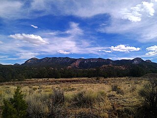
The Mogollon Mountains or Mogollon Range are a mountain range in Grant County and Catron County of southwestern New Mexico, in the Southwestern United States. They are primarily protected within the Gila National Forest.

Whitewater Baldy is the highest point of the Mogollon Mountains and the 3rd highest mountain in Southern New Mexico, after Sierra Blanca Peak and Lincoln County's Lookout Mountain. It is located in Catron County in the Gila Wilderness, part of the Gila National Forest. It lies about 15 miles (24 km) east of the town of Glenwood.

<span class="mw-page-title-main">San Mateo Mountains (Socorro County, New Mexico)</span> Landscape and mass

The San Mateo Mountains are a mountain range in Socorro County, in west-central New Mexico in the southwestern United States. The highest point in the range is West Blue Mountain, at 10,336 ft. The range runs roughly north–south and is about 40 miles (64 km) long. It lies about 25 miles (40 km) north-northwest of the town of Truth or Consequences and about 30 miles (48 km) southwest of Socorro. They should not be confused with the identically named range in Cibola and McKinley counties, north of this range.

<span class="mw-page-title-main">Glenwood, New Mexico</span> Census-designated place in New Mexico, United States

Glenwood is a census-designated place in Catron County, New Mexico, United States. As of the 2010 census it had a population of 143. The area was founded in 1878 as Bush Ranch. Located near the San Francisco River, Glenwood is 61 miles (98 km) northwest of Silver City on U.S. Route 180, and is 38 miles (61 km) south of Reserve.

Apache Creek is a census-designated place in Catron County, New Mexico, United States. As of the 2010 census it had a population of 67. Located 3 miles (5 km) northeast of Cruzville, it is situated at the confluence of Apache Creek and the Tularosa River. The Apache Creek Pueblo, also called the "Apache Creek Ruin", is near the town. It was listed by the New Mexico Historic Preservation Commission in 1969.

Cooney is a ghost town in Catron County, New Mexico, United States, east of Alma. Cooney was once home to gold and silver prospectors in the nearby Mogollon Mountains.

<span class="mw-page-title-main">U.S. Route 60 in New Mexico</span> Segment of American highway

U.S. Route 60 (US 60) is an east–west United States Highway within New Mexico. It begins at the Arizona state line and continues east to the Texas state line.

The El Caso Lookout Complex is located in the Gila National Forest north of Apache Creek, New Mexico. Built in 1934 by the Works Progress Administration, the complex was one of three New Deal-era forest fire lookouts built in Catron County. The other two are the Mangas Mountain Lookout Complex near Old Horse Springs and the Bearwallow Mountain Lookout Complex near Mogollon.

Datil National Forest was a United States National Forest established in western New Mexico by the U.S. Forest Service in 1908. It was merged into another and ceased in 1931.

<span class="mw-page-title-main">Mogollon-Datil volcanic field</span> Volcanic field in western New Mexico, United States

The Mogollon-Datil volcanic field is a large silicic volcanic field in western New Mexico. It is a part of an extensive Eocene to Oligocene volcanic event which includes the San Juan volcanic field in southwestern Colorado, the Trans-Pecos volcanic field in west Texas and north central Mexico, the Boot Heel volcanic field in the bootheel of southwestern New Mexico and adjacent areas of Arizona and Mexico; and the vast volcanic field of the Sierra Madre Occidental of western Mexico. The Mogollon-Datil volcanic field was formed in "four discrete pulses representing synchronized activity of two separate cauldron complexes".

Cooney's Tomb is a historic location near Alma, Catron County, New Mexico. Marked by a large boulder on the side of a roadway, it is the site where former Army Sergeant James C. Cooney was interred in 1880 after being killed by a group of Apaches.

<span class="mw-page-title-main">Datil Mountains</span>

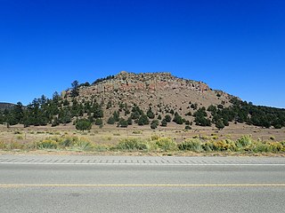
The Datil Mountains are a small range on the northern edge of the Mogollon-Datil volcanic field, just northwest of the Plains of San Agustin in the U.S. state of New Mexico. The range lies in Socorro and Catron Counties, north of the town of Datil, New Mexico and takes its name from the Spanish word for “date,” dating back over two hundred years. In The Place Names of New Mexico, Robert Julyan suggests two possible explanations for the name: 1) that “the seedpods of the broad-leafed yucca sufficiently resembled dates” or 2) “the Spanish applied the name to the fruit of the prickly pear cactus.” The area includes the major ridgeline of Madre Mountain, which is sacred ground to the Acoma, Laguna, and Zuni tribes, as well as several other unnamed peaks and ridges.

Quemado Independent Schools is a school district headquartered in Quemado, New Mexico, U.S. Shelby Perea of the Albuquerque Journal described the district, located in a rural area, as being "small".

References

  1. "Catron County, New Mexico". United States Census Bureau . Retrieved July 1, 2023.
  2. "Find a County". National Association of Counties. Archived from the original on May 31, 2011. Retrieved June 7, 2011.
  3. 1 2 (nd) National Register of Historic Places - Catron County, New Mexico. Retrieved June 13, 2007.
  4. "History of Socorro County" Archived February 11, 2012, at the Wayback Machine , Socorro Chamber of Commerce. Retrieved December 21, 2011.
  5. "2010 Census Gazetteer Files". United States Census Bureau. August 22, 2012. Archived from the original on January 1, 2015. Retrieved January 1, 2015.
  6. (nd) Chapter 4, Section IV. Native American Sacred Sites and the Department of Defense. Retrieved June 12, 2007.
  7. "U.S. Decennial Census". United States Census Bureau. Retrieved January 1, 2015.
  8. "Historical Census Browser". University of Virginia Library. Retrieved January 1, 2015.
  9. "Population of Counties by Decennial Census: 1900 to 1990". United States Census Bureau. Retrieved January 1, 2015.
  10. "Census 2000 PHC-T-4. Ranking Tables for Counties: 1990 and 2000" (PDF). United States Census Bureau. Archived (PDF) from the original on March 27, 2010. Retrieved January 1, 2015.
  11. "State & County QuickFacts". United States Census Bureau. Archived from the original on June 6, 2011. Retrieved September 27, 2013.
  12. "U.S. Census website". United States Census Bureau . Retrieved January 31, 2008.
  13. 1 2 3 "DP-1 Profile of General Population and Housing Characteristics: 2010 Demographic Profile Data". United States Census Bureau. Archived from the original on February 13, 2020. Retrieved January 24, 2016.
  14. "Population, Housing Units, Area, and Density: 2010 - County". United States Census Bureau. Archived from the original on February 13, 2020. Retrieved January 24, 2016.
  15. "DP02 SELECTED SOCIAL CHARACTERISTICS IN THE UNITED STATES – 2006–2010 American Community Survey 5-Year Estimates". United States Census Bureau. Archived from the original on February 13, 2020. Retrieved January 24, 2016.
  16. "DP03 SELECTED ECONOMIC CHARACTERISTICS – 2006–2010 American Community Survey 5-Year Estimates". United States Census Bureau. Archived from the original on February 13, 2020. Retrieved January 24, 2016.
  17. Padilla, L. (2003) "Bat Caving on the Plains of San Agustin" Archived June 30, 2011, at the Wayback Machine . Retrieved November 17, 2010.
  18. Leip, David. "Dave Leip's Atlas of U.S. Presidential Elections". uselectionatlas.org. Retrieved April 1, 2018.
  19. "2020 CENSUS - SCHOOL DISTRICT REFERENCE MAP: Catron County, NM" (PDF). U.S. Census Bureau. Archived (PDF) from the original on July 12, 2022. Retrieved July 12, 2022. - Text list

33°55′N108°25′W / 33.92°N 108.42°W / 33.92; -108.42