San Miguel County, New Mexico

Last updated

San Miguel County
San Miguel County New Mexico Court House.jpg
San Miguel County Courthouse in Las Vegas
Map of New Mexico highlighting San Miguel County.svg
Location within the U.S. state of New Mexico
New Mexico in United States.svg
New Mexico's location within the U.S.
Coordinates: 35°28′N104°50′W / 35.47°N 104.83°W / 35.47; -104.83
CountryFlag of the United States.svg United States
StateFlag of New Mexico.svg  New Mexico
FoundedJanuary 9, 1852
Named for San Miguel del Vado
Seat Las Vegas
Largest cityLas Vegas
Area
  Total4,736 sq mi (12,270 km2)
  Land4,716 sq mi (12,210 km2)
  Water20 sq mi (50 km2)  0.4%
Population
 (2020)
  Total27,201
  Density5.7/sq mi (2.2/km2)
Time zone UTC−7 (Mountain)
  Summer (DST) UTC−6 (MDT)
Congressional district 3rd
Website co.sanmiguel.nm.us

San Miguel County (Spanish : Condado de San Miguel) is a county in the U.S. state of New Mexico. As of the 2020 census, the population was 27,201. [1] Its county seat is Las Vegas. [2]

Contents

San Miguel County comprises the Las Vegas Micropolitan Statistical Area, which is also included in the Albuquerque–Santa Fe–Las Vegas combined statistical area.

Geography

According to the U.S. Census Bureau, the county has a total area of 4,736 square miles (12,270 km2), of which 4,716 square miles (12,210 km2) is land and 20 square miles (52 km2) (0.4%) is water. [3]

Adjacent counties

National protected areas

Demographics

Historical population
CensusPop.Note
1910 22,930
1920 22,867−0.3%
1930 23,6363.4%
1940 27,91018.1%
1950 26,512−5.0%
1960 23,468−11.5%
1970 21,951−6.5%
1980 22,7513.6%
1990 25,74313.2%
2000 30,12617.0%
2010 29,393−2.4%
2020 27,201−7.5%
U.S. Decennial Census [4]
1790–1960 [5] 1900–1990 [6]
1990–2000 [7] 2010 [8]

2000 census

As of the 2000 census, [9] there were 30,126 people, 11,134 households, and 7,537 families living in the county. The population density was 6 people per square mile (2.3 people/km2). There were 14,254 housing units at an average density of 3 units per square mile (1.2/km2). The racial makeup of the county was 56.22% White, 0.78% Black or African American, 1.82% Native American, 0.54% Asian, 0.08% Pacific Islander, 36.21% from other races, and 4.33% from two or more races. 77.96% of the population were Hispanic or Latino of any race.

There were 11,134 households, out of which 34.60% had children under the age of 18 living with them, 44.50% were married couples living together, 16.40% had a female householder with no husband present, and 32.30% were non-families. 26.60% of all households were made up of individuals, and 8.20% had someone living alone who was 65 years of age or older. The average household size was 2.58 and the average family size was 3.10.

In the county, the population was spread out, with 27.40% under the age of 18, 10.90% from 18 to 24, 27.00% from 25 to 44, 22.90% from 45 to 64, and 11.70% who were 65 years of age or older. The median age was 35 years. For every 100 females there were 96.70 males. For every 100 females age 18 and over, there were 93.90 males.

The median income for a household in the county was $26,524, and the median income for a family was $31,250. Males had a median income of $27,307 versus $22,588 for females. The per capita income for the county was $13,268. About 19.90% of families and 24.40% of the population were below the poverty line, including 27.80% of those under age 18 and 25.90% of those age 65 or over.

2010 census

As of the 2010 census, there were 29,393 people, 11,978 households, and 7,275 families living in the county. [10] The population density was 6.2 inhabitants per square mile (2.4/km2). There were 15,595 housing units at an average density of 3.3 units per square mile (1.3 units/km2). [11] The racial makeup of the county was 66.6% white, 1.7% American Indian, 1.4% black or African American, 0.8% Asian, 0.1% Pacific islander, 25.4% from other races, and 3.9% from two or more races. Those of Hispanic or Latino origin made up 76.8% of the population. [10] In terms of ancestry, 6.3% were German, 5.3% were English, and 1.6% were American. [12]

Of the 11,978 households, 28.8% had children under the age of 18 living with them, 38.6% were married couples living together, 14.9% had a female householder with no husband present, 39.3% were non-families, and 32.5% of all households were made up of individuals. The average household size was 2.34 and the average family size was 2.95. The median age was 40.7 years. [10]

The median income for a household in the county was $32,213 and the median income for a family was $42,888. Males had a median income of $35,176 versus $28,351 for females. The per capita income for the county was $18,508. About 15.7% of families and 24.8% of the population were below the poverty line, including 29.6% of those under age 18 and 22.7% of those age 65 or over. [13]

Communities

City

Villages

Census-designated places

Other communities

Ghost town

Education

Montezuma Castle is on the campus of the United World College of the American West Mcastle2003.jpg
Montezuma Castle is on the campus of the United World College of the American West

Public school districts include: [14]

Tertiary education institutions in San Miguel County include:

Native American Preparatory School, a private school, was in operation in the county until 2002. [15]

Notable people

Politics

San Miguel County is heavily Democratic. The last time it voted Republican for president was 1956, and since 1992 no Republican has cracked 30% of the vote.

United States presidential election results for San Miguel County, New Mexico [16]
Year Republican Democratic Third party
No.%No.%No.%
2020 3,42129.67%7,88868.41%2221.93%
2016 2,31321.51%7,28567.76%1,15310.72%
2012 2,30320.01%8,85076.90%3563.09%
2008 2,47819.15%10,32079.75%1431.11%
2004 3,31327.34%8,68371.67%1200.99%
2000 2,21524.18%6,54071.39%4064.43%
1996 1,93820.09%6,99572.51%7147.40%
1992 2,18323.26%6,18665.90%1,01810.84%
1988 2,76330.62%6,13167.95%1291.43%
1984 3,48539.38%5,22759.06%1381.56%
1980 3,29239.34%4,51453.94%5636.73%
1976 3,16237.17%5,20461.17%1411.66%
1972 4,43447.71%4,66350.18%1962.11%
1968 4,02748.12%4,08848.85%2533.02%
1964 2,71431.91%5,76767.81%240.28%
1960 3,98841.92%5,52058.02%60.06%
1956 5,08355.86%4,01444.11%30.03%
1952 5,36054.59%4,45145.34%70.07%
1948 4,65548.34%4,95351.44%210.22%
1944 4,01446.13%4,68453.83%40.05%
1940 4,88244.61%6,05455.32%70.06%
1936 4,69743.07%6,19956.84%100.09%
1932 5,36451.28%5,07648.53%200.19%
1928 5,18459.26%3,56040.70%40.05%
1924 3,89450.56%3,54346.00%2653.44%
1920 5,53558.11%3,99041.89%00.00%
1916 2,93256.37%2,23142.90%380.73%
1912 2,47955.67%1,74039.07%2345.25%

See also

Related Research Articles

<span class="mw-page-title-main">Greenlee County, Arizona</span> County in Arizona, United States

Greenlee County is a county in the southeastern part of the U.S. state of Arizona. As of the 2020 census, the population was 9,563, making it Arizona's least populous county. The county seat is Clifton.

<span class="mw-page-title-main">Santa Cruz County, Arizona</span> County in Arizona, United States

Santa Cruz is a county in southern Arizona, United States. As of the 2020 census, the population is 47,669. The county seat is Nogales. The county was established in 1899. It borders Pima County to the north and west, Cochise County to the east, and the Mexican state of Sonora to the south.

<span class="mw-page-title-main">Sierra County, New Mexico</span> County in New Mexico, United States

Sierra County is a county located in the U.S. state of New Mexico. As of the 2020 Census, the population was 11,576. Its county seat is Truth or Consequences.

<span class="mw-page-title-main">Santa Fe County, New Mexico</span> County in New Mexico, United States

Santa Fe County is located in the U.S. state of New Mexico. As of the 2020 census, the population was 154,823, making it New Mexico's third-most populous county, after Bernalillo County and Doña Ana County. Its county seat is Santa Fe, the state capital.

<span class="mw-page-title-main">Sandoval County, New Mexico</span> County in New Mexico, United States

Sandoval County is located in the U.S. state of New Mexico. As of the 2020 census, the population was 148,834, making it the fourth-most populous county in New Mexico. The county seat is Bernalillo.

<span class="mw-page-title-main">San Juan County, New Mexico</span> County in New Mexico, United States

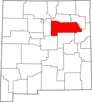
San Juan County is located in the U.S. state of New Mexico. As of the 2020 census, the population was 121,661 making it the fifth-most populous county in New Mexico. Its county seat is Aztec. The county was created in 1887.

<span class="mw-page-title-main">Rio Arriba County, New Mexico</span> County in New Mexico, United States

Rio Arriba County is a county in the U.S. state of New Mexico. As of the 2020 census, the population was 40,363. Its county seat is Tierra Amarilla. Its northern border is the Colorado state line.

<span class="mw-page-title-main">Quay County, New Mexico</span> County in New Mexico, United States

Quay County is a county in the state of New Mexico. As of the 2020 U.S. census, the population was 8,746. Its county seat is Tucumcari. The county was named for Pennsylvania senator Matthew Quay, who supported statehood for New Mexico. Its eastern border is the Texas state line, approximately 103.04 degrees west longitude.

<span class="mw-page-title-main">Mora County, New Mexico</span> County in New Mexico, United States

Mora County is a county in the U.S. state of New Mexico. As of the 2020 census, the population was 4,189. Its county seat is the census-designated place (CDP) Mora. The county has another CDP, Watrous, a village, Wagon Mound, and 12 smaller unincorporated settlements. Mora became a formal county in the US, in what was then the New Mexico Territory, on February 1, 1860. Ecclesiastically, the county is within the Roman Catholic Archdiocese of Santa Fe. County population peaked at approximately 14,000 circa 1920, declining to about 4,000 to 5,000 since the 1970s; the 2018 estimate was 4,506.

<span class="mw-page-title-main">Harding County, New Mexico</span> County in New Mexico, United States

Harding County is a county in the U.S. state of New Mexico. As of the 2020 census, the population was 657, making it the least populous county in the state, and the 13th-smallest county by population in the United States. Its county seat is Mosquero. The county is named for United States President Warren G. Harding, and was created on the day of his inauguration as president on March 4, 1921, making him the most recent president to have a county in any state named after him.

<span class="mw-page-title-main">Guadalupe County, New Mexico</span> County in New Mexico, United States

Guadalupe County is a county in the U.S. state of New Mexico. As of the 2020 census, the population was 4,452. Its county seat is Santa Rosa.

<span class="mw-page-title-main">Eddy County, New Mexico</span> County in New Mexico, United States

Eddy County is a county located in the U.S. state of New Mexico. As of the 2020 census, the population was 62,314. Its county seat and largest city is Carlsbad. The county was created in 1891 and later organized in 1892. It is north of the Texas state line.

<span class="mw-page-title-main">Colfax County, New Mexico</span> County in New Mexico, United States

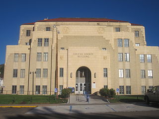
Colfax County is a county in the U.S. state of New Mexico. As of the 2020 census, the population was 12,387. Its county seat is Raton. It is south from the Colorado state line. This county was named for Schuyler Colfax (1823–1885), seventeenth Vice President of the United States under U.S. President Ulysses S. Grant.

<span class="mw-page-title-main">Cibola County, New Mexico</span> County in New Mexico, United States

Cibola County is a county in the U.S. state of New Mexico. As of the 2020 census, the population was 27,172. Its county seat is Grants. It is New Mexico's youngest county, and the third youngest county in the United States, created on June 19, 1981, from the westernmost four-fifths of the formerly much larger Valencia County.

<span class="mw-page-title-main">Costilla County, Colorado</span> County in Colorado, United States

Costilla County is a county located in the U.S. state of Colorado. As of the 2020 census, the population was 3,499. The county seat is San Luis, the oldest continuously occupied town in Colorado.

<span class="mw-page-title-main">Dexter, New Mexico</span> Town in New Mexico, United States

Dexter is a town in Chaves County, New Mexico, United States. The population was 1,266 at the time of the 2010 census.

<span class="mw-page-title-main">Pecos, New Mexico</span> Village in New Mexico, United States

Pecos is a village in San Miguel County, New Mexico, United States. The population was 1,392 at the 2010 census, shrinking slower than other parts of San Miguel County, partly because Pecos is within commuting distance of Santa Fe. The village is built along the Pecos River, which flows from the north out of the Santa Fe National Forest. Notable locations nearby include Pecos National Historical Park, Glorieta Pass, Pecos Benedictine Monastery, and Lisboa Springs Trout Hatchery. It is also an entry point for hunting, fishing, hiking and camping in the Pecos Wilderness. The closest metropolitan area is the Santa Fe metropolitan area, approximately 26 miles (42 km) to the west.

Camp A Lake is an unorganized territory in Saint Louis County, Minnesota, United States. The population was 16 at the 2000 census.

<span class="mw-page-title-main">Mosquero, New Mexico</span> Village in New Mexico, United States

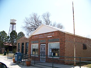
Mosquero is a village in Harding and San Miguel counties in the U.S. state of New Mexico. The population was 93 at the 2010 census, down from 120 in 2000. It is the county seat of Harding County; only a small portion of the village extends into San Miguel County.

<span class="mw-page-title-main">Doña Ana County, New Mexico</span> County in New Mexico, United States

Doña Ana County is located in the southern part of the State of New Mexico, United States. As of the 2020 U.S. Census, its population was 219,561, which makes it the second-most populated county in New Mexico. Its county seat is Las Cruces, the second-most populous municipality in New Mexico after Albuquerque, with 111,385 as of the 2020 U.S. Census.

References

  1. "San Miguel County, New Mexico". United States Census Bureau . Retrieved July 3, 2023.
  2. "Find a County". National Association of Counties. Retrieved June 7, 2011.
  3. "2010 Census Gazetteer Files". United States Census Bureau. August 22, 2012. Archived from the original on January 1, 2015. Retrieved January 2, 2015.
  4. "U.S. Decennial Census". United States Census Bureau. Retrieved January 2, 2015.
  5. "Historical Census Browser". University of Virginia Library. Retrieved January 2, 2015.
  6. "Population of Counties by Decennial Census: 1900 to 1990". United States Census Bureau. Retrieved January 2, 2015.
  7. "Census 2000 PHC-T-4. Ranking Tables for Counties: 1990 and 2000" (PDF). United States Census Bureau. Archived (PDF) from the original on March 27, 2010. Retrieved January 2, 2015.
  8. "State & County QuickFacts". United States Census Bureau. Archived from the original on July 28, 2011. Retrieved September 30, 2013.
  9. "U.S. Census website". United States Census Bureau . Retrieved January 31, 2008.
  10. 1 2 3 "DP-1 Profile of General Population and Housing Characteristics: 2010 Demographic Profile Data". United States Census Bureau. Archived from the original on February 13, 2020. Retrieved January 24, 2016.
  11. "Population, Housing Units, Area, and Density: 2010 – County". United States Census Bureau. Archived from the original on February 13, 2020. Retrieved January 24, 2016.
  12. "DP02 SELECTED SOCIAL CHARACTERISTICS IN THE UNITED STATES – 2006–2010 American Community Survey 5-Year Estimates". United States Census Bureau. Archived from the original on February 13, 2020. Retrieved January 24, 2016.
  13. "DP03 SELECTED ECONOMIC CHARACTERISTICS – 2006–2010 American Community Survey 5-Year Estimates". United States Census Bureau. Archived from the original on February 13, 2020. Retrieved January 24, 2016.
  14. "2020 CENSUS – SCHOOL DISTRICT REFERENCE MAP: San Miguel County, NM" (PDF). U.S. Census Bureau. Archived (PDF) from the original on July 12, 2022. Retrieved July 12, 2022.Text list
  15. Boyle, Christina (May 26, 2002). "Native American Preparatory School Graduates its Last Class". The Santa Fe New Mexican . p. B-1, B-4. – Clipping of first page and of second page at Newspapers.com. reprinted in Canku Ota, June 1, 2002.
  16. Leip, David. "Dave Leip's Atlas of U.S. Presidential Elections". uselectionatlas.org. Retrieved April 2, 2018.

35°28′N104°50′W / 35.47°N 104.83°W / 35.47; -104.83