Chaves County, New Mexico

Last updated

Chaves County
Chaves County New Mexico Court House west side.jpg
Chaves County New Mexico logo.png
Map of New Mexico highlighting Chaves County.svg
Location within the U.S. state of New Mexico
New Mexico in United States.svg
New Mexico's location within the U.S.
Coordinates: 33°22′N104°28′W / 33.36°N 104.47°W / 33.36; -104.47
CountryFlag of the United States.svg United States
StateFlag of New Mexico.svg  New Mexico
FoundedFebruary 25, 1889
Named for José Francisco Chaves
Seat Roswell
Largest cityRoswell
Area
  Total6,075 sq mi (15,730 km2)
  Land6,065 sq mi (15,710 km2)
  Water9.8 sq mi (25 km2)  0.2%
Population
 (2020)
  Total65,157
  Density11/sq mi (4/km2)
Time zone UTC−7 (Mountain)
  Summer (DST) UTC−6 (MDT)
Congressional districts 1st, 2nd, 3rd
Website co.chaves.nm.us

Chaves County is a county in New Mexico, United States. As of the 2020 census, the population was 65,157. [1] Its county seat is Roswell. [2] Chaves County was named for Colonel Jose Francisco Chaves, a military leader there during the Civil War and later in Navajo campaigns. The county was created by the New Mexico Territorial Legislature on February 25, 1889, out of land from Lincoln County.

Contents

Chaves County comprises the Roswell, New Mexico Micropolitan Statistical Area.

Geography

According to the U.S. Census Bureau, the county has a total area of 6,075 square miles (15,730 km2), of which 6,065 square miles (15,710 km2) is land and 9.8 square miles (25 km2) (0.2%) is water. [3] It is the fourth-largest county in New Mexico by area.

Adjacent counties

National protected areas

Demographics

Historical population
CensusPop.Note
1910 16,850
1920 12,075−28.3%
1930 19,54961.9%
1940 23,98022.7%
1950 40,60569.3%
1960 57,64942.0%
1970 43,335−24.8%
1980 51,10317.9%
1990 57,84913.2%
2000 61,3826.1%
2010 65,6456.9%
2020 65,157−0.7%
U.S. Decennial Census [4]
1790-1960 [5] 1900-1990 [6]
1990-2000 [7] 2010 [8]

2000 census

As of the 2000 census, [9] there were 61,382 people, 22,561 households, and 16,085 families living in the county. The population density was 10 people per square mile (3.9 people/km2). There were 25,647 housing units at an average density of 4 units per square mile (1.5/km2). The racial makeup of the county was 71.95% White, 1.97% Black or African American, 1.13% Native American, 0.53% Asian, 0.06% Pacific Islander, 21.25% from other races, and 3.12% from two or more races. 43.83% of the population were Hispanic or Latino of any race.

There were 22,561 households, out of which 35.60% had children under the age of 18 living with them, 52.70% were married couples living together, 13.70% had a female householder with no husband present, and 28.70% were non-families. 24.80% of all households were made up of individuals, and 11.60% had someone living alone who was 65 years of age or older. The average household size was 2.66 and the average family size was 3.17.

In the county, the population was spread out, with 29.10% under the age of 18, 9.40% from 18 to 24, 25.30% from 25 to 44, 21.50% from 45 to 64, and 14.70% who were 65 years of age or older. The median age was 35 years. For every 100 females there were 95.90 males. For every 100 females age 18 and over, there were 91.60 males.

The median income for a household in the county was $28,513, and the median income for a family was $32,532. Males had a median income of $26,896 versus $21,205 for females. The per capita income for the county was $14,990. About 17.60% of families and 21.30% of the population were below the poverty line, including 29.10% of those under age 18 and 13.90% of those age 65 or over.

2010 census

As of the 2010 census, there were 65,645 people, 23,691 households, and 16,646 families living in the county. [10] The population density was 10.8 inhabitants per square mile (4.2 inhabitants/km2). There were 26,697 housing units at an average density of 4.4 units per square mile (1.7 units/km2). [11] The racial makeup of the county was 70.9% white, 2.0% black or African American, 1.2% American Indian, 0.6% Asian, 0.1% Pacific islander, 21.9% from other races, and 3.2% from two or more races. Those of Hispanic or Latino origin made up 52.0% of the population. [10] In terms of ancestry, 10.1% were German, 9.3% were Irish, 8.5% were English, and 4.6% were American. [12]

Of the 23,691 households, 37.7% had children under the age of 18 living with them, 48.9% were married couples living together, 14.9% had a female householder with no husband present, 29.7% were non-families, and 25.2% of all households were made up of individuals. The average household size was 2.70 and the average family size was 3.22. The median age was 34.7 years. [10]

The median income for a household in the county was $37,524 and the median income for a family was $43,464. Males had a median income of $37,573 versus $26,250 for females. The per capita income for the county was $18,504. About 15.9% of families and 21.0% of the population were below the poverty line, including 27.1% of those under age 18 and 14.6% of those age 65 or over. [13]

Politics

Chaves County is a Republican stronghold. No Democratic presidential candidate has won Chaves County since Lyndon Johnson's landslide victory of 1964. Even in that election, Johnson took Chaves County by only 1.3 percent. [14]

United States presidential election results for Chaves County, New Mexico [15]
Year Republican Democratic Third party
No.%No.%No.%
2020 15,65669.76%6,38128.43%4061.81%
2016 12,87263.50%5,53427.30%1,8659.20%
2012 13,08864.50%6,60432.54%6002.96%
2008 13,65161.74%8,19737.07%2641.19%
2004 14,77368.06%6,72630.99%2060.95%
2000 11,37862.69%6,34034.93%4312.37%
1996 9,99153.95%7,01437.87%1,5148.18%
1992 8,87246.95%6,36033.65%3,66619.40%
1988 13,36765.84%6,73033.15%2061.01%
1984 15,24873.37%5,33225.66%2020.97%
1980 12,50267.24%5,35028.77%7423.99%
1976 10,63159.26%7,13939.79%1700.95%
1972 11,49370.87%4,29626.49%4272.63%
1968 8,86663.61%3,61225.91%1,46010.47%
1964 8,41949.20%8,65050.55%430.25%
1960 9,08959.05%6,21240.36%910.59%
1956 7,53863.37%4,27035.89%880.74%
1952 7,01863.92%3,88035.34%810.74%
1948 3,12340.43%4,56959.15%330.43%
1944 3,14948.33%3,35051.41%170.26%
1940 2,98140.84%4,30458.97%140.19%
1936 2,50535.70%4,39462.62%1181.68%
1932 1,83028.95%4,25767.34%2353.72%
1928 3,12469.48%1,36430.34%80.18%
1924 1,51939.40%2,16856.24%1684.36%
1920 1,76545.54%2,08053.66%310.80%
1916 86225.90%2,27568.36%1915.74%
1912 46518.24%1,33952.53%74529.23%

Communities

City

Towns

Census-designated place

Unincorporated communities

Education

School districts include: [16]

Notable people

See also

Related Research Articles

<span class="mw-page-title-main">Union County, New Mexico</span> County in New Mexico, United States

Union County is the northeasternmost county in the U.S. state of New Mexico. As of the 2020 census, the population was 4,079, making it the fourth-least populous county in New Mexico. Its county seat is Clayton. The county was formed in 1894. Union County borders Colorado to the north, and Oklahoma and Texas to the east.

<span class="mw-page-title-main">Taos County, New Mexico</span> County in New Mexico, United States

Taos County is a county in the U.S. state of New Mexico. As of the 2020 census, the population was 34,489. Its county seat is Taos. The county was formed in 1852 as one of the original nine counties in New Mexico Territory.

<span class="mw-page-title-main">San Juan County, New Mexico</span> County in New Mexico, United States

San Juan County is located in the U.S. state of New Mexico. As of the 2020 census, the population was 121,661 making it the fifth-most populous county in New Mexico. Its county seat is Aztec. The county was created in 1887.

<span class="mw-page-title-main">Roosevelt County, New Mexico</span> County in New Mexico, United States

Roosevelt County is a county located in the U.S. state of New Mexico. As of the 2020 census, the population was 19,191. Its county seat is Portales. The county was created in 1903 from Chaves and Guadalupe counties and named for the then-current President of the United States, Theodore Roosevelt. The county's eastern border is the Texas state line.

<span class="mw-page-title-main">Luna County, New Mexico</span> County in New Mexico, United States

Luna County(Spanish: Condado de Luna) is a county located in the U.S. state of New Mexico. As of the 2020 census, the population was 25,427. Its county seat is Deming. This county abuts the Mexican border. Luna County comprises the Deming, NM Micropolitan Statistical Area.

<span class="mw-page-title-main">Lincoln County, New Mexico</span> County in New Mexico, United States

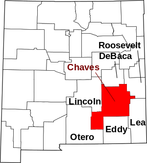
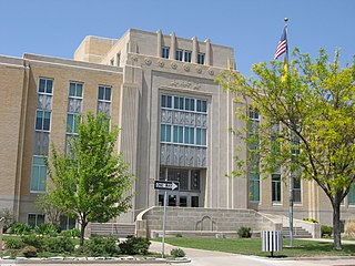
Lincoln County is a county in the U.S. state of New Mexico. As of the 2020 census, the population was 20,269. Its county seat is Carrizozo, while its largest community is Ruidoso.

<span class="mw-page-title-main">Grant County, New Mexico</span> County in New Mexico, United States

Grant County is a county located in the U.S. state of New Mexico. At the 2020 census, the population was 28,185. Its county seat is Silver City. The county was founded in 1868 and named for Ulysses S. Grant, the 18th President of the United States.

<span class="mw-page-title-main">Eddy County, New Mexico</span> County in New Mexico, United States

Eddy County is a county located in the U.S. state of New Mexico. As of the 2020 census, the population was 62,314. Its county seat and largest city is Carlsbad. The county was created in 1891 and later organized in 1892. It is north of the Texas state line.

<span class="mw-page-title-main">Penobscot County, Maine</span> County in Maine, United States

Penobscot County is a county in the U.S. state of Maine, named for the Penobscot people in Wabanakik. As of the 2020 census, the population was 152,199, making it the third-most-populous county in Maine. Its county seat is Bangor. The county was established on February 15, 1816, from part of Hancock County when the area was still part of Massachusetts. Penobscot County is home to the University of Maine.

<span class="mw-page-title-main">Oxford County, Maine</span> County in Maine, United States

Oxford County is a county in the state of Maine, United States. As of the 2020 Census, the county had a population of 57,777. Its county seat is the town of Paris. The county was formed on March 4, 1805, by the Massachusetts General Court in the Maine District from northerly portions of York and Cumberland counties. It borders the Canadian province of Quebec. Part of Oxford County is included in the Lewiston-Auburn, Maine metropolitan New England City and Town Area while a different part of Oxford County is included in the Portland-South Portland-Biddeford, Maine metropolitan New England City and Town Area.

<span class="mw-page-title-main">Payette County, Idaho</span> County in Idaho, United States

Payette County is a county located in Idaho in the United States of America. As of the 2020 census, the population was 25,386. The county seat and largest city is Payette.

<span class="mw-page-title-main">Custer County, Idaho</span> County in Idaho, United States

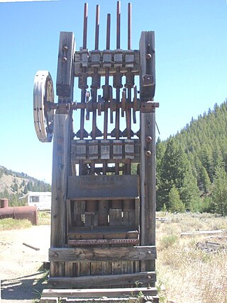
Custer County is a rural mountain county in the center of the U.S. state of Idaho. As of the 2020 census, the population was 4,275, making it the fifth-least populous county in Idaho. The county seat is Challis. Established in 1881, the county was named for the General Custer Mine, where gold was discovered five years earlier. Custer County relies on ranching, mining, and tourism as its main resources.

<span class="mw-page-title-main">Martinsburg, Missouri</span> City in Missouri, United States

Martinsburg is a city in Audrain County, Missouri, United States. The population was 304 at the 2010 census.

<span class="mw-page-title-main">Dexter, New Mexico</span> Town in New Mexico, United States

Dexter is a town in Chaves County, New Mexico, United States. The population was 1,266 at the time of the 2010 census.

<span class="mw-page-title-main">Hagerman, New Mexico</span> Town in New Mexico, United States

Hagerman is a town in Chaves County, New Mexico, United States. The population was 1,251 at the 2010 census.

<span class="mw-page-title-main">Lake Arthur, New Mexico</span> Town in New Mexico, United States

Lake Arthur is a town in Chaves County, New Mexico, United States. The population was 436 at the 2010 census.

<span class="mw-page-title-main">Skyline-Ganipa, New Mexico</span> Census-designated place in New Mexico, United States

Skyline-Ganipa is a census-designated place (CDP) in Cibola County, New Mexico, United States. The population was 1,224 at the 2010 census.

<span class="mw-page-title-main">Tatum, New Mexico</span> Town in New Mexico, United States

Tatum is a town in Lea County, New Mexico, United States. The population was 798 at the 2010 census, up from 683 in 2000.

<span class="mw-page-title-main">Corona, New Mexico</span> Village in New Mexico, United States

Corona is a village in Lincoln County, New Mexico, United States, located along U.S. Route 54. The population was 172 at the time of the 2010 census.

<span class="mw-page-title-main">De Baca County, New Mexico</span> County in New Mexico, United States

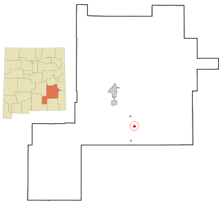
De Baca County is a county in the U.S. state of New Mexico. As of the 2020 census, the population was 1,698, making it New Mexico's second-least populous county. Its county seat is Fort Sumner. The county is named for Ezequiel Cabeza De Baca, the second elected Governor of New Mexico.

References

  1. "Chaves County, New Mexico". United States Census Bureau . Retrieved July 1, 2023.
  2. "Find a County". National Association of Counties. Archived from the original on May 31, 2011. Retrieved June 7, 2011.
  3. "2010 Census Gazetteer Files". United States Census Bureau. August 22, 2012. Archived from the original on January 1, 2015. Retrieved January 1, 2015.
  4. "U.S. Decennial Census". United States Census Bureau. Retrieved January 1, 2015.
  5. "Historical Census Browser". University of Virginia Library. Archived from the original on August 11, 2012. Retrieved January 1, 2015.
  6. "Population of Counties by Decennial Census: 1900 to 1990". United States Census Bureau. Retrieved January 1, 2015.
  7. "Census 2000 PHC-T-4. Ranking Tables for Counties: 1990 and 2000" (PDF). United States Census Bureau. Archived (PDF) from the original on March 27, 2010. Retrieved January 1, 2015.
  8. "State & County QuickFacts". United States Census Bureau. Archived from the original on June 6, 2011. Retrieved September 27, 2013.
  9. "U.S. Census website". United States Census Bureau . Retrieved January 31, 2008.
  10. 1 2 3 "DP-1 Profile of General Population and Housing Characteristics: 2010 Demographic Profile Data". United States Census Bureau. Archived from the original on February 13, 2020. Retrieved January 24, 2016.
  11. "Population, Housing Units, Area, and Density: 2010 - County". United States Census Bureau. Archived from the original on February 13, 2020. Retrieved January 24, 2016.
  12. "DP02 SELECTED SOCIAL CHARACTERISTICS IN THE UNITED STATES – 2006-2010 American Community Survey 5-Year Estimates". United States Census Bureau. Archived from the original on February 13, 2020. Retrieved January 24, 2016.
  13. "DP03 SELECTED ECONOMIC CHARACTERISTICS – 2006-2010 American Community Survey 5-Year Estimates". United States Census Bureau. Archived from the original on February 13, 2020. Retrieved January 24, 2016.
  14. "Dave Leip's Atlas of U.S. Presidential Elections".
  15. Leip, David. "Dave Leip's Atlas of U.S. Presidential Elections". uselectionatlas.org. Retrieved April 1, 2018.
  16. "2020 CENSUS - SCHOOL DISTRICT REFERENCE MAP: Chaves County, NM" (PDF). U.S. Census Bureau. Archived (PDF) from the original on June 28, 2022. Retrieved June 28, 2022. - Text list
Template:Attached KML/Chaves County, New Mexico
KML is from Wikidata

Commons-logo.svg Media related to Chaves County, New Mexico at Wikimedia Commons

33°22′N104°28′W / 33.36°N 104.47°W / 33.36; -104.47