McKinley County, New Mexico

Last updated

McKinley County
McKinley County New Mexico Court House.jpg
Map of New Mexico highlighting McKinley County.svg
Location within the U.S. state of New Mexico
New Mexico in United States.svg
New Mexico's location within the U.S.
Coordinates: 35°35′N108°16′W / 35.58°N 108.26°W / 35.58; -108.26
CountryFlag of the United States.svg United States
StateFlag of New Mexico.svg  New Mexico
FoundedJanuary 1, 1901
Named for William McKinley
Seat Gallup
Largest cityGallup
Area
  Total5,455.5 sq mi (14,130 km2)
  Land5,450 sq mi (14,100 km2)
  Water5.5 sq mi (14 km2)  0.1%
Population
 (2020)
  Total72,902
  Density13/sq mi (5.2/km2)
Time zone UTC−7 (Mountain)
  Summer (DST) UTC−6 (MDT)
Congressional districts 2nd, 3rd
Website www.co.mckinley.nm.us

McKinley County is a county in the northwestern section of the U.S. state of New Mexico. As of the 2020 United States Census, its population was 72,902. [1] Its county seat is Gallup. [2] The county was created in 1901 and named for President William McKinley. [3]

Contents

McKinley County is Gallup's micropolitan statistical area.

Geography

According to the U.S. Census Bureau, the county has a total area of 5,455 square miles (14,130 km2), of which 5.5 sq mi (14 km2) (0.1%) are covered by water. [4]

Adjacent counties

Major highways

National protected areas

Demographics

Census-designated places

For purposes of census-data collection, organization and analysis, the United States Census Bureau has devised 44 census-designated places since 1980 within McKinley County.

Historical population
CensusPop.Note
1910 12,963
1920 13,7315.9%
1930 20,64350.3%
1940 23,64114.5%
1950 27,45116.1%
1960 37,20935.5%
1970 43,20816.1%
1980 56,44930.6%
1990 60,6867.5%
2000 74,79823.3%
2010 71,492−4.4%
2020 72,9022.0%
U.S. Decennial Census [5]
1790–1960 [6] 1900–1990 [7]
1990–2000 [8] 2010 [9]

2000 census

As of the 2000 census, [10] 74,798 people, 21,476 households, and 16,686 families were living in the county. The population density was 14 people per square mile (5.4 people/km2). The 26,718 housing units had an average density of 5 units per square mile (1.9 units/km2). The racial makeup of the county was 74.72% Native American, 16.39% White, 0.46% Asian, 0.40% African American, 0.04% Pacific Islander, 5.47% from other races, and 2.52% from two or more races. About 12.40% of the population were Hispanics or Latinos of any race.

Of the 21,476 households, 46.0% had children under 18 living with them, 47.7% were married couples living together, 22.7% had a female householder with no husband present, and 22.3% were not families. About 19.5% of all households were made up of individuals, and 5.3% had someone living alone who was 65 or older. The average household size was 3.44, and the average family size was 3.99.

In the county, the age distribution was 38.0% under 18, 9.7% from 18 to 24, 27.8% from 25 to 44, 17.6% from 45 to 64, and 6.9% who were 65 or older. The median age was 27 years. For every 100 females, there were 93.50 males. For every 100.0 females 18 and over, there were 89.3 males.

The median income for a household in the county was $25,005, and for a family was $26,806. Males had a median income of $26,963 versus $21,014 for females. The per capita income for the county was $9,872. About 31.9% of families and 36.1% of the population were below the poverty line, including 42.3% of those under 18 and 31.5% of those 65 or over. The county's per capita income makes it one of the poorest counties in the United States.

McKinley County is one of only 38 county-level census divisions of the United States where the most spoken language is not English and one of only three where it is neither English nor Spanish; 45.75% of the population speak Navajo at home, followed by English at 38.87%, Zuñi at 9.03%, and Spanish at 5.72%.

2010 census

As of the 2010 census, 71,492 people, 21,968 households, and 16,219 families resided in the county. [11] The population density was 13.1 inhabitants per square mile (5.1/km2). The 25,813 housing units had an average density of 4.7/sq mi (1.8/km2). [12] The racial makeup of the county was 75.5% Native American, 15.2% White, 0.8% Asian, 0.5% Black or African American, 4.9% from other races, and 3.1% from two or more races. Those of Hispanic or Latino origin made up 13.3% of the population. [11]

Of the 21,968 households, 46.2% had children under 18 living with them, 40.8% were married couples living together, 24.5% had a female householder with no husband present, 26.2% were not families, and 22.4% of all households were made up of individuals. The average household size was 3.22, and the average family size was 3.82. The median age was 30.7 years. [11]

The median income for a household in the county was $31,335 and for a family was $37,345. Males had a median income of $31,527 versus $26,236 for females. The per capita income for the county was $12,932. About 26.6% of families and 33.4% of the population were below the poverty line, including 43.0% of those under 18 and 31.3% of those 65 or over. [13]

Communities

City

Unincorporated communities

Education

Locally controlled public schools in most of McKinley County are run by Gallup-McKinley County Schools, the local school district, and include Crownpoint High School, Gallup Central High School, Gallup High School, Hiroshi Miyamura High School, Navajo Pine High School, Ramah Middle / High School, Thoreau High School, Tohatchi High School, and Tse Yi Gai High School. [14] Areas in and around the Zuni reservation are in the Zuni Public School District, [15] which operates Zuni High School.

Two Bureau of Indian Education (BIE) boarding schools are in the Fort Wingate area: Wingate Elementary School, [16] and Wingate High School. The BIE also operates a K-8 school, Pueblo Pintado Community School, in Pueblo Pintado, [17] and a K-6 school, Baca /Dlo'Ay Azhi Community School. [18] Additionally, a tribal school affiliated with the BIE, Ch'ooshgai Community School, is located in Tohatchi. [19]

Politics

During its early history from 1912 to 1928, McKinley County voted for the Republican candidate in every presidential election. From 1932 onward, the county, with its large Native American majority, has backed Democratic candidates in all but three presidential elections that were national landslides for the Republican Party.

United States presidential election results for McKinley County, New Mexico [20]
Year Republican Democratic Third party
No.%No.%No.%
2020 7,80129.45%18,02968.07%6562.48%
2016 5,10423.52%13,57662.55%3,02313.93%
2012 5,54625.29%15,84172.24%5422.47%
2008 6,38227.50%16,57271.41%2531.09%
2004 7,35135.64%13,05163.28%2211.07%
2000 5,07031.93%10,28164.75%5283.33%
1996 4,47028.79%10,12465.21%9326.00%
1992 4,72030.39%9,40560.56%1,4069.05%
1988 5,69436.81%9,59562.04%1781.15%
1984 6,55744.78%7,91554.05%1711.17%
1980 7,32956.66%4,86937.64%7365.69%
1976 4,61739.83%6,85659.14%1201.04%
1972 5,36649.74%5,12447.49%2992.77%
1968 4,37645.71%4,49146.91%7067.37%
1964 2,96529.65%6,91369.13%1221.22%
1960 4,26243.08%5,59956.60%320.32%
1956 4,45056.97%3,33142.64%300.38%
1952 3,09149.80%3,09749.90%190.31%
1948 2,10940.96%2,99558.17%450.87%
1944 1,54741.14%2,21058.78%30.08%
1940 1,70140.19%2,52559.66%60.14%
1936 1,40435.60%2,52664.05%140.35%
1932 1,37339.35%2,09660.07%200.57%
1928 2,07562.22%1,24737.39%130.39%
1924 1,65351.24%1,15035.65%42313.11%
1920 1,52560.02%98938.92%271.06%
1916 66954.57%55044.86%70.57%
1912 26436.07%22430.60%24433.33%

See also

Related Research Articles

<span class="mw-page-title-main">Sandoval County, New Mexico</span> County in New Mexico, United States

Sandoval County is located in the U.S. state of New Mexico. As of the 2020 census, the population was 148,834, making it the fourth-most populous county in New Mexico. The county seat is Bernalillo.

<span class="mw-page-title-main">Pinehill, New Mexico</span> Census-designated place in New Mexico, United States

Pinehill or Pine Hill is a census-designated place in Cibola County, New Mexico, United States. It is located on the Ramah Navajo Indian Reservation. The population was 88 at the 2010 census. The location of the CDP in 2010 had become the location of the Mountain View CDP as of the 2020 census, while a new CDP named "Pinehill" was listed 8 miles (13 km) further south, at a point 4 miles (6 km) southeast of Candy Kitchen.

<span class="mw-page-title-main">Black Rock, New Mexico</span> Census-designated place in McKinley County, New Mexico, United States

Black Rock is an unincorporated community and a census-designated place in McKinley County, New Mexico, United States. The population was 1,323 at the 2010 census.

<span class="mw-page-title-main">Brimhall Nizhoni, New Mexico</span> Census-designated place in McKinley County, New Mexico, United States

Brimhall Nizhoni is a census-designated place (CDP) in McKinley County, New Mexico, United States. The population was 199 at the 2010 census. The Navajo Coyote Canyon Chapter House is located in Brimhall.

<span class="mw-page-title-main">Crownpoint, New Mexico</span> CDP in New Mexico, United States

Crownpoint is a census-designated place (CDP) on the Navajo Nation in McKinley County, New Mexico. The population was 2,500 at the time of the 2010 census. It is located along the Trails of the Ancients Byway, one of the designated New Mexico Scenic Byways.

<span class="mw-page-title-main">Gallup, New Mexico</span> City in New Mexico, United States

Gallup ; Zuni: Kalabwaki) is a city in McKinley County, New Mexico, United States, with a population of 21,899 as of the 2020 census. A substantial percentage of its population is Native American, with residents from the Navajo, Hopi, and Zuni tribes. Gallup is the county seat of McKinley County and the most populous city between Flagstaff and Albuquerque, along historic U.S. Route 66.

<span class="mw-page-title-main">Nakaibito, New Mexico</span> CDP in New Mexico, United States

Nakaibito is a census-designated place (CDP) in McKinley County, New Mexico, United States. The population was 455 at the 2000 census.

<span class="mw-page-title-main">Navajo, New Mexico</span> Census-designated place in McKinley County, New Mexico, United States

Navajo is a census-designated place (CDP) on the Navajo Nation in McKinley County, New Mexico, United States. The population was 2,097 at the 2000 census. Navajo is the most Navajo town in the United States, with 95.04% of residents having full or partial Navajo ancestry.

<span class="mw-page-title-main">Pueblo Pintado, New Mexico</span> CDP in New Mexico, United States

Pueblo Pintado is a census-designated place (CDP) in McKinley County, New Mexico, United States. The population was 247 at the 2000 census.

<span class="mw-page-title-main">Ramah, New Mexico</span> CDP in New Mexico, United States

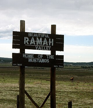
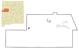
Ramah is a census-designated place (CDP) in McKinley County, New Mexico. The population was 461 as of the 2020 United States census.

<span class="mw-page-title-main">Thoreau, New Mexico</span> CDP in New Mexico, United States

Thoreau is a census-designated place (CDP) in McKinley County, New Mexico, United States. The population was 1,863 at the 2000 census. It is majority Native American, primarily of the Navajo Nation, as this community is located within its boundaries.

<span class="mw-page-title-main">Tohatchi, New Mexico</span> CDP in New Mexico, United States

Tohatchi is a census-designated place (CDP) in McKinley County, New Mexico, United States. It is known as a health-services and education hub along Highway 491. Its population was reported to be 785 at the 2020 census. As Tohatchi is located on the Navajo Nation, it is designated federal trust land.

<span class="mw-page-title-main">Tse Bonito, New Mexico</span> CDP in New Mexico, United States

Tse Bonito is a census-designated place (CDP) in McKinley County, New Mexico, United States and is part of the greater Window Rock, Arizona population center, and seat of the Navajo Nation government. The population was 261 at the 2000 census.

<span class="mw-page-title-main">Twin Lakes, New Mexico</span> CDP in New Mexico, United States

Twin Lakes is a census-designated place (CDP) in McKinley County, New Mexico, United States. The population was 1,069 at the 2000 census.

<span class="mw-page-title-main">Yah-ta-hey, New Mexico</span> CDP in New Mexico, United States

Yah-ta-hey is a census-designated place (CDP) in McKinley County, New Mexico, United States. As of the 2000 census, the CDP population was 580. The English name for this place is an approximation of a Navajo greeting, though the actual Navajo name means "like a devil", in reference to J.B. Tanner, who operated the trading post located here; the same name is used for Aneth, Utah, where Tanner also worked.

<span class="mw-page-title-main">Zuni Pueblo, New Mexico</span> Census-designated place in New Mexico, United States

Zuni Pueblo is a census-designated place (CDP) in McKinley County, New Mexico, United States. The population was 6,302 as of the 2010 Census. It is inhabited largely by members of the Zuni people.

<span class="mw-page-title-main">Cuba, New Mexico</span> Village in Sandoval County, New Mexico, United States

Cuba is a village in Sandoval County, New Mexico, United States. As of the 2010 census, the village population was 735. It is part of the Albuquerque Metropolitan Statistical Area.

<span class="mw-page-title-main">Torreon, Sandoval County, New Mexico</span> Census-designate place in Sandoval County, New Mexico, United States

Torreon is a census-designated place (CDP) in Sandoval County, New Mexico, United States. The population was 297 at the 2000 census. It is part of the Albuquerque Metropolitan Statistical Area.

<span class="mw-page-title-main">Crystal, New Mexico</span> Census-designated place in New Mexico, US

Crystal is a census-designated place (CDP) on the Navajo Nation in McKinley and San Juan counties in New Mexico, United States. The population was 311 at the 2010 census. It is located at the western end of the Narbona Pass.

Gallup-McKinley County Schools (GMCS) is a school district based in Gallup, New Mexico which serves students from Gallup and surrounding areas of McKinley County.

References

  1. "McKinley County, New Mexico". United States Census Bureau . Retrieved July 3, 2023.
  2. "Find a County". National Association of Counties. Archived from the original on May 31, 2011. Retrieved June 7, 2011.
  3. "New Mexico: Consolidated Chronology of State and County Boundaries". New Mexico Atlas of Historical County Boundaries. The Newberry Library. 2007. Archived from the original on August 22, 2016. Retrieved January 2, 2015.
  4. "2010 Census Gazetteer Files". United States Census Bureau. August 22, 2012. Archived from the original on January 1, 2015. Retrieved January 2, 2015.
  5. "U.S. Decennial Census". United States Census Bureau. Retrieved January 2, 2015.
  6. "Historical Census Browser". University of Virginia Library. Retrieved January 2, 2015.
  7. "Population of Counties by Decennial Census: 1900 to 1990". United States Census Bureau. Retrieved January 2, 2015.
  8. "Census 2000 PHC-T-4. Ranking Tables for Counties: 1990 and 2000" (PDF). United States Census Bureau. Archived (PDF) from the original on March 27, 2010. Retrieved January 2, 2015.
  9. "State & County QuickFacts". United States Census Bureau. Archived from the original on June 6, 2011. Retrieved September 30, 2013.
  10. "U.S. Census website". United States Census Bureau . Retrieved January 31, 2008.
  11. 1 2 3 "DP-1 Profile of General Population and Housing Characteristics: 2010 Demographic Profile Data". United States Census Bureau. Archived from the original on February 13, 2020. Retrieved January 24, 2016.
  12. "Population, Housing Units, Area, and Density: 2010 - County". United States Census Bureau. Archived from the original on February 13, 2020. Retrieved January 24, 2016.
  13. "DP03 SELECTED ECONOMIC CHARACTERISTICS – 2006-2010 American Community Survey 5-Year Estimates". United States Census Bureau. Archived from the original on February 13, 2020. Retrieved January 24, 2016.
  14. "Gallup-McKinley County Schools - High Schools". Gallup-McKinley County Schools. Retrieved May 28, 2021.
  15. "2020 CENSUS - SCHOOL DISTRICT REFERENCE MAP: McKinley County, NM" (PDF). U.S. Census Bureau. Archived (PDF) from the original on July 20, 2021. Retrieved July 20, 2021.
  16. "Home". Wingate Elementary School. Retrieved July 11, 2021.
  17. "Pueblo Pintado Community School". Bureau of Indian Education . Retrieved January 11, 2022.
  18. "U.S. Department of the Interior - Bureau of Indian Education". BIE Schools Directory | Bureau of Indian Education. Retrieved December 31, 2020.
  19. "Ch'ooshgai Community School". Bureau of Indian Education . Retrieved January 12, 2022.
  20. Leip, David. "Dave Leip's Atlas of U.S. Presidential Elections". uselectionatlas.org. Retrieved April 1, 2018.

35°35′N108°16′W / 35.58°N 108.26°W / 35.58; -108.26