Gray County | |
---|---|
Coordinates: 35°25′N100°49′W / 35.41°N 100.81°W | |
Country | United States |
State | Texas |
Founded | 1902 |
Named for | Peter W. Gray |
Seat | Pampa |
Largest city | Pampa |
Area | |
• Total | 929 sq mi (2,410 km2) |
• Land | 926 sq mi (2,400 km2) |
• Water | 3.4 sq mi (9 km2) 0.4% |
Population (2020) | |
• Total | 21,227 |
• Density | 23/sq mi (8.8/km2) |
Time zone | UTC−6 (Central) |
• Summer (DST) | UTC−5 (CDT) |
Congressional district | 13th |
Website | www |
Gray County is a county located in the U.S. state of Texas. As of the 2020 census, its population was 21,227. [1] The county seat is Pampa. [2] The county was created in 1876 and later organized in 1902. [3] is named for Peter W. Gray, [4] a Confederate lawyer and soldier in the American Civil War.
Gray County comprises the Pampa, TX micropolitan statistical area.
According to the U.S. Census Bureau, the county has a total area of 929 square miles (2,410 km2), of which 926 sq mi (2,400 km2) are land and 3.4 sq mi (8.8 km2) (0.4%) are covered by water. [5]
Census | Pop. | Note | %± |
---|---|---|---|
1880 | 56 | — | |
1890 | 203 | 262.5% | |
1900 | 480 | 136.5% | |
1910 | 3,405 | 609.4% | |
1920 | 4,663 | 36.9% | |
1930 | 22,090 | 373.7% | |
1940 | 23,911 | 8.2% | |
1950 | 24,728 | 3.4% | |
1960 | 31,535 | 27.5% | |
1970 | 26,949 | −14.5% | |
1980 | 26,386 | −2.1% | |
1990 | 23,967 | −9.2% | |
2000 | 22,744 | −5.1% | |
2010 | 22,535 | −0.9% | |
2020 | 21,227 | −5.8% | |
U.S. Decennial Census [6] 1850–2010 [7] 2010 [8] 2020 [9] |
Race / Ethnicity | Pop 2010 [8] | Pop 2020 [9] | % 2010 | % 2020 |
---|---|---|---|---|
White alone (NH) | 15,564 | 13,025 | 69.07% | 61.36% |
Black or African American alone (NH) | 1,055 | 835 | 4.68% | 3.93% |
Native American or Alaska Native alone (NH) | 152 | 141 | 0.67% | 0.66% |
Asian alone (NH) | 83 | 127 | 0.37% | 0.60% |
Pacific Islander alone (NH) | 1 | 0 | 0.00% | 0.00% |
Some Other Race alone (NH) | 11 | 37 | 0.05% | 0.17% |
Mixed Race/Multi-Racial (NH) | 304 | 715 | 1.35% | 3.37% |
Hispanic or Latino (any race) | 5,365 | 6,347 | 23.81% | 29.90% |
Total | 22,535 | 21,227 | 100.00% | 100.00% |
Note: the US Census treats Hispanic/Latino as an ethnic category. This table excludes Latinos from the racial categories and assigns them to a separate category. Hispanics/Latinos can be of any race.
As of the census [10] of 2000, 22,744 people, 8,793 households, and 6,049 families were residing in the county. The population density was 24 people per square mile (9.3 people/km2). The 10,567 housing units averaged 11 units per square mile (4.2/km2). The racial makeup of the county was 82.15% White, 5.85% African American, 0.94% Native American, 0.39% Asian, 8.25% from other races, and 2.42% from two or more races. About 13.01% of the population was Hispanic or Latino of any race.
Of the 8,793 households, 30.00% had children under the age of 18 living with them, 57.00% were married couples living together, 9.00% had a female householder with no husband present, and 31.20% were not families. About 28.70% of all households were made up of individuals, and 15.30% had someone living alone who was 65 years of age or older. The average household size was 2.39, and the average family size was 2.93.
In the county, the age distribution was 24.00% under 18, 8.40% from 18 to 24, 27.20% from 25 to 44, 22.30% from 45 to 64, and 18.10% who were 65 or older. The median age was 39 years. For every 100 females, there were 104.00 males. For every 100 females age 18 and over, there were 103.70 males.
The median income for a household in the county was $31,368, and for a family was $40,019. Males had a median income of $32,401 versus $20,158 for females. The per capita income for the county was $16,702. About 11.20% of families and 13.80% of the population were below the poverty line, including 17.60% of those under age 18 and 9.60% of those age 65 or over.
Prior to 1952, Gray County was primarily Democratic similar to most of Texas and the Solid South. The county only gave a Republican presidential candidate a majority before 1952 in 1928, when Herbert Hoover won the county due to anti-Catholic sentiment towards Al Smith. Starting with the 1952 election, the county has become a Republican stronghold along with the rest of the Texas Panhandle. This level of Republican dominance has increased in recent years, as every Republican presidential candidate in the second millennium has racked up 80% of the county's vote. Additionally, after the 2008 election, Democrats Barack Obama, Hillary Clinton, and Joe Biden have failed to win even 1,000 votes total in the county.
Year | Republican | Democratic | Third party | |||
---|---|---|---|---|---|---|
No. | % | No. | % | No. | % | |
2020 | 6,840 | 87.90% | 829 | 10.65% | 113 | 1.45% |
2016 | 6,500 | 87.78% | 701 | 9.47% | 204 | 2.75% |
2012 | 6,443 | 87.20% | 886 | 11.99% | 60 | 0.81% |
2008 | 6,924 | 85.13% | 1,153 | 14.18% | 56 | 0.69% |
2004 | 7,260 | 84.69% | 1,289 | 15.04% | 23 | 0.27% |
2000 | 6,732 | 82.25% | 1,376 | 16.81% | 77 | 0.94% |
1996 | 6,102 | 69.15% | 2,114 | 23.96% | 608 | 6.89% |
1992 | 6,105 | 58.86% | 2,426 | 23.39% | 1,841 | 17.75% |
1988 | 7,259 | 74.22% | 2,460 | 25.15% | 62 | 0.63% |
1984 | 8,955 | 81.50% | 2,003 | 18.23% | 30 | 0.27% |
1980 | 7,187 | 70.81% | 2,786 | 27.45% | 176 | 1.73% |
1976 | 6,010 | 60.33% | 3,872 | 38.87% | 80 | 0.80% |
1972 | 7,968 | 84.37% | 1,367 | 14.47% | 109 | 1.15% |
1968 | 5,994 | 55.53% | 2,374 | 21.99% | 2,427 | 22.48% |
1964 | 5,011 | 57.93% | 3,633 | 42.00% | 6 | 0.07% |
1960 | 6,197 | 68.76% | 2,802 | 31.09% | 14 | 0.16% |
1956 | 5,047 | 61.90% | 3,034 | 37.21% | 72 | 0.88% |
1952 | 5,467 | 61.73% | 3,367 | 38.02% | 23 | 0.26% |
1948 | 1,594 | 27.98% | 3,699 | 64.94% | 403 | 7.08% |
1944 | 1,739 | 34.86% | 3,067 | 61.48% | 183 | 3.67% |
1940 | 1,217 | 21.97% | 4,315 | 77.89% | 8 | 0.14% |
1936 | 464 | 9.59% | 4,347 | 89.83% | 28 | 0.58% |
1932 | 505 | 12.70% | 3,446 | 86.69% | 24 | 0.60% |
1928 | 1,871 | 65.35% | 986 | 34.44% | 6 | 0.21% |
1924 | 581 | 48.86% | 608 | 51.14% | 0 | 0.00% |
1920 | 251 | 30.95% | 529 | 65.23% | 31 | 3.82% |
1916 | 69 | 11.73% | 482 | 81.97% | 37 | 6.29% |
1912 | 13 | 3.09% | 272 | 64.61% | 136 | 32.30% |
Wheeler County is a county located in the U.S. state of Texas. As of the 2020 census, its population was 4,990. Its county seat is Wheeler. The county was formed in 1876 and organized in 1879. It is named for Royall Tyler Wheeler, a chief justice of the Texas Supreme Court.
Swisher County is a county in the U.S. state of Texas. As of the 2020 census, its population was 6,971. Its county seat is Tulia. The county was created in 1876 and later organized in 1890. It is named for James G. Swisher, a soldier of the Texas Revolution and signer of the Texas Declaration of Independence.
Stonewall County is a county located in the U.S. state of Texas. As of the 2020 census, its population was 1,245. Its county seat is Aspermont. The county was created in 1876 and organized in 1888. It is named for Stonewall Jackson, a general of the Confederate States Army.
Sherman County is a county located in the U.S. state of Texas. As of the 2020 census, its population was 2,782. Its county seat is Stratford. The county was created in 1876 and organized in 1889. It is named for Sidney Sherman, who fought in the Texas Revolution. Though both Sherman County and Sherman, Texas, are named for the same person, the city of Sherman is located in Grayson County, about 430 miles to the southeast.
Nacogdoches County is a county located in the U.S. state of Texas. As of the 2020 census, its population was 64,653. Its county seat is Nacogdoches.
Live Oak County is a county in the U.S. state of Texas. It was named for its native groves of live oak. George West is its county seat. Its population was 11,335 in the 2020 census.
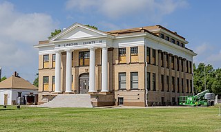
Lipscomb County is a county located in the U.S. state of Texas. As of the 2020 census, its population was 3,059. Its county seat is Lipscomb. The county was created in 1876 and organized in 1887. It is named for Judge Abner Smith Lipscomb, a secretary of state of the Republic of Texas.
Hemphill County is a county located in the U.S. state of Texas. As of the 2020 census, its population was 3,382. The county seat and only incorporated community in the county is the city of Canadian. The county was created in 1876 and organized in 1887. It is named for John Hemphill, a judge and Confederate congressman. Hemphill County is the most recent Texas county to permit alcohol sales.
Hall County is a county located in the U.S. state of Texas. As of the 2020 census, the population is 2,825. Its county seat is Memphis. The county was created in 1876 and later organized in 1890. It is named for Warren D. C. Hall, a secretary of war for the Republic of Texas.
Glasscock County is a county located in the U.S. state of Texas. As of the 2020 census, its population was 1,169. Its county seat is Garden City. The county was created in 1827 and later organized in 1869. It is named for George Washington Glasscock, an early settler of the Austin, Texas area and the namesake of Georgetown, Texas.
Donley County is a county located in the U.S. state of Texas. As of the 2020 census, its population was 3,258. Its county seat is Clarendon. The county was created in 1876 and later organized in 1882.
Dallam County is the north-westernmost county in the U.S. state of Texas. As of the 2020 Census, its population was 7,115. Its county seat is Dalhart. The county was founded in 1876 and later organized in 1891. It is named for James Wilmer Dallam, a lawyer and newspaper publisher.
Cooke County is a county in the U.S. state of Texas. At the 2020 census, its population was 41,668. The county seat is Gainesville. The county was founded in 1848 and organized the next year. It is named for William Gordon Cooke, a soldier during the Texas Revolution. It is a part of the Texoma region.
Collingsworth County is a county in the U.S. state of Texas. As of the 2020 census, its population was 2,652. Its county seat is Wellington. The county was created in 1876 and later organized in 1890. It is named for James Collinsworth, a signer of the Texas Declaration of Independence and first chief justice of the Republic of Texas. Collingsworth County was one of 30 prohibition, or entirely dry, counties in Texas, but a vote in 2017 changed this law.
Childress County is a county located in the U.S. state of Texas. As of the 2020 census, its population was 6,664. The county seat is Childress. The county was created in 1876 and later organized in 1887. It is named for George Campbell Childress, the author of the Texas Declaration of Independence.
Callahan County is a county located in the U.S. state of Texas. As of the 2020 census, the population was 13,708. Its county seat is Baird. The county was founded in 1858 and later organized in 1877. It is named for James Hughes Callahan, an American soldier in the Texas Revolution. Callahan County is included in the Abilene, Texas metropolitan statistical area.
Panhandle is the county seat of Carson County, Texas, United States. The population of the town was 2,452 at the 2010 census. Panhandle is part of the Amarillo metropolitan statistical area.
McLean is a town in Gray County, Texas, United States. It is part of the Pampa micropolitan statistical area. Its population was 778 as of the 2010 census.
Pampa is a city in Gray County, Texas, United States. Its population was 16,867 as of the 2020 census. Pampa is the county seat of Gray County and is the principal city of the Pampa micropolitan statistical area, which includes both Gray and Roberts Counties. Pampa is named after the Pampas Lowlands in Argentina, Uruguay, and southern Brazil.
Moore County is a county located in the U.S. state of Texas. As of the 2020 census, its population was 21,358. The county seat is Dumas. The county was created in 1876 and organized in 1892. It is named for Edwin Ward Moore, the commander of the Texas Navy. The Dumas micropolitan statistical area includes all of Moore County.