Marion County, Texas

Last updated

Marion County
MarionCountyCourthouse1 (1 of 1).jpg
Marion County Courthouse in Jefferson
Map of Texas highlighting Marion County.svg
Location within the U.S. state of Texas
Texas in United States.svg
Texas's location within the U.S.
Coordinates: 32°48′N94°22′W / 32.8°N 94.36°W / 32.8; -94.36
CountryFlag of the United States.svg United States
StateFlag of Texas.svg  Texas
Founded1860
Named for Francis Marion
Seat Jefferson
Largest cityJefferson
Area
  Total420 sq mi (1,100 km2)
  Land381 sq mi (990 km2)
  Water39 sq mi (100 km2)  9.4%
Population
 (2020)
  Total9,725
  Density23/sq mi (8.9/km2)
Time zone UTC−6 (Central)
  Summer (DST) UTC−5 (CDT)
Congressional district 1st
Website www.co.marion.tx.us

Marion County is a county located in the U.S. state of Texas. As of the 2020 census, its population was 9,725. [1] Its county seat is Jefferson. [2] Marion County is in East Texas and is named for Francis Marion, the Revolutionary War general from South Carolina who was nicknamed the "Swamp Fox".

Contents

History

Native Americans

The indigenous farming Caddoan Mississippian culture has been dated to 200 BCE in the area. The Hernando de Soto expedition of 1541 resulted in violent encounters with Native Americans. Spanish and French missionaries carried endemic diseases: resulting in epidemics of smallpox, measles malaria, and influenza among the Caddo. Eventually, the Caddo were forced to reservations. [3] [4] Shashidahnee (Timber Hill) is the last known permanent Marion County settlement of the Caddo people. During the 19th century, Shawnee, Delaware, and Kickapoo migrated to the area and settled here. [5]

County established

The legislature formed Marion County from Cass County in 1860 and named it for Revolutionary War Swamp Fox Francis Marion. [6] Jefferson, named after Thomas Jefferson became the county seat. [7]

The majority of the settlers had migrated from other southern states and brought enslaved African Americans with them as workers, or purchased them in slave markets. The county was developed as cotton plantations, and enslaved African Americans made up 51 percent of the population in 1860. In 1861, the white male voters in the county voted unanimously for secession from the Union. The county benefited financially from Confederate government contracts. [8]

In February 1869 the river steamboat Mittie Stephens caught fire from a torch basket that ignited a hay stack on board. Sixty-one people died, either from the fire or from being caught in the boat's paddlewheel as they jumped overboard. [9] [10]

Following the Civil War, the white minority used violence to impose dominance on the freedmen. On October 4, 1869, George Washington Smith, a delegate to the state Constitutional Convention, was murdered by a band of vigilantes while incarcerated in Jefferson. Smith's slaying resulted in the federal government assigning military troops to Jefferson. They offered some protection for the black majority during the Reconstruction era. [11]

During Reconstruction, Republican presidential races were supported by the black majority voters in the county. However, with the end of Reconstruction, white conservative Democrats regained control of the state legislature and, in 1898, passed various restrictions on voter registration and voting, including establishing White primaries. Because the Democratic Party dominated the state, its primaries afforded the only true competitive political races. Blacks were unable to vote in these primaries and were thus disenfranchised. Various forms of the white primary survived until 1944 when a US Supreme Court ruling overturned the practice as racially discriminatory and unconstitutional. [12] [13]

The Marion County brick courthouse was erected in 1914, designed by architect Elmer George Withers. [14] In the early 20th century, the Dick Taylor Camp of Confederate veterans erected a monument to honor the county's dead in the American Civil War, placing it outside the courthouse. [15]

Caddo Lake State Park was first proposed in 1924. From 1933 to 1937, during the Great Depression, men were hired into the Civilian Conservation Corps and made improvements to the park. The former army barracks and mess hall were converted to log cabins and a recreation hall for park goers. [16]

Geography

According to the U.S. Census Bureau, the county has a total area of 420 square miles (1,100 km2), of which 381 square miles (990 km2) is land and 39 square miles (100 km2) (9.4%) is water. [17]

Major highways

Entering Marion County from Louisiana along State Highway 49 Entering Marion County, Texas, from Louisiana, along Texas State Highway 49.jpg
Entering Marion County from Louisiana along State Highway 49

The TTC-69 component (recommended preferred) of the once-planned Trans-Texas Corridor went through Marion County. [18]

Adjacent counties and parish

Communities

Demographics

Historical population
CensusPop.Note
1860 3,977
1870 8,562115.3%
1880 10,98328.3%
1890 10,862−1.1%
1900 10,754−1.0%
1910 10,472−2.6%
1920 10,8864.0%
1930 10,371−4.7%
1940 11,45710.5%
1950 10,172−11.2%
1960 8,049−20.9%
1970 8,5175.8%
1980 10,36021.6%
1990 9,984−3.6%
2000 10,9419.6%
2010 10,546−3.6%
2020 9,725−7.8%
U.S. Decennial Census [19]
1850–2010 [20] 2010–2020 [21]
Demographic Profile of Marion County, Texas
(NH = Non-Hispanic)
Race / EthnicityPop 2010 [22] Pop 2020 [21] % 2010% 2020
White alone (NH)7,5646,86971.72%70.63%
Black or African American alone (NH)2,3191,84621.99%18.98%
Native American or Alaska Native alone (NH)72690.68%0.71%
Asian alone (NH)50480.47%0.49%
Pacific Islander alone (NH)300.03%0.00%
Some Other Race alone (NH)8450.08%0.46%
Mixed Race/Multi-Racial (NH)2024591.92%4.72%
Hispanic or Latino (any race)3283893.11%4.00%
Total10,5469,725100.00%100.00%

Note: the US Census treats Hispanic/Latino as an ethnic category. This table excludes Latinos from the racial categories and assigns them to a separate category. Hispanics/Latinos can be of any race.

According to the 2000 U.S. census, there were 10,941 people, 4,610 households, and 3,120 families residing in the county. [23] The population density was 29 people per square mile (11 people/km2). There were 6,384 housing units at an average density of 17 units per square mile (6.6/km2). The racial makeup of the county was 72.74% White, 23.91% Black or African American, 0.80% Native American, 0.22% Asian, 0.01% Pacific Islander, 0.79% from other races, and 1.54% from two or more races. 2.40% of the population were Hispanic or Latino of any race. The 2020 United States census reported a population of 9,725. [21] Its racial and ethnic makeup in 2020 was 70.63% non-Hispanic white, 18.98% Black or African American, 0.71% Native American, 0.49% Asian, 0.46% some other race, 4.72% multiracial, and 4.0% Hispanic or Latino of any race.

The median income for a household in the county was $25,347, and the median income for a family was $32,039. Males had a median income of $30,584 versus $17,885 for females. The per capita income for the county was $14,535. About 17.80% of families and 22.40% of the population were below the poverty line, including 29.90% of those under age 18 and 14.40% of those age 65 or over. According to the 2020 American Community Survey, the median household income was $39,093. [24]

Politics

United States presidential election results for Marion County, Texas [25]
Year Republican Democratic Third party
No.%No.%No.%
2020 3,47071.34%1,33927.53%551.13%
2016 2,98370.39%1,16527.49%902.12%
2012 2,73363.83%1,49534.91%541.26%
2008 2,56760.37%1,64438.66%410.96%
2004 2,44156.14%1,88443.33%230.53%
2000 2,03951.88%1,85247.12%390.99%
1996 1,26034.45%2,02855.46%36910.09%
1992 1,24529.03%2,15650.28%88720.69%
1988 1,85744.97%2,25554.61%170.41%
1984 2,33652.34%2,11147.30%160.36%
1980 1,66644.66%2,01554.02%491.31%
1976 1,29140.76%1,86058.73%160.51%
1972 1,68060.22%1,10639.64%40.14%
1968 63722.32%1,26044.15%95733.53%
1964 92740.25%1,37259.57%40.17%
1960 74243.88%90453.46%452.66%
1956 1,12660.93%70938.37%130.70%
1952 87747.43%97052.46%20.11%
1948 20018.48%70364.97%17916.54%
1944 21915.86%1,05776.54%1057.60%
1940 16711.76%1,25388.24%00.00%
1936 12912.31%91987.69%00.00%
1932 848.83%86190.54%60.63%
1928 44340.90%64059.10%00.00%
1924 34733.02%62058.99%847.99%
1920 39234.69%43038.05%30827.26%
1916 16627.04%44572.48%30.49%
1912 8518.48%33973.70%367.83%

See also

Related Research Articles

<span class="mw-page-title-main">Wharton County, Texas</span> County in Texas, United States

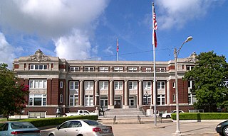
Wharton County is a county located in the U.S. state of Texas. As of the 2020 census, its population was 41,570. Its county seat is Wharton. The county was named for brothers William Harris Wharton and John Austin Wharton.

<span class="mw-page-title-main">Stephens County, Texas</span> County in Texas, United States

Stephens County is a county located in the U.S. state of Texas. As of the 2020 census, its population was 9,101. Its county seat is Breckenridge. The county was created in 1858 and organized in 1876. It was originally named Buchanan County, after U.S. President James Buchanan, but was renamed in 1861 for Alexander H. Stephens, the vice president of the Confederate States of America.

<span class="mw-page-title-main">San Saba County, Texas</span> County in Texas, United States

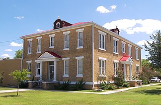
San Saba County is a county located on the Edwards Plateau in western Central Texas, United States. As of the 2020 census, its population was 5,730. Its county seat is San Saba. The county is named after the San Saba River, which flows through the county.

<span class="mw-page-title-main">Reagan County, Texas</span> County in Texas, United States

Reagan County is a county on the Edwards Plateau in the U.S. state of Texas. As of the 2020 census, its population was 3,385. The county seat is Big Lake. The county is named after John Henninger Reagan (1818–1905), who was the postmaster general of the Confederate States and also a U.S. senator, U.S. representative, and first chairman of the Railroad Commission of Texas.

<span class="mw-page-title-main">Rains County, Texas</span> County in Texas, United States

Rains County is a county located in the U.S. state of Texas. As of the 2020 census, its population was 12,164. Its seat is Emory. The county are named for Emory Rains, a Texas state legislator.

<span class="mw-page-title-main">Polk County, Texas</span> County in Texas, United States

Polk County is a county located in the U.S. state of Texas. As of the 2020 census, its population was 50,123. Its county seat is Livingston. The county is named after James K. Polk.

<span class="mw-page-title-main">Panola County, Texas</span> County in Texas, United States

Panola County is a county located in the U.S. state of Texas. As of the 2020 census, its population was 22,491. The county seat is Carthage. Located in East Texas and originally developed for cotton plantations, the county's name is derived from a Choctaw word for cotton.

<span class="mw-page-title-main">McMullen County, Texas</span> County in Texas, United States

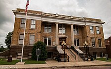
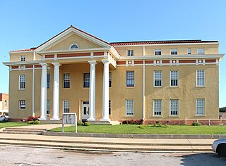
McMullen County is a county located in the U.S. state of Texas. As of the 2020 census, its population was 600, making it the fourth-least populous county in Texas. Its county seat is Tilden. The county was established from parts of Bexar County, Atascosa County, and Live Oak County in 1858 and later organized in 1877. It is named for John McMullen, founder of a colony in Texas. The McMullen County Courthouse was designed by the architect W.C. Stephenson, originally from Buffalo, New York. Stephenson also designed some 50 buildings in Beeville, including the Bee County Courthouse.

<span class="mw-page-title-main">McCulloch County, Texas</span> County in Texas, United States

McCulloch County is a county located on the Edwards Plateau in the U.S. state of Texas. At the 2020 census, its population was 7,630. Its county seat is Brady. The county was created in 1856 and later organized in 1876. It is named for Benjamin McCulloch, a famous Texas Ranger and Confederate general.

<span class="mw-page-title-main">Limestone County, Texas</span> County in the United States

Limestone County is a county in the U.S. state of Texas. As of the 2020 census, its population was 22,146. Its county seat is Groesbeck. The county was created in 1846.

<span class="mw-page-title-main">Jackson County, Texas</span> County in Texas, United States

Jackson County is a county in the U.S. state of Texas. As of the 2020 census its population was 14,988. Its county seat is Edna. The county was created in 1835 as a municipality in Mexico and in 1836 was organized as a county. It is named for Andrew Jackson, President of the United States from 1829 to 1837.

<span class="mw-page-title-main">Harrison County, Texas</span> County in Texas, United States

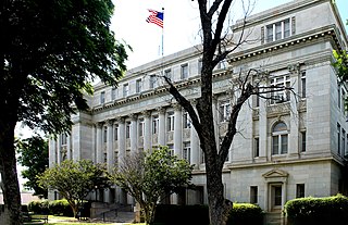
Harrison County is a county on the eastern border of the U.S. state of Texas. As of the 2020 United States census, its population was 68,839. The county seat is Marshall. The county was created in 1839 and organized in 1842. It is named for Jonas Harrison, a lawyer and Texas revolutionary.

<span class="mw-page-title-main">Garza County, Texas</span> County in Texas, United States

Garza County is a county located in the U.S. state of Texas. As of the 2020 census, its population was 5,816, of which most of the population were residing in its county seat, and only incorporated municipality, Post. The county was created in 1876 and later organized in 1907. Garza is named for a pioneer Bexar County family, as it was once a part of that county.

<span class="mw-page-title-main">Freestone County, Texas</span> County in Texas, United States

Freestone County is a county in the east-central part of the U.S. state of Texas. As of the 2020 census, its population was 19,435. Its county seat is Fairfield. The county was created in 1850 and organized the next year.

<span class="mw-page-title-main">Cherokee County, Texas</span> County in Texas, United States

Cherokee County is a county located in the U.S. state of Texas. As of the 2020 census, its population was 50,412. The county seat is Rusk, which lies 130 miles southeast of Dallas and 160 miles north of Houston. The county was named for the Cherokee, who lived in the area before being expelled in 1839. Cherokee County comprises the Jacksonville micropolitan statistical area, which is also included in the Tyler–Jacksonville combined statistical area.

<span class="mw-page-title-main">Cass County, Texas</span> County in Texas, United States

Cass County is a county located in the U.S. state of Texas. As of the 2020 census, its population was 28,454. The county seat is Linden. The county was named for United States Senator Lewis Cass (D-Michigan), who favored the U.S. annexation of Texas in the mid-19th century.

<span class="mw-page-title-main">Caldwell County, Texas</span> County in Texas, United States

Caldwell County is a county located in the U.S. state of Texas. As of the 2020 census, its population was 45,883. Its county seat is Lockhart. The county was founded in 1848 and named after Mathew Caldwell, a ranger captain who fought in the Battle of Plum Creek against the Comanches and against Santa Anna's armies during the Texas Revolution. Caldwell was also a signer of the Texas Declaration of Independence.

<span class="mw-page-title-main">Bowie County, Texas</span> County in Texas, United States

Bowie County is a county in the U.S. state of Texas. Its legal county seat is Boston, though its courthouse is located in New Boston. As of the 2020 census, the population was 92,893. Bowie County is part of the Texarkana metropolitan statistical area. The county is named for James Bowie, the legendary knife fighter who died at the Battle of the Alamo.

<span class="mw-page-title-main">Jefferson, Texas</span> City in Texas, United States

Jefferson is a city and county seat of Marion County, Texas, in Northeast Texas. It has population of 1,875 as of the 2020 United States census.

<span class="mw-page-title-main">Caddo Parish, Louisiana</span> Parish in Louisiana, United States

Caddo Parish is a parish located in the northwestern corner of the U.S. state of Louisiana. According to the 2020 U.S. census, the parish had a population of 237,848. The parish seat is Shreveport, which developed along the Red River.

References

  1. "Marion County, Texas". United States Census Bureau . Retrieved January 30, 2022.
  2. "Find a County". National Association of Counties. Retrieved June 7, 2011.
  3. "Caddo Timeline". Texas Beyond History. UT-Austin. Retrieved December 17, 2010.
  4. "Caddo History". Oklahoma Historical Society. Archived from the original on July 19, 2010. Retrieved December 17, 2010.
  5. Teague, Wells (2000). "Where We Came From". Calling Texas Home: A Lively Look at What It Means to Be a Texan. Wildcat Canyon Press. p. 15. ISBN   978-1-885171-38-2.
  6. The History of Marion County. Union Historical Company. 1881. pp. 248–249.
  7. "Jefferson, Texas". Texas Escapes. Texas Escapes - Blueprints For Travel, LLC. Retrieved December 17, 2010.
  8. Atkins, Mark Howard. "Marion County, Texas". Handbook of Texas Online. Texas State Historical Association. Retrieved December 17, 2010.
  9. Hodge, Larry D (2000). Official Guide to Texas Wildlife Management Areas. Texas Parks and Wildlife Press. p. 133. ISBN   978-1-885696-35-9.
  10. McDonald, PhD, Archie P. "The Mittie Stephens Disaster". Texas Escapes. Texas Escapes - Blueprints For Travel, LLC. Retrieved December 17, 2010.
  11. Lale, Max S. "Stockade Case". Handbook of Texas Online. Texas State Historical Association. Retrieved December 17, 2010.
  12. Greenberg, Sanford N. "White Primary". Handbook of Texas Online. Texas State Historical Association. Retrieved December 17, 2010.
  13. Williams, Patrick G. “Suffrage Restriction in Post-Reconstruction Texas: Urban Politics and the Specter of the Commune.” The Journal of Southern History, vol. 68, no. 1, 2002, pp. 31–64. JSTOR, www.jstor.org/stable/3069690. Accessed September 7, 2020.
  14. "Marion County Courthouse". Texas Escapes. Texas Escapes - Blueprints For Travel, LLC. Retrieved December 17, 2010.
  15. "Confederate Monument". Texas Confederate Veterans. Retrieved December 17, 2010.
  16. "Caddo Lake State Park". Texas Parks and Wildlife Department. Retrieved December 17, 2010.
  17. "2010 Census Gazetteer Files". United States Census Bureau. August 22, 2012. Retrieved May 4, 2015.
  18. TxDoT, TTC Section F, Detailed Maps 1 & 2, 2007-12-28 Archived February 7, 2009, at the Wayback Machine
  19. "Decennial Census of Population and Housing by Decades". US Census Bureau.
  20. "Texas Almanac: Population History of Counties from 1850–2010" (PDF). Texas Almanac. Archived (PDF) from the original on October 9, 2022. Retrieved May 4, 2015.
  21. 1 2 3 "P2 HISPANIC OR LATINO, AND NOT HISPANIC OR LATINO BY RACE - 2020: DEC Redistricting Data (PL 94-171) - Marion County, Texas". United States Census Bureau .
  22. "P2 HISPANIC OR LATINO, AND NOT HISPANIC OR LATINO BY RACE - 2010: DEC Redistricting Data (PL 94-171) - Marion County, Texas". United States Census Bureau .
  23. "U.S. Census website". United States Census Bureau . Retrieved May 14, 2011.
  24. "2020 ACS Financial Characteristics". data.census.gov. Retrieved May 13, 2022.
  25. Leip, David. "Dave Leip's Atlas of U.S. Presidential Elections". uselectionatlas.org. Retrieved July 26, 2018.

32°48′N94°22′W / 32.80°N 94.36°W / 32.80; -94.36