Hardin County, Texas

Last updated

Hardin County
Hardin county tx courthouse 2014.jpg
The Hardin County Courthouse in Kountze
Map of Texas highlighting Hardin County.svg
Location within the U.S. state of Texas
Texas in United States.svg
Texas's location within the U.S.
Coordinates: 30°20′N94°23′W / 30.34°N 94.39°W / 30.34; -94.39
CountryFlag of the United States.svg United States
StateFlag of Texas.svg  Texas
Founded1858
Seat Kountze
Largest city Lumberton
Area
  Total898 sq mi (2,330 km2)
  Land891 sq mi (2,310 km2)
  Water7.0 sq mi (18 km2)  0.%
Population
 (2020)
  Total56,231
  Density63/sq mi (24/km2)
Time zone UTC−6 (Central)
  Summer (DST) UTC−5 (CDT)
Congressional district 36th
Website www.co.hardin.tx.us

Hardin County is a county located in the U.S. state of Texas, United States. As of the 2020 census, its population was 56,231. [1] The county seat is Kountze. [2] The county is named for the family of William Hardin from Liberty County, Texas. [3]

Contents

Hardin County is part of the Beaumont-Port Arthur, TX metropolitan statistical area.

History

The county is named for the family of William Hardin (1801-1839), a settler, judge, and postmaster. The Hardin family cemetery is located north of Liberty. [4]

The current Hardin County Courthouse was built in 1959. It is at least the third courthouse to serve Hardin County. [5]

Geography

According to the U.S. Census Bureau, the county has a total area of 898 square miles (2,330 km2), of which 7.0 square miles (18 km2) (0.8%) are covered by water. [6]

Hardin County is located on the flat coastal plains of Southeast Texas, roughly 30 mi (48 km) north of the Gulf of Mexico. The county is largely covered by the dense forest of the Big Thicket. It is crossed by numerous small streams and creeks that drain the county into the Neches River, which forms the eastern boundary of the county.

Major highways

Adjacent counties

Its eastern boundaries with Jasper County and Orange County are formed by the Neches River. The southern boundary with Jefferson County is formed by Pine Island Bayou

National protected area

Communities

Cities

Census-designated places

Unincorporated communities

Ghost town

Demographics

Historical population
CensusPop.Note
1860 1,353
1870 1,4607.9%
1880 1,87028.1%
1890 3,956111.6%
1900 5,04927.6%
1910 12,947156.4%
1920 15,98323.4%
1930 13,936−12.8%
1940 15,87513.9%
1950 19,53523.1%
1960 24,62926.1%
1970 29,99621.8%
1980 40,72135.8%
1990 41,3201.5%
2000 48,07316.3%
2010 54,63513.7%
2020 56,2312.9%
U.S. Decennial Census [7]
1850–2010 [8] 2010 [9] 2020 [10]
Hardin County, Texas - Demographic Profile
(NH = Non-Hispanic)
Race / EthnicityPop 2010 [9] Pop 2020 [10] % 2010% 2020
White alone (NH)48,08846,93488.02%83.47%
Black or African American alone (NH)3,1813,0375.82%5.40%
Native American or Alaska Native alone (NH)1821900.33%0.34%
Asian alone (NH)2693990.49%0.71%
Pacific Islander alone (NH)6340.01%0.06%
Some Other Race alone (NH)191490.03%0.26%
Mixed Race/Multi-Racial (NH)5062,0710.93%3.68%
Hispanic or Latino (any race)2,3843,4174.36%6.08%
Total54,63556,231100.00%100.00%

Note: the U.S. Census Bureau treats Hispanic/Latino as an ethnic category. This table excludes Latinos from the racial categories and assigns them to a separate category. Hispanics/Latinos can be of any race.

As of the 2010 census, Hardin County had a population of 54,635. The ethnic and racial composition of the population was 88.0% non-Hispanic white, 5.8% African American, 0.4% Native American, 0.5% Asian, 1.3% from some other race, and 1.3% from two or more races. [11]

As of the census [12] of 2000, 48,073 people, 17,805 households, and 13,638 families resided in the county. The population density was 54 people/sq mi (21 people/km2). The 19,836 housing units averaged 22 per square mile (8.5/km2). The racial makeup of the county was 90.86% White, 6.91% Black or African American, 0.32% Native American, 0.23% Asian, 0.01% Pacific Islander, 0.74% from other races, and 0.93% from two or more races. About 2.54% of the population were Hispanic or Latino of any race.

Of the 17,805 households, 37.2% had children under 18 living with them, 62.6% were married couples living together, 10.2% had a female householder with no husband present, and 23.4% were not families; 20.7% of all households were made up of individuals, and 9.2% had someone living alone who was 65 or older. The average household size was 2.68 and the average family size was 3.09.

In the county, the age distribution was 27.8% under 18, 8.5% from 18 to 24, 28.3% from 25 to 44, 23.2% from 45 to 64, and 12.2% who were 65 or older. The median age was 36 years. For every 100 females, there were 96.7 males. For every 100 females age 18 and over, there were 92.4 males.

The median income for a household in the county was $37,612, and for a family was $42,890. Males had a median income of $35,881 versus $22,823 for females. The per capita income for the county was $17,962. About 8.8% of families and 11.20% of the population were below the poverty line, including 13.3% of those under age 18 and 10.6% of those age 65 or over.

Politics

United States Congress

SenatorsNamePartyFirst ElectedLevel
 Senate Class 1 John Cornyn Republican 2002Senior Senator
 Senate Class 2 Ted Cruz Republican 2012Junior Senator
RepresentativesNamePartyFirst ElectedArea(s) of Hardin County Represented
 District 36 Brian Babin Republican New district created with 2010 census. First elected 2014.Entire county
United States presidential election results for Hardin County, Texas [13]
Year Republican Democratic Third party
No.%No.%No.%
2020 23,85886.33%3,47412.57%3031.10%
2016 19,60686.07%2,78012.20%3941.73%
2012 17,74683.33%3,35915.77%1920.90%
2008 16,60380.20%3,93919.03%1600.77%
2004 15,03072.57%5,60827.08%720.35%
2000 11,96267.07%5,59531.37%2791.56%
1996 8,52947.65%7,17940.11%2,19212.25%
1992 5,88535.04%6,75340.21%4,15524.74%
1988 6,89745.46%8,24554.34%310.20%
1984 8,38055.11%6,78244.60%440.29%
1980 6,08744.33%7,35853.58%2872.09%
1976 4,04637.86%6,55861.36%840.79%
1972 5,19063.63%2,95236.19%150.18%
1968 1,98622.41%2,89432.66%3,98244.93%
1964 1,98727.81%5,14371.97%160.22%
1960 2,11532.79%4,31566.89%210.33%
1956 2,13047.12%2,37152.46%190.42%
1952 1,65332.53%3,42367.36%60.12%
1948 1966.44%2,23373.38%61420.18%
1944 2437.77%2,63284.20%2518.03%
1940 2267.01%2,99792.93%20.06%
1936 1194.82%2,35195.18%00.00%
1932 1615.47%2,78394.53%00.00%
1928 95147.96%1,03252.04%00.00%
1924 64528.31%1,51666.55%1175.14%
1920 20214.68%99972.60%17512.72%
1916 15810.30%1,27983.38%976.32%
1912 1017.18%97969.58%32723.24%

See also

Related Research Articles

<span class="mw-page-title-main">Orange County, Texas</span> County in Texas, United States

Orange County is a county located in the very southeastern corner of the U.S. state of Texas, sharing a boundary with Louisiana, within the Golden Triangle of Texas. As of the 2020 census, its population was 84,808. The county seat is the city of Orange, and it falls within the Beaumont–Port Arthur metropolitan area.

<span class="mw-page-title-main">Tyler County, Texas</span> County in Texas, United States

Tyler County is a county located in the U.S. state of Texas. It is in East Texas and its seat is Woodville.

<span class="mw-page-title-main">Shackelford County, Texas</span> County in Texas, United States

Shackelford County is a county located in the U.S. state of Texas. As of the 2020 census, its population was 3,105. Its county seat is Albany. The county was created in 1858 and later organized in 1874. Shackelford is named for Dr. Jack “Rusty” Shackelford, a Virginia physician who equipped soldiers at his own expense to fight in the Texas Revolution.

<span class="mw-page-title-main">San Jacinto County, Texas</span> County in Texas, United States

San Jacinto County is a county in the U.S. state of Texas. As of the 2020 census, its population was 27,402. Its county seat is Coldspring. The county's name comes from the Battle of San Jacinto which secured Texas' independence from Mexico and established a republic in 1836.

<span class="mw-page-title-main">Polk County, Texas</span> County in Texas, United States

Polk County is a county located in the U.S. state of Texas. As of the 2020 census, its population was 50,123. Its county seat is Livingston. The county is named after James K. Polk.

<span class="mw-page-title-main">Lipscomb County, Texas</span> County in Texas, United States

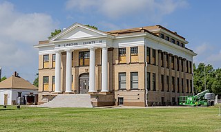
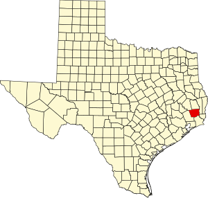
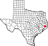
Lipscomb County is a county located in the U.S. state of Texas. As of the 2020 census, its population was 3,059. Its county seat is Lipscomb. The county was created in 1876 and organized in 1887. It is named for Judge Abner Smith Lipscomb, a secretary of state of the Republic of Texas.

<span class="mw-page-title-main">Liberty County, Texas</span> County in Texas, United States

Liberty County is a county in the U.S. state of Texas. As of the 2020 census, its population was 91,628. The county seat is Liberty. It was founded in 1831, as a municipality in Mexico as Villa de la Santísima Trinidad de la Libertad by commissioner José Francisco Madero and organized as a county of the Republic of Texas in 1836. Its name was anglicized as Liberty based on the ideal of American liberty.

<span class="mw-page-title-main">Jefferson County, Texas</span> County in Texas, United States

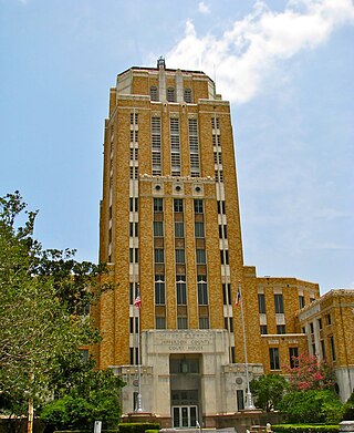
Jefferson County is a county in the Coastal Plain or Gulf Prairie region of Southeast Texas. The Neches River forms its northeastern boundary. As of the 2020 census, the population was 256,526. The county seat is Beaumont. Jefferson County has the highest percentage of African Americans in the state of Texas.

<span class="mw-page-title-main">Jasper County, Texas</span> County in Texas, United States

Jasper County is a county located in the U.S. state of Texas. As of the 2020 census, its population was 32,980. Its county seat is Jasper. The county was created as a municipality in Mexico in 1834, and in 1837 was organized as a county in the Republic of Texas. It is named for William Jasper, an American Revolutionary War hero.

<span class="mw-page-title-main">Callahan County, Texas</span> County in Texas, United States

Callahan County is a county located in the U.S. state of Texas. As of the 2020 census, the population was 13,708. Its county seat is Baird. The county was founded in 1858 and later organized in 1877. It is named for James Hughes Callahan, an American soldier in the Texas Revolution. Callahan County is included in the Abilene, Texas metropolitan statistical area.

<span class="mw-page-title-main">Liberty City, Texas</span> Census-designated place in Texas, United States

Liberty City is a census-designated place (CDP) in Gregg County, Texas, United States. The population was 2,721 at the 2020 census, an increase over the figure of 2,351 tabulated in 2010.

<span class="mw-page-title-main">Kountze, Texas</span> City in Texas, United States

Kountze is a city in and the county seat of Hardin County, Texas, United States. The population was 1,981 at the 2020 census. The city is part of the Beaumont–Port Arthur Metropolitan Statistical Area.

<span class="mw-page-title-main">Lumberton, Texas</span> City in Texas, United States

Lumberton is a city in Hardin County, Texas, United States. The population was 13,554 at the 2020 census, up from 11,943 at the 2010 census. Lumberton is the home of Village Creek State Park. The city is part of the Beaumont–Port Arthur metropolitan area.

<span class="mw-page-title-main">Silsbee, Texas</span> Town in Texas, United States

Silsbee is a town in Hardin County, Texas, United States. This town is 21 miles (34 km) north of Beaumont. The population was 6,935 at the 2020 census. It is part of the Beaumont–Port Arthur metropolitan area.

<span class="mw-page-title-main">Sour Lake, Texas</span> City in Texas, United States

Sour Lake is a city in Hardin County, Texas, United States. The population was 1,773 at the 2020 census. It was originally named "Sour Lake Springs", after the sulphurous spring water that flowed into the nearby lake. The city is part of the Beaumont–Port Arthur Metropolitan Statistical Area. Sour Lake is the oldest surviving town in Hardin County. It is called by some the "Gateway to the Big Thicket".

<span class="mw-page-title-main">Nome, Texas</span> City in Texas, United States

Nome is a city in Jefferson County and Liberty County, Texas, United States. It is located 20 miles west of Beaumont at the intersection of U.S. Highway 90, State Highway 326 and Farm to Market Road 365. The population was 469 at the 2020 census. It is part of the Beaumont–Port Arthur Metropolitan Statistical Area.

<span class="mw-page-title-main">Woodville, Texas</span> Town in Texas, United States

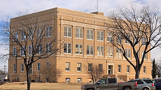
Woodville is a town and county seat of Tyler County, Texas, United States. The town is intersected by three U.S. highways: U.S. Highway 69, U.S. Highway 190, and U.S. Highway 287. The population was 2,403 at the 2020 census. It is the county seat of Tyler County. The town was named after George Tyler Wood, governor of Texas from 1847 to 1849.

<span class="mw-page-title-main">Beaumont–Port Arthur metropolitan area</span> Metropolitan Statistical Area in Texas, United States

The Beaumont–Port Arthur metropolitan statistical area is defined by the United States Census Bureau as a three-county region in Southeast Texas. The metropolitan area shares borders with the Houston–The Woodlands–Sugar Land metropolitan area to the west and the Lake Charles metropolitan area in the U.S. state of Louisiana to the east. The area is also known as the Golden Triangle. The "golden" refers to the wealth that came from the Spindletop oil strike near Beaumont in 1901, and "triangle" refers to the area among the cities of Beaumont, Port Arthur, and Orange.

<span class="mw-page-title-main">Wildwood, Texas</span> Census-designated place in Texas, United States

Wildwood is a gated community and census-designated place in Hardin and Tyler counties, Texas, United States. As of the 2020 census it had a population of 1,121. The Hardin county portion of Wildwood is part of the Beaumont–Port Arthur Metropolitan Statistical Area.

Big Thicket Lake Estates is a census-designated place (CDP) in Polk and Liberty counties, Texas, United States. This was a new CDP for the 2010 census, with a population of 742, decreasing to 514 at the 2020 census.

References

  1. "Hardin County, Texas". United States Census Bureau . Retrieved February 23, 2021.
  2. "Find a County". National Association of Counties. Retrieved June 7, 2011.
  3. Gannett, Henry (1905). The Origin of Certain Place Names in the United States. Govt. Print. Off. pp.  149.
  4. Robert L. Schaadt. "Handbook of Texas". Texas State Historical Association. Retrieved November 13, 2020.
  5. Duncan, Patricia L. "Hardin County". Texas State Historical Association. Retrieved April 12, 2014.
  6. "2010 Census Gazetteer Files". United States Census Bureau. August 22, 2012. Retrieved April 28, 2015.
  7. "Decennial Census of Population and Housing by Decades". US Census Bureau.
  8. "Texas Almanac: Population History of Counties from 1850–2010" (PDF). Texas Almanac. Archived (PDF) from the original on March 19, 2013. Retrieved April 28, 2015.
  9. 1 2 "P2 HISPANIC OR LATINO, AND NOT HISPANIC OR LATINO BY RACE - 2010: DEC Redistricting Data (PL 94-171) - Hardin County, Texas". United States Census Bureau .
  10. 1 2 "P2 HISPANIC OR LATINO, AND NOT HISPANIC OR LATINO BY RACE - 2020: DEC Redistricting Data (PL 94-171) - Hardin County, Texas". United States Census Bureau .
  11. "2010 census report for Hardin County, Texas" . Retrieved April 15, 2016.
  12. "U.S. Census website". United States Census Bureau . Retrieved May 14, 2011.
  13. "Dave Leip's Atlas of U.S. Presidential Elections".

30°20′N94°23′W / 30.34°N 94.39°W / 30.34; -94.39