
Mare Imbrium is a vast lava plain within the Imbrium Basin on the Moon and is one of the larger craters in the Solar System. The Imbrium Basin formed from the collision of a proto-planet during the Late Heavy Bombardment. Basaltic lava later flooded the giant crater to form the flat volcanic plain seen today. The basin's age has been estimated using uranium–lead dating methods to approximately 3.9 billion years ago, and the diameter of the impactor has been estimated to be 250 ± 25 km. The Moon's maria have fewer features than other areas of the Moon because molten lava pooled in the craters and formed a relatively smooth surface. Mare Imbrium is not as flat as it would have originally been when it first formed as a result of later events that have altered its surface.
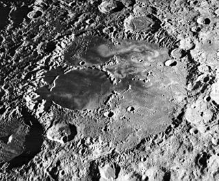
Mare Ingenii is one of the few lunar mare features on the far side of the Moon. The mare sits in the Ingenii basin, which is of the Pre-Nectarian epoch, which lies in turn in the outer part of the older and much larger South Pole–Aitken basin. The mare material located in Ingenii and the surrounding craters is of the Upper Imbrian epoch. The dark circular feature which dominates this mare is the crater Thomson, with the overflow from Ingenii/Thomson directly to the east. Mare Ingenii is incompletely and thinly covered over much of its expanse with mare lava sheets. The light grey crater to the south of Mare Ingenii is Obruchev.

Mare Cognitum is a lunar mare located in a basin or large crater which sits in the second ring of Oceanus Procellarum. To the northwest of the mare is the Montes Riphaeus mountain range, part of the rim of the buried crater or basin containing the mare. Previously unnamed, the mare received its name in 1964 in reference to its selection as the target for the successful impact probe Ranger 7, the first American spacecraft to return closeup images of the Moon's surface.
Mare Insularum is a lunar mare located in the Insularum basin just south of the western Mare Imbrium. The basin material is of the Lower Imbrian epoch, with the mare material of the Upper Imbrian epoch. The mare is bordered by the craters Copernicus on the east, and Kepler on the west. Oceanus Procellarum joins the mare to the southwest.

The Fra Mauro formation is a formation on the near side of Earth's Moon that served as the landing site for the American Apollo 14 mission in 1971. It is named after the 80-kilometer-diameter crater Fra Mauro, located within it. The formation, as well as Fra Mauro crater, take their names from a 15th-century Italian monk and mapmaker of the same name. Apollo 13 was originally scheduled to land in the Fra Mauro highlands, but was unable due to an in-flight technical failure.

The lunar geological timescale divides the history of Earth's Moon into five generally recognized periods: the Copernican, Eratosthenian, Imbrian, Nectarian, and Pre-Nectarian. The boundaries of this time scale are related to large impact events that have modified the lunar surface, changes in crater formation through time, and the size-frequency distribution of craters superposed on geological units. The absolute ages for these periods have been constrained by radiometric dating of samples obtained from the lunar surface. However, there is still much debate concerning the ages of certain key events, because correlating lunar regolith samples with geological units on the Moon is difficult, and most lunar radiometric ages have been highly affected by an intense history of bombardment.

Alphonsus is an ancient impact crater on the Moon that dates from the pre-Nectarian era. It is located on the lunar highlands on the eastern end of Mare Nubium, west of the Imbrian Highlands, and slightly overlaps the crater Ptolemaeus to the north. To the southwest is the smaller Alpetragius. The crater name was approved by the IAU in 1935.

Fra Mauro is the worn remnant of a walled lunar plain. It is part of the surrounding Fra Mauro formation, being located to the northeast of Mare Cognitum and southeast of Mare Insularum. Attached to the southern rim are the co-joined craters Bonpland and Parry, which intrude into the formation forming inward-bulging walls. The crater is named after Italian geographer Fra Mauro.

Cayley is a small lunar impact crater that is located in a lava-flooded region to the west of Mare Tranquillitatis. It was named after the 19th-century English mathematician Arthur Cayley. It lies to the northwest of the smaller crater De Morgan and the larger D'Arrest. West and slightly north of Cayley is Whewell, a crater of about the same dimensions. To the north is a linear rille designated Rima Ariadaeus, which follows a course to the east-southeast.

The geology of the Moon is quite different from that of Earth. The Moon lacks a true atmosphere, and the absence of free oxygen and water eliminates erosion due to weather. Instead, the surface is eroded much more slowly through the bombardment of the lunar surface by micrometeorites. It does not have any known form of plate tectonics, it has a lower gravity, and because of its small size, it cooled faster. In addition to impacts, the geomorphology of the lunar surface has been shaped by volcanism, which is now thought to have ended less than 50 million years ago. The Moon is a differentiated body, with a crust, mantle, and core.
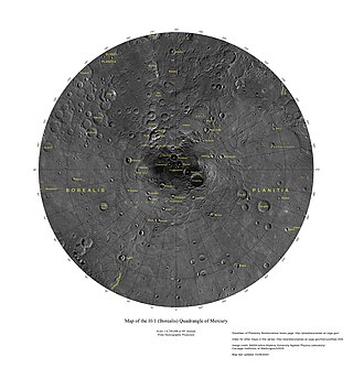
The Borealis quadrangle is a quadrangle on Mercury surrounding the north pole down to 65° latitude. It was mapped in its entirety by the MESSENGER spacecraft, which orbited the planet from 2008 to 2015, excluding areas of permanent shadow near the north pole. Only approximately 25% of the quadrangle was imaged by the Mariner 10 spacecraft during its flybys in 1974 and 1975. The quadrangle is now called H-1.

The Tolstoj quadrangle in the equatorial region of Mercury runs from 144 to 216° longitude and -25 to 25° latitude. It was provisionally called "Tir", but renamed after Leo Tolstoy by the International Astronomical Union in 1976. Also called Phaethontias.

The Shakespeare quadrangle is a region of Mercury running from 90 to 180° longitude and 20 to 70° latitude. It is also called Caduceata.
The Caloris group is a set of geologic units on Mercury. McCauley and others have proposed the name “Caloris Group” to include the mappable units created by the impact that formed the Caloris Basin and have formally named four formations within the group, which were first recognized and named informally by Trask and Guest based on imagery from the Mariner 10 spacecraft that flew by Mercury in 1974 and 1975. The extent of the formations within the group have been expanded and refined based on imagery and other data from the MESSENGER spacecraft which orbited Mercury from 2011 to 2015, and imaged parts of the planet that were in shadow at the time of the Mariner 10 encounters.

The Kuiper quadrangle, located in a heavily cratered region of Mercury, includes the young, 55-km-diameter crater Kuiper, which has the highest albedo recorded on the planet, and the small crater Hun Kal, which is the principal reference point for Mercurian longitude. Impact craters and basins, their numerous secondary craters, and heavily to lightly cratered plains are the characteristic landforms of the region. At least six multiringed basins ranging from 150 km to 440 km in diameter are present. Inasmuch as multiringed basins occur widely on that part of Mercury photographed by Mariner 10, as well as on the Moon and Mars, they offer a potentially valuable basis for comparison between these planetary bodies.

The Beethoven quadrangle is located in the equatorial region of Mercury, in the center of the area imaged by Mariner 10. Most pictures of the quadrangle were obtained at high sun angles as the Mariner 10 spacecraft receded from the planet. Geologic map units are described and classified on the basis of morphology, texture, and albedo, and they are assigned relative ages based on stratigraphic relations and on visual comparisons of the density of superposed craters. Crater ages are established by relative freshness of appearance, as indicated by topographic sharpness of their rim crests and degree of preservation of interior and exterior features such as crater floors, walls, and ejecta aprons. Generally, topography appears highly subdued because of the sun angle, and boundaries between map units are not clearly defined.

The Michelangelo quadrangle is in the southern hemisphere of the planet Mercury, where the imaged part is heavily cratered terrain that has been strongly influenced by the presence of multiring basins. At least four such basins, now nearly obliterated, have largely controlled the distribution of plains materials and structural trends in the map area. Many craters, interpreted to be of impact origin, display a spectrum of modification styles and degradation states. The interaction between basins, craters, and plains in this quadrangle provides important clues to geologic processes that have formed the morphology of the mercurian surface.
The Descartes Highlands is an area of lunar highlands located on the near side that served as the landing site of the American Apollo 16 mission in early 1972. The Descartes Highlands is located in the area surrounding Descartes crater, after which the feature received its name.

Hadley–Apennine is a region on the near side of Earth's Moon that served as the landing site for the American Apollo 15 mission, the fourth crewed landing on the Moon and the first of the "J-missions", in July 1971. The site is located on the eastern edge of Mare Imbrium on a lava plain known as Palus Putredinis. Hadley–Apennine is bordered by the Montes Apenninus, a mountain range, and Hadley Rille, a meandering channel, on the east and west, respectively.

Volcanism on the Moon is represented by the presence of volcanoes, pyroclastic deposits and vast lava plains on the lunar surface. The volcanoes are typically in the form of small domes and cones that form large volcanic complexes and isolated edifices. Calderas, large-scale collapse features generally formed late in a volcanic eruptive episode, are exceptionally rare on the Moon. Lunar pyroclastic deposits are the result of lava fountain eruptions from volatile-laden basaltic magmas rapidly ascending from deep mantle sources and erupting as a spray of magma, forming tiny glass beads. However, pyroclastic deposits formed by less common non-basaltic explosive eruptions are also thought to exist on the Moon. Lunar lava plains cover large swaths of the Moon's surface and consist mainly of voluminous basaltic flows. They contain a number of volcanic features related to the cooling of lava, including lava tubes, rilles and wrinkle ridges.
 The Descartes highlands region, with the Apollo 16 landing point near center. Furrows and approximate outline of the two units of the Descartes highlands are indicated. Plains of the Cayley Formation are shaded; craters are shown by hachures. Northwest-southeast trend of the furrows on the western side of the map area is radial to the Imbrium Basin.
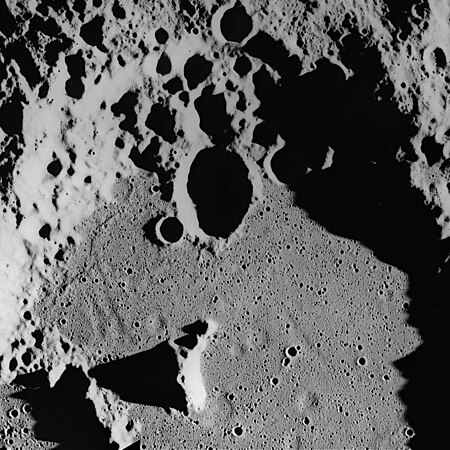 Ghost craters on the surface of the Cayley Formation in the bottom of Albategnius crater. Albategnius B crater (above center) is approximately 15 km across. Subdued troughs trending north-northwest may be buried Imbrium sculpture. The Cayley Formation may be mantling fresh craters to produce a subdued flatbottomed bowl shape.
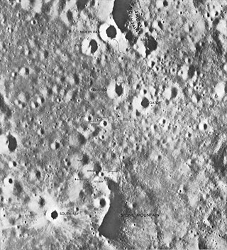
 View of the lunar surface representing the Cayley Formation around the Lunar Module Orion, taken from Station 4 on Stone Mountain south of the landing point.

