North Ray (crater)

Last updated
North Ray
North Ray crater AS16-P-4618 ASU.jpg
Apollo 16 image
Coordinates 8°49′S15°29′E / 8.82°S 15.48°E / -8.82; 15.48
Diameter 950 m [1]
Depth 240 m
Eponym Astronaut-named feature
LRO image North Ray crater M1136456506RC.jpg
LRO image

North Ray crater is a small crater in the Descartes Highlands of the Moon visited by the astronauts of Apollo 16. The name of the crater was formally adopted by the IAU in 1973. [1] It is the largest crater sampled by astronauts during the Apollo program.

Contents

The Apollo 16 Lunar Module (LM) Orion landed between North Ray and South Ray craters on April 21, 1972. The astronauts John Young and Charles Duke explored the area between the craters over the course of three EVAs using a Lunar Roving Vehicle, or rover. They visited North Ray on EVA 3, at station 11, about 4.4 km north of the landing site. On the way, they drove along the rim of the similar sized but older crater Palmetto, which is approximately 3 km south of North Ray.

North Ray crater is approximately 1 km in diameter and approximately 240 m deep. [2] The astronauts observed that the upper 50 m of the slope is gentle, but that it becomes steep below 50 m, and they could not observe the bottom. The inner slopes are covered by boulders up to 5 m across. A huge (10 m high x 20 m long) boulder, known as House Rock, lies near the southeastern rim. A smaller boulder that is almost certainly a fragment of House Rock is officially known as South Boulder, but unofficially known as Outhouse Rock. [3] The ray system, which can be seen from orbit, was not obvious on the ground.

North Ray cuts into the Cayley Formation of Imbrian age, [4] but the crater itself is much younger, of Copernican age, based on the presence of rays. (See also section on age below.)

Panorama of North Ray Crater from the south rim. House Rock is at right edge. Compare with the map below. North Ray Crater AS16-116-18597-18603.jpg
Panorama of North Ray Crater from the south rim. House Rock is at right edge. Compare with the map below.
Planimetric map of Station 11 from the Apollo 16 Preliminary Science Report. X indicates sample locations, 5-digit numbers are LRL sample numbers, rectangle is lunar rover (dot indicates TV camera), black spots are large rocks, dashed lines are crater rims or other topographic features, and triangles are panorama stations. Apollo 16 PSR Figure 6-65 Planimetric map of Station 11.jpg
Planimetric map of Station 11 from the Apollo 16 Preliminary Science Report. X indicates sample locations, 5-digit numbers are LRL sample numbers, rectangle is lunar rover (dot indicates TV camera), black spots are large rocks, dashed lines are crater rims or other topographic features, and triangles are panorama stations.

Age

Lunar sample 67955 was used to date the impact at about 50 million years ago. Noritic anorthosite 67955 S72-45682.jpg
Lunar sample 67955 was used to date the impact at about 50 million years ago.

Based on sample 67955, [5] a noritic anorthosite collected from Outhouse Rock, the impact that created North Ray crater was about 50 million year ago. This is based on the measured duration of the rock's exposure to cosmic rays. [6] The rock itself is dated at 4.20 ± 0.07 b.y. by Sm/Nd radiometric dating. [7]

Samples

Lunar sample 67016, found lying on the ground next to the rover Breccia 67016 S81-26042.jpg
Lunar sample 67016, found lying on the ground next to the rover
Lunar sample 67475, a clast was removed from one of the white breccia boulders shown above Breccia 67475 S72-43363.jpg
Lunar sample 67475, a clast was removed from one of the white breccia boulders shown above
Lunar sample 67559, found within rake sample 67510 Igneous rock 67559 S72-43448.jpg
Lunar sample 67559, found within rake sample 67510
Lunar sample 67729, found within rake sample 67710 Vesicular breccia 67729 S72-43454.jpg
Lunar sample 67729, found within rake sample 67710

The following samples were collected from North Ray Crater (Station 11), as listed in Table 6-II of the Apollo 16 Preliminary Science Report, [3] which does not include samples smaller than 25 g weight (of which there were many). Sample type, lithology, and descriptions are from the Lunar Sample Atlas of the Lunar and Planetary Institute. [8]

SampleSample TypeIn Situ PhotoLithologyDescription
67015rake AS16-116-18621 (21497250389).jpg brecciaFragmental matrix breccia, mostly feldspar, but with a wide range of highland lithologies represented as loose clasts in the matrix; have been dated at 3.9 b.y. and the breccias, itself, has had an exposure to cosmic ray of 51 m.y.
67016rock AS16-116-18660 (21496136690).jpg brecciaFeldspathic fragmental breccia with both light and dark clasts, and is 3.95 b.y. old with an exposure age of 50 m.y.
67035rock-Fragmental brecciaVery friable, light matrix breccia; was found to be 3.95 b.y.
67055rock AS16-116-18615 (21061390524).jpg brecciaBlack and white breccia; high trace element content, but has not been dated.
67075rock AS16-106-17318 (21700840215).jpg anorthiteLunar sample 67075 is very friable. Detailed petrographic description showed that the sample may be a mixture of closely related anorthositic rocks from a layered igneous intrusion, and it has been shown to be 4.47 b.y. old, with about 50 m.y. exposure to cosmic rays
67095rock AS16-116-18624 (21496236428).jpg impact melt brecciaA glass-coated basaltic impact melt or "bomb" that has not been dated.
67115rake AS16-116-18624 (21496236428).jpg brecciaGlass coat is rather thick, but has been fractured and broken off by micrometeorite bombardment
67210 (67215)rake AS16-106-17355 (21078106294).jpg brecciaWhite polymict breccia made up of mostly calcic plagioclase and a few relict lithic clasts and has many zap pits on top and bottom
67230 (67235)rock AS16-116-18654 (21496231818).jpg impact melt breccia67235 is a large special sample that was collected to study the outer surface of a lunar rock
67415rake AS16-116-18634 (21672631082).jpg brecciaAccording to Lindstrom and Lindstrom (1986), 67415 is a lightly-shocked, granulitic breccia with a cataclastic matrix.
67435rock AS16-106-17320 (21674780126).jpg brecciaGrey matrix breccias with both dark and light clasts
67455rock AS16-106-17331 (21079839513).jpg brecciaVery friable, white polymict feldspathic breccia
67475rock AS16-106-17337 (21689362692).jpg brecciaA tough purplish-grey, glassy breccia
67515rake-brecciaFriable, chalky white rock containing lithic fragments of cataclastic anorthosite and feldspathic granulite
67549rake-brecciaPorous and rounded with a light matrix and both light and dark clasts
67556rake-brecciaA friable micropoikilitic impact melt with intrusive glass veins. It has a micrometeorite crater.
67559rake-basaltIgneous texture indicating that it cooled from a liquid, albeit, highly aluminous. It contains a trace of Ni, Ir and Au and has been dated at 3.76 ± 0.04 b.y., which makes it a critical sample.
67605rake-brecciaRelatively large friable, white particle about the size, shape and color of a golf ball
67627rake-brecciaGlass-cemented aggregates
67628rake-brecciaGlass bombs (renumbered to 4 separate samples 67685-67688)
67629rake-brecciaGlass-cemented aggregates (renumbered to 4 separate samples 67629, 67695, 67696, 67697)
67647rake-brecciaRelatively coherent with many zap pits and has glass clasts, and glass in the matrix
67718rake-brecciaAbundant clasts of plagioclase set in an aphanitic matrix
67729rake-brecciaVesicular glass breccia with significant clasts, and has the appearance of a "glass bomb". It has zap pits on all sides
67915rock-brecciaComposed of white and grey breccias; both are polymict (Taylor and Mosie 1979), cemented by shock-melted glass and is also cut with thin black glass veins
67935rock AS16-116-18649 (21693268821).jpg brecciaThin veins of black glass, texture of fine-grained subophitic basalt
67936rock-brecciaThin veins of black glass, texture of fine-grained subophitic basalt
67937rock-brecciaThin veins of black glass, texture of fine-grained subophitic basalt
67955rock AS16-116-18649 (21693268821).jpg brecciaExterior surface has a thin brown patina with micrometeorite pits; has been dated at 4.2 b.y. with exposure to cosmic rays for ~ 50 m.y. (age of North Ray Crater)
67975rock AS16-106-17347 (21689354192).jpg fragmental brecciaIrregularly shaped rock with approximately equal amounts of pale gray, fragmental, friable breccia and a coating of frothy, clast-rich glass.

Related Research Articles

<span class="mw-page-title-main">Apollo 16</span> Fifth crewed Moon landing

Apollo 16 was the tenth crewed mission in the United States Apollo space program, administered by NASA, and the fifth and penultimate to land on the Moon. It was the second of Apollo's "J missions", with an extended stay on the lunar surface, a focus on science, and the use of the Lunar Roving Vehicle (LRV). The landing and exploration were in the Descartes Highlands, a site chosen because some scientists expected it to be an area formed by volcanic action, though this proved not to be the case.

<span class="mw-page-title-main">Fra Mauro formation</span> Location on the Moon; landing site for the Apollo 14 mission

The Fra Mauro formation is a formation on the near side of Earth's Moon that served as the landing site for the American Apollo 14 mission in 1971. It is named after the 80-kilometer-diameter crater Fra Mauro, located within it. The formation, as well as Fra Mauro crater, take their names from a 15th-century Italian monk and mapmaker of the same name. Apollo 13 was originally scheduled to land in the Fra Mauro highlands, but was unable due to an in-flight technical failure.

<span class="mw-page-title-main">Descartes Highlands</span> Highlands on Earths Moon

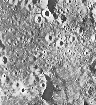
The Descartes Highlands is an area of lunar highlands located on the near side that served as the landing site of the American Apollo 16 mission in early 1972. The Descartes Highlands is located in the area surrounding Descartes crater, after which the feature received its name.

<span class="mw-page-title-main">Hadley–Apennine</span> Moon landing site of American Apollo 15

Hadley–Apennine is a region on the near side of Earth's Moon that served as the landing site for the American Apollo 15 mission, the fourth crewed landing on the Moon and the first of the "J-missions", in July 1971. The site is located on the eastern edge of Mare Imbrium on a lava plain known as Palus Putredinis. Hadley–Apennine is bordered by the Montes Apenninus, a mountain range, and Hadley Rille, a meandering channel, on the east and west, respectively.

<span class="mw-page-title-main">Big Muley</span> Largest lunar rock collected during the Apollo program

Lunar Sample 61016, better known as "Big Muley", is a lunar sample discovered and collected on the Apollo 16 mission in 1972 in the Descartes Highlands, on the rim of Plum crater, near Flag crater. It is the largest sample returned from the Moon as part of the Apollo program. The rock, an 11.7 kg (26 lb) breccia consisting mainly of shocked anorthosite attached to a fragment of troctolitic "melt rock", is named after Bill Muehlberger, the Apollo 16 field geology team leader.

<span class="mw-page-title-main">Shorty (crater)</span> Lunar crater

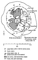
Shorty is a feature on Earth's Moon, an impact crater in the Taurus–Littrow valley. Astronauts Eugene Cernan and Harrison Schmitt visited it in 1972, on the Apollo 17 mission. It is the location of the famous "orange soil", which geologists believe to be small bits of rapidly-cooled molten rock ejected in a fire fountain. It is about 110 meters in diameter and up to 14 m (15 yd) deep.

Shorty Crater is about 14 m deep. Based on our investigations at the site and later examination of photographs, the impact that formed it penetrated, in order, regolith on the avalanche deposit, the avalanche deposit, regolith on a basalt flow, a basalt flow overlying and protecting the orange and black glass layers, the orange and black glass layers, regolith on a second basalt flow, and, finally, the upper portion of that second flow. Orange and black glass clods and basalt boulders are spread throughout the ejecta blanket surrounding Shorty.

<span class="mw-page-title-main">South Ray (crater)</span> Crater on the Moon

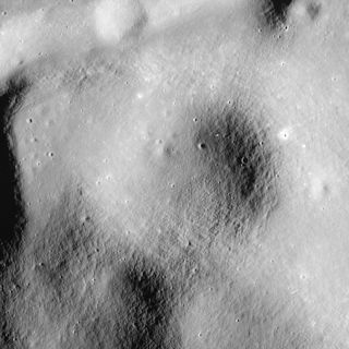
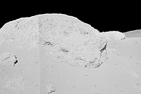
South Ray crater is a small crater in the Descartes Highlands of the Moon photographed from the lunar surface by the astronauts of Apollo 16. The name of the crater was formally adopted by the IAU in 1973.

<span class="mw-page-title-main">Palmetto (crater)</span> Crater on the Moon

Palmetto crater is a small crater in the Descartes Highlands of the Moon visited by the astronauts of Apollo 16. The name of the crater was formally adopted by the IAU in 1973.

<span class="mw-page-title-main">Camelot (crater)</span> Lunar impact crater

Camelot is a feature on Earth's Moon, a crater in Taurus-Littrow valley. Astronauts Eugene Cernan and Harrison Schmitt visited it in 1972, on the Apollo 17 mission, during EVA 2. Geology Station 5 was along the south rim of Camelot.

<span class="mw-page-title-main">Victory (crater)</span> Crater on the Moon

Victory is a feature on Earth's Moon, a crater in Taurus–Littrow valley. Astronauts Eugene Cernan and Harrison Schmitt visited it in 1972, on the Apollo 17 mission, during EVA 2. The astronauts stopped at the south rim of Victory on their way back to the Lunar Module from Shorty crater.

<span class="mw-page-title-main">Steno-Apollo</span> Crater on the Moon

Steno-Apollo is a feature on Earth's Moon, a crater in Taurus-Littrow valley. Astronauts Eugene Cernan and Harrison Schmitt visited it in 1972, on the Apollo 17 mission. The astronauts referred to it simply as Steno during the mission. The north rim of Steno is Geology Station 1 of the mission.

<span class="mw-page-title-main">Nansen-Apollo (crater)</span> Crater on the Moon

Nansen-Apollo is a feature on Earth's Moon, a crater in Taurus-Littrow valley, at the base of the South Massif. Astronauts Eugene Cernan and Harrison Schmitt visited it in 1972, on the Apollo 17 mission. The astronauts referred to it simply as Nansen during the mission. Geology Station 2 of the mission was located at Nansen. Nansen is located in the 'light mantle' which is almost certainly an avalanche deposit from the South Massif.

<span class="mw-page-title-main">Lara (lunar crater)</span> Crater on the Moon

Lara is a feature on Earth's Moon, a crater in Taurus-Littrow valley. Astronauts Eugene Cernan and Harrison Schmitt visited it in 1972, on the Apollo 17 mission, during EVA 2. Geology Station 3 of the mission is located on the northeast rim of Lara.

<span class="mw-page-title-main">Spur (lunar crater)</span> Surface depression on the Moon

Spur is a feature on Earth's Moon, a crater in the Hadley–Apennine region. Astronauts David Scott and James Irwin visited it in 1971, on the Apollo 15 mission, during EVA 2. Spur was designated Geology Station 7.

<span class="mw-page-title-main">Flag (crater)</span> Lunar crater explored on Apollo 16

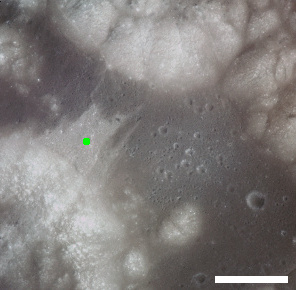
Flag crater is a small crater in the Descartes Highlands of the Moon visited by the astronauts of Apollo 16. The name of the crater was formally adopted by the IAU in 1973. Geology Station 1 is adjacent to Flag, at the much smaller Plum crater.

<span class="mw-page-title-main">Spook (crater)</span> Lunar crater explored on Apollo 16

Spook crater is a small crater in the Descartes Highlands of the Moon visited by the astronauts of Apollo 16. The name of the crater was formally adopted by the IAU in 1973. Geology Station 2 is adjacent to Spook, between it and the smaller, younger crater called Buster to the north of it.

<span class="mw-page-title-main">St. George (crater)</span> Crater on the Moon

St. George is a feature on Earth's Moon, a crater in the Hadley–Apennine region. Astronauts David Scott and James Irwin drove their rover onto what was suspected to be its ejecta blanket in 1971, on the Apollo 15 mission, during EVA 1. They collected samples to the northeast of the crater, at Geology Station 2 of the mission.

<span class="mw-page-title-main">Cinco (crater)</span> Crater on the Moon

Cinco is a small crater in the Descartes Highlands of the Moon visited by the astronauts of Apollo 16. The crater is one of a group of five (hence the name, Spanish for five) craters that were collectively called the Cinco craters during the Apollo 16 mission. The craters were designated a, b, c, d, and e, and the largest (a) was officially named Cinco after the mission in 1973 by the IAU.

<span class="mw-page-title-main">Head (crater)</span> Crater on the Moon

Head crater is a small crater in Mare Cognitum on the Moon. The name of the crater was formally adopted by the IAU in 1973.

<span class="mw-page-title-main">Cone (crater)</span> Crater on the Moon

Cone crater is a small crater in the Fra Mauro highlands, north of Fra Mauro crater, on the Moon. The name of the crater was formally adopted by the IAU in 1973.

References

  1. 1 2 North Ray, Gazetteer of Planetary Nomenclature, International Astronomical Union (IAU) Working Group for Planetary System Nomenclature (WGPSN)
  2. Apollo 16 Landing Area, 78D2S1(50), NASA Lunar Topophotomap. Published by The Defense Mapping Agency, November 1974. Available from Lunar and Planetary Institute.
  3. 1 2 Apollo 16 Preliminary Science Report (NASA SP-315), 1972
  4. Geologic Map of the Apollo 16 (Descartes) Landing Area by Apollo Field Geology Investigation Team (D. P. Elston, E. L. Boudette, J. P. Schafer), United States Geological Survey, April 1972
  5. 67955 Summary Sheet available from Lunar and Planetary Institute
  6. Drozd R.J., Hohenberg C.M., Morgan C.J. and Ralston C.E. (1974) Cosmic-ray exposure history at the Apollo 16 and other lunar sites: lunar surface dynamics. Geochim. Cosmochim. Acta 38, 1625-1642.
  7. Norman M.D., Shih C.-Y., Nyquist L.E., Bogard D.D. and Taylor L.A. (2007) Early impacts on the moon: Crystallization ages of Apollo 16 melt breccias (abs#1991). Lunar Planet. Sci. XXXVIII Lunar & Planetary Institute, Houston. (LPSC 2007 web page)
  8. Lunar Sample Atlas, Lunar and Planetary Institute