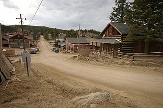
Gold Hill is an unincorporated community and a census-designated place (CDP) located in and governed by Boulder County, Colorado, United States. The CDP is a part of the Boulder, CO Metropolitan Statistical Area. The population of the Gold Hill CDP was 230 at the United States Census 2010. The Boulder post office serves the area.

Aiea is a census-designated place (CDP) located in the City and County of Honolulu, Hawaii, United States. As of the 2010 Census, the CDP had a total population of 9,338.

Halawa is a census-designated place (CDP) in the ‘Ewa District of Honolulu County, Hawaii, United States. Halawa Stream branches into two valleys: North and South Halawa; North Halawa is the larger stream and fluvial feature. Their confluence is within the H-3/H-201 highways exchange. Most of Halawa Valley is undeveloped. As of the 2020 census, the CDP had a population of 15,016.
Ferdinand is a town in Ferdinand Township, Dubois County, in the U.S. state of Indiana. The population was 2,157 at the 2010 census.
Green Harbor-Cedar Crest was a census-designated place (CDP) in the towns of Duxbury and Marshfield in Plymouth County, United States. It included the village of Green Harbor, on the shore of Massachusetts Bay, and the community of Cedar Crest, occupying a hill on the north side of Careswell Street. The population of the CDP was 2,609 at the 2010 census. Prior to the 2020 census the area was split into two CDPs, Green Harbor and Cedar Crest.

Cedar Hill is an unincorporated community and census-designated place (CDP) in northwest Jefferson County, Missouri, United States. The population was 1,721 at the 2010 census.

Cedar Crest is a census-designated place (CDP) in Bernalillo County, New Mexico, United States. The population was 958 at the 2010 census. It is part of the Albuquerque Metropolitan Statistical Area.

Miller Place is a hamlet and census-designated place (CDP) in the Town of Brookhaven, Suffolk County, New York, United States, on the North Shore of Long Island. Miller Place has been inhabited since the 17th century and is named for the Miller family that included many of its initial settlers. For most of its history, the community functioned as an agriculture-based society. Despite preserving much of its historic identity, changes in the 20th century have transitioned the hamlet into a desirable and densely populated suburban area. The population was 11,723 at the 2020 census.

Mount Sinai is a hamlet and census-designated place (CDP) located within the Town of Brookhaven, in Suffolk County, New York, United States. The population was 12,118 at the 2010 census. The hamlet is located on the North Shore of Long Island.

Marshfield is a town in Plymouth County, Massachusetts, United States, on Massachusetts's South Shore. The population was 25,825 at the 2020 census.
Seabrook is an unincorporated community and census-designated place (CDP) in Prince George's County, Maryland, United States, located approximately 12 miles (19 km) east of Washington. Per the 2020 census, the population was 19,627. Prior to 2010, Seabrook was part of the Lanham-Seabrook census-designated place.
Agua Dulce is a census-designated place in Los Angeles County, California, United States. It lies at an elevation of 2,526 feet (770 m), northeast of Santa Clarita. The community had a population of 3,342 at the 2010 census and covers a geographic area of about 23 square miles (59 km2). Agua Dulce is on the Pacific Crest Trail. The ZIP code is 91390, and the area code is 661.

Jefferson is an unincorporated community and census-designated place (CDP) in Frederick County, Maryland, United States. As of the 2020 census the town had a population of 2,235. Jefferson was established in 1774 and incorporated as a town in 1831. However, a year later, in 1832, the citizens of the town decided that municipal government was unnecessary, and dis-incorporated the town, which has been unincorporated since then.
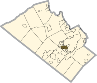
Dorneyville is a census-designated place in Lehigh County, Pennsylvania, United States. It is part of the Lehigh Valley metropolitan area of the United States.
Sequoia Crest is a census-designated place (CDP) in Tulare County, California.The community of Sequoia Crest contains more than 150 Giant Sequoias scattered throughout the subdivision. Sequoia Crest sits at an elevation of 7,008 feet (2,136 m). The 2010 United States census reported Sequoia Crest's population was 10. Sequoia Crest can be reached from Porterville by 41 curvy miles most on California State Route 190 with an elevation gain of 6,549 feet.

Clinton is a town in Middlesex County, Connecticut, United States. The population of the town was 13,185 at the 2020 census. The town center along the shore line was listed as a census-designated place (CDP) by the U.S. Census Bureau in the 2020 census.
Charlestown is a census-designated place (CDP) in Washington County, Rhode Island, United States, comprising the main village in the town of Charlestown and additional land extending to the east into the town of South Kingstown. It was first listed as a CDP prior to the 2020 census.
Sail Harbor is a census-designated place (CDP) in the towns of New Fairfield and Sherman, Fairfield County, Connecticut, United States. It is in the northeast corner of New Fairfield and the southeast corner of Sherman, on Great Neck and Shelter Harbor, landforms on the west side of Candlewood Lake. It is bordered to the west by Inglenook.

Green Harbor is a census-designated place (CDP) in the towns of Marshfield and Duxbury, Plymouth County, Massachusetts, United States. It was first listed as a CDP prior to the 2020 census. At the 2010 census the community was included with neighboring Cedar Crest in a single CDP.
Bent Tree Harbor is an unincorporated community and census-designated place (CDP) in Benton County, Missouri, United States. It is in the western part of the county, on the north side of State Highway Z, 6 miles (10 km) west of Warsaw, the county seat. It is bordered to the northwest and northeast by arms of Harry S. Truman Reservoir on the South Grand River, a tributary of the Osage River.


