
Cape Cod is an arm-shaped peninsula extending into the Atlantic Ocean from the southeastern corner of Massachusetts, in the northeastern United States. Its historic, maritime character and ample beaches attract heavy tourism during the summer months. The name Cape Cod, coined in 1602 by Bartholomew Gosnold, is the ninth oldest English place-name in the U.S.

Woods Hole is a census-designated place in the town of Falmouth in Barnstable County, Massachusetts, United States. It lies at the extreme southwest corner of Cape Cod, near Martha's Vineyard and the Elizabeth Islands. The population was 781 at the 2010 census. The eminent Hungarian born biochemist and Nobel prize laureate, Albert Imre Szent-Györgyi de Nagyrápolt died here in 1986.
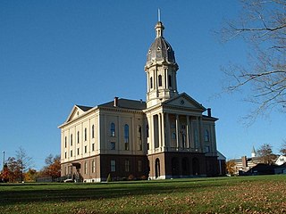
Middleborough is a town in Plymouth County, Massachusetts, United States. The population was 24,245 at the 2020 census. The census-designated place of Middleborough Center corresponds to the main village and commercial center of the town. It is the second largest municipality by land area in Massachusetts and nineteenth largest in New England. Middleborough proclaims itself to be the "Cranberry Capital of the World". Cranberry production remains a significant part of the local economy. In 2015, approximately 1,400 acres of the town were used to grow the crop, accounting for 3% of all land used to harvest cranberry bogs in the United States.

Bourne is a town in Barnstable County, Massachusetts, United States. The population was 20,452 at the 2020 census.

Brewster is a town in Barnstable County, Massachusetts, United States, Barnstable County being coextensive with Cape Cod. The population of Brewster was 10,318 at the 2020 census.

Plymouth is a town and county seat of Plymouth County, Massachusetts, United States. Located in Greater Boston, the town holds a place of great prominence in American history, folklore, and culture, and is known as "America's Hometown". Plymouth was the site of the colony founded in 1620 by the Mayflower Pilgrims, where New England was first established. It is the oldest municipality in New England and one of the oldest in the United States. The town has served as the location of several prominent events, one of the more notable being the First Thanksgiving feast. Plymouth served as the capital of Plymouth Colony from its founding in 1620 until the colony's merger with the Massachusetts Bay Colony in 1691. The English explorer John Smith named the area Plymouth and the region 'New England' during his voyage of 1614. It was a later coincidence that, after an aborted attempt to make the 1620 trans-Atlantic crossing from Southampton, the Mayflower finally set sail for America from Plymouth, England.
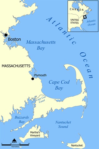
Cape Cod Bay is a large bay of the Atlantic Ocean adjacent to the U.S. state of Massachusetts. Measuring 604 square miles (1,560 km2) below a line drawn from Brant Rock in Marshfield to Race Point in Provincetown, Massachusetts, it is enclosed by Cape Cod to the south and east, and Plymouth County, Massachusetts, to the west. To the north of Cape Cod Bay lie Massachusetts Bay and the Atlantic Ocean. Cape Cod Bay is the southernmost extremity of the Gulf of Maine. Cape Cod Bay is one of the bays adjacent to Massachusetts that give it the name Bay State. The others are Narragansett Bay, Buzzards Bay, and Massachusetts Bay.

Route 3A is a 97-mile-long (156 km) state highway in eastern Massachusetts, which parallels Route 3 and U.S. Route 3 from Cedarville in southern Plymouth to Tyngsborough at the New Hampshire state line.

Waquoit Bay is a public national estuary, which is typically used as a research reserve. It is a part of Nantucket Sound and is located on the southern shore of Cape Cod in Massachusetts, USA. This bay forms the border of the towns of Falmouth and Mashpee, Massachusetts.
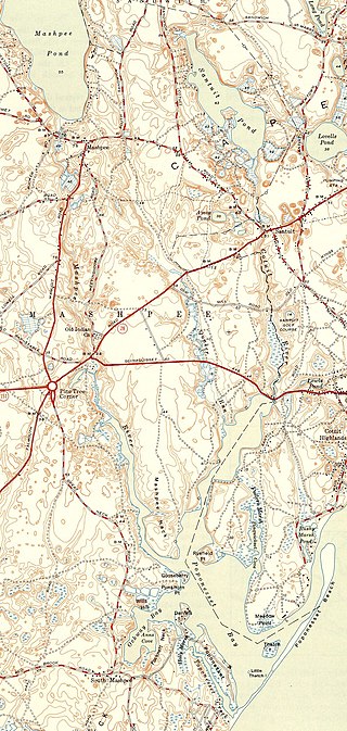
The Santuit River, also known as the Cotuit River, is a 2.3-mile-long (3.7 km) river on the border between Mashpee and Cotuit, Massachusetts on Cape Cod.
The Coonamessett River, is a largely groundwater fed coastal river in Falmouth, Massachusetts, on Cape Cod.

Plymouth Bay is a small, well-protected bay of the Atlantic Ocean on the western shore of larger Cape Cod Bay along the coastline of the Commonwealth of Massachusetts. Plymouth Bay retains historical significance for the landing at Plymouth Rock in 1620 by the Pilgrims aboard the Mayflower who proceeded to establish the first permanent Northern European settlement in North America at Plymouth Colony.

There are several neighborhoods in Plymouth, Massachusetts. With a total area of 134.0 mi2 (347.0 km2), Plymouth is the largest municipality in Massachusetts by area. In addition, with a population of 51,701 at the 2000 census and an estimated population of 57,901 in 2007, Plymouth is the second-largest town in the state by population (after Framingham. As such, Plymouth is home to many distinct neighborhoods and geographical locations.
South Plymouth is the portion of Plymouth, Massachusetts, United States that covers much of the southern section of the town, beginning at the Pine Hills, a large, mostly undeveloped forested area south of Plymouth Beach, Chiltonville and South Pond. The remainder of the section is south and east of the northeastern entrance to Myles Standish State Forest, stretching to the Bourne and Wareham town lines.

Ellisville is a village in southeastern Plymouth, Massachusetts, United States. It is located on Cape Cod Bay, and is situated south of Vallerville and north of Cedarville. The neighborhoods within Ellisville include Harlow's Landing and Eastland Heights. Ellisville Harbor State Park, in the northern part of the village, has a natural harbor and beach.

Town Brook is a 1.5-mile (2.4 km) stream in Plymouth, Massachusetts that provided drinking water to the Pilgrims who made their homes adjacent to the brook on Leyden Street in Plymouth. Town Brook's headwaters are the Billington Sea, a 269-acre (109 ha) freshwater pond. The brook passes through numerous small ponds, including Deep Water Pond and Jenny Pond. It also passes by the Plimoth Grist Mill and the Brewster Gardens before emptying into Plymouth Harbor. A nature trail runs along the entire length of the brook.

Hedges Pond is a 26-acre (110,000 m2) pond in the Cedarville section of Plymouth, Massachusetts with access from Hedges Pond Rd. The pond is located more than one mile (1.6 km) north of Cedarville's business district past the Route 3 underpass, southeast of Black Jimmy Pond, and east of Little Herring Pond. Hedges Pond has no private residences on its shores.

Nickerson State Park is a state-owned, public recreation area of more than 1,900 acres (770 ha) located on Cape Cod in Brewster, Massachusetts. The park's sandy soil and scrub pines surround many kettle ponds which are dependent on groundwater and precipitation. The largest of these are Cliff Pond, Flax Pond, Little Cliff Pond, and Higgins Pond. Ruth Pond, Keeler's Pond, Eel Pond, and Triangle Pond provide additional water habitats.

Sarah Pratt McLean Greene was an American regionalist writer whose novels of local life were set in New England and the western United States. She published her earlier books as Sally Pratt McLean and later books as Sarah P. McLean Greene.


