
Lubuklinggau, is a city in South Sumatra, Indonesia. It has an area of 401.50 km² and had a population of 201,308 at the 2010 Census and 234,166 at the 2020 Census; the official estimate as at mid 2022 was 240,238. The city was formerly part of the Musi Rawas Regency from which it was separated on 21 June 2001.
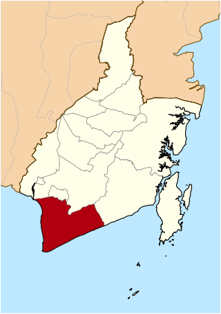
Tanah Laut Regency is one of the regencies in the Indonesian province of South Kalimantan. It encompasses the southernmost part of Kalimantan (Borneo). The area is 3,631.35 km2, and the population was 296,333 at the 2010 Census and 348,966 at the 2020 Census; the official estimate as at mid 2022 was 361,044. The capital is the town of Pelaihari. Motto: "Tuntung Pandang" (Banjarese). Tuntung Pandang have meaning as "nice to see until forever"

Rejang Lebong is a regency of Bengkulu Province, Indonesia, on the island of Sumatra. This regency originally included a much larger part of the inland distyrict of the province, but on 25 February 2003 it was divided in three, with districts in the northwest being split off to form a separate Lebong Regency, and districts in the south being similarly split off to form a new Kepahiang Regency. The residual Rejang Lebong Regency now covers 1,550.28 km² and had a population of 246,787 at the 2010 Census and 276,645 at the 2020 Census; the official estimate as at mid 2022 was 281,281. The administrative centre of the Rejang Lebong Regency is the town of Curup. The Rejangese people are the most numerous ethnic group in Bengkulu Province, and inhabit the western half of the Regency, while the Lembak people inhabit the eastern half.

North Bengkulu is a regency of Bengkulu Province, Indonesia, on the island of Sumatra. It originally covered much of the northern part of Bengkulu Province, but on 25 February 2003 the most northwesterly districts were split off to form a separate Mukomuko Regency, and on 24 June 2008 the most southeastern districts were likewise split off to create a new Central Bengkulu Regency. The residual regency now covers an area of 4,424.59 km2, and it had a population of 257,675 at the 2010 Census and 296,523 at the 2020 Census; the official estimate as at mid 2022 was 302,833. The administrative centre is at the town of Arga Makmur.

South Bengkulu is a regency of Bengkulu Province, Indonesia, on the island of Sumatra. It originally comprised all of that part of Bengkulu Province situated to the southeast of the city of Bengkulu, but on 25 February 2003 this area was split into three parts, with the most southeastern districts split off to form a new Kaur Regency and the most northwestern districts split off to form a new Seluma Regency. The reduced South Bengkulu Regency now covers 1,186.10 km2, and had a population of 142,940 at the 2010 Census and 166,249 at the 2020 Census; the official estimate as at mid 2022 was 170,093. The regency's administrative centre is the coastal town of Manna.
Mukomuko is a regency of Bengkulu Province, Indonesia, on the island of Sumatra. It was originally part of the North Bengkulu Regency, but on 25 February 2003 that regency was split into two parts, the northwestern part created as a separate Mukomuko Regency. It covers a land area of 4,146.52 km2 and had a population of 155,753 at the 2010 census, which rose to 190,498 at the 2020 census; the official estimate as at mid 2022 was 196,571. The administrative centre of the Mukomuko Regency is Mukomuko town.

Musi Banyuasin Regency is a regency of South Sumatra province, in Indonesia. Originally much larger, it was reduced by about 45% of its former area on 10 April 2002 by the splitting off of most of its eastern and northeastern districts to form the new Banyuasin Regency. It now has a total area of 14,265.96 km2 (5,508 sq mi) and a population of 561,458 at the 2010 Census and 622,206 at the 2020 Census; the official estimate as at mid 2022 was 633,124.

Merangin is a regency (kabupaten) of Jambi Province on the island of Sumatra, Indonesia. It was created on 4 October 1999 by the division of the former Sarolangun Bangko Regency into a new Sarolangun Regency and this Merangin Regency. The regency covers an area of 7,668.61 km2, and had a population of 333,206 at the 2010 census and 354,052 at the 2020 census; the official estimate as at mid 2022 was 357,577, comprising 181,850 males and 175,727 females. The administrative capital is the town of Bangko.

Sarolangun Regency is a regency of Jambi Province, Indonesia. It is located on the island of Sumatra. It was created on 4 October 1999 by the division of the former Sarolangun Bangko Regency into a new Merangin Regency and this Sarolangun Regency. The regency has an area of 5941.13 km2 and had a population of 246,245 at the 2010 census and 290,047 at the 2020 census; the official estimate as at mid 2022 was 298,091. The administrative centre is at the town of Sarolangun.

West Tanjung Jabung Regency is a regency of Jambi Province, Indonesia. It is located on the island of Sumatra. The regency was created on 4 October 1999 by the division of the then Tanjung Jabung Regency into eastern and western halves. It now has an area of 5,009.82 km2 and had a population of 278,741 as at the 2010 census and 317,498 at the 2020 census; the official estimate as at mid 2022 was 326,530. The regency seat is Kuala Tungkal.

Tebo Regency is a regency of Jambi Province, Indonesia. It is located on the island of Sumatra, and was created on 4 October 1999 by the division of the former Bungo Tebo Regency into a new Bungo Regency and this Tebo Regency. The regency has an area of 6,461 km² and had a population of 297,735 at the 2010 Census and 337,669 at the 2020 Census; the official estimate as at mid 2022 was 344,816. The regency seat is at the town of Muara Tebo.

Kaur is the most southern regency of Bengkulu Province, Indonesia, on the west coast of the island of Sumatra. It was created on 25 February 2003 from what were formerly the southeastern districts of the South Bengkulu Regency. It has an area of 2,365.00 km2 and had a population of 107,899 at the 2020 Census and 126,551 at the 2020 Census; the official estimate as at mid 2022 was 129,661. The regency seat is at the town of Bintuhan.

Lebong is an inland regency of Bengkulu Province, Indonesia, on the island of Sumatra. It covers an area of 1,665.28 km2, and had a population of 97,091 at the 2010 Census and 106,293 at the 2020 Census; the official estimate as at mid 2022 was 107,248. Contrary to the popularly-held belief that the town of Muara Aman is the seat of the government of Lebong Regency, the regency's capital is actually located in neighboring Tubei district, where all the office and judiciary institution is situated. Until 1966 the regency, together with the rest of what is now Bengkulu Province, was part of South Sumatra Province. It formed part of Rejang Lebong Regency until 25 February 2003, when the northwestern districts of that regency were split off to create the new Lebong Regency.

Seluma Regency is a regency of Bengkulu Province, Indonesia, on the west coast of the island of Sumatra. It was created on 25 February 2003 from what were formerly the northwestern districts of the South Bengkulu Regency. The regency seat is at the town of Pasar Tais. It covers an area of 2,479.36 km2, and had a population of 173,507 at the 2010 Census and 207,877 at the 2020 Census; the official estimate as at mid 2022 was 213,755.

South Ogan Komering Ulu Regency is a regency in the far south of South Sumatra Province, Indonesia. It was created on 18 December 2003 from what had previously been the southernmost districts of Ogan Komering Ulu Regency. It covers an area of 5,493.94 km2, and had a population of 318,428 at the 2010 Census and 408,981 at the 2020 Census; the official estimate as at mid 2022 was 426,687. The administrative centre is the town of Muaradua. It borders Ogan Komering Ulu Regency, East Ogan Komering Ulu Regency and Muara Enim Regency to the north. It also borders Lampung Province to the south and east and Bengkulu Province to the west.

Tanggamus Regency is a regency (kabupaten) of Lampung Province, Sumatra, Indonesia. It has an area of 4,654.96 km² and had a population of 534,595 at the 2010 Census and 640,275 at the 2020 Census; the official estimate as at mid 2022 was 652,898. The regency seat is the town of Kota Agung Pusat. The regency was created on 21 March 1997, but districts in its eastern part were split away on 29 October 2008 to form a new Pringsewu Regency. It lies in the southwest of the province, and surrounds Semangka Bay on its west, north and east coasts.

West Tulang Bawang Regency is a regency (kabupaten) of Lampung Province, Sumatra, Indonesia. It was created on 29 October 2008 from what were formerly the western districts of Tulang Bawang Regency. It has an area of 1,201.15 km2 and had a population of 250,707 people at the 2010 Census and 286,162 at the 2020 Census; the official estimate as at mid 2022 was 289,620. The regency seat is the town of Panaragan Jaya.

Way Kanan Regency is a landlocked regency (kabupaten) of Lampung Province, Sumatra, Indonesia. It was created on 20 April 1999 from what were formerly the northern districts of North Lampung Regency. It has an area of 3,921.63 km2 and had a population of 406,123 at the 2010 census and 473,575 at the 2020 census; the official estimate as at mid 2022 was 481,036. The administrative centre lies at the town of Blambangan Umpu.

Barru Regency is a regency of South Sulawesi Province of Indonesia. It covers an area of 1,174.72 km2 and had a population of 165,983 at the 2010 Census and 184,452 at the 2020 Census; the official estimate as at mid 2022 was 186,910. The principal town lies at Barru.

North Musi Rawas Regency is a regency of South Sumatra Province, Indonesia. It takes its name from the two main river which drain that area, Musi River and Rawas River. This regency was created on 10 June 2013 by splitting off the seven northernmost districts of Musi Rawas Regency.


