
Chester County is a county in the Commonwealth of Pennsylvania. It is located in the Delaware Valley region, located in the southeastern part of the state. As of the 2020 census, the population was 534,413, increasing by 7.1% from 498,886 in 2010. The county seat and most populated municipality is West Chester. Chester County was one of the three original Pennsylvania counties created by William Penn in 1682. It was named for Chester, England.
Birmingham Township is a township in Chester County, Pennsylvania, United States. The population was 4,085 at the 2020 census.

East Brandywine Township is a township in Chester County, Pennsylvania, United States. The population was 9,746 at the 2020 census.

Pennsbury Township is a township in Chester County, Pennsylvania, United States. The population was 3,604 at the 2010 census.

Pocopson Township is a township in Chester County, Pennsylvania, United States. The population was 4,582 at the 2010 census.

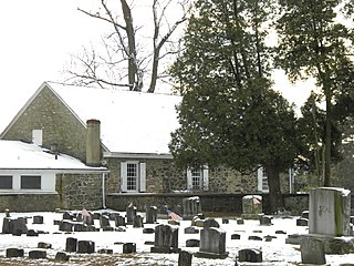
Thornbury Township is a township in Chester County, Pennsylvania, United States. The population was 3,017 at the 2010 census. It is adjacent to, and was once joined with, Thornbury Township, Delaware County.

Concord Township is a township in Delaware County, Pennsylvania, United States. The population was 17,231 at the 2010 census. It contains the unincorporated communities of Concordville and Glen Mills.

Middletown Township is a township in Delaware County, Pennsylvania, United States. The population was 15,807 at the 2010 census. The Pennsylvania State University has an undergraduate satellite campus called Penn State Brandywine located in the north-central portion of the township. Located outside of Philadelphia, it constitutes part of the Delaware Valley.
Thornbury Township is a township in Delaware County, Pennsylvania, United States. As of the 2010 U.S. census, the population was 8,028, up from 7,093 at the 2000 census. It is adjacent to, and was once joined with, Thornbury Township in Chester County. It includes part of the census designated place of Cheyney University.
Brownstown is an unincorporated community and census-designated place (CDP) in West Earl Township, Lancaster County, Pennsylvania, United States. As of the 2010 census, the population was 2,816.

The Battle of Brandywine, also known as the Battle of Brandywine Creek, was fought between the American Continental Army of General George Washington and the British Army of General Sir William Howe on September 11, 1777, as part of the American Revolutionary War (1775–1783). The forces met near Chadds Ford, Pennsylvania. More troops fought at Brandywine than at any other battle of the American Revolution. It was also the second longest single-day battle of the war, after the Battle of Monmouth, with continuous fighting for 11 hours.

Brandywine Creek is a tributary of the Christina River in southeastern Pennsylvania and northern Delaware in the United States. The Lower Brandywine is 20.4 miles (32.8 km) long and is a designated Pennsylvania Scenic River with several tributary streams. The East Branch and West Branch of the creek originate within 2 miles (3 km) of each other on the slopes of Welsh Mountain in Honey Brook Township, Pennsylvania, about 20 miles (32 km) northwest of their confluence.

Chadds Ford Township is an affluent township in Delaware County, Pennsylvania, United States. It is located about 25 miles (40 km) southwest of Philadelphia.

Pennsylvania Route 52 is a 11.8-mile-long (19.0 km) state highway located in southeast Pennsylvania. The southern terminus of the route is at the Pennsylvania-Delaware state line near Kennett Square, where the road continues as Delaware Route 52. The northern terminus is at U.S. Route 322 Business in West Chester. Near the Kennett Township community of Longwood, it has about a 1-mile (1.6 km) wrong-way concurrency with US 1. PA 52 passes through suburban and rural areas along its route.
Unionville is an unincorporated community and census-designated place in East Marlborough Township in southern Chester County, Pennsylvania, United States. It was originally known as Jacksonville. The Unionville Village Historic District was added to the National Register of Historic Places in 1979. As of 2020, the CDP has a population of 577.
The Brandywine Battlefield Historic Site is a National Historical Landmark. The historic park is owned and operated by the Pennsylvania Historical and Museum Commission, on 52 acres (210,000 m2), near Chadds Ford, Delaware County, Pennsylvania in the United States.

Pennsylvania House of Representatives District 160 includes parts of Chester County and Delaware County. It is currently represented by Republican Craig Williams.

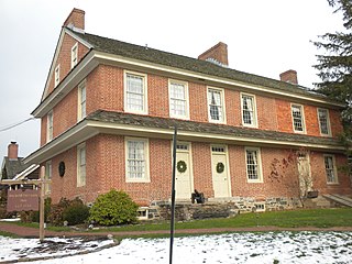
The Barns-Brinton House is an historic brick house located between Hamorton and Chadds Ford, Pennsylvania in Pennsbury Township, Chester County, Pennsylvania. It was constructed in 1714 by William Barns, who operated it as a tavern from 1722 until his death in 1731.
Dilworthtown is an unincorporated community and census-designated place (CDP) in Chester and Delaware counties, Pennsylvania, United States. It was first listed as a CDP prior to the 2020 census.

Hamorton is an unincorporated community and census-designated place (CDP) in Chester County, Pennsylvania, United States. It was first listed as a CDP prior to the 2020 census.


