Village Green-Green Ridge, Pennsylvania

Last updated

Village Green-Green Ridge
Delaware County Pennsylvania incorporated and unincorporated areas Village Green-Green Ridge highlighted.svg
Location in Delaware County and the U.S. state of Pennsylvania
Coordinates: 39°51′50″N75°25′28″W / 39.86389°N 75.42444°W / 39.86389; -75.42444
CountryUnited States
StatePennsylvania
County Delaware
Township Aston
Area
  Total1.9 sq mi (5 km2)
  Land1.9 sq mi (5 km2)
  Water0.0 sq mi (0 km2)
Elevation
220 ft (70 m)
Population
 (2010)
  Total7,822
  Density4,100/sq mi (1,600/km2)
Time zone UTC-5 (EST)
  Summer (DST) UTC-4 (EDT)
Area code 610
FIPS code 42-80218
GNIS feature ID2390436

Village Green-Green Ridge is a census-designated place (CDP) in Delaware County, Pennsylvania, United States. The population was 7,822 at the 2010 census, [1] down from 8,279 at the 2000 census.

Contents

Geography

Village Green-Green Ridge is located in southern Delaware County at 39°51′50″N75°25′28″W / 39.86389°N 75.42444°W / 39.86389; -75.42444 (39.864011, -75.424499), [2] in the southern part of Aston Township. Pennsylvania Route 452 (Pennell Road) passes through the center of the CDP, leading north 3.5 miles (5.6 km) to Lima and south 3.5 miles (5.6 km) to Marcus Hook. Chester is 4 miles (6 km) to the southeast via Concord Road.

According to the United States Census Bureau, the CDP has a total area of 1.9 square miles (4.8 km2), all land. [1]

Demographics

Historical population
CensusPop.Note
2000 8,279
2010 7,822−5.5%
2020 8,0002.3%
source: [3] [4]

As of the census [5] of 2000, there were 8,279 people, 3,165 households, and 2,294 families residing in the CDP. The population density was 4,527.7 inhabitants per square mile (1,748.2/km2). There were 3,218 housing units at an average density of 1,759.9 per square mile (679.5/km2). The racial makeup of the CDP was 97.61% White, 0.60% African American, 0.02% Native American, 0.76% Asian, 0.02% Pacific Islander, 0.25% from other races, and 0.72% from two or more races. Hispanic or Latino of any race were 1.11% of the population.

There were 3,165 households, out of which 29.8% had children under the age of 18 living with them, 59.8% were married couples living together, 9.1% had a female householder with no husband present, and 27.5% were non-families. 24.1% of all households were made up of individuals, and 13.6% had someone living alone who was 65 years of age or older. The average household size was 2.61 and the average family size was 3.12.

In the CDP, the population was spread out, with 22.4% under the age of 18, 8.0% from 18 to 24, 27.0% from 25 to 44, 25.3% from 45 to 64, and 17.2% who were 65 years of age or older. The median age was 40 years. For every 100 females, there were 92.5 males. For every 100 females age 18 and over, there were 88.6 males.

The median income for a household in the CDP was $50,369, and the median income for a family was $62,500. Males had a median income of $44,803 versus $30,809 for females. The per capita income for the CDP was $23,373. About 2.9% of families and 3.7% of the population were below the poverty line, including 6.1% of those under age 18 and 2.4% of those age 65 or over.

Related Research Articles

<span class="mw-page-title-main">Beckett Ridge, Ohio</span> Census-designated place in Ohio, United States

Beckett Ridge is a census-designated place (CDP) in West Chester Township, Butler County, Ohio, United States. The population was 9,187 at the 2010 census.

Spring Ridge is a census-designated place (CDP) in Spring Township, Berks County, Pennsylvania, United States. The population was 1,003 at the 2010 census.

<span class="mw-page-title-main">Tresckow, Pennsylvania</span> Census-designated place in Pennsylvania, United States

Tresckow, formerly known as Dutchtown, is an unincorporated community and census-designated place (CDP) in Carbon County, Pennsylvania, United States. It is part of Northeastern Pennsylvania and is located west of Junedale and Beaver Meadows, which share the same road network. The community has deep roots in the anthracite coal mining and transportation industries.

<span class="mw-page-title-main">Sandy Ridge, Pennsylvania</span> Census-designated place in Pennsylvania, United States

Sandy Ridge is an unincorporated community and census-designated place (CDP) in Centre County, Pennsylvania, United States. It is part of the State College, Pennsylvania Metropolitan Statistical Area. The population was 407 at the 2010 census.

<span class="mw-page-title-main">Thorndale, Pennsylvania</span> Census-designated place in Pennsylvania, United States

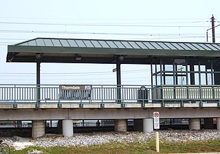
Thorndale is a census-designated place in Chester County, Pennsylvania, United States. The population was 3,407 at the 2010 census. Thorndale is the commercial and administrative center of Caln Township. The community's main street is U.S. Route 30 Business. Many of Thorndale's old houses fell into disrepair from the late 1990s to present and have been torn down and replaced with new businesses. Thorndale is historically notable for containing a summer house of US President James Buchanan, which still stands and has been incorporated into a golf course and turned into a restaurant. The community contains the Thorndale Fire Station and Caln Elementary School, part of the Coatesville Area School District. Thorndale sits along SEPTA's Paoli/Thorndale Line and is currently the last station stop on that line. It is also served by the SEPTA Route 135 bus.

West Goshen was a census-designated place (CDP) in West Goshen Township, Chester County, Pennsylvania, United States. The population was 8,472 at the 2000 census. The CDP was not delineated for the 2010 census.

<span class="mw-page-title-main">Numidia, Pennsylvania</span> Census-designated place in Pennsylvania, United States

Numidia is a census-designated place (CDP) in Columbia County, Pennsylvania, United States. It is part of Northeastern Pennsylvania. The population was 244 at the 2010 census. It is part of the Bloomsburg-Berwick metropolitan area.

<span class="mw-page-title-main">Northwest Harborcreek, Pennsylvania</span> Census-designated place in Pennsylvania, United States

Northwest Harborcreek is a census-designated place (CDP) in Erie County, Pennsylvania, United States. The population was 8,949 at the 2010 census. It includes the unincorporated communities of Fairfield and Brookside and is part of the Erie Metropolitan Statistical Area.

<span class="mw-page-title-main">Oliver, Pennsylvania</span> Census-designated place in Pennsylvania, United States

Oliver is a census-designated place (CDP) in Fayette County, Pennsylvania, United States. The population was 2,535 at the 2010 census, down from 2,925 at the 2000 census. Oliver is located in North Union Township.

<span class="mw-page-title-main">Republic, Pennsylvania</span> Census-designated place in Pennsylvania, United States

Republic is an unincorporated community and census-designated place (CDP) in Fayette County, Pennsylvania, United States. The population was 1,096 at the 2010 census, down from 1,396 at the 2000 census. The community is in Redstone Township.

Rouzerville is an unincorporated community and census-designated place (CDP) in Franklin County, Pennsylvania, United States. The population was 903 at the 2020 census.

Mount Cobb is an unincorporated community and census-designated place (CDP) in Lackawanna County, Pennsylvania, United States. The population was 1,799 at the 2010 census.

<span class="mw-page-title-main">Schnecksville, Pennsylvania</span> Census-designated place in Pennsylvania, United States

Schnecksville is an unincorporated community and census-designated place (CDP) in North Whitehall Township in Lehigh County, Pennsylvania. The population of Schnecksville was 2,935 at the 2010 census.

<span class="mw-page-title-main">Mountain Top, Pennsylvania</span> Census-designated place in Pennsylvania, United States

Mountain Top is an unincorporated area and census-designated place (CDP) in Luzerne County, Pennsylvania, United States. As of the 2010 census, the CDP population was 10,982.

<span class="mw-page-title-main">Pottsgrove, Pennsylvania</span> Census-designated place in Pennsylvania, United States

Pottsgrove is a census-designated place (CDP) in Montgomery County, Pennsylvania, United States. The population was 3,469 at the 2010 census.

<span class="mw-page-title-main">Grantley, Pennsylvania</span> CDP in Pennsylvania, United States

Grantley is a census-designated place (CDP) in York County, Pennsylvania, United States. The population was 3,628 at the 2010 census.

<span class="mw-page-title-main">Susquehanna Trails, Pennsylvania</span> CDP in Pennsylvania, United States

Susquehanna Trails is a census-designated place (CDP) in York County, Pennsylvania, United States. The population was 2,264 at the 2010 census.

<span class="mw-page-title-main">Weigelstown, Pennsylvania</span> CDP in Pennsylvania, United States

Weigelstown is a census-designated place (CDP) in York County, Pennsylvania, United States. The population was 12,875 at the 2010 census.

<span class="mw-page-title-main">Green Valley, South Dakota</span> CDP in South Dakota, United States

Green Valley is a census-designated place (CDP) and unincorporated community in Pennington County, South Dakota, United States. The population was 1,051 at the 2020 census.

<span class="mw-page-title-main">Suffield Depot, Connecticut</span> Census-designated place in Connecticut, United States

Suffield Depot is the name of a census-designated place (CDP) corresponding to the village of Suffield, the primary settlement of the town of Suffield, Connecticut, in Hartford County. The population of the CDP was 1,325 as of the 2010 census.

References

  1. 1 2 "Geographic Identifiers: 2010 Demographic Profile Data (G001): Village Green-Green Ridge CDP, Pennsylvania". U.S. Census Bureau, American Factfinder. Archived from the original on February 13, 2020. Retrieved January 4, 2016.
  2. "US Gazetteer files: 2010, 2000, and 1990". United States Census Bureau. February 12, 2011. Retrieved April 23, 2011.
  3. "CENSUS OF POPULATION AND HOUSING (1790–2000)". U.S. Census Bureau . Retrieved July 17, 2010.
  4. "Census 2020".
  5. "U.S. Census website". United States Census Bureau . Retrieved January 31, 2008.