Chester Rock Light

Last updated

Chester Rock Light
Chester Rock Light
LocationChester Rock, Chester, Connecticut, US
Coordinates 41°23′N72°25′W / 41.39°N 72.41°W / 41.39; -72.41
Tower
Constructed1889  OOjs UI icon edit-ltr-progressive.svg
Constructionconcrete (foundation), lumber (tower)  OOjs UI icon edit-ltr-progressive.svg
Height21 ft (6.4 m)  OOjs UI icon edit-ltr-progressive.svg
Shapehexagonal tower with balcony and lantern [1]
Markingsblack (lantern)  OOjs UI icon edit-ltr-progressive.svg
Light
First lit1 July 1889  OOjs UI icon edit-ltr-progressive.svg
Deactivated1912  OOjs UI icon edit-ltr-progressive.svg
Lens6th order Fresnel lens
Characteristic F W (1892)  OOjs UI icon edit-ltr-progressive.svg
Current light OOjs UI icon edit-ltr-progressive.svg
Constructed1912  OOjs UI icon edit-ltr-progressive.svg
Constructionconcrete (foundation), steel (tower)  OOjs UI icon edit-ltr-progressive.svg
Height23 ft (7.0 m)  OOjs UI icon edit-ltr-progressive.svg
Shapesquare pyramid  OOjs UI icon edit-ltr-progressive.svg
Markingswhite (foundation), green (daymark)  OOjs UI icon edit-ltr-progressive.svg
Power sourcesolar power  OOjs UI icon edit-ltr-progressive.svg
First lit22 October 1912  OOjs UI icon edit-ltr-progressive.svg
Focal height26 ft (7.9 m)  OOjs UI icon edit-ltr-progressive.svg
LensLED
Intensity170 candela  OOjs UI icon edit-ltr-progressive.svg
Characteristic Fl G 4s  OOjs UI icon edit-ltr-progressive.svg

Chester Rock Light was a light in Chester, Connecticut on the Connecticut River. It was built in 1889 as part of a $15,000 appropriation by the United States Congress. The 21-foot (6.4 meter) tall wooden hexagonal pyramidal tower had a black lantern with a 6th order Fresnel lens. The light was first lit on July 1, 1889. The tower was replaced in 1912 by a skeleton tower that was subsequently modified in 1927. Records do not show the deactivation or destruction of the light, but it was believed to have been removed in the 1930s. In the 1990s, the Deep River Historical Society of Deep River, Connecticut wanted to build a replica of the structure for use as a daymark.

Contents

Construction

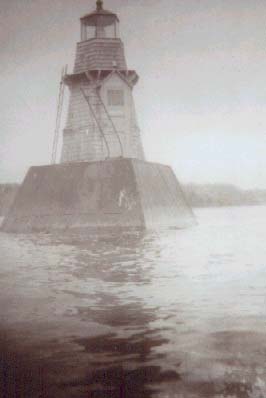
The Chester Rock Light was constructed in 1889 as part of a $15,000 appropriation by Congress that included several other beacons. [2] The exact cost of the structure is unknown. Originally constructed as a 21-foot (6.4 meter) tall wooden hexagonal pyramidal tower, the Chester Rock Light had a black lantern with a 6th order Fresnel lens. [2] [3] First lit on July 1, 1889, with a fixed red light the light was changed to a fixed white light on December 15, 1892. [2] [4] According to the Light List, the light was located on Chester Rock on the west side of the Connecticut River and about .75 miles (1.21 km) north of Deep River, Connecticut. [3]

A Lighthouse Inspection Report from the United States Lighthouse Society from December 1889 states that the hexagonal tower was only accessible by boat. [5] [6] The light's foundation rested upon the river bottom and was a 15-foot (4.6 meter) square crib that was made of yellow pine timbers and sheathed with planks. The crib was filled with stones and protected by riprap. The crib extended up to the high water mark to a frustum of a 15 feet (4.6 m) square pyramid that is reduced to 10 feet (3.0 m) at its top and filled with stone. The sides and top are planked and the corners were covered with boiler plate and angle irons. [7] The original light was a hexagonal beacon lantern made of brass and copper. [8] The oil for the light was stored in boxes in the lower portion of the lantern. [9]

Skeleton tower

According to the Annual Report of the Lighthouse Board, the tower was struck and carried away by a barge being towed by Sachem, a tugboat, on May 10, 1912. [10] The cost of repairs, $602.40, was paid by the owner. [10] During the intervening period, a temporary light post was used in its place. [11] Completed on October 22, 1912, the replacement skeletal tower was a pyramidal steel structure on a concrete base that held its oil internally. The base of the tower was painted white and the daymark was painted black. [12] The skeleton tower lantern was raised to 25 feet (7.6 m) above the water and its light had about 170 candlepower. [12]

It is unknown if a new skeleton tower was installed at a different location than the original tower or if an intervening tower was previously erected in the same location, but the original stone foundation is visible 100 feet (30 m) from the west bank. [13] In 1900, the geographical coordinates were then given as 41.2354 North and 72.2602 West, but this differs from the modern GPS location which is 41.2322 North and 72.2450 West. [3] [14]

Service

Service records for Chester Rock Light show that the light was deactivated for the winter of 1911 and 1914. [15] [16] In 1914, the light was deactivated between January 12–15 and relit between March 14–16. [17] The skeleton tower was modified in 1927, but there are no records about additional work or action with the light. [2] In 1931, an article in The Day noted that the skeleton tower was "in recent years" converted to automatic gas beacons. [18] As of 2014, the skeleton tower is known as Light 35 and features a green flashing light every 4 seconds. [14]

In the 1990s, the Deep River Historical Society of Deep River, Connecticut discovered a photo of the light and began to research its history. [19] Joel Severance, chairman of the harbor commission, wanted to build a 28-foot (8.5 meter) tall replica that would primarily function as a daymark and their plan was endorsed by the Connecticut Department of Transportation in the United States Coast Guard and both the town of Deep River and Middlesex County, Connecticut, but it was expected to be denied by the Connecticut Department of Environmental Protection. [13] [19] In 2000, the plan was rejected by the Connecticut Department of Environmental Protection. [13]

See also

Related Research Articles

<span class="mw-page-title-main">Lighthouse</span> Structure designed to emit light to aid navigation

A lighthouse is a tower, building, or other type of physical structure designed to emit light from a system of lamps and lenses and to serve as a beacon for navigational aid, for maritime pilots at sea or on inland waterways.

<span class="mw-page-title-main">Charlevoix South Pier Light Station</span> Lighthouse in Michigan, United States

The Charlevoix South Pier Light Station is located on Lake Michigan at the entrance to Lake Charlevoix in Charlevoix County in the U.S. state of Michigan at the end of the south pier/breakwater of the channel leading to Round Lake in the city of Charlevoix.

<span class="mw-page-title-main">Toledo Harbor Light</span> Lighthouse in Ohio, US

The Toledo Harbor Lighthouse is a lighthouse in Lake Erie near Toledo, Ohio, in the United States. The light replaced the 1837 lighthouse on Turtle Island at the mouth of the Maumee River. It is an active aid to navigation.

<span class="mw-page-title-main">Unmanned reef lights of the Florida Keys</span> Lighthouses in Florida, United States

The unmanned reef lights of the Florida Keys were navigational aids erected near the Florida Keys between 1921 and 1935. They were intended to mark local hazards and did not need to be visible for as far as the reef lights that were erected near the Keys during the 19th century. By the time the lights in this list were erected, older lighthouses were being automated, and these new lights were designed to be automated from the start. The lights resembled the older reef lights in having a wrought iron skeletal pyramidal structure on a screw-pile foundation. They all originally had lanterns on their peaks, so that they looked like smaller versions of the older reef lights, but had no keeper's quarters.

<span class="mw-page-title-main">Cheboygan Crib Light</span> Lighthouse in Michigan, United States

The Cheboygan Crib Light is a light that marks the west pier head of the mouth of the Cheboygan River into Lake Huron. The pier head, in the center of the municipality of Cheboygan, is located at the north or lake end of Huron Street, and is one of the centerpieces of Cheboygan's Gordon Turner Park.

<span class="mw-page-title-main">Saginaw River Rear Range Light</span> Lighthouse in Michigan, United States

The first Saginaw River lighthouse was constructed from 1839 to 1841, in a period when large quantities of lumber were being harvested and shipped from the heart of Michigan via river and the Great Lakes to the East Coast of the United States via the Erie Canal and Hudson River. This connection to major eastern markets was critical to the development of central Michigan.

<span class="mw-page-title-main">Avery Point Light</span> Lighthouse in Connecticut, United States

Avery Point Light or Avery Point Lighthouse is a lighthouse in Groton, Connecticut, United States, on the Avery Point Campus of the University of Connecticut. Although construction was completed in March 1943, the lighthouse was not lit until May 1944 due to concerns of possible enemy invasion. Its original light consisted of eight 200-watt bulbs that were later replaced by a flashing green light in 1960. It was deactivated on June 25, 1967, when the United States Coast Guard Training Station moved to Governors Island. It is officially listed as the last lighthouse built in the state; the only other claimant is the replica Mystic Seaport Light.

<span class="mw-page-title-main">Bridgeport Harbor Light</span> Lighthouse in Connecticut, United States

The Bridgeport Harbor Light, later the Bridgeport Harbor Lighthouse, was a lighthouse in Bridgeport, Connecticut, United States. It is located on the west side of the Bridgeport Harbor entrance and the north side of Long Island Sound. Originally constructed in 1851 and rebuilt in 1871 with a dwelling, it had a red-fixed light throughout its service life. The builder and first keeper of the light was Abraham A. McNeil who is also credited as improvising the first light for the Bridgeport Harbor in 1844. By 1953, the lighthouse was in poor condition and the United States Coast Guard opted to build a skeleton tower in its place. In the 2014 edition of the Light List Volume 1, the skeleton tower is marked as "Light 13A" with a height of 57 feet (17 m) and a visual marker of a square green dayboard with a green reflective border. The lighthouse was sold and an attempt was made to move it to serve as a monument for Connecticut's maritime history, but it was later decided to scrap the structure. The lighthouse caught fire and was destroyed during the dismantling in 1953.

<span class="mw-page-title-main">Tybee Island Light</span> Lighthouse in Georgia, United States

Tybee Island Light is a lighthouse next to the Savannah River Entrance, on the northeast end of Tybee Island, Georgia. It is one of seven surviving colonial era lighthouse towers, though highly modified in the mid 1800s.

The Leading Point Light was an unusual lighthouse which displayed the rear light to the Brewerton Channel Range. It was eventually superseded by an iron tower on the same foundation.

<span class="mw-page-title-main">White Shoal Light, Michigan</span> Lighthouse in Michigan, United States

The White Shoal Light is a lighthouse located 20 miles (32 km) west of the Mackinac Bridge in Lake Michigan. It is an active aid to navigation. It is also the tallest lighthouse on the Great Lakes.

<span class="mw-page-title-main">East Charity Shoal Light</span> Lighthouse

East Charity Shoal Light is an offshore lighthouse located near the Saint Lawrence River's entrance in northeastern Lake Ontario, due south of the city of Kingston, Ontario and approximately five miles (8 km) southwest of Wolfe Island. It is on the southeast rim of a 3,300-foot-diameter (1,000 m) submerged circular depression known as Charity Shoal Crater that may be the remnants of a meteorite impact.

<span class="mw-page-title-main">Stannard Rock Light</span> Lighthouse in Michigan, United States

The Stannard Rock Light, completed in 1883, is a lighthouse located on a reef that was the most serious hazard to navigation on Lake Superior. The exposed crib of the Stannard Rock Light is rated as one of the top ten engineering feats in the United States. It is 24 miles (39 km) from the nearest land, making it the most distant lighthouse in the United States. It was one of the "stag stations", manned only by men, and had the nickname "The Loneliest Place in the World".

<span class="mw-page-title-main">Fuller Rock Light</span> Lighthouse

The Fuller Rock Light was a lighthouse in Providence, Rhode Island. Destroyed in an explosion, it was replaced by a skeleton tower on the same foundation.

<span class="mw-page-title-main">Creal Reef Light</span> Lighthouse

Creal Reef Light is an active lighthouse located at Creal Reef, a planar reef about 150 kilometres (93 mi) east of Mackay, Queensland, Australia. It guides ships outgoing from Mackay into Hydrographers Passage, a deep water channel east of Mackay. The structure is a stainless steel tower, which also serves as a daymark and carries a racon.

<span class="mw-page-title-main">Peshtigo Reef Light</span> Lighthouse

The Peshtigo Reef Light is a lighthouse in Marinette County, Wisconsin, United States, offshore in lower Green Bay. Constructed in 1936 to replace a lightship, it remains in service.

<span class="mw-page-title-main">Ile Parisienne Light</span> Lighthouse

The Ile Parisienne Light was built in 1911 on the southern tip of remote Ile Parisienne in the middle of Whitefish Bay on Lake Superior on a major shipping lane for ingress/egress to the Soo Locks. It is now a well-known landmark to shipping traffic and pleasure craft. The light is automated and remains seasonally active.

<span class="mw-page-title-main">Racine Harbor Lighthouse and Life Saving Station</span> United States historic place

The Racine Harbor Lighthouse and Life Saving Station is a complex of navigation aids begun by the U.S. government in the 1860s near the harbor of Racine, Wisconsin. It was added to the National Register of Historic Places in 1975.

The Essex Reef Light or Essex Reef Post Light, also known as Hayden's Point Light, was a light in Essex, Connecticut on the Connecticut River. The 21-foot (6.4 m) wooden tower was erected in 1889 and replaced with a skeleton tower by 1919. The skeleton tower was further altered to an automatic gas light a few years prior to 1931. Two of the keepers, Gilbert B. Hayden and Bernie Hayden, relation unknown, were keepers of the light, but their service years are unknown. As of 2014, a 26-foot (7.9 m) skeleton tower serves as an active daymark and it has a green flash every 4 seconds.

<span class="mw-page-title-main">Keweenaw Waterway Lower Entrance Light</span> Lighthouse in Michigan, United States

The Keweenaw Waterway Lower Entrance Light, also known as the Portage Entry Light, is a lighthouse located at the south end of breakwater at mouth of the Portage River in Torch Lake Township. It was listed on the National Register of Historic Places in 2014.

References

  1. Rowlett, Russ. "Lighthouses of the United States: Connecticut". The Lighthouse Directory. University of North Carolina at Chapel Hill . Retrieved 2016-06-24.
  2. 1 2 3 4 Kibesh, Joe (August 1998). "Two Lights on the River". Lighthouse Digest. Retrieved 2 April 2014.
  3. 1 2 3 Light List: Atlantic and Gulf Coasts of the United States (1900). United States Coast Guard. 1900. pp.  60. chester rock light.
  4. Annual Report of the Light-House Board (1893). 1893. Retrieved 2 April 2014.
  5. "Lighthouse Inspection Reports Database Description of Light Station". United States Lighthouse Society. 2006. Retrieved 3 April 2014.
  6. "Lighthouse Inspection Reports Database Description of Light Station - Premises". United States Lighthouse Society. 2006. Retrieved 3 April 2014.
  7. "Lighthouse Inspection Reports Database Description of Light Station - Premises (2)". United States Lighthouse Society. 2006. Retrieved 3 April 2014.
  8. "Lighthouse Inspection Reports Database Description of Light Station - Lantern and fixtures". United States Lighthouse Society. 2006. Retrieved 3 April 2014.
  9. "Lighthouse Inspection Reports Database Description of Light Station - Closets and Storerooms". United States Lighthouse Society. 2006. Retrieved 3 April 2014.
  10. 1 2 Annual Report of the Light-House Board of the United States to the Secretary of the Treasury for the Fiscal Year Ended . U.S. Government Printing Office. 1913. p. 68.
  11. "Latest changes in navigation aids". The Day. 21 May 1912. Retrieved 2 April 2014.
  12. 1 2 "Preparing buoys for icy weather". The Day. 8 November 1912. Retrieved 2 April 2014.
  13. 1 2 3 "State Rejects Plan For Dim Lighthouse". The Day. 28 November 2000. Retrieved 3 April 2014.
  14. 1 2 Light List Volume 1 (2014). United States Coast Guard. 2014.
  15. "more changes in navigation aids". The Day. 27 March 1911. Retrieved 2 April 2014.
  16. "Changes made in navigation aids". The Day. 27 January 1914. Retrieved 2 April 2014.
  17. "Changes made in navigation aids". The Day. 2 April 1913. Retrieved 2 April 2014.
  18. "Big Conn. River Easier Navigated Than Of Old". The Day. 16 November 1931. Retrieved 3 April 2014.
  19. 1 2 "Information Wanted: Chester Rock Lighthouse". Lighthouse Digest. May 1998. Retrieved 2 April 2014.