
A lightvessel, or lightship, is a ship that acts as a lighthouse. They are used in waters that are too deep or otherwise unsuitable for lighthouse construction. Although some records exist of fire beacons being placed on ships in Roman times, the first modern lightvessel was off the Nore sandbank at the mouth of the River Thames in England, placed there by its inventor Robert Hamblin in 1734. The type has become largely obsolete; lighthouses replaced some stations as the construction techniques for lighthouses advanced, while large, automated buoys replaced others.

United States lightship Chesapeake (LS-116/WAL-538/WLV-538) is a museum ship owned by the National Park Service and on a 25-year loan to Baltimore City, and is operated by Historic Ships in Baltimore Museum in Baltimore, Maryland. A National Historic Landmark, she is one of a small number of preserved lightships. Since 1820, several lightships have served at the Chesapeake lightship station and have been called Chesapeake. Lightships were initially lettered in the early 1800s, but then numbered as they were often moved from one light station to another. The name painted on the side of lightships was the short name of the Light Station they were assigned to and was the day time visual aspect of the many Aids to Navigation on board lightships. The United States Coast Guard assigned new hull numbers to all lightships still in service in April 1950. After that date, Light Ship 116 was then known by the new Coast Guard Hull number: WAL-538. In January 1965 the Coast Guard further modified all lightship hull designations from WAL to WLV, so Chesapeake became WLV-538.
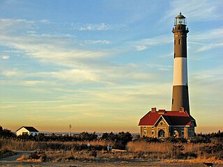
The Fire Island Lighthouse is a visible landmark on the Great South Bay, in southern Suffolk County, New York on the western end of Fire Island, a barrier island off the southern coast of Long Island. The lighthouse is located within Fire Island National Seashore and just to the east of Robert Moses State Park. It is part of the Fire Island Light Station which contains the light, keepers quarters, the lens building containing the original first-order Fresnel lens, and a boat house.

Sheffield Island Light is a historic lighthouse located at the southern end of the Norwalk Islands in Norwalk, Connecticut. It marks the west side of the mouth of the Norwalk River on northern Long Island Sound.
The station named Nantucket or Nantucket Shoals was served by a number of lightvessels that marked the hazardous Nantucket Shoals south of Nantucket Island. The vessels, given numbers as their "name," had the station name painted on their hulls when assigned to the station. Several ships have been assigned to the Nantucket Shoals lightship station and have been called Nantucket. It was common for a lightship to be reassigned and then have the new station name painted on the hull. The Nantucket station was a significant US lightship station for transatlantic voyages. Established in 1854, the station marked the limits of the dangerous Nantucket Shoals. She was the last lightship seen by vessels departing the United States, as well as the first beacon seen on approach. The position was 40 miles (64 km) southeast of Nantucket Island, the farthest lightship in North America, and experienced clockwise rotary tidal currents.

Point Hueneme Lighthouse is a lighthouse on the southeast entrance to the Santa Barbara Channel, in Ventura County, California

Great Captain Island Lighthouse is a lighthouse on Great Captain Island in the western Long Island Sound off the coast of Greenwich, Connecticut, United States. Built in 1829, the first lighthouse, made of stone, was of such poor construction that the walls were severely cracked a decade later. In 1868, a new granite dwelling with attached lantern was completed. The lighthouse is of the same design as lighthouses at Sheffield Island in Norwalk; Morgan Point in Noank; Old Field Point Light and Plum Island in New York; and Block Island North in Rhode Island. In 1890, a fog whistle was added, in 1905 a siren was installed. The lighthouse was deactivated in 1970 when a skeletal tower replaced it. The Town of Greenwich acquired the property in 1973 and had full-time caretakers on the site until the lighthouse became too dilapidated in 2003. A successful restoration effort was completed in 2009 and a non-navigational light was activated in 2012. In 2010, a memorial plaque was installed to "honor the 23 people who lived in Greenwich, or had a connection to the town", who died in the September 11, 2001 attacks. In 1991, the Great Captain Island Light was added to the National Register of Historic Places.
Greens Ledge Light is a historic lighthouse in the western Long Island Sound near Norwalk, Connecticut and Darien, Connecticut. It is one of 33 sparkplug lighthouses still in existence in the United States and remains an active aid to navigation. It sits in ten feet of water on the west end of Greens Ledge, a shallow underwater reef that runs a mile west of Sheffield Island and is roughly a mile south of the entrance to Five Mile River at Rowayton. Completed in 1902 by the Philadelphia Construction Company, the cast-iron structure is approximately 90 feet tall including roughly 15 feet of the submerged caisson. In 1933, more than 30,000 tons of rocks from the excavation of Radio City Music Hall were added to the riprap foundation. The light was added to the National Register of Historic Places as Greens Ledge Lighthouse on May 29, 1990.

New London Ledge Lighthouse is a lighthouse in Groton, Connecticut on the Thames River at the mouth of New London harbor. It is currently owned and maintained by the New London Maritime Society as part of the National Historic Lighthouse Preservation Act program.

Stratford Point Light is a historic lighthouse in Stratford, Connecticut, United States, at the mouth of the Housatonic River. The second tower was one of the first prefabricated cylindrical lighthouses in the country and remains active.
The Hudson–Athens Lighthouse, sometimes called the Hudson City light, is a lighthouse located in the Hudson River in the state of New York in the United States. The light is located between Hudson and Athens, closer to the Hudson side. Constructed in 1874, it marks a sandy ridge known as Middle Ground Flats and also acts as a general aid to navigation of the river. The station is built on a granite caisson with a unique shape designed to protect it from ice floes and river debris. The dwelling is constructed in the Second Empire architectural style, with a mansard roof. It is considered to be virtually a twin of the Stepping Stones Light in Long Island Sound, which was constructed just a few years later.

The United States Coast Guard Cutter Fir was the last lighthouse tender built specifically for the United States Lighthouse Service to resupply lighthouses and lightships, and to service buoys. Fir was built by the Moore Drydock Company in Oakland, California in 1939. On 22 March 1939, the U.S. Lighthouse Tender Fir was launched. She was steam driven with twin screws, 175 feet (53 m) in length, had a beam of 32 feet (9.8 m), drew 11 feet 3 inches (3.43 m) of water, and displaced 885 tons. Fir was fitted with a reinforced bow and stern, and an ice-belt at her water-line for icebreaking. She was built with classic lines and her spaces were lavishly appointed with mahogany, teak, and brass. The crew did intricate ropework throughout the ship. The cost to build Fir was approximately US$390,000. Fir's homeport was Seattle, Washington for all but one of her fifty one years of service when she was temporarily assigned to Long Beach, California when USCGC Walnut was decommissioned on 1 July 1982.

United States lightship Nantucket (LV-112) is a National Historic Landmark lightship that served at the Lightship Nantucket position. She was the last serving lightship and at time of its application as a landmark, one of only two capable of moving under their own power. She served as the lightship for such notable vessels as the liners United States, Queen Mary, and Normandie.
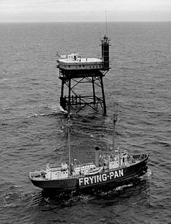
Frying Pan (LV-115) is a lightvessel moored at Pier 66a in the Chelsea neighborhood of Manhattan in New York City. It served at Frying Pan Shoals, off Cape Fear in North Carolina, for over 30 years.

Plum Island Light is located on the western end of Plum Island, which lies east of Orient Point which in turn is at the end of the North Fork of Long Island in the US state of New York. An historic granite lighthouse originally built in 1869 sits at the site, but no longer serves as an active aid to navigation. It was listed on the National Register of Historic Places in 2011. A short distance northwest of the granite lighthouse building is a 14 feet (4.3 m) metal tower that holds the automated light that has served as an aid to navigation since the earlier light was decommissioned in 1978.

The Ship John Shoal Light marks the north side of the ship channel in Delaware Bay on the east coast of the United States, near the Bombay Hook National Wildlife Refuge. Its cast iron superstructure was exhibited at the 1876 Centennial Exposition in Philadelphia, Pennsylvania.
The Cross Ledge Light was a lighthouse on the north side of the ship channel in Delaware Bay off of Cumberland County, New Jersey on the East Coast of the United States, southwest of Egg Island Point. It was replaced by the Elbow of Cross Ledge Light and the Miah Maull Shoal Light in the early 1900s and razed by the United States Coast Guard in 1962.

The Nantucket Lightship or United States Lightship WLV-612 is a lightvessel commissioned in 1950 that became the last lightship decommissioned in United States Coast Guard service.


