Chrystie Street

Last updated
Part of Chrystie Street in Chinatown Manhattan Chinatown.JPG
Part of Chrystie Street in Chinatown

Chrystie Street is a street on Manhattan's Lower East Side and Chinatown, running as a continuation of Second Avenue from Houston Street, for seven blocks south to Canal Street. It is bounded on the east for its entirety by Sara Delano Roosevelt Park, for the creation of which the formerly built-up east side of Chrystie Street (the even numbers) was razed, eliminating among other structures three small synagogues. [1] Originally called First Street, it was renamed for Col. John Chrystie, a veteran of the War of 1812 and a member of the Philolexian Society of Columbia University, and a new First Street was laid out above Houston Street.

Contents

Transportation

Intersection with Canal Street at sunset Chrystie and Canal St Mar 2017 2.jpg
Intersection with Canal Street at sunset

In 1967, the Chrystie Street Connection—a major connecting line of the New York City Subway—opened; it is one of the few connections between lines of the (former) BMT and IND divisions. The B and D trains of the New York City Subway can be reached at Grand Street. [2]

A protected two-way bike lane along Chrystie Street was built in 2016, replacing two older bike lanes that wove between the parking and travel lanes in each direction. It also directly connected the bike lanes between Second Avenue and the Manhattan Bridge. [3]

Notable locations

The second African Burying Ground was located on the west side of First (Chrystie) Street, between Stanton and Rivington Streets, extending to the Bowery, after the African Burial Ground near Collect Pond was declared closed in 1794. In the 1820s St Philip's assumed ownership from the City Council, and when the cemetery was closed in 1853, remains were disinterred and removed to Cypress Hills Cemetery. [4]

On June 28, 1776, on the corner of Chrystie and Grand Streets, Thomas Hickey was hung in front of over 20,000 spectators for having participated in a plot to kill George Washington. [5]

From 1847 through 1854, New York's Temple Emanu-El was located at 56 Chrystie Street, the site now part of the Park. [6]

The settlement movement maintained a Settlement House there, where Lee Strasberg first became involved in the theater. [7] Dorothy Day's Catholic Worker Movement continued this concept with one of their hospitality houses there; Michael Harrington frequented it in 1951/52 shortly after he moved to New York. [8]

Dixon Place, a theater that previously occupied several sites in Lower Manhattan since their foundation in 1986, opened on Chrystie Street in 2009. [9]

The cabaret nightclub The Box Manhattan, sister club to The Box Soho in London, is located in Chrystie Street. [10]

Beginning in the early 1960s, "Chrystie Street" was the name of a column in Dorothy Day's The Catholic Worker newspaper, named for its early location at 225 Chrystie Street. [11]

Chrystie Street appears in "59 Chrystie Street", the first section of the 15th track on the album Paul's Boutique by American hip hop group the Beastie Boys, released on July 25, 1989. The address in the title refers to an early residence of Beastie Boys group members. [12]

In the mid seventies, an unrefurbished loft at 195 Chrystie Street became the shared home of Chris Frantz, Tina Weymouth and David Byrne. This was where they formed and rehearsed the hugely influential rock/pop group Talking Heads.

In the Spider-Man comic book series, Peter Parker's apartment was at 187 Chrystie Street. [13]

In DC Comics' Doorway to Nightmare , Madame Xanadu (Nimue) lived on Chrystie Street, her doorway visible only to those in need of her services. It was sometimes misspelled "Christy," and was variously described as being in Greenwich Village or the East Village. [14]

Related Research Articles

<span class="mw-page-title-main">Ludlow Street (Manhattan)</span> Street in Manhattan, New York

<span class="mw-page-title-main">Delancey Street</span> Street in Manhattan, New York

Delancey Street is one of the main thoroughfares of New York City's Lower East Side in Manhattan, running from the street's western terminus at the Bowery to its eastern end at FDR Drive, connecting to the Williamsburg Bridge and Brooklyn at Clinton Street. It is an eight-lane, median-divided street west of Clinton Street, and a service road for the Williamsburg Bridge east of Clinton Street. West of Bowery, Delancey Street becomes Kenmare Street, which continues as a four-lane, undivided street to Lafayette Street.

<span class="mw-page-title-main">Forsyth Street</span> Street in Manhattan, New York

Forsyth Street runs from Houston Street south to Henry Street in the New York City borough of Manhattan. The street was named in 1817 for Lt. Colonel Benjamin Forsyth.

<span class="mw-page-title-main">Rivington Street</span> Street in Manhattan, New York

Rivington Street is a street in the New York City borough of Manhattan, which runs across the Lower East Side neighborhood, between the Bowery and Pitt Street, with a break between Chrystie and Forsyth for Sara D. Roosevelt Park. Vehicular traffic runs west on this one-way street.

<span class="mw-page-title-main">Second Avenue (Manhattan)</span> North-south avenue in Manhattan, New York

Second Avenue is located on the East Side of the New York City borough of Manhattan extending from Houston Street at its south end to the Harlem River Drive at 128th Street at its north end. A one-way street, vehicular traffic on Second Avenue runs southbound (downtown) only, except for a one-block segment of the avenue in Harlem. South of Houston Street, the roadway continues as Chrystie Street south to Canal Street.

<span class="mw-page-title-main">Chrystie Street Connection</span> New York City Subway track connections

The Chrystie Street Connection is a set of New York City Subway tunnels running the length of Chrystie Street on the Lower East Side of Manhattan. It is one of the few track connections between lines of the former Brooklyn–Manhattan Transit Corporation (BMT) and Independent Subway System (IND) divisions, which together constitute the system's B Division. A major branch of the IND Sixth Avenue Line, it connects the Sixth Avenue Line to the BMT Brighton Line and BMT Fourth Avenue Line via the north side of the Manhattan Bridge and to the BMT Jamaica Line over the Williamsburg Bridge. The project, opened in 1967 and 1968, also includes the Sixth Avenue Line's Grand Street and 57th Street stations, the latter of which is not part of the connection itself.

<span class="mw-page-title-main">Lexington Avenue</span> North-south avenue in Manhattan, New York

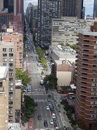
Lexington Avenue, often colloquially abbreviated as "Lex", is an avenue on the East Side of Manhattan in New York City. The avenue carries southbound one-way traffic from East 131st Street to Gramercy Park at East 21st Street. Along its 5.5-mile (8.9-kilometer), 110-block route, Lexington Avenue runs through Harlem, Carnegie Hill, the Upper East Side, Midtown, and Murray Hill to a point of origin that is centered on Gramercy Park. South of Gramercy Park, the axis continues as Irving Place from 20th Street to East 14th Street.

The IND Sixth Avenue Line is a rapid transit line of the B Division of the New York City Subway in the United States. It runs mainly under Sixth Avenue in Manhattan, and continues south to Brooklyn. The B, D, F, and M trains, which use the Sixth Avenue Line through Midtown Manhattan, are colored orange. The B and D trains use the express tracks, while the F, <F> and M trains use the local tracks.

<span class="mw-page-title-main">Ninth Avenue (Manhattan)</span> North-south avenue in Manhattan, New York City

Ninth Avenue, known as Columbus Avenue between West 59th and 110th Streets, is a thoroughfare on the West Side of Manhattan in New York City, United States. Traffic runs downtown (southbound) along the full stretch from Chelsea to the Upper West Side, except for the lowermost three blocks where traffic runs northbound carrying traffic from Greenwich Street.

<span class="mw-page-title-main">Tenth Avenue (Manhattan)</span> North-south avenue in Manhattan, New York

Tenth Avenue, known as Amsterdam Avenue between 59th Street and 193rd Street, is a north-south thoroughfare on the West Side of Manhattan in New York City. It carries uptown (northbound) traffic as far as West 110th Street, after which it continues as a two-way street.

<span class="mw-page-title-main">Madame Xanadu</span> Fictional character in DC Comics

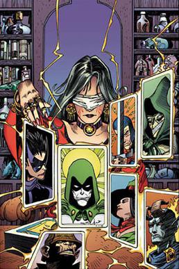
Madame Xanadu is a comic book mystic published by DC Comics. The character is identified with Nimue, the sorceress from Arthurian mythology made popular by Sir Thomas Malory's Le Morte d'Arthur.

<span class="mw-page-title-main">Second Avenue station</span> New York City Subway station in Manhattan

The Second Avenue station is a station on the IND Sixth Avenue Line of the New York City Subway, located at the intersection of Second Avenue and Houston Street on the border between the East Village and the Lower East Side, in Manhattan. It is served by the F train at all times and the <F> train during rush hours in the peak direction.

<span class="mw-page-title-main">Grand Street station (IND Sixth Avenue Line)</span> New York City Subway station in Manhattan

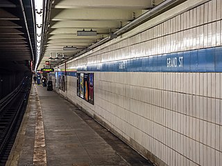
The Grand Street station is an express station on the IND Sixth Avenue Line of the New York City Subway. Located at the intersection of Grand Street and Chrystie Street at the border of Chinatown and the Lower East Side, it is served by the D train at all times and the B train on weekdays.

<span class="mw-page-title-main">Sara D. Roosevelt Park</span> Public park in Manhattan, New York

Sara Delano Roosevelt Park is a 7.8-acre (32,000 m2) park in the Lower East Side of the New York City borough of Manhattan. The park, named after Sara Roosevelt (1854–1941), the mother of President Franklin Delano Roosevelt, stretches north–south along seven blocks between East Houston Street on the Lower East Side and Canal Street in Chinatown, bordered by Chrystie Street on the west and Forsyth Street on the east. The park is operated and maintained by the New York City Department of Parks and Recreation.

<span class="mw-page-title-main">Grand Street (Manhattan)</span> Street in Manhattan, New York

Grand Street is a street in Lower Manhattan, New York City. It runs west/east parallel to and south of Delancey Street, from SoHo through Chinatown, Little Italy, the Bowery, and the Lower East Side. The street's western terminus is Varick Street, and on the east it ends at the service road for the FDR Drive.

<span class="mw-page-title-main">Allen Street</span> Street in Manhattan, New York

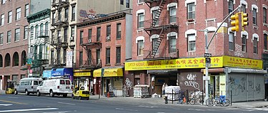
Allen Street is a street in the New York City borough of Manhattan which runs north-south through the Lower Manhattan neighborhood of Chinatown and the Lower East Side. It is continued north of Houston Street as First Avenue. South of Division Street, it is known as Pike Street to its southern terminus at South Street. The northbound and southbound roadways are separated by a meridian mall, which has two bike lanes located outside the meridian mall; each bike lane is unidirectional. The street's namesake was Master Commandant William Henry Allen, the youngest person to command a Navy ship in the War of 1812. He was killed in action at the age of 28. His exploits included the capture of the British ship HMS Macedonian.

<span class="mw-page-title-main">51st Street (Manhattan)</span> West-east street in Manhattan, New York

51st Street is a 1.9-mile (3.1 km) long one-way street traveling east to west across Midtown Manhattan.

<span class="mw-page-title-main">Fourth Avenue (Brooklyn)</span> Avenue in Brooklyn, New York

Fourth Avenue is a major thoroughfare in the New York City borough of Brooklyn. It stretches for 6 miles (9.7 km) south from Times Plaza, which is the triangle intersection created by Atlantic and Flatbush Avenues in Downtown Brooklyn, to Shore Road and the Belt Parkway in Bay Ridge.

<span class="mw-page-title-main">St. Ann Church (Manhattan)</span> Former church in Manhattan, New York

References

  1. "The Synagogues of New York City". Museum of Family History.
  2. "Subway Map" (PDF). Metropolitan Transportation Authority. September 2021. Retrieved September 17, 2021.
  3. Hobbs, Allegra (December 21, 2016). "Chrystie Street Protected Bike Lane Is Complete". DNAinfo New York. Archived from the original on 2017-03-14. Retrieved 2017-03-14.
  4. Jeffreys, D. "About the Garden". M'Finda Kalunga Garden.
  5. Thompson, Slason; Taylor, Hobart C., eds. (1889). America: A Journal for Americans. Vol. 2. p. 235.
  6. Wischnitzer, Rachel (1955). Synagogue Architecture in the United States. Jewish Publication Society of America. p. 48.
  7. "Lee Strasberg". Biography.com .
  8. Isserman, Maurice (February 23, 2015). "Remembering Michael Harrington". Democratic Socialists of America .
  9. Schonberger, Chris (December 2, 2009). "New venue: Dixon Place finally gets its official grand opening". Time Out .
  10. Ryzik, Melena (October 28, 2007). "Is the Box Still Edgy?". The New York Times .
  11. Wilson, Jim (30 September 2021). "Positively Chrystie Street: The Catholic Worker in the Mid-Sixties". Today's American Catholic.
  12. "The Story of Yo". Spin . 1998.
  13. "Peter Parker's apartment". On the Set of New York.
  14. Doorway to Nightmare #1-5; Madame Xanadu (vol. 1) #1