Related Research Articles

Rockland County is the southernmost county on the west side of the Hudson River in the U.S. state of New York. It is part of the New York metropolitan area. The county's population, as of the 2020 United States Census, is 338,329, making it the state's third-most densely populated county outside New York City. The county seat and largest city is New City. Rockland County is accessible via the New York State Thruway, which crosses the Hudson to Westchester at the Tappan Zee Bridge ten exits up from the NYC border, as well as the Palisades Parkway five exits up from the George Washington Bridge. The county's name derives from "rocky land", as the area has been aptly described, largely due to the Hudson River Palisades.
Bardonia is a hamlet and census-designated place in the town of Clarkstown, Rockland County, New York, United States. It is located northeast of Nanuet, northwest of West Nyack, south of New City, and west of Valley Cottage. The population was 4,108 at the 2010 census.

Clarkstown is a town in Rockland County, New York, United States. The town is on the eastern border of the county, located north of the town of Orangetown, east of the town of Ramapo, south of the town of Haverstraw, and west of the Hudson River. As of the 2020 census, the town had a total population of 86,855. The hamlet of New City, the county seat of Rockland County, is also the seat of town government and of the Clarkstown Police Department, the county sheriff's office, and the county correctional facility. New City makes up about 41.47% of the town's population.
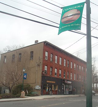
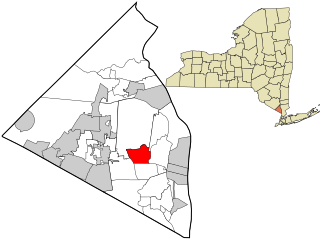
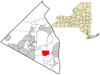
Congers is a suburban hamlet and census-designated place in the town of Clarkstown, Rockland County, New York, United States. It is located north of Valley Cottage, east of New City, across Lake DeForest, south of Haverstraw, and west of the Hudson River. It lies 19 miles (31 km) north of New York City's Bronx boundary. As of the 2010 census, the CDP population was 8,363.

Nanuet is a hamlet and census-designated place in the town of Clarkstown, Rockland County, New York, United States. The third largest hamlet in Clarkstown, it is located north of Pearl River, south of New City, east of Spring Valley, and west of West Nyack. It is located midway between Manhattan and Bear Mountain, 19 miles (31 km) north and south of each respectively; and 2 miles (3 km) north of the New Jersey border. It has one of three Rockland County stations on New Jersey Transit's Pascack Valley Line. The population of Nanuet was 17,882 at the 2010 census.

New City is a hamlet and census-designated place in the town of Clarkstown, Rockland County, New York, United States, part of the New York Metropolitan Area. An affluent suburb of New York City, the hamlet is located 18 miles (29 km) north of the city at its closest point, Riverdale, Bronx. Within Rockland County, New City is located north of Bardonia, northeast of Nanuet, east of New Square and New Hempstead, south of Garnerville and the village of Haverstraw, and west of Congers. New City's population was 35,101 at the 2020 census, making it the 14th most populous CDP/hamlet in the state of New York.

Ramapo is a town in Rockland County, New York, United States. It was originally formed as New Hampstead, in 1791, and became Ramapo in 1828. It shares its name with the Ramapo River. As of the 2020 census, Ramapo had a total population of 148,919, making it the most populous town in New York outside of Long Island. If Ramapo were incorporated as a city, it would be the sixth-largest city in the state of New York.

Valley Cottage is a hamlet and census-designated place in the town of Clarkstown, New York, United States. It is located northeast of West Nyack, northwest of Central Nyack east of Bardonia, south of Congers, northwest of Nyack, and west of Upper Nyack. The population was 9,107 at the 2010 census.
West Nyack is a hamlet and census-designated place in the town of Clarkstown, Rockland County, New York, United States. It is located north of Blauvelt, east of Nanuet, southwest of Valley Cottage, southeast of Bardonia, and west of Central Nyack. It is approximately 18 miles (29 km) north of New York City. The population was 3,439 at the 2010 census.

Rockland Lake State Park is a 1,133-acre (4.59 km2) state park located in the hamlets of Congers and Valley Cottage in the eastern part of the Town of Clarkstown in Rockland County, New York, United States. The park is located on a ridge of Hook Mountain above the west bank of the Hudson River. Included within the park is the 256-acre (1.04 km2) Rockland Lake.
Alliance University ) is a private Christian university affiliated with the Christian and Missionary Alliance and located in New York, New York. Enrolling just over 2,000 students, the school consists of undergraduate programs, graduate professional programs, and the Alliance Theological Seminary. The university has been continuously accredited by the Middle States Commission on Higher Education since 1962, and maintains several specialized professional accreditations pertaining to its programs.

The Gilchrest Road crossing accident was a grade crossing accident that occurred on March 24, 1972, in the town of Clarkstown, New York, between the hamlets of Valley Cottage and Congers, roughly 25 miles (40 km) northwest of New York City. Five students from Valley Cottage were killed, and 44 others were injured.
Central Nyack is a hamlet in the Town of Clarkstown in Rockland County, New York, United States, approximately 20 miles north of New York City; it is north of Blauvelt; east of West Nyack; south of Valley Cottage, and west of the Village of Nyack. As an unincorporated community, governmental functions default to the town level (Clarkstown). The community is located at latitude 41.094 and longitude -73.95. The elevation is 62 feet. The neighborhood is in a mountain-view area, situated just north of Buttermilk Falls County Park and Stephen Rowe Bradley Town Park.

Area codes 845 and 329 are telephone area codes in the North American Numbering Plan (NANP) for the U.S. state of New York. The numbering plan area comprises the mid- and lower Hudson Valley, specifically Orange, Putnam, Rockland, and Ulster counties, and parts of Columbia, Delaware, Dutchess, Greene, and Sullivan counties.

Bedford Central School District is a school district located approximately 50 minutes north of New York City in northern Westchester County, New York, United States. The Bedford Central School District is composed of seven schools - Fox Lane High School, Fox Lane Middle School, Bedford Village Elementary School, Bedford Hills Elementary School, West Patent Elementary School, Pound Ridge Elementary School, and Mt. Kisco Elementary School - serving students from Bedford Hills, Mt. Kisco, Bedford Village, Pound Ridge, and Bedford Corners. Each elementary school serves one town/village/hamlet, except for West Patent, which serves Bedford Hills and Bedford Corners.

Nyack High School is a secondary school serving parts of the Town of Orangetown and Town of Clarkstown, New York, United States. The original Nyack High School building is now part of BOCES. Since 1990, Nyack High School has been located less than a mile north of the old facility, at the corner of Christian Herald Road and Highland Avenue-(U.S. Route 9W).
The New City Condominiums is a working to middle class residential neighborhood near the center of New City, New York, the county seat of Rockland County. The neighborhood takes up the entire street of Heritage Drive, and consists almost entirely of townhouses that were built in the 1970s. It is one of the most urbanized neighborhoods in New City, and is located about 0.8 miles (1.3 km) north of the downtown area.
East Ramapo Central School District is a school district in Ramapo, New York, United States. It is headquartered in the Senator Eugene Levy Dr. Jack R. Anderson Education Center.
Rockland Country Day School was a private coed college-preparatory school that served students in Pre-K through 12th grade. It was located in Congers, New York and was founded in 1959 as an alternative to public education in Rockland County. The school's stated mission was to "[bring] forth the best in every student by knowing and educating each of them as an individual." In 2019 the school was to have celebrated its 60th anniversary, but on August 20, 2019, the school announced it would be closing.

Elijah Reichlin-Melnick is an American politician who served as a member of the New York State Senate for the 38th district, which includes most of Rockland County and parts of Westchester County. He succeeded David Carlucci.
References
- ↑ "Clarkstown Central School District". www.ccsd.edu. Archived from the original on 2016-02-22. Retrieved 2016-03-16.
- ↑ "Clarkstown keeps Congers Elementary closed". lohud.com. Retrieved 2016-03-16.
- ↑ "Welcome to Town of Clarkstown". www.town.clarkstown.ny.us. Archived from the original on 2016-03-05. Retrieved 2016-03-16.
- ↑ "Nyack's Ghost Town: The Lost Village of Rockland Lake". At Home In Nyack. Retrieved 2016-03-16.