Clarkstown, New York

Last updated

Clarkstown, New York
Hook Mountain in Autumn - panoramio.jpg
Hook Mountain in Autumn
Clarkstown, NY Seal.png
Rockland County New York incorporated and unincorporated areas Clarkstown highlighted.svg
Location in Rockland County and the state of New York.
USA New York location map.svg
Red pog.svg
Clarkstown, New York
Location within the state of New York
Coordinates: 41°7′34″N73°58′49″W / 41.12611°N 73.98028°W / 41.12611; -73.98028
CountryUnited States
State New York
County Rockland
EstablishedMarch 18, 1791
Government
  SupervisorGeorge Hoehmann (R)
Area
[1]
  Total47.07 sq mi (121.91 km2)
  Land38.47 sq mi (99.63 km2)
  Water8.60 sq mi (22.28 km2)
Elevation
105 ft (32 m)
Population
 (2020)
  Total86,855
Time zone UTC-5 (Eastern (EST))
  Summer (DST) UTC-4 (EDT)
ZIP code
10956 (New City), 10920 (Congers), 10954 (Nanuet), 10960 (Nyack), 10989 (Valley Cottage), 10994 (West Nyack)
Area code 845
FIPS code 36-15968
GNIS feature ID0978832
Website www.clarkstown.gov

Clarkstown is a town in Rockland County, New York, United States. The town is on the eastern border of the county, located north of the town of Orangetown, east of the town of Ramapo, south of the town of Haverstraw, and west of the Hudson River. As of the 2020 census, the town had a total population of 86,855. [2] The hamlet of New City, the county seat of Rockland County, is also the seat of town government and of the Clarkstown Police Department, the county sheriff's office, and the county correctional facility. New City makes up about 41.47% of the town's population.

Contents

History

The town of Clarkstown was created in 1791 from the town of Haverstraw in Orange County, before Rockland County was formed.

Geography

View of the Town of Clarkstown from High Tor Mountain. Clarkstown NY Landscape.JPG
View of the Town of Clarkstown from High Tor Mountain.

The Hudson River defines the eastern border of the town, which is opposite the town of Mount Pleasant in Westchester County.

According to the United States Census Bureau, the town has a total area of 46.9 square miles (121 km2), of which 38.5 square miles (100 km2) is land and 8.4 square miles (22 km2) (17.87%) is water.

The New York State Thruway (Interstate 87/Interstate 287) intersects the Palisades Interstate Parkway in the town.

Demographics

Historical population
CensusPop.Note
1820 1,808
1830 2,29827.1%
1840 2,53310.2%
1850 3,11122.8%
1860 3,87424.5%
1870 4,1376.8%
1880 4,3785.8%
1890 5,21619.1%
1900 6,30520.9%
1910 7,98026.6%
1920 7,317−8.3%
1930 10,18839.2%
1940 12,25120.2%
1950 15,67427.9%
1960 33,196111.8%
1970 61,65385.7%
1980 77,09125.0%
1990 79,3462.9%
2000 82,0823.4%
2010 84,1872.6%
2020 86,8553.2%
U.S. Decennial Census [3] 2020 [4]

As of the 2010 Census, there were 84,187 people, 29,234 households, and 22,186 families residing in the Town of Clarkstown. The population density was 1,800 per square mile. There were 30,314 housing units at an average density of 646.35 per square mile. There were 29,234 households, out of which 27.9% had children under the age of 18 living with them, 62.1% were married couples living together, 10.4% had a female householder with no husband present, and 24.1% were non-families. 36.2% of all households were made up of individuals, and 31.8% had someone living alone who was 65 years of age of older. The average household size was 2.84 and the average family size was 3.28. The median age was 42.8 years. [5]

As of the census [6] of 2000, there were 82,082 people, 27,697 households, and 21,991 families residing in the town. The population density was 2,129.7 inhabitants per square mile (822.3/km2). There were 28,220 housing units at an average density of 732.2 per square mile (282.7/km2). The racial makeup of the town was 79.97% White, 7.87% African American, 0.13% Native American, 7.90% Asian, 0.10% Pacific Islander, 1.99% from other races, and 2.03% from two or more races. Hispanic or Latino of any race were 6.92% of the population.

There were 27,697 households, out of which 36.9% had children under the age of 18 living with them, 67.4% were married couples living together, 9.1% had a female householder with no husband present, and 20.6% were non-families. 16.9% of all households were made up of individuals, and 6.5% had someone living alone who was 65 years of age or older. The average household size was 2.90 and the average family size was 3.27.

In the town, the population was spread out, with 24.7% under the age of 18, 6.6% from 18 to 24, 28.3% from 25 to 44, 28.1% from 45 to 64, and 12.3% who were 65 years of age or older. The median age was 39 years. For every 100 females, there were 94.3 males. For every 100 females age 18 and over, there were 90.3 males.

According to a 2007 estimate, the median income for a household in the town was $92,121, and the median income for a family was $104,909. [7] Males had a median income of $57,773 versus $40,805 for females. The per capita income for the town was $34,430. About 2.5% of families and 3.8% of the population were below the poverty line, including 4.5% of those under age 18 and 3.4% of those age 65 or over.

As of the 2020 Census, there were 86,855 people residing in the Town of Clarkstown. [8]

Clarkstown is the most densely populated town in Rockland County and is home to New City, which is the county seat. Clarkstown has more business districts in it than any other town in Rockland County, including the Palisades Center, which is among the largest malls in the world.

Elected representation

The Town of Clarkstown has as its chief executive a Town Supervisor. The current Town Supervisor is George Hoehmann. Clarkstown is represented in the United States House of Representatives by Congressman Michael Lawler. It is represented in New York State government by Senator Bill Weber and Assemblyman Kenneth Zebrowski Jr. Clarkstown [9] is divided into four wards as follows:

Public transportation

Clarkstown Mini-Trans
Headquarters10 Maple Avenue
Locale New City, New York
Service areaClarkstown, New York
Service type Bus service, paratransit
Routes5
Fleet10 [10]
(2009 figures)
Daily ridership518 (weekday)
366 (Saturday) [10]
Website www.clarkstown.gov/minitrans

Clarkstown Mini-Trans is the provider of local mass transportation in Clarkstown. It has five bus routes:

Additionally, Transport of Rockland provides local mass transportation. Routes 59, 91, 92, 93, and 97 serve the town. [11]

Commuter transportation is provided by New Jersey Transit's Pascack Valley Line at Nanuet, with service to Hoboken and connecting service to New York Penn Station. Tappan ZEExpress, operated by Transport of Rockland provides bus service from the Palisades Center in West Nyack and the Hudson Link bus in Central Nyack to the Tarrytown train station and the White Plains TransCenter. [12] In addition, Rockland Coaches provides express service to the Port Authority Bus Terminal in New York City from Park-and-Ride and other pickup locations in New City, Bardonia, West Nyack, and Nanuet via Route 49 and 49J, and local service to New York from New City, Valley Cottage, and Upper Nyack on Routes 9A, 9T, and 20. [13]

Education

The town of Clarkstown is served by several school districts. [14] The majority of the town is served by the Clarkstown Central School District, which educates students in New City, Bardonia, Congers, and West Nyack. [15] The village of Upper Nyack as well as the hamlets of Valley Cottage and Central Nyack are served by the Nyack Public Schools, [16] while the Hamlet of Nanuet is served by the Nanuet Union Free School District. [17] A small portion on the western town border is served by the East Ramapo Central School District. [18]

High schools located in the town include Clarkstown South High School in West Nyack, Clarkstown North High School in New City, Nyack Senior High School in Upper Nyack, and Nanuet Senior High School in Nanuet.

Communities and locations in the Town of Clarkstown

Clarkstown Going Green

Clarkstown has taken steps towards "going green" by conducting energy audits, purchasing Energy Star office equipment and using green cleaning products in town facilities. Other steps included:

Climate Action and Sustainability Planning - Training and Outreach

U.S. Supreme Court case

In 1994, Clarkstown was involved in litigation that challenged a town ordinance, that required all waste picked up in the town to be sorted for recyclables at a specific privately operated facility. The case made it to the United States Supreme Court in C&A Carbone, Inc. v. Town of Clarkstown , in which the ordinance was held unconstitutional.

Related Research Articles

<span class="mw-page-title-main">Rockland County, New York</span> County in New York, United States

Rockland County is the second-southernmost county on the west side of the Hudson River in the U.S. state of New York, after Richmond County. It is part of the New York metropolitan area. As of the 2020 U.S. census, the county's population is 338,329, making it the state's third-most densely populated county outside New York City after Nassau and neighboring Westchester Counties. The county seat and largest hamlet is New City. Rockland County is accessible via the New York State Thruway, which crosses the Hudson to Westchester at the Tappan Zee Bridge ten exits up from the NYC border, as well as the Palisades Parkway five exits up from the George Washington Bridge. The county's name derives from "rocky land", as the area has been aptly described, largely due to the Hudson River Palisades. The county is part of the Hudson Valley region of the state.

<span class="mw-page-title-main">Bardonia, New York</span> Hamlet & CDP in New York, United States

Bardonia is a hamlet and census-designated place in the town of Clarkstown, Rockland County, New York, United States. It is located northeast of Nanuet, northwest of West Nyack, south of New City, and west of Valley Cottage. The population was 4,108 at the 2010 census.

<span class="mw-page-title-main">Congers, New York</span> Census-designated place in New York, United States

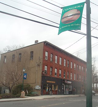
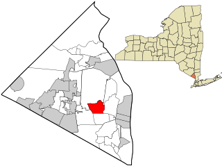
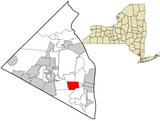
Congers is a suburban hamlet and census-designated place in the town of Clarkstown, Rockland County, New York, United States. It is located north of Valley Cottage, east of New City, across Lake DeForest, south of Haverstraw, and west of the Hudson River. It lies 19 miles (31 km) north of New York City's Bronx boundary. As of the 2020 census, the population was 8,532.

<span class="mw-page-title-main">Nanuet, New York</span> Census-designated place in New York, United States

Nanuet is a hamlet and census-designated place in the town of Clarkstown, Rockland County, New York, United States. The third largest hamlet in Clarkstown, it is located north of Pearl River, south of New City, east of Spring Valley, and west of West Nyack. It is located midway between Manhattan and Bear Mountain, 19 miles (31 km) north and south of each respectively; and 2 miles (3 km) north of the New Jersey border. It has one of three Rockland County stations on New Jersey Transit's Pascack Valley Line. The population of Nanuet was 17,882 at the 2010 census.

<span class="mw-page-title-main">New City, New York</span> Census-designated place in New York, United States

New City is a hamlet and census-designated place in the town of Clarkstown, Rockland County, New York, United States, part of the New York Metropolitan Area. An affluent suburb of New York City, the hamlet is located 18 miles (29 km) north of the city at its closest point, Riverdale, Bronx. Within Rockland County, New City is located north of Bardonia, northeast of Nanuet, east of New Square and New Hempstead, south of Garnerville and the village of Haverstraw, and west of Congers. New City's population was 35,101 at the 2020 census, making it the 14th most populous CDP/hamlet in the state of New York.

<span class="mw-page-title-main">Nyack, New York</span> Village in New York, United States

Nyack is a village located primarily in the town of Orangetown in Rockland County, New York, United States. Incorporated in 1872, it retains a very small western section in Clarkstown. The village had a population of 7,265 as of the 2020 census. It is a suburb of New York City lying approximately 15 miles (24 km) north of the Manhattan boundary near the west bank of the Hudson River, situated north of South Nyack, east of Central Nyack, south of Upper Nyack, and southeast of Valley Cottage.

<span class="mw-page-title-main">Orangetown, New York</span> Town in New York, United States

Orangetown is a town in Rockland County, New York, United States, located in the southeastern part of the county. It is northwest of New York City, north of New Jersey, east of the town of Ramapo, south of the town of Clarkstown, and west of the Hudson River. The population was 48,655 at the 2020 census.

<span class="mw-page-title-main">Ramapo, New York</span> Town in New York, United States

Ramapo is a town in Rockland County, New York, United States. It was originally formed as New Hampstead, in 1791, and became Ramapo in 1828. It shares its name with the Ramapo River. As of the 2020 census, Ramapo had a total population of 148,919, making it the most populous town in New York outside of Long Island. If all towns in New York were cities, Ramapo would be the 12th-largest city in the state of New York.

<span class="mw-page-title-main">Valley Cottage, New York</span> Census-designated place in New York, United States

Valley Cottage is a hamlet and census-designated place in the town of Clarkstown, New York, United States. It is located northeast of West Nyack, northwest of Central Nyack east of Bardonia, south of Congers, northwest of Nyack, and west of Upper Nyack. The population was 9,107 at the 2010 census.

<span class="mw-page-title-main">West Nyack, New York</span> Census-designated place in New York, United States

West Nyack is a hamlet and census-designated place in the town of Clarkstown, Rockland County, New York, United States. It is located north of Blauvelt, east of Nanuet, southwest of Valley Cottage, southeast of Bardonia, and west of Central Nyack. It is approximately 18 miles (29 km) north of New York City. The population was 3,439 at the 2010 census.

<span class="mw-page-title-main">Haverstraw, New York</span> Town in New York, United States

Haverstraw is a town in Rockland County, New York, United States, located north of the Town of Clarkstown and the Town of Ramapo; east of Orange County; south of the Town of Stony Point; and west of the Hudson River. The town runs from the west to the east border of the county in its northern section. The population was 39,087 at the 2020 census.

<span class="mw-page-title-main">Palisades Center</span> Shopping mall in West Nyack, New York

Palisades Center is a shopping mall in West Nyack, New York, which as of December 2022, is the twelfth-largest in the United States by gross leasable space. It has also been one of the nation's most lucrative malls, producing $40 million in annual sales tax and $17 million in property taxes in its first ten years of operation.

<span class="mw-page-title-main">Rockland Lake State Park</span> State park in New York, United States

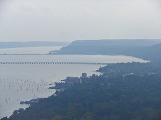
Rockland Lake State Park is a 1,133-acre (4.59 km2) state park located in the hamlets of Congers and Valley Cottage in the eastern part of the Town of Clarkstown in Rockland County, New York, United States. The park is located on a ridge of Hook Mountain above the west bank of the Hudson River. Included within the park is the 256-acre (1.04 km2) Rockland Lake.

Central Nyack is a hamlet in the Town of Clarkstown in Rockland County, New York, United States, approximately 20 miles north of New York City; it is north of Blauvelt; east of West Nyack; south of Valley Cottage, and west of the Village of Nyack. As an unincorporated community, governmental functions default to the town level (Clarkstown). The community is located at latitude 41.094 and longitude -73.95. The elevation is 62 feet. The neighborhood is in a mountain-view area, situated just north of Buttermilk Falls County Park and Stephen Rowe Bradley Town Park.

<span class="mw-page-title-main">New York State Route 59</span> State highway in Rockland County, New York, US

New York State Route 59 (NY 59) is an east–west state highway in southern Rockland County, New York, in the United States. The route extends for 14.08 miles (22.66 km) from NY 17 in Hillburn to U.S. Route 9W (US 9W) in Nyack. In Suffern, it has a concurrency with US 202 for 0.05 miles (0.08 km). NY 59 runs parallel to the New York State Thruway its entire route. The routing of NY 59 became a state highway in 1911 and was signed as NY 59 in the late 1920s.

<span class="mw-page-title-main">New York State Route 304</span> State highway in Rockland County, New York, US

New York State Route 304 (NY 304), also known as "Rockland County Clerk Paul Piperato Memorial Highway", as well as Pearl Street for its first half a mile and Main Street for other parts, is a north–south state highway located in central Rockland County, New York, in the United States. The 10.38-mile (16.70 km) route begins at the New Jersey–New York border in Pearl River and ends at an intersection with U.S. Route 9W (US 9W) in the community of Congers. The route is a main route through Rockland County, intersecting NY 59 and indirectly connecting to the New York State Thruway and the Palisades Interstate Parkway (PIP) in Nanuet. NY 304 has three distinct sections: a freeway that extends from Pearl River to Nanuet, a surface section between Nanuet and New City, and an expressway linking New City to Haverstraw.

<span class="mw-page-title-main">New York State Route 303</span> State highway in Rockland County, New York, US

New York State Route 303 (NY 303) is a north–south state highway in eastern Rockland County, New York, in the United States. It begins at the New Jersey state line in the hamlet of Tappan and runs generally northward for 10.92 miles (17.57 km) to an intersection with U.S. Route 9W (US 9W) in Clarkstown. The route has connections to the Palisades Interstate Parkway and the New York State Thruway, the latter carrying Interstate 87 (I-87) and I-287. NY 303 was assigned as part of the 1930 renumbering of state highways in New York, and only minor realignments have occurred since that time.

<span class="mw-page-title-main">County Route 33 (Rockland County, New York)</span> County road in Rockland County, New York, US

County Route 33 is a 12.7 miles (20.4 km) south–north county route in the central part of Rockland County, New York. Prior to 1970, portions of CR 33 were designated as the old route of New York State Route 304. Today, CR 33 serves as an alternative route for NY 304 from Pearl River to New City where NY 304 ends at US 9W. North of New City, CR 33 serves as an alternative route for the US 9W/US 202 multiplex in northern Rockland County.

The recorded history of Rockland County, New York begins on February 23, 1798, when the county was split off from Orange County, New York and formed as its own administrative division of the state of New York. It is located 6 miles (9.7 km) north-northwest of New York City, and is part of the New York Metropolitan Area. The county seat is the hamlet of New City. The name comes from rocky land, an early description of the area given by settlers. Rockland is New York's southernmost county west of the Hudson River. It is suburban in nature, with a considerable amount of scenic designated parkland. Rockland County does not border any of the New York City boroughs, but is only 9.5 miles (15.3 km) north of Manhattan at the counties' two respective closest points

The Clarkstown Central School District is a K-12 public school district headquartered at the Chestnut Grove Administration Building in New City, in the town of Clarkstown, New York. The district operates fifteen schools serving students in much of the Town of Clarkstown, including the hamlets and villages of New City, Bardonia, Congers, and West Nyack, as well as portions of Nanuet and Valley Cottage. It is the largest school district in Rockland County by population, with a total of 9,196 students.

References

  1. "2016 U.S. Gazetteer Files". United States Census Bureau. Retrieved July 5, 2017.
  2. U.S. Census Bureau, 2020 Report, Clarkstown, Rockland County, New York QuickFacts https://www.census.gov/quickfacts/clarkstowntownrocklandcountynewyork
  3. "Census of Population and Housing". Census.gov. Retrieved June 4, 2015.
  4. U.S. Census Bureau, 2020 Report, Clarkstown, Rockland County, New York QuickFacts https://www.census.gov/quickfacts/clarkstowntownrocklandcountynewyork
  5. "American FactFinder - Results". Wayback.archive-it.org. Archived from the original on May 24, 2017. Retrieved January 31, 2022.
  6. "U.S. Census website". United States Census Bureau . Retrieved January 31, 2008.
  7. "American FactFinder - Results". Archived from the original on February 12, 2020. Retrieved January 31, 2022.
  8. Clarkstown town, Rockland County, New York, Census.gov
  9. "Town Council". Clarkstown.gov. Retrieved January 31, 2022.
  10. 1 2 "NTD Program filing for Clarkstown Mini-Trans, 2009" (PDF). Archived from the original (PDF) on June 7, 2012. Retrieved June 7, 2012.
  11. "County of Rockland, New York :: Transport of Rockland (TOR)". Rocklandgov.com. Retrieved January 31, 2022.
  12. "County of Rockland, New York ::". Rocklandgov.com. Retrieved January 31, 2022.
  13. "Rockland Coaches Commuter Services | Coach USA". Coachusa.com. Retrieved January 31, 2022.
  14. "Clarkstown Schools Information". Town.clarkstown.ny.us. Retrieved January 31, 2022.
  15. "Clarkstown Central School District / District Home". Clarkstown Central School District. Retrieved January 31, 2022.
  16. "Home Page - Nyack Public Schools". Nyackschools.org. Retrieved January 31, 2022.
  17. "Home Page - Nanuet Union Free School District". Nanuetsd.org. Retrieved January 31, 2022.
  18. "East Ramapo CSD / Homepage". Ercsd.org. Retrieved January 31, 2022.
  19. "Solar panels to sprout in former Clarkstown landfill". Lohud.com.
  20. "List of Climate Smart Communities - NYS Dept. Of Environmental Conservation". Archived from the original on April 18, 2019. Retrieved January 2, 2019.
  21. "Hudson Valley and Westchester | Governor's Office of Storm Recovery (GOSR)". Stormrecovery.my.gov.