Pearl River, New York

Last updated

Pearl River
Edward Salyer House, Pearl River, NY.jpg
Edward Salyer House on South Middletown Road in Pearl River.
Rockland County New York incorporated and unincorporated areas Pearl River highlighted.svg
Location in Rockland County and the state of New York
USA New York location map.svg
Red pog.svg
Pearl River
Location within the state of New York
Coordinates: 41°3′32.8″N74°1′12.9″W / 41.059111°N 74.020250°W / 41.059111; -74.020250
CountryUnited States
State New York
County Rockland
Area
[1]
  Total7.19 sq mi (18.63 km2)
  Land6.79 sq mi (17.59 km2)
  Water0.40 sq mi (1.03 km2)
Elevation
240 ft (73 m)
Population
 (2020)
  Total16,567
  Density2,438.83/sq mi (941.59/km2)
Time zone UTC-5 (Eastern (EST))
  Summer (DST) UTC-4 (EDT)
ZIP code
10965
Area code 845
FIPS code 36-56902
GNIS feature ID0960056

Pearl River is a hamlet and census-designated place in the town of Orangetown, Rockland County, New York, United States. It is east of Chestnut Ridge, south of Nanuet, west of Blauvelt, New York, and north of Montvale and Old Tappan, New Jersey. The population was 15,876 at the 2010 census. [2]

Contents

Pearl River is 20 miles (32 km) north of midtown Manhattan and just north of the New Jersey border. It is the first (traveling north) of three New York stops on New Jersey Transit's Pascack Valley Line.

History

Panoramic map of Pearl River from 1924 with list of landmarks and images of several inset Aero-view of Pearl River, New York, 1924. LOC 75694831.jpg
Panoramic map of Pearl River from 1924 with list of landmarks and images of several inset

In 1696, Pearl River was part of a larger piece of land known as the Kakiat Patent that was granted to Daniel Honan and Michael Hawdon. In 1713, the land was split into north and south plots. After the Revolutionary War, the land was further divided and sold. [3] Pearl River was a piece of land made up of woods and swamps originally called Muddy Creek. [4]

In the early 1870s, the town was divided into five different parts: Middletown, Sickletown, Pascack, Muddy Brook, and Naurashaun. [5]

There are conflicting accounts on how Muddy Creek came to be named Pearl River. According to some historians, a town resident named Ves Bogert found small pearls in mussels that thrived in Muddy Brook and, upon hearing this, the wife of John Demarest, the president of the New Jersey and New York Railroad, suggested the name "Pearl River" to him.

Another account is that the name change was made to make the station sound more appealing on railroad schedules. A third account is that Julius E. Braunsdorf wanted to enhance the hamlet's business image by renaming it Pearl River. [3] In any event, there is no body of water near the hamlet called Pearl River; the most significant stream is Muddy Brook.

Braunsdorf, an industrialist and German immigrant, purchased Muddy Creek in 1870. He donated a long strip of land through the center of his property to the New Jersey and New York Railroad to enable it to bring an extension of the line from Hillsdale, New Jersey north to Nanuet.

Braunsdorf was the "Father of Pearl River" and established Aetna Sewing Machine Company to produce his patented home sewing machine in 1872. Later that year the first post office was established in the hamlet and from then on it was known as Pearl River. [4]

Braunsdorf invented and manufactured the carbon-arc light bulb in 1873, six years before Thomas Edison's carbonized filament version. It was installed and used on ships in New York harbor for loading and unloading operations. He also designed generators, one of which powered the first incandescent electric lights, which he also invented, [6] in the nation's capital. [3]

When Braunsdorf designed the street layout, the only existing streets were Pearl Street and Washington Avenue. He drew a wide main street through the middle of town and called it Central Avenue. Parallel to Central Avenue he drew Franklin, after his hero, Benjamin Franklin. To connect Washington, Central, and Franklin he drew three streets and named them William, John and Henry, after his sons.

Braunsdorf built:

In 1894, Talbot C. Dexter moved his Dexter Folder Company to Pearl River. On August 25, 1885, Dexter filed a patent for an automatic folding machine that changed the way newspapers, books, and magazines were folded and assembled. Between 1885 and 1913, Dexter filed many patents, some still in use today. [3]

In 1907, Ernst J. Lederle, former New York City Health Commissioner, established the Lederle Antitoxin Laboratories in Pearl River. In 1930, it became Lederle Laboratories, a division of American Cyanamid. During World War II, Lederle was a major supplier of vaccines and blood plasma to the U.S. armed forces. [7]

In 1931, Gottfried (Fred) Schmidt invented the automatic pinsetter. Brunswick was not interested in an automatic machine at the time. In 1937, AMF acquired the patent rights to this early machine—The “Sch-Bec-Roy”, which stood for Schmidt (inventor), Beckerle (bowling alley proprietor) and McElroy (blueprint designer). [6] [8]

In 1955, Pearl River was the setting for Norby , an NBC situation comedy that aired from January to April of that year and was one of the first regular television series filmed in color. [9] [10] It starred David Wayne as a small-town banker who lived and worked in Pearl River, where the 13 episodes of the series were filmed. [9] [10] [11]

In 2011, CNNMoney.com ranked Pearl River 78th on its annual "100 Best Places to Live" list. [12]

Pearl River Metro-North station Pearl River Station.jpg
Pearl River Metro-North station

Geography

Pearl River is located at 41°3′32.8″N74°1′12.9″W / 41.059111°N 74.020250°W / 41.059111; -74.020250 (41.0591,-74.02025). [13] According to the United States Census Bureau, the CDP has an area of 7.2 square miles (19 km2), of which 6.8 square miles (18 km2) is land and 0.3 square miles (0.78 km2), or 4.87%, is water.

Demographics

Historical population
CensusPop.Note
2020 16,567
U.S. Decennial Census [14]

As of the census [15] of 2000, there were 21,042 people, 5,539 households, and 4,209 families residing in the CDP. The population density was 3,273.2 inhabitants per square mile (1,263.8/km2). There were 5,636 housing units at an average density of 823.8 per square mile (318.1/km2). The racial makeup of the CDP was 72.37% White, 6.39% African American, 0.05% Native American, 7.16% Asian, 0.02% Pacific Islander, 0.57% from other races, and 0.68% from two or more races. Hispanic or Latino of any race were 6.44% of the population.

There were 5,539 households, out of which 33.6% had children under the age of 18 living with them, 64.4% were married couples living together, 8.4% had a female householder with no husband present, and 24.0% were non-families. 20.7% of all households were made up of individuals, and 8.3% had someone living alone who was 65 years of age or older. The average household size was 2.79 and the average family size was 3.26.

In the CDP, the population was spread out, with 25.3% under the age of 18, 6.0% from 18 to 24, 29.3% from 25 to 44, 24.7% from 45 to 64, and 14.6% who were 65 years of age or older. The median age was 39 years. For every 100 females, there were 93.6 males. For every 100 females age 18 and over, there were 91.3 males.

The median income for a household in the CDP was $76,692, and the median income for a family was $91,618. Males had a median income of $58,966 versus $39,452 for females. The per capita income for the CDP was $31,417. About 2.2% of families and 3.4% of the population were below the poverty line, including 3.1% of those under age 18 and 4.7% of those age 65 or over.

Pearl River has a large Irish community and, under the auspices of the Ancient Order of Hibernians, hosts New York State's second-largest Saint Patrick's Day parade, typically on the Sunday after St. Patrick's Day. [16] This large Irish-American population also supports the nation's largest youth Gaelic Athletic Football team. [17]

Commerce

Blue Hill Plaza office tower. New York City is visible in the far distance. Blue Hill Plaza .jpg
Blue Hill Plaza office tower. New York City is visible in the far distance.

Lederle Laboratories (which became Wyeth) was founded in 1907 on a Pearl River farm by Ernst J. Lederle. [7] The site grew to encompass 550 acres (2.2 km2) and 40 buildings, and employ 4,000 workers. After Pfizer acquired Wyeth in 2009, the number of employees at the site was greatly reduced, [18] and most of the campus was sold in the mid-2010s. [7] [19] Streets and a pond on the campus are named after scientists and inventors:

Pearl River is the site of Blue Hill Plaza, an office complex that includes Rockland County's first commercial skyscraper, completed in 1972. [20] [21]

Education

Blue Ribbon United States Department of Education Blue Ribbon School Logo.jpg
Blue Ribbon

The community is served by the Pearl River School District. [22] Pearl River High School serves students in grades 8 through 12. It enrolls about 1,000 students. 96% of the class of 2009 continued on to college, university, or technical school.

Saint Margaret School is a Catholic school serving grades Pre-K through 8.

Sports

The Pearl River High School Pirates have athletic programs such as baseball, basketball, football, swimming, softball, ice hockey, lacrosse, volleyball, field hockey, bowling, soccer, track, wrestling, and chess club. [23]

The 2010 Pearl River High School girls' softball team won the New York State Championship.

Tourism

Braunsdorf Park in downtown Pearl River Pearl River NY Park.JPG
Braunsdorf Park in downtown Pearl River

Historical markers

Landmarks and places of interest

Jacob P. Perry House Jacob P Perry House, Pearl River, NY.jpg
Jacob P. Perry House
Pearl River Post Office Pearl River, NY, post office.jpg
Pearl River Post Office

Notable people

Related Research Articles

<span class="mw-page-title-main">Rockland County, New York</span> County in New York, United States

Rockland County is the second-southernmost county on the west side of the Hudson River in the U.S. state of New York, after Richmond County. It is part of the New York metropolitan area. As of the 2020 U.S. census, the county's population is 338,329, making it the state's third-most densely populated county outside New York City after Nassau and neighboring Westchester Counties. The county seat and largest hamlet is New City. Rockland County is accessible via the New York State Thruway, which crosses the Hudson to Westchester at the Tappan Zee Bridge ten exits up from the NYC border, as well as the Palisades Parkway five exits up from the George Washington Bridge. The county's name derives from "rocky land", as the area has been aptly described, largely due to the Hudson River Palisades.

<span class="mw-page-title-main">Blauvelt, New York</span> Census-designated place in New York, United States

Blauvelt is a hamlet, about 20 miles northwest of New York City. It was a census-designated place, formerly known as Greenbush and then Blauveltville, in the town of Orangetown, Rockland County, New York, United States. It is located north of Tappan, east of Nauraushaun and Pearl River, south of Central Nyack, and west of Orangeburg. As of the 2010 census, the CDP had a population of 5,689.

<span class="mw-page-title-main">Congers, New York</span> Census-designated place in New York, United States

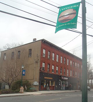
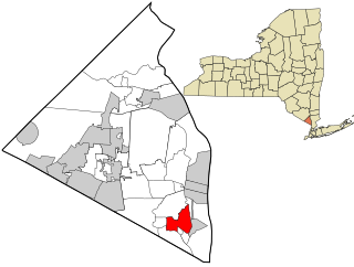
Congers is a suburban hamlet and census-designated place in the town of Clarkstown, Rockland County, New York, United States. It is located north of Valley Cottage, east of New City, across Lake DeForest, south of Haverstraw, and west of the Hudson River. It lies 19 miles (31 km) north of New York City's Bronx boundary. As of the 2020 census, the population was 8,532.

<span class="mw-page-title-main">Nanuet, New York</span> Census-designated place in New York, United States

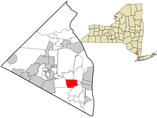
Nanuet is a hamlet and census-designated place in the town of Clarkstown, Rockland County, New York, United States. The third largest hamlet in Clarkstown, it is located north of Pearl River, south of New City, east of Spring Valley, and west of West Nyack. It is located midway between Manhattan and Bear Mountain, 19 miles (31 km) north and south of each respectively; and 2 miles (3 km) north of the New Jersey border. It has one of three Rockland County stations on New Jersey Transit's Pascack Valley Line. The population of Nanuet was 17,882 at the 2010 census.

<span class="mw-page-title-main">Nyack, New York</span> Village in New York, United States

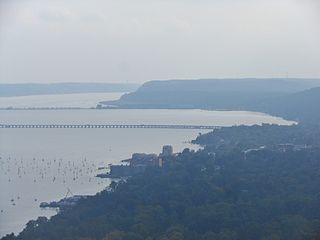
Nyack is a village located primarily in the town of Orangetown in Rockland County, New York, United States. Incorporated in 1872, it retains a very small western section in Clarkstown. The village had a population of 7,265 as of the 2020 census. It is a suburb of New York City lying approximately 15 miles (24 km) north of the Manhattan boundary near the west bank of the Hudson River, situated north of South Nyack, east of Central Nyack, south of Upper Nyack, and southeast of Valley Cottage.

<span class="mw-page-title-main">Orangeburg, New York</span> Census-designated place in New York, United States

Orangeburg is a hamlet and census-designated place, in the town of Orangetown, Rockland County, New York, United States. It is located north of Tappan, south of Blauvelt, east of Pearl River and west of Piermont. The population was 4,568 at the 2010 census.

<span class="mw-page-title-main">Orangetown, New York</span> Town in New York, United States

Orangetown is a town in Rockland County, New York, United States, located in the southeastern part of the county. It is northwest of New York City, north of New Jersey, east of the town of Ramapo, south of the town of Clarkstown, and west of the Hudson River. The population was 48,655 at the 2020 census.

<span class="mw-page-title-main">Piermont, New York</span> Village in New York, United States

Piermont is a village incorporated in 1847 in Rockland County, New York, United States. Piermont is in the town of Orangetown, located north of the hamlet of Palisades, east of Sparkill, and south of Grand View-on-Hudson, on the west bank of the Hudson River. The population was 2,517 at the 2020 census. Woody Allen set The Purple Rose of Cairo, a fictional film within The Purple Rose of Cairo (1984) in Piermont.

<span class="mw-page-title-main">South Nyack, New York</span> Hamlet in New York, United States

South Nyack is a hamlet and census-designated place in the town of Orangetown in Rockland County, New York, United States. It is located north of Grand View-on-Hudson, northeast of Orangeburg, east of Blauvelt State Park, south of Nyack and west of the Hudson River. The hamlet is the western terminus of the Tappan Zee Bridge. Its population was 3,510 at the 2010 census. The hamlet was formerly incorporated as a village from 1878 until 2022.

<span class="mw-page-title-main">Tappan, New York</span> Census-designated place in New York, United States

Tappan is a hamlet and census-designated place in the town of Orangetown, Rockland County, New York. It is located northwest of Alpine, New Jersey, north of Northvale, New Jersey and Rockleigh, New Jersey, northeast of Old Tappan, New Jersey, east/southeast of Nauraushaun and Pearl River, south of Orangeburg, southwest of Sparkill, and west of Palisades; Tappan shares a border with each. The population was 6,673, according to the 2020 census.

<span class="mw-page-title-main">Upper Nyack, New York</span> Village in New York, United States

Upper Nyack is a village incorporated in 1872 in the town of Clarkstown, Rockland County, New York, United States. It is located north of the village of Nyack, east of Valley Cottage, south of Rockland Lake State Park, and west of the Hudson River. The population was 2,063 at the 2010 census.

<span class="mw-page-title-main">Valley Cottage, New York</span> Census-designated place in New York, United States

Valley Cottage is a hamlet and census-designated place in the town of Clarkstown, New York, United States. It is located northeast of West Nyack, northwest of Central Nyack east of Bardonia, south of Congers, northwest of Nyack, and west of Upper Nyack. The population was 9,107 at the 2010 census.

<span class="mw-page-title-main">West Nyack, New York</span> Census-designated place in New York, United States

West Nyack is a hamlet and census-designated place in the town of Clarkstown, Rockland County, New York, United States. It is located north of Blauvelt, east of Nanuet, southwest of Valley Cottage, southeast of Bardonia, and west of Central Nyack. It is approximately 18 miles (29 km) north of New York City. The population was 3,439 at the 2010 census.

<span class="mw-page-title-main">Haverstraw (village), New York</span> Village in New York, United States

Haverstraw is a village incorporated in 1854 in the town of Haverstraw in Rockland County, New York, United States. It is located north of Congers, southeast of West Haverstraw, east of Garnerville, northeast of New City, and west of the Hudson River at its widest point. As of the 2020 census, the population was 12,323.

<span class="mw-page-title-main">Sparkill, New York</span> Census-designated place in New York, United States

Sparkill, formerly known as Tappan Sloat, is a suburban hamlet and census-designated place in the Town of Orangetown, Rockland County, New York, United States located north of Palisades; east of Tappan; south of Piermont and west of the Hudson River. As of the 2010 census, the CDP had a population of 1,565. The hamlet is home to St. Thomas Aquinas College and the Dominican Sisters of Sparkill.

<span class="mw-page-title-main">Pearl River station</span> NJ Transit rail station

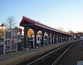
Pearl River station is a railroad station in Pearl River, New York. It serves NJ Transit and Metro-North Railroad trains on the Pascack Valley Line. It is located at 35 South Main Street between West Central Avenue and Jefferson Avenue. Pearl River is the last station in New York, heading from Spring Valley towards Hoboken Terminal.

Sickletown was a hamlet in the town of Orangetown in Rockland County, New York, United States. It was located north of Nauraushaun, east of the state of New Jersey, south of Nanuet, and west of Blauvelt.

Middletown was a hamlet in the Town of Orangetown, Rockland County, New York, United States, located north of Nauraushaun; east of the state of New Jersey; south of Nanuet and west of Blauvelt.

<span class="mw-page-title-main">Michael Salyer Stone House</span> Historic house in New York, United States

The Michael Salyer Stone House is located on Blue Hill Road in Orangetown, New York, United States. It was built in the late 18th century.

The recorded history of Rockland County, New York begins on February 23, 1798, when the county was split off from Orange County, New York and formed as its own administrative division of the state of New York. It is located 6 miles (9.7 km) north-northwest of New York City, and is part of the New York Metropolitan Area. The county seat is the hamlet of New City. The name comes from rocky land, an early description of the area given by settlers. Rockland is New York's southernmost county west of the Hudson River. It is suburban in nature, with a considerable amount of scenic designated parkland. Rockland County does not border any of the New York City boroughs, but is only 9.5 miles (15.3 km) north of Manhattan at the counties' two respective closest points

References

  1. "ArcGIS REST Services Directory". United States Census Bureau. Retrieved September 20, 2022.
  2. "Profile of General Population and Housing Characteristics: 2010 Demographic Profile Data (DP-1): Pearl River CDP, New York". United States Census Bureau . Retrieved February 9, 2012.
  3. 1 2 3 4 "Orangetown Historical Museum & Archives". www.orangetownmuseum.com. Archived from the original on February 28, 2013.
  4. 1 2 Curry, Jack (May 15, 1988). "IF YOU'RE THINKING OF LIVING IN: Pearl River". The New York Times.
  5. Green, Frank Bertangue. MD, The History of Rockland County
  6. 1 2 Peckman, Herbert Pearl River Then and Now. Brief Narrative of one man's love for a community, 125 Anniversary
  7. 1 2 3 Brum, Robert (December 1, 2015) [November 23, 2015]. "Pfizer campus' future sparks memories of past". The Journal News. Retrieved July 23, 2022.
  8. "Old Bowling - Development of the Automatic Pinsetter".
  9. 1 2 Classic TV Archive Norby
  10. 1 2 Brooks, Tim, and Earl Marsh, The Complete Directory to Prime time Network and Cable TV Shows, 1946–Present, Ninth Edition, New York: Ballantine Books, 2007, ISBN   978-0-345-49773-4, p. 996.
  11. "Norby Cast and Details". TV Guide. Retrieved February 16, 2013.
  12. "Money: Best Places to Live 2011". CNN.
  13. "US Gazetteer files: 2010, 2000, and 1990". United States Census Bureau. February 12, 2011. Retrieved April 23, 2011.
  14. "Census of Population and Housing". Census.gov. Retrieved June 4, 2016.
  15. "U.S. Census website". United States Census Bureau . Retrieved January 31, 2008.
  16. "Cardinal Dolan to be in Pearl River for 50th Annual St. Patrick's Parade". Rockland County Times. March 15, 2012.
  17. "Solid As A Rock". Hogan Stand. November 27, 2010.
  18. Palmer, Eric (August 2, 2016). "Pfizer whacks 150 jobs as it closes out vax production at New York site". Fierce Pharma. Retrieved July 23, 2022.
  19. Traster, Tina (January 24, 2022). "Real Estate Veteran Has Plans To Steer Former Pfizer Campus Into A New Era". Rockland County BusinessJournal. Retrieved July 23, 2022.
  20. Blue Hill Plaza.
  21. Daniels, Lee A. (November 27, 1983). "Rockland's New Office Frontier". The New York Times.
  22. Pearl River School District.
  23. Athletics- Home Accessed October 16, 2015.
  24. Kuehnert, Stephanie (November 28, 2016). "Don't Do It 'Cause You Think You Have To: An Interview With Lori Barbero". Rookie Magazine. Retrieved May 17, 2018.
  25. Stapleton, Art. "Inside Brian Gaine's rise from childhood NY Giants fan to Houston Texans general manager", The Record , September 18, 2018. Accessed May 10, 2021. "The man on the poster that hung inside Brian Gaine's Pearl River, N.Y. bedroom embodied everything he wanted the foundation of his own football life to be."
  26. "Biography: Congressman Mike Lawler". Lawler.House.gov. Retrieved April 18, 2024.