Stony Point (CDP), New York

Last updated

Stony Point, New York
Rockland County New York incorporated and unincorporated areas Stony Point (CDP) highlighted.svg
Location in Rockland County and the state of New York.
USA New York location map.svg
Red pog.svg
Stony Point, New York
Location within the state of New York
Coordinates: 41°13′35″N73°59′35″W / 41.22639°N 73.99306°W / 41.22639; -73.99306
Country United States
State New York
County Rockland
Area
[1]
  Total7.19 sq mi (18.62 km2)
  Land5.89 sq mi (15.25 km2)
  Water1.30 sq mi (3.37 km2)
Elevation
118 ft (36 m)
Population
 (2020)
  Total12,126
  Density2,059.79/sq mi (795.26/km2)
Time zone UTC-5 (Eastern (EST))
  Summer (DST) UTC-4 (EDT)
ZIP code
10980
Area code 845
FIPS code 36-71663
GNIS feature ID0966589

Stony Point is a hamlet and census-designated place in the town of Stony Point, Rockland County, New York, United States. It is located north of West Haverstraw, east of Harriman State Park, south of Tomkins Cove, and west of the Hudson River. The population was 12,147 at the 2010 census. [2]

Contents

The community is in the eastern part of the town of Stony Point.

Geography

Stony Point is located at 41°13′34″N73°59′34″W / 41.22611°N 73.99278°W / 41.22611; -73.99278 (41.226361, -73.99293). [3]

According to the United States Census Bureau, the CDP has a total area of 6.8 square miles (18 km2), of which 5.5 square miles (14 km2) is land and 1.3 square miles (3.4 km2), or 18.64%, is water.

Stony Point is home to Camp Bullowa, a 316.7-acre (1.282 km2) Boy Scout camp.

Demographics

Historical population
CensusPop.Note
2020 12,126
U.S. Decennial Census [4]

As of the census [5] of 2000, there were 11,744 people, 3,991 households, and 3,160 families residing in the CDP. The population density was 2,134.8 inhabitants per square mile (824.3/km2). There were 4,074 housing units at an average density of 740.6 per square mile (285.9/km2). The racial makeup of the CDP was 94.25% White, 1.37% Black or African American, 0.14% Native American, 1.39% Asian, 0.03% Pacific Islander, 1.61% from other races, and 1.22% from two or more races. Hispanic or Latino of any race were 7.06% of the population.

There were 3,991 households, out of which 38.1% had children under the age of 18 living with them, 66.1% were married couples living together, 9.6% had a female householder with no husband present, and 20.8% were non-families. 17.4% of all households were made up of individuals, and 8.5% had someone living alone who was 65 years of age or older. The average household size was 2.91 and the average family size was 3.31.

In the CDP, the population was spread out, with 25.9% under the age of 18, 6.6% from 18 to 24, 30.2% from 25 to 44, 25.1% from 45 to 64, and 12.3% who were 65 years of age or older. The median age was 38 years. For every 100 females, there were 98.4 males. For every 100 females age 18 and over, there were 94.0 males.

The median income for a household in the CDP was $71,017, and the median income for a family was $82,124. Males had a median income of $55,014 versus $35,974 for females. The per capita income for the CDP was $27,975. About 1.9% of families and 3.6% of the population were below the poverty line, including 2.7% of those under age 18 and 10.3% of those age 65 or over.

Related Research Articles

<span class="mw-page-title-main">Stony River, Alaska</span> Census-designated place in Alaska, United States

Stony River is a census-designated place (CDP) in Bethel Census Area, Alaska, United States. The population was 54 at the 2010 census, down from 61 in 2000.

<span class="mw-page-title-main">Vamo, Florida</span> Census-designated place in Florida, United States

Vamo is a census-designated place (CDP) in Sarasota County, Florida, United States. The population was 4,727 at the 2010 census. It is part of the Bradenton–Sarasota–Venice Metropolitan Statistical Area.

<span class="mw-page-title-main">Lakes of the Four Seasons, Indiana</span> Census-designated place in Indiana, United States

Lakes of the Four Seasons is a census-designated place (CDP) in Lake and Porter counties in the U.S. state of Indiana. The population was 7,033 at the 2010 census.

<span class="mw-page-title-main">Stony Point, Michigan</span> Census-designated place & unincorporated community in Michigan, United States

Stony Point is an unincorporated community and census-designated place (CDP) in Monroe County in the U.S. state of Michigan. The population was 1,784 at the 2020 census. The CDP is located within Frenchtown Charter Township.

<span class="mw-page-title-main">Escatawpa, Mississippi</span> Census-designated place in Mississippi, United States

Escatawpa is an unincorporated community and census-designated place (CDP) in Jackson County, Mississippi, United States. It is part of the Pascagoula Metropolitan Statistical Area. The population was 3,254 at the 2020 census.

<span class="mw-page-title-main">Noxon, Montana</span> CDP in Montana, United States

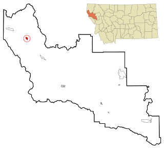
Noxon is a census-designated place (CDP) in Sanders County, Montana, United States. The population of the whole CDP was 255 at the 2020 census.

<span class="mw-page-title-main">Morrisonville, New York</span> Census-designated place in New York, United States

Morrisonville is a hamlet and census-designated place in Clinton County, New York, United States. The population was 1,545 at the 2010 census.

<span class="mw-page-title-main">Crown Heights, New York</span> Census-designated place in New York, United States

Crown Heights is a hamlet and census-designated place (CDP) in Dutchess County, New York, United States. The population was 2,840 at the 2010 census. It is part of the Poughkeepsie–Newburgh–Middletown, NY Metropolitan Statistical Area as well as the larger New York–Newark–Bridgeport, NY-NJ-CT-PA Combined Statistical Area.

<span class="mw-page-title-main">Carmel Hamlet, New York</span> Hamlet and Census-designated place in New York, United States

Carmel Hamlet, commonly known simply as Carmel, is a hamlet and census-designated place (CDP) located in the Town of Carmel in Putnam County, New York, United States. As of the 2010 census, the population was 6,817.

<span class="mw-page-title-main">Mount Ivy, New York</span> Census-designated place in New York, United States

Mount Ivy is a hamlet and census-designated place in the Town of Haverstraw, in Rockland County, New York, United States. It is located north of New City, east of Pomona, south of Thiells, and west of Garnerville. The population was 6,878 at the 2010 census.

<span class="mw-page-title-main">Thiells, New York</span> Census-designated place in New York, United States

Thiells, known as Thiell's Corner in the 1850s, is a hamlet and census-designated place (CDP) in the town of Haverstraw, Rockland County, New York, United States. It is located north of Mount Ivy, east of Pomona, south of Tomkins Cove, and west of Garnerville. The population was 5,240 as of the 2020 census.

<span class="mw-page-title-main">Crompond, New York</span> CDP in New York, United States

Crompond is a hamlet and census-designated place (CDP) located in the town of Yorktown in Westchester County, New York, United States. The population was 2,292 at the 2010 census.

<span class="mw-page-title-main">Heritage Hills, New York</span> Census-designated place in New York, United States

Heritage Hills is a hamlet (CDP) located in the town of Somers in Westchester County, New York, United States. The population was 3,975 at the 2010 census.

<span class="mw-page-title-main">Verplanck, New York</span> CDP in New York, United States

Verplanck is a hamlet and census-designated place (CDP) in the town of Cortlandt, Westchester County, New York, United States. As of the 2010 census it had a population of 1,729. Both the hamlet and Verplanck's Point derive their name from the activities of the Verplanck family, established in New Amsterdam by Abraham Isaacsen Verplanck in the 1630s.

<span class="mw-page-title-main">Stony Prairie, Ohio</span> CDP in Ohio, United States

Stony Prairie is a census-designated place (CDP) in Sandusky County, Ohio, United States. The population was 1,284 at the 2010 census.

Stony Point is a census-designated place (CDP) in Sequoyah County, Oklahoma, United States. It is part of the Fort Smith, Arkansas-Oklahoma Metropolitan Statistical Area. The population was 177 at the 2000 census.

<span class="mw-page-title-main">Aspers, Pennsylvania</span> Census-designated place in Pennsylvania, United States

Aspers is a census-designated place in Adams County, Pennsylvania, United States. As of the 2020 census, it had a population of 486. At the 2000 census it was listed as the Bendersville Station-Aspers CDP.

Northcliffe is a former census-designated place (CDP) in Guadalupe County, Texas, United States. The population was 1,819 at the 2000 census. The area is now part of the city of Schertz and did not have its population recorded separately at the 2010 census. It is part of the San Antonio Metropolitan Statistical Area.

<span class="mw-page-title-main">Stony Point, North Carolina</span> Census-designated place in North Carolina, United States

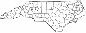
Stony Point is a census-designated place (CDP) in Alexander and Iredell counties in the U.S. state of North Carolina. The population was 1,317 at the 2010 census. It is part of the Hickory–Lenoir–Morganton Metropolitan Statistical Area.

<span class="mw-page-title-main">Jefferson Valley, New York</span> Census-designated place in New York, United States

Jefferson Valley-Yorktown, commonly known as Jefferson Valley, is a census-designated place (CDP) located in the town of Yorktown in Westchester County, New York, United States. The population was 14,142 at the 2010 census. It is a hot spot for local shoppers, due to its Jefferson Valley Mall.

References

  1. "ArcGIS REST Services Directory". United States Census Bureau. Retrieved September 20, 2022.
  2. "Profile of General Population and Housing Characteristics: 2010 Demographic Profile Data (DP-1): Stony Point CDP, New York". United States Census Bureau . Retrieved February 9, 2012.
  3. "US Gazetteer files: 2010, 2000, and 1990". United States Census Bureau. February 12, 2011. Retrieved April 23, 2011.
  4. "Census of Population and Housing". Census.gov. Retrieved June 4, 2016.
  5. "U.S. Census website". United States Census Bureau . Retrieved January 31, 2008.