New Hempstead, New York

Last updated

New Hempstead, New York
Incorporated Village of New Hempstead
Rockland County New York incorporated and unincorporated areas New Hempstead highlighted.svg
Location in Rockland County and the state of New York.
USA New York location map.svg
Red pog.svg
New Hempstead, New York
Location within the state of New York
Coordinates: 41°8′45″N74°2′48″W / 41.14583°N 74.04667°W / 41.14583; -74.04667
Country Flag of the United States.svg  United States
State Flag of New York.svg  New York
County Rockland
Incorporated March 21, 1983
Government
  MayorAvroham Sicker
  Deputy MayorShalom Mintz
  TrusteesJennifer Eisenstein, Adam Reich, and Moshe Schulgasser
Area
[1]
  Total2.85 sq mi (7.39 km2)
  Land2.84 sq mi (7.36 km2)
  Water0.01 sq mi (0.03 km2)
Population
 (2020)
  Total5,463
  Density1,922.24/sq mi (742.25/km2)
Time zone UTC-5 (Eastern (EST))
  Summer (DST) UTC-4 (EDT)
ZIP code
10977
Area code 845
FIPS code 36-50353
Website www.newhempstead.org

New Hempstead is a village in the town of Ramapo, Rockland County, New York, United States. It is located north of New Square, east of Wesley Hills, south of Pomona, and west of New City. The population was 5,132 at the 2010 census. [2] Residents utilize the Spring Valley and New City post offices.

Contents

History

New Hempstead was incorporated on March 21, 1983. [3] Joseph Berger of the New York Times said in a 1997 article that New Hempstead was one of several villages formed in Ramapo by non-Jews and more secular Jews "to preserve the sparse Better Homes and Garden [ sic ] ambiance that attracted them to Rockland County." [4]

Geography

New Hempstead is located at 41°8′45″N74°2′48″W / 41.14583°N 74.04667°W / 41.14583; -74.04667 (41.145945, -74.046641). [5]

According to the United States Census Bureau, the village has a total area of 2.8 square miles (7.3 km2), of which 2.8 square miles (7.3 km2) is land and .35% is water.

New Hempstead is located roughly 14 miles (23 km) north of the Tappan Zee Bridge and roughly 30 miles (48 km) northeast of New York City. [3]

Demographics

Historical population
CensusPop.Note
1990 4,200
2000 4,76713.5%
2010 5,1327.7%
2020 5,4636.4%
U.S. Decennial Census [6]

As of the census [7] of 2000, there were 4,767 people, 1,282 households, and 1,160 families residing in the village. The population density was 1,678.8 inhabitants per square mile (648.2/km2). There were 1,300 housing units at an average density of 457.8 per square mile (176.8/km2). The racial makeup of the village was 69.96% white, 17.54% African American, .17% Native American, 7.26% Asian, .08% Pacific Islander, 3.06% from other races, and 1.93% from two or more races. Hispanic or Latino of any race were 9.04% of the population.

There were 1,282 households, out of which 48.6% had children under the age of 18 living with them, 81% were married couples living together, 6.6% had a female householder with no husband present, and 9.5% were non-families. 7.4% of all households were made up of individuals, and 2.9% had someone living alone who was 65 years of age or older. The average household size was 3.69 and the average family size was 3.88.

In the village, the population was spread out, with 35.7% under the age of 18, 6.2% from 18 to 24, 26.9% from 25 to 44, 23.2% from 45 to 64, and 8.0% who were 65 years of age or older. The median age was 34 years. For every 100 females, there were 99.9 males. For every 100 females age 18 and over, there were 99 males.

The median income for a household in the village was $95,472, and the median income for a family was $100,127. Males had a median income of $64,013 versus $44,028 for females. The per capita income for the village was $32,917. About 1.2% of families and 4.2% of the population were below the poverty line, including 4.3% of those under age 18 and 1.8% of those age 65 or over.

Government

As of July 2021, the mayor of New Hempstead is Abe Sicker, the deputy mayor is Shalom Mintz, and the trustees are Jennifer Eisenstein, Adam Reich, and Moshe Schulgasser. [8] The village is located within the East Ramapo School District. [9]

Landmarks and places of interest

See also

Related Research Articles

<span class="mw-page-title-main">Airmont, New York</span> Village in New York, United States

Airmont is a village in the town of Ramapo, Rockland County, New York, United States, located north of the state of New Jersey, east of Suffern, south of Montebello, and west of Chestnut Ridge. The population was 10,166 at the 2020 census.

<span class="mw-page-title-main">Chestnut Ridge, New York</span> Village in New York, United States

Chestnut Ridge is a village in the town of Ramapo, Rockland County, New York, United States, located north of the state of New Jersey, east of Airmont, south of Spring Valley, and west of Nanuet. The population was 10,505 at the 2020 census.

<span class="mw-page-title-main">Hillcrest, Rockland County, New York</span> Census-designated place in New York, United States

Hillcrest is a hamlet incorporated in 1893 and census-designated place, in the town of Ramapo, Rockland County, New York, United States. It is located north of Spring Valley, east of Viola, south of New Square and New Hempstead, and west of New City. The population was 8,164 at the 2020 census.

<span class="mw-page-title-main">Kaser, New York</span> Village in New York, United States

Kaser is a village in the town of Ramapo, Rockland County, New York, United States. The village is completely surrounded by the hamlet of Monsey. As of the 2020 United States census, the village population was 5,491.

<span class="mw-page-title-main">Mount Ivy, New York</span> Census-designated place in New York, United States

Mount Ivy is a hamlet and census-designated place in the Town of Haverstraw, in Rockland County, New York, United States. It is located north of New City, east of Pomona, south of Thiells, and west of Garnerville. The population was 6,878 at the 2010 census.

<span class="mw-page-title-main">New Square, New York</span> Village in New York, United States

New Square is an all-Hasidic village in the town of Ramapo, Rockland County, New York, United States. It is located north of Hillcrest, east of Viola, south of New Hempstead, and west of New City. As of the 2020 United States census, it had a population of 9,679. Its inhabitants are predominantly members of the Skverer Hasidic movement who seek to maintain a Hasidic lifestyle disconnected from the secular world. It is the poorest town in New York, and the eighth poorest in the United States. It also has the highest poverty rate, at 64.4%.

<span class="mw-page-title-main">Pomona, New York</span> Village in New York, United States

Pomona is a village partly in the town of Ramapo and partly in the town of Haverstraw in Rockland County, New York, United States. It is located north of New Hempstead, east of Harriman State Park, north of Monsey and west of Mount Ivy. According to the 2020 Census, the population was 3,824, a 23 percent increase from the 2010 figure of 3,103.

<span class="mw-page-title-main">Ramapo, New York</span> Town in New York, United States

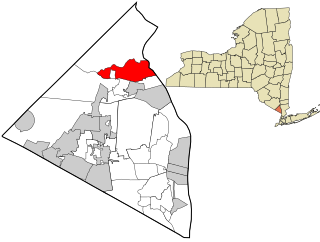
Ramapo is a town in Rockland County, New York, United States. It was originally formed as New Hampstead, in 1791, and became Ramapo in 1828. It shares its name with the Ramapo River. As of the 2020 census, Ramapo had a total population of 148,919, making it the most populous town in New York outside of Long Island. If all towns in New York were cities, Ramapo would be the 12th-largest city in the state of New York.

<span class="mw-page-title-main">Sloatsburg, New York</span> Village in Ramapo, New York, US

Sloatsburg is a village in the town of Ramapo in Rockland County, New York, United States. Located east of Orange County, it is at the southern entrance to Harriman State Park. The population was 3,036 at the 2020 census. The village is named after Stephen Sloat, an early European landowner.

<span class="mw-page-title-main">Spring Valley, New York</span> Village in Rockland County, New York, United States

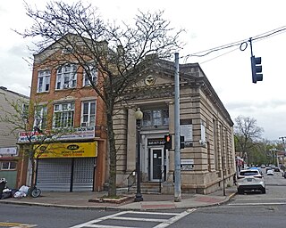
Spring Valley is a village in the town of Ramapo and Clarkstown in Rockland County, New York, United States. It is located north of Chestnut Ridge, east of Airmont and Monsey, south of Hillcrest, and west of Nanuet. The population was 33,066 at the 2020 census, making it the second most populous community in both Clarkstown and Rockland County, after New City.

<span class="mw-page-title-main">Thiells, New York</span> Census-designated place in New York, United States

Thiells, known as Thiell's Corner in the 1850s, is a hamlet and census-designated place (CDP) in the town of Haverstraw, Rockland County, New York, United States. It is located north of Mount Ivy, east of Pomona, south of Tomkins Cove, and west of Garnerville. The population was 5,240 as of the 2020 census.

<span class="mw-page-title-main">Viola, New York</span> Census-designated place in New York, United States

Viola is a hamlet and census-designated place in the town of Ramapo, Rockland County, New York, United States. It is located north of Airmont, east of Montebello, south of Wesley Hills, and west of Hillcrest. The population was 6,868 at the 2010 census.

<span class="mw-page-title-main">Wesley Hills, New York</span> Village in New York, United States

Wesley Hills is a village in the town of Ramapo, Rockland County, New York, United States. It is located north of Viola, east of Harriman State Park, south of Pomona, and west of New Hempstead. The population was 5,628 at the 2010 census.

<span class="mw-page-title-main">West Haverstraw, New York</span> Village in New York, United States

West Haverstraw is a village incorporated in 1883 in the town of Haverstraw, Rockland County, New York, United States. It is located northwest of Haverstraw village, east of Thiells, south of the hamlet of Stony Point, and west of the Hudson River. The population was 10,165 at the 2010 census. The majority of the hamlet of Garnerville is contained in the village of West Haverstraw.

<span class="mw-page-title-main">Clintondale, New York</span> CDP in New York, United States

Clintondale is a hamlet in Ulster County, New York, United States. The population was 1,938 at the 2020 census.

The village of Moravia in Cayuga County, New York, United States is a community with population of about 1,200. The village of Moravia is in the southern part of the town of Moravia and is south of Auburn.

<span class="mw-page-title-main">Haverstraw (village), New York</span> Village in New York, United States

Haverstraw is a village incorporated in 1854 in the town of Haverstraw in Rockland County, New York, United States. It is located north of Congers, southeast of West Haverstraw, east of Garnerville, northeast of New City, and west of the Hudson River at its widest point. As of the 2020 census, the population was 12,323.

<span class="mw-page-title-main">Haverstraw, New York</span> Town in New York, United States

Haverstraw is a town in Rockland County, New York, United States, located north of the Town of Clarkstown and the Town of Ramapo; east of Orange County; south of the Town of Stony Point; and west of the Hudson River. The town runs from the west to the east border of the county in its northern section. The population was 39,087 at the 2020 census.

<span class="mw-page-title-main">Stony Point (CDP), New York</span> Census-designated place in New York, United States

Stony Point is a hamlet and census-designated place in the town of Stony Point, Rockland County, New York, United States. It is located north of West Haverstraw, east of Harriman State Park, south of Tomkins Cove, and west of the Hudson River. The population was 12,147 at the 2010 census.

<span class="mw-page-title-main">Monroe, New York</span> Town in Orange County, New York, US

Monroe is a town in Orange County, New York, United States. The population was 21,387 at the 2020 census, compared to 39,912 at the 2010 census; the significant fall in census population was due to the secession of the town of Palm Tree in 2019. The town is named after President James Monroe.

References

  1. "ArcGIS REST Services Directory". United States Census Bureau. Retrieved September 20, 2022.
  2. "Profile of General Population and Housing Characteristics: 2010 Demographic Profile Data (DP-1): New Hempstead village, New York". United States Census Bureau . Retrieved February 3, 2012.
  3. 1 2 "Village of New Hempstead" . Retrieved July 8, 2021.
  4. Berger, Joseph. "Growing Pains for a Rural Hasidic Enclave." The New York Times . January 13, 1997.
  5. "US Gazetteer files: 2010, 2000, and 1990". United States Census Bureau. February 12, 2011. Retrieved April 23, 2011.
  6. "Census of Population and Housing". Census.gov. Retrieved June 4, 2015.
  7. "U.S. Census website". United States Census Bureau . Retrieved January 31, 2008.
  8. "Board of Trustees – Village of New Hempstead" . Retrieved July 8, 2021.
  9. "Useful Links – Village of New Hempstead" . Retrieved July 8, 2021.