Hillcrest, Rockland County, New York

Last updated

Hillcrest, New York
Rockland County New York incorporated and unincorporated areas Hillcrest highlighted.svg
Location in Rockland County and the state of New York.
USA New York location map.svg
Red pog.svg
Hillcrest, New York
Location within the state of New York
Coordinates: 41°7′47″N74°2′8″W / 41.12972°N 74.03556°W / 41.12972; -74.03556
Country United States
State New York
County Rockland
Area
[1]
  Total1.30 sq mi (3.38 km2)
  Land1.30 sq mi (3.38 km2)
  Water0.00 sq mi (0.00 km2)
Elevation
512 ft (156 m)
Population
 (2020)
  Total8,164
  Density6,255.94/sq mi (2,415.46/km2)
Time zone UTC-5 (Eastern (EST))
  Summer (DST) UTC-4 (EDT)
FIPS code 36-34693
GNIS feature ID0952813

Hillcrest is a hamlet incorporated in 1893 and census-designated place, in the town of Ramapo, Rockland County, New York, United States. It is located north of Spring Valley, east of Viola, south of New Square and New Hempstead, and west of New City. The population was 8,164 at the 2020 census. [2]

Contents

It is a bedroom suburb of New York City, as many residents commute to employment in Manhattan (and, to a lesser extent, northern New Jersey) by bus (Red and Tan Lines), train (Metro-North Railroad) or automobile.[ citation needed ] It is primarily served by the Spring Valley post office.

History

In the early 1900s, Hillcrest became a summer retreat for working-class families from New York City; the families could access Hillcrest by train from New Jersey (after ferrying across to the western shore of the Hudson). In 1955, the Tappan Zee Bridge opened (connecting Tarrytown in Westchester County with Nyack in Rockland County), increasing traffic into the community and making access to New York City easier for the local population. Along with many other communities in the lower Hudson Valley, Hillcrest became a destination for White Flight from New York City in the 1950s through 1970s. Craig H. Long, the Town of Ramapo historian, said that many secular Jews were part of the first wave of settlers into Hillcrest after the opening of the Tappan Zee. In the 1960s, Hillcrest attracted Jews from the boroughs of Brooklyn and The Bronx in New York City; the Jewish people going to Hillcrest desired inexpensive starter homes, a short commute and a suburban atmosphere.

In the 1990s, the community attracted immigrants from Asia and the Caribbean, as well as new residents from Brooklyn and The Bronx; the newcomers moved to the community for the same reasons as the Jews did in previous decades. In the 1990s, the community lost a greater percentage of white people than any other place in New York. From 1980 to 2001, the community's demographics changed from almost completely white to around one-fifth white. According to the 2000 Census, Hillcrest is a majority African-American community. David W. Chen of The New York Times said that "perhaps one of the reasons Hillcrest has managed to evolve so significantly yet anonymously" is the community's hamlet status; he added that "even within Ramapo, Hillcrest is often overlooked." Chen reported that many real estate agents and residents said that no one factor caused or contributed to the ethnic change. Many families moved because their children became adults and they wanted lower property tax rates or because they retired and moved to warmer climates. The significant exodus of Jews from Hillcrest in the 1990s resulted in the closure of many local businesses that had operated for more than thirty years, including kosher butcher shops, kosher delis and bakeries in Hillcrest and nearby communities such as Spring Valley and New City. [3]

Geography

Hillcrest is located at 41°7′47″N74°2′8″W / 41.12972°N 74.03556°W / 41.12972; -74.03556 (41.129645, -74.035527). [4]

According to the United States Census Bureau, the CDP has a total area of 1.3 square miles (3.4 km2), all land.

Hillcrest is located on the eastern edge of the town of Ramapo, approximately midway between the town of Haverstraw to the north and the New Jersey border (Bergen County) to the south. Hillcrest is bordered on the north by the villages of New Hempstead and New Square, on the south by the village of Spring Valley and by an unincorporated area of the town of Ramapo, on the east by an unincorporated area of the town of Clarkstown, and on the west by the villages of New Hempstead and Viola.

Demographics

Historical population
CensusPop.Note
2010 7,558
2020 8,1648.0%
U.S. Decennial Census [5]
2010 [6] 2020 [7]

2020 census

Hillcrest CDP, New York – Racial and ethnic composition
Note: the US Census treats Hispanic/Latino as an ethnic category. This table excludes Latinos from the racial categories and assigns them to a separate category. Hispanics/Latinos may be of any race.
Race / Ethnicity (NH = Non-Hispanic)Pop 2010 [6] Pop 2020 [7] % 2010% 2020
White alone (NH)94388112.48%10.79%
Black or African American alone (NH)4,0653,07053.78%37.60%
Native American or Alaska Native alone (NH)14470.19%0.58%
Asian alone (NH)81759910.81%7.34%
Pacific Islander alone (NH)400.05%0.00%
Some Other Race alone (NH)50750.66%0.92%
Mixed Race/Multi-Racial (NH)1541312.04%1.60%
Hispanic or Latino (any race)1,5113,36119.99%41.17%
Total7,5588,164100.00%100.00%

Note: the US Census treats Hispanic/Latino as an ethnic category. This table excludes Latinos from the racial categories and assigns them to a separate category. Hispanics/Latinos can be of any race.

2000 Census

As of the census [8] of 2000, there were 7,106 people, 1,979 households, and 1,593 families residing in the CDP. The population density was 5,505.8 inhabitants per square mile (2,125.8/km2). There were 2,036 housing units at an average density of 1,577.5 per square mile (609.1/km2). This population density is reflected in the Town of Ramapo's land use plan, which designates most of Hillcrest as medium-high density residential (3 to 10 dwelling units per acre), with a very small portion, located at the intersection of New York Route 45 and Eckerson Road (County Route 74), designated as neighborhood businesses.

The racial makeup of the CDP was 25.58% White, 51.11% African American, 0.32% Native American, 14.69% Asian, 0.07% Pacific Islander, 4.02% from other races, and 4.19% from two or more races. Hispanic or Latino of any race were 11.48% of the population.

There were 1,979 households, out of which 42.3% had children under the age of 18 living with them, 63.1% were married couples living together, 12.4% had a female householder with no husband present, and 19.5% were non-families. 16.5% of all households were made up of individuals, and 8.7% had someone living alone who was 65 years of age or older. The average household size was 3.49 and the average family size was 3.89.

In the CDP, the population was spread out, with 26.7% under the age of 18, 9.3% from 18 to 24, 26.5% from 25 to 44, 24.8% from 45 to 64, and 12.6% who were 65 years of age or older. The median age was 38 years. For every 100 females, there were 95.9 males. For every 100 females age 18 and over, there were 91.1 males.

The median income for a household in the CDP was $68,889, and the median income for a family was $76,960. Males had a median income of $38,451 versus $35,408 for females. The per capita income for the CDP was $21,993. About 7.6% of families and 8.1% of the population were below the poverty line, including 10.1% of those under age 18 and 15.8% of those age 65 or over.

Education

The community is within the East Ramapo Central School District.

Related Research Articles

<span class="mw-page-title-main">Baldwin Harbor, New York</span> Hamlet and former census-designated place in New York, United States

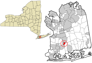
Baldwin Harbor is a hamlet and former census-designated place (CDP) in the Town of Hempstead, in Nassau County, on Long Island, in New York, United States. It was created concomitant with the 1990 United States Census from the southernmost portions of the neighboring hamlet of Baldwin. As of the 2010 census, it had a population of 8,102.

<span class="mw-page-title-main">Bellerose Terrace, New York</span> Hamlet and census-designated place in New York, United States

Bellerose Terrace is a hamlet and census-designated place (CDP) in the Town of Hempstead in Nassau County, on Long Island, in New York, United States. The population was 2,329 at the 2020 census.

<span class="mw-page-title-main">Inwood, New York</span> Hamlet and census-designated place in New York, United States

Inwood is a hamlet and census-designated place (CDP) in Nassau County, on Long Island, in New York, United States. The population was 11,340 at the time of the 2020 census. It is considered part of Long Island's Five Towns area and is located within the Town of Hempstead.

<span class="mw-page-title-main">Lakeview, New York</span> Hamlet and Census-designated place in New York, United States

Lakeview is a hamlet and census-designated place (CDP) in the Town of Hempstead in Nassau County, on Long Island, in New York, United States. The population was 6,077 at the 2020 census.

<span class="mw-page-title-main">New Cassel, New York</span> Hamlet and census-designated place in New York, United States

New Cassel is a hamlet and census-designated place (CDP) in the Town of North Hempstead in Nassau County, on Long Island, in New York, United States. The population was 14,059 at the 2010 census, representing a net gain of 761 over the 2000 census.

<span class="mw-page-title-main">South Hempstead, New York</span> Hamlet and census-designated place in New York, United States

South Hempstead is a hamlet and census-designated place (CDP) in the Town of Hempstead in Nassau County, on Long Island, in New York, United States. The population was 3,406 at the time of the 2020 census.

<span class="mw-page-title-main">Uniondale, New York</span> Hamlet and census-designated place in New York, United States

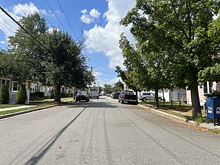
Uniondale is a hamlet and census-designated place in Nassau County, New York, on Long Island, in the town of Hempstead. The population was 32,473 at the time of the 2020 census. Uniondale is home to Hofstra University's north campus, as well as a portion of its southern campus.

<span class="mw-page-title-main">Airmont, New York</span> Village in New York, United States

Airmont is a village in the town of Ramapo, Rockland County, New York, United States, located north of the state of New Jersey, east of Suffern, south of Montebello, and west of Chestnut Ridge. The population was 10,166 at the 2020 census.

<span class="mw-page-title-main">Chestnut Ridge, New York</span> Village in New York, United States

Chestnut Ridge is a village in the town of Ramapo, Rockland County, New York, United States, located north of the state of New Jersey, east of Airmont, south of Spring Valley, and west of Nanuet. The population was 10,505 at the 2020 census.

<span class="mw-page-title-main">Kaser, New York</span> Village in New York, United States

Kaser is a village in the town of Ramapo, Rockland County, New York, United States. The village is completely surrounded by the hamlet of Monsey. As of the 2020 United States census, the village population was 5,491.

<span class="mw-page-title-main">Monsey, New York</span> CDP in New York, United States

Monsey is a hamlet and census-designated place in the town of Ramapo, Rockland County, New York, United States, located north of Airmont, east of Viola, south of New Hempstead, and west of Spring Valley. The village of Kaser is surrounded by the hamlet of Monsey. The 2020 census listed the population at 26,954; a 46% increase since the 2010 census.

<span class="mw-page-title-main">Mount Ivy, New York</span> Census-designated place in New York, United States

Mount Ivy is a hamlet and census-designated place in the Town of Haverstraw, in Rockland County, New York, United States. It is located north of New City, east of Pomona, south of Thiells, and west of Garnerville. The population was 6,878 at the 2010 census.

<span class="mw-page-title-main">New Hempstead, New York</span> Village in New York, United States

New Hempstead is a village in the town of Ramapo, Rockland County, New York, United States. It is located north of New Square, east of Wesley Hills, south of Pomona, and west of New City. The population was 5,132 at the 2010 census. Residents utilize the Spring Valley and New City post offices.

<span class="mw-page-title-main">New Square, New York</span> Village in New York, United States

New Square is an all-Hasidic village in the town of Ramapo, Rockland County, New York, United States. It is located north of Hillcrest, east of Viola, south of New Hempstead, and west of New City. As of the 2020 United States census, it had a population of 9,679. Its inhabitants are predominantly members of the Skverer Hasidic movement who seek to maintain a Hasidic lifestyle disconnected from the secular world. It is the poorest town in New York, and the eighth poorest in the United States. It also has the highest poverty rate, at 64.4%.

<span class="mw-page-title-main">Pomona, New York</span> Village in New York, United States

Pomona is a village partly in the town of Ramapo and partly in the town of Haverstraw in Rockland County, New York, United States. It is located north of New Hempstead, east of Harriman State Park, north of Monsey and west of Mount Ivy. According to the 2020 Census, the population was 3,824, a 23 percent increase from the 2010 figure of 3,103.

<span class="mw-page-title-main">Ramapo, New York</span> Town in New York, United States

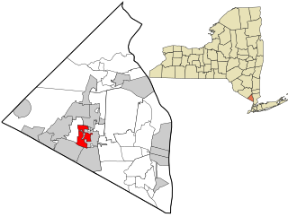
Ramapo is a town in Rockland County, New York, United States. It was originally formed as New Hampstead, in 1791, and became Ramapo in 1828. It shares its name with the Ramapo River. As of the 2020 census, Ramapo had a total population of 148,919, making it the most populous town in New York outside of Long Island. If all towns in New York were cities, Ramapo would be the 12th-largest city in the state of New York.

<span class="mw-page-title-main">Spring Valley, New York</span> Village in Rockland County, New York, United States

Spring Valley is a village in the town of Ramapo and Clarkstown in Rockland County, New York, United States. It is located north of Chestnut Ridge, east of Airmont and Monsey, south of Hillcrest, and west of Nanuet. The population was 33,066 at the 2020 census, making it the second most populous community in both Clarkstown and Rockland County, after New City.

<span class="mw-page-title-main">Thiells, New York</span> Census-designated place in New York, United States

Thiells, known as Thiell's Corner in the 1850s, is a hamlet and census-designated place (CDP) in the town of Haverstraw, Rockland County, New York, United States. It is located north of Mount Ivy, east of Pomona, south of Tomkins Cove, and west of Garnerville. The population was 5,240 as of the 2020 census.

<span class="mw-page-title-main">Viola, New York</span> Census-designated place in New York, United States

Viola is a hamlet and census-designated place in the town of Ramapo, Rockland County, New York, United States. It is located north of Airmont, east of Montebello, south of Wesley Hills, and west of Hillcrest. The population was 6,868 at the 2010 census.

<span class="mw-page-title-main">Wesley Hills, New York</span> Village in New York, United States

Wesley Hills is a village in the town of Ramapo, Rockland County, New York, United States. It is located north of Viola, east of Harriman State Park, south of Pomona, and west of New Hempstead. The population was 5,628 at the 2010 census.

References

  1. "ArcGIS REST Services Directory". United States Census Bureau. Retrieved September 20, 2022.
  2. "Hillcrest CDP, New York". United States Census Bureau . Retrieved February 23, 2021.
  3. Chen, David W. In Rockland Suburb, Deep Racial Change Melts Into the Everyday The New York Times . May 5, 2001.
  4. "US Gazetteer files: 2010, 2000, and 1990". United States Census Bureau. February 12, 2011. Retrieved April 23, 2011.
  5. "Decennial Census of Population and Housing by Decades". US Census Bureau.
  6. 1 2 "P2 HISPANIC OR LATINO, AND NOT HISPANIC OR LATINO BY RACE - 2010: DEC Redistricting Data (PL 94-171) - Hillcrest CDP, New York". United States Census Bureau .
  7. 1 2 "P2 HISPANIC OR LATINO, AND NOT HISPANIC OR LATINO BY RACE - 2020: DEC Redistricting Data (PL 94-171) - Hillcrest CDP, New York". United States Census Bureau .
  8. "U.S. Census website". United States Census Bureau . Retrieved January 31, 2008.