The land that would become the village of Sloatsburg was part of the hunting grounds of the Minsi band of the Leni Lenape Indians, whose people occupied much of the mid-Atlantic area at the time of European encounter. The area was the site of a major Indian path through the Ramapo Mountains. The path was later improved as the New York to Albany road and, in 1800, the Orange Turnpike. It remains an important thoroughfare today as the New York State Thruway, New York State Route 17 and the Norfolk Southern Railway line run along its route.
Wynant Van Gelder, an ethnic Dutch colonist, purchased the area from the Minsi in 1738. In 1747, he gave it to his father-in-law, Isaac Van Deusen. When his daughter Marritge Van Deusen married Stephen Sloat, Isaac gave the couple the land in 1763. They built a stone house on the property and operated a tavern, which was a regular stop on the New York-to-Albany stage route. During the American Revolution, the Sloat House was headquarters for American troops stationed in the Ramapo Pass. The house is a private residence, listed on the National Register of Historic Places. There he established Sloat's Tavern, which became a regular stop on the New York to Albany stage route.
Sloatsburg, originally Pothat, was named after the Sloat family. During the American Revolutionary War, the stage route became an important military route and the Ramapo pass an important strategic point, occupied by American troops throughout the war. George Washington traveled through the area several times and stayed in Sloat's Tavern at least once, on June 6, 1779.[3]
After the war, the Sloats added a tannery and a cotton mill. One of the sons, Jacob Sloat, was a gifted mechanic. He opened a mill in 1815 for making cotton cloth, importing cotton from the South. He successfully turned to making exclusively cotton twine after patenting a process for dressing it in 1840. At peak, he produced around 8,000 pounds (3,600kg) of twine per week. The family operated the mill until the Civil War, when it close temporarily for lack of cotton. It was one of numerous mills near New York City that produced cotton textiles; in 1860 half the exports from New York were cotton products.[4] The mill ceased operations in 1878, after the South developed its own textile mills.
In the early 19th century, Abram Dater built an iron forge on the Ramapo River, and a grist mill and a saw mill soon followed. Between 1836 and 1841, the Erie Railroad built a line through Sloatsburg, resulting in a major increase in the population and prosperity of the village. After the Civil War, the village prospered until the great flood of 1903 destroyed most of the factories in the town. First built close to the river for its water power, many were never rebuilt.
During Prohibition, Sloatsburg's rural setting and proximity to New York City made it an attractive location for stills and bootlegging; the gangsters running the operations also occasionally used the local woods to dispose of bodies of those killed in the course of business. In 1929, with a population of 1,559, Sloatsburg was incorporated as a village, with David Henion elected as the first mayor.
The rise of the automobile early in the 20th century had a profound impact on the area. Prior to construction of the New York State Thruway and the Palisades Parkway in the 1950s, Sloatsburg was cut in half by automobile traffic, which could back up for miles in the 1940s and 1950s on the Orange Turnpike. Over the Fourth of July weekend in 1952, the backup extended for 8 miles (13km).
According to the United States Census Bureau, the village has a total area of 2.5 square miles (6.5km2), of which 2.5 square miles (6.4km2) is land and 0.04 square miles (0.1km2), or 1.54%, is water.[6]
The western part of the village borders Orange County.
As of the census[8] of 2000, there were 3,117 people, 1,046 households, and 826 families residing in the village. The population density was 1,162.0 inhabitants per square mile (448.7/km2). There were 1,078 housing units at an average density of 401.9 per square mile (155.2/km2). The racial makeup of the village was 90.95% White, 3.53% African American, 0.45% Native American, 2.50% Asian, 0.10% Pacific Islander, 0.93% from other races, and 1.54% from two or more races. Hispanic or Latino of any race were 5.58% of the population.
There were 1,046 households, out of which 38.5% had children under the age of 18 living with them, 63.6% were married couples living together, 10.4% had a female householder with no husband present, and 21.0% were non-families. Of all households, 15.9% were made up of individuals, and 5.7% had someone living alone who was 65 years of age or older. The average household size was 2.91 and the average family size was 3.27.
In the village, the population was spread out, with 26.1% under the age of 18, 7.0% from 18 to 24, 31.1% from 25 to 44, 24.2% from 45 to 64, and 11.6% who were 65 years of age or older. The median age was 37 years. For every 100 females, there were 99.6 males. For every 100 females age 18 and over, there were 93.3 males.
The median income for a household in the village was $70,721, and the median income for a family was $78,529. Males had a median income of $51,549 versus $39,464 for females. The per capita income for the village was $27,180. About 0.8% of families and 3.0% of the population were below the poverty line, including 1.5% of those under age 18 and 3.4% of those age 65 or over.
Education
Sloatsburg lies within the Suffern Central School District. Sloatsburg Elementary School serves the village, students in grades 6-8 are zoned to Suffern Middle School, and older students are zoned to Suffern High School.
Scott Wright, professional wrestler and bodybuilder, known as "Scotty Charisma".
Historic landmarks
Four properties in Sloatsburg, all associated with the Sloat family, have been listed on the National Register of Historic Places. There are some other sites of historical interest in the village.
The Glenwood Hotel, est. 1908, was owned and operated by Henry and Kathleen Tobin. For 50 years it was a favorite dinner stop for many travelers en route to upstate New York, Vermont, and Canada, prior to the opening of the New York State Thruway. Wealthy patrons from nearby Tuxedo Park were also regulars at the Glenwood. The upper floors operated as a boarding house for workers in the mills of Sloatsburg until 1950. In 1998, the building was preserved and restored to its original appearance.
Sloatsburg Cemetery Historical MarkerOld Sloatsburg Cemetery, has 1700 gravesites, 1400 marked with headstones. The earliest burial was Private John Sloat, 1781, during Revolutionary War. It is a settlement-era burial ground associated with the development of Sloatsburg, including the Sloat Family Burial Ground. (NRHP)
Sloatsburg Historical Society - includes a display of Lenape and other Native American artifacts
Sloatsburg Public Library - Permanent exhibit of prehistoric artifacts excavated from the Spring House Rock Shelter in Sloatsburg. Artifacts date back thousands of years. Library building originally housed the St. Francis Episcopal Church,[9] itself once a mission chapel of St. Mary's-in-Tuxedo Episcopal Church.[10]
Sloat House & Inn, a stone house dating to the mid-18th century. It served as a meeting place for local politicians and officials during the Revolution, and was home to Sloat family members for many years. (NRHP)
Jacob Sloat House, (Harmony Hall) 15 Liberty Rock Road. 1848 mansion transitions from Greek Revival to Picturesque. Possibly co-designed by Sloat's friend, painter and occasional architect Jasper Cropsey. The Town of Ramapo and Friends of Harmony Hall-Jacob Sloat House have been working together since 2006 to restore the mansion for future use as a regional cultural center. It is estimated that as much as 95 percent of the 1848 footprint of the house has survived. Harmony Hall was listed on the State and National Register of Historic Places in 2006. (NRHP)
Sloat House
Sloat's Dam and Mill Pond
Harmony Hall
Glenwood Hotel
General sources
Bartlett, Ted, Historic Structure Report for Harmony Hall/Jacob Sloat House, Crawford & Stearns Architects and Preservation Planners, 2008.
Kuykendall, Eugene L., Historic Sloatsburg, 1738-1998: The Way It Was, Is and Can Be, Sloatsburg Historical Society, 1998.
↑ Bicentennial history of Sloatsburg, New York, 1776-1976. Sloatsburg, NY: American Revolution Bicentennial Commission. 1976 – via Tuxedo Park Library Local History Room.
Rockland County is the second-southernmost county on the west side of the Hudson River in the U.S. state of New York, after Richmond County. It is part of the New York metropolitan area. As of the 2020 U.S. census, the county's population is 338,329, making it the state's third-most densely populated county outside New York City after Nassau and neighboring Westchester Counties. The county seat and largest hamlet is New City. Rockland County is accessible via the New York State Thruway, which crosses the Hudson to Westchester at the Tappan Zee Bridge ten exits up from the NYC border, as well as the Palisades Parkway five exits up from the George Washington Bridge. The county's name derives from "rocky land", as the area has been aptly described, largely due to the Hudson River Palisades. The county is part of the Hudson Valley region of the state.
Tuxedo is a town located in Orange County, New York, United States, along the Ramapo River. As of the 2020 census, the town had a total population of 3,811. The town is in the southeastern part of the county in the Ramapo Mountains. New York State Route 17 and the New York State Thruway pass through the town. The name is derived from a Lenape word tucseto, which has several known meanings.
Tuxedo Park is a village in Orange County, New York, United States. Its population was 645 at the 2020 census. It is part of the Poughkeepsie–Newburgh–Middletown metropolitan area as well as the larger New York metropolitan area. Its name is derived from an indigenous Lenape word of the Munsee language, tucsedo or p'tuxseepu, which is said to mean 'crooked water' or 'crooked river'.
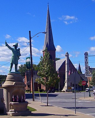
Walden is the largest of three villages of the town of Montgomery in Orange County, New York, United States. The population was 6,818 at the 2020 census. It has the ZIP Code 12586 and the 778 telephone exchange within the 845 area code. Walden is part of the Kiryas Joel−Poughkeepsie−Newburgh, NY Metropolitan Statistical Area as well as the larger New York−Newark−Bridgeport, NY-NJ-CT-PA Combined Statistical Area.
Airmont is a village in the town of Ramapo, Rockland County, New York, United States, located north of the state of New Jersey, east of Suffern, south of Montebello, and west of Chestnut Ridge. The population was 10,166 at the 2020 census.
Hillburn, originally called "Woodburn" and incorporated in 1893, is a village in the town of Ramapo, Rockland County, New York, United States. It is located north of Suffern, east of Orange County, south of Viola, and west of Montebello. It is considered to be one of the more rural communities in Rockland County. The population was 930 at the 2020 census.
Montebello is an incorporated village in Ramapo, Rockland County, New York, United States. It is located north of Suffern, east of Hillburn, south of Wesley Hills, and west of Airmont. The population was 4,507 at the 2020 census.
Ramapo is a town in Rockland County, New York, United States. It was originally formed as New Hampstead, in 1791, and became Ramapo in 1828. It shares its name with the Ramapo River. As of the 2020 census, Ramapo had a total population of 148,919, making it the most populous town in New York outside of Long Island. If all towns in New York were cities, Ramapo would be the 12th-largest city in the state of New York.
Suffern is a village that was incorporated in 1796 in the town of Ramapo in Rockland County, New York. Sitting adjacent to the town of Mahwah, New Jersey, Suffern is located 31 miles northwest of Manhattan. As of the 2020 census, Suffern's population was 11,402.
Wesley Hills is a village in the town of Ramapo, Rockland County, New York, United States. It is located north of Viola, east of Harriman State Park, south of Pomona, and west of New Hempstead. The population was 5,628 at the 2010 census.
New York State Route 17 (NY 17) is a major state highway that extends for 397 miles (638.91 km) through the Southern Tier and Downstate regions of New York in the United States. It begins at the Pennsylvania state line in Mina and follows the Southern Tier Expressway east through Corning to Binghamton and the Quickway from Binghamton east to Woodbury, where it turns south to follow the Orange Turnpike to the New Jersey state line near Suffern, where it connects to New Jersey Route 17. From the Pennsylvania border to the village of Waverly and from Binghamton to Windsor, NY 17 is concurrent with Interstate 86 (I-86). Eventually, the entire east–west portion of NY 17 from the Pennsylvania border to Woodbury will become I-86 as projects to upgrade the route to Interstate Highway standards are completed.
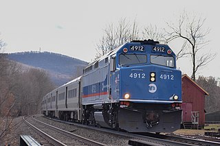
The Port Jervis Line is a predominantly single-track commuter rail line running between Suffern and Port Jervis, in the U.S. state of New York. At Suffern, the line continues south into New Jersey on NJ Transit's Main Line. The line is operated by NJ Transit Rail Operations under a contract with Metro-North Railroad (MNRR).
New York State Route 59 (NY 59) is an east–west state highway in southern Rockland County, New York, in the United States. The route extends for 14.08 miles (22.66 km) from NY 17 in Hillburn to U.S. Route 9W (US 9W) in Nyack. In Suffern, it has a concurrency with US 202 for 0.05 miles (0.08 km). NY 59 runs parallel to the New York State Thruway its entire route. The routing of NY 59 became a state highway in 1911 and was signed as NY 59 in the late 1920s.
Sloatsburg station is a commuter rail stop on the Metro-North Railroad's Port Jervis Line, located in the village of Sloatsburg, New York at the intersection of Municipal Plaza and Mills Street.
Seven Lakes Drive is a north–south parkway located in the Hudson Valley region of New York in the United States. It extends for just under 18 miles (29 km) on a northeast–southwest alignment from an intersection with New York State Route 17 (NY 17) in the village of Sloatsburg to a junction with U.S. Route 9W (US 9W) and US 202 south of the Bear Mountain Bridge in the town of Stony Point. Most of the parkway is located in either Harriman or Bear Mountain state parks, except for a small stretch near its western end. Ownership of Seven Lakes Drive is split between three entities, two of which are also responsible for maintenance of the road.
Suffern Central School District, formerly the Ramapo Central School District, is a school district headquartered in Hillburn, a village in the Town of Ramapo in Rockland County, New York, United States located north of Suffern; east of Orange County, New York; south of Viola and west of Montebello.
The Jacob Sloat House, originally called Harmony Hall, is located on Liberty Rock Road in Sloatsburg, New York, United States. Built in the late 1840s, it is a wooden house that shows the transition from the waning Greek Revival style to the newer Picturesque and Italianate modes.
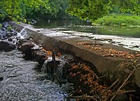
Sloat's Dam and Mill Pond is located between Waldron Terrace and Ballard Avenue in Sloatsburg, New York, United States. The 200-foot–long concrete dam creates the mill pond north of it by impounding the Ramapo River.
Plattekill is a town in Ulster County, New York, United States. The population was 10,424 in 2020, a slight decrease from 10,499 at the 2010 census. The name is derived from a stream, the Platte Kill.
Monroe is a town in Orange County, New York, United States. The population was 21,387 at the 2020 census, compared to 39,912 at the 2010 census; the significant fall in census population was due to the secession of the town of Palm Tree in 2019. The town is named after President James Monroe.
This page is based on this Wikipedia article Text is available under the CC BY-SA 4.0 license; additional terms may apply. Images, videos and audio are available under their respective licenses.