Clyde Peak

Last updated
Clyde Peak
Clyde Peak, Red Eagle Lake.jpg
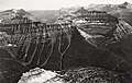
Northeast aspect, reflected in Red Eagle Lake
Highest point
Elevation 8,610 ft (2,624 m) [1]
Prominence 770 ft (235 m) [1]
Parent peak Mount Logan (9,244 ft) [2]
Isolation 1.44 mi (2.32 km) [2]
Coordinates 48°35′17″N113°37′02″W / 48.58806°N 113.61722°W / 48.58806; -113.61722 Coordinates: 48°35′17″N113°37′02″W / 48.58806°N 113.61722°W / 48.58806; -113.61722 [1]
Naming
Etymology Norman Clyde
Geography
USA Montana relief location map.jpg
Red triangle with thick white border.svg
Clyde Peak
Location in Montana
Usa edcp relief location map.png
Red triangle with thick white border.svg
Clyde Peak
Location in the United States
Location Glacier National Park
Flathead County / Glacier County
Montana, U.S.
Parent range Lewis Range
Rocky Mountains
Topo map USGS Mount Stimson
Climbing
First ascent 1923
Easiest route class 3 scrambling [2]

Clyde Peak is an 8,610-foot-elevation (2,620-meter) mountain summit located in Glacier National Park in the U.S. state of Montana. The mountain straddles the border shared by Flathead County and Glacier County. It is situated on the Continental Divide so precipitation runoff from the west side of the mountain drains into Thompson Creek which is part of the Middle Fork Flathead River watershed, and the east side drains into headwaters of Red Eagle Creek, which flows to Red Eagle Lake, thence Saint Mary Lake. It is set in the Lewis Range, and the nearest higher neighbor is Mount Logan 1.44 mile to the northwest. Topographic relief is significant as the southwest aspect rises approximately 4,000 feet (1,200 meters) in one mile.

Contents

Etymology

The mountain's name commemorates Norman Clyde (1885–1972), who made the first ascent of this peak on July 23, 1923. [1] Clyde is credited with 130 first ascents, most of which were in the Sierra Nevada of California. [3] In 1923 he spent 36 days in Glacier National Park, Montana, where he climbed 36 mountains, including 11 first ascents. This geographical feature's name has not yet been officially adopted by the United States Board on Geographic Names.

Geology

Like other mountains in Glacier National Park, Clyde Peak is composed of sedimentary rock laid down during the Precambrian to Jurassic periods. Formed in shallow seas, this sedimentary rock was initially uplifted beginning 170 million years ago when the Lewis Overthrust fault pushed an enormous slab of precambrian rocks 3 mi (4.8 km) thick, 50 miles (80 km) wide and 160 miles (260 km) long over younger rock of the cretaceous period. [4]

Climate

According to the Köppen climate classification system, Clyde Peak is located in an alpine subarctic climate zone with long, cold, snowy winters, and cool to warm summers. [5] Winter temperatures can drop below −10 °F with wind chill factors below −30 °F. Due to its altitude, it receives precipitation all year, as snow in winter, and as thunderstorms in summer. This climate supports the Red Eagle Glacier remnant on the north slope of the peak.

See also

Related Research Articles

<span class="mw-page-title-main">Mount Cleveland (Montana)</span> Mountain in Montana, United States

Mount Cleveland is the highest mountain in Glacier National Park, located in Montana, United States. It is also the highest point in the Lewis Range, which spans part of the northern portion of the park and extends into Canada. It is located approximately 3 mi (4.8 km) southeast of the southern end of Waterton Lake, and approximately 5 mi (8.0 km) south of the US–Canada border. The east side of the future national park was purchased by the federal government from the Blackfoot Confederacy in 1895 during the second term of President Grover Cleveland. According to the United States Board on Geographic Names, the mountain is named for the former president.

<span class="mw-page-title-main">Heavens Peak</span> Mountain in Montana, United States

Heavens Peak is located in the Livingston Range, Glacier National Park in the U.S. state of Montana. Heavens Peak is a little more than 1 mile (1.6 km) north of McPartland Mountain. The mountain's descriptive name first appeared on a map prepared by Lt. George P. Ahern, from 1888-1890 reconnaissance maps prepared by him. This geographical feature's name was officially adopted in 1929 by the United States Board on Geographic Names.

<span class="mw-page-title-main">Going-to-the-Sun Mountain</span> Mountain in Montana, United States

Going-to-the-Sun Mountain is a 9,647-foot (2,940 m) mountain peak located in Glacier National Park in the U.S. state of Montana. It rises dramatically above St. Mary Valley just north of the Going-to-the-Sun Road. The mountain was named by James Willard Schultz in 1888.

<span class="mw-page-title-main">Mount Gould (Montana)</span> Peak on the Continental Divide in Glacier National Park, Montana, United States

Mount Gould is a peak on the Continental Divide in Glacier National Park, Montana, United States. It is the highest point of the Garden Wall, a distinctive ridge of the Lewis Range. It is most notable for its huge, steep east face, which drops 4,000 ft (1,220 m) in only one-half mile (0.8 km). This face provides a backdrop to Grinnell Lake, and is often photographed.

<span class="mw-page-title-main">Pollock Mountain</span>

Pollock Mountain is located in the Lewis Range, Glacier National Park in the U.S. state of Montana. Pollock Mountain is situated along the Continental Divide and is one of the peaks along the Garden Wall and is approximately .6 miles (0.97 km) south of Bishops Cap. The mountain was named by Ross Carter for William C. Pollock, a member of the Indian Commission who along with Walter M. Clements and George Bird Grinnell negotiated with the Blackfeet to consummate the treaty that enabled the Federal Government to purchase the "Ceded Strip" of land, which included all of what is now Glacier National Park to the east of the Continental Divide.

<span class="mw-page-title-main">Split Mountain (Montana)</span>

Split Mountain is located in the Lewis Range, Glacier National Park in the U.S. state of Montana.

<span class="mw-page-title-main">Wahcheechee Mountain</span>

Wahcheechee Mountain is located in the Lewis Range, Glacier National Park in the U.S. state of Montana. Stoney Indian Lake is just northeast of the peak.

<span class="mw-page-title-main">Cloudcroft Peaks</span>

Cloudcroft Peaks is located in the Lewis Range, Glacier National Park in the U.S. state of Montana.

<span class="mw-page-title-main">Olson Mountain</span> Mountain in Glacier National Park, US

Olson Mountain, also known as Mount Olson, is a 7,913-foot-elevation mountain summit located in the Livingston Range, of Glacier National Park in the U.S. state of Montana. Olson Mountain rises more than 3,700 feet (1,100 m) above the western shore of Waterton Lake. The mountain was named for a surveyor on the International Boundary Survey, with the name officially adopted in 1929. The nearest higher peak is Campbell Mountain, 1.13 miles (1.82 km) to the north, and Citadel Peaks is two miles to the south. Precipitation runoff from the mountain drains into Olson Creek before it empties to Waterton Lake.

<span class="mw-page-title-main">Stanton Mountain</span> Mountain summit in the Livingston Range

Stanton Mountain is a 7,750 feet (2,360 m) mountain summit located in the Livingston Range, of Glacier National Park in the U.S. state of Montana. Stanton Mountain rises more than 4,500 feet (1,400 m) above the northern shore of Lake McDonald. The mountain's name refers to Mrs. Lottie Stanton who lived near the west side of the park in the late 1800s, and with her husband operated a livery stable in historic Demersville. She was a pioneering woman who followed the construction camps during the railroad building days. The mountain's name was officially adopted in 1929. In the late 1800s it was known as Mt. Lottie Stanton. The nearest higher peak is Mount Vaught, 1.38 miles (2.22 km) to the northeast. Precipitation runoff from the mountain drains into tributaries of the Flathead River.

<span class="mw-page-title-main">Calf Robe Mountain</span>

Calf Robe Mountain is a 7,948-foot-elevation (2,423-meter) mountain summit located in Glacier National Park in the U.S. state of Montana. It is situated on the Continental Divide in the Lewis Range, and can be seen from Highway 2 midway between Marias Pass and East Glacier Park. The summit is set on the border shared by Flathead County and Glacier County. Topographic relief is significant as the east aspect rises 2,500 feet in one mile. The immediate area between the mountain and highway is known for its aspen and beaver dams.

<span class="mw-page-title-main">Red Crow Mountain</span>

Red Crow Mountain is a 7,891-foot-elevation (2,405-meter) mountain summit located in Glacier National Park in the U.S. state of Montana. The summit is set on the border shared by Flathead County and Glacier County. It is situated on the Continental Divide so precipitation runoff from the east side of the mountain drains into Railroad Creek which is part of the Two Medicine River watershed, and the west side drains to Ole Creek, which is a tributary of Middle Fork Flathead River. It is set in the Lewis Range, 6.5 miles southwest of East Glacier Park Village. Topographic relief is significant as the east aspect rises approximately 2,000 feet in one mile. The nearest higher neighbor is Calf Robe Mountain 1.2 mile to the southeast, with Firebrand Pass forming the saddle between these two peaks.

<span class="mw-page-title-main">Haystack Butte</span>

Haystack Butte is a 7,486-foot-elevation (2,282-meter) summit located in the Lewis Range, of Glacier National Park in the U.S. state of Montana. It is situated one mile west of the Continental Divide, in Flathead County, above the Weeping Wall on its south slope. Topographic relief is significant as the west aspect rises 3,900 feet above McDonald Creek in less than 1.5 mile. It can be seen from Logan Pass, and from Going-to-the-Sun Road which traverses the west and south slopes of the peak. The nearest higher neighbor is Mount Gould, 1.07 miles (1.72 km) to the northeast. Climbing access is via the Highline Trail. This geographical feature's descriptive name was on maps as early as 1904, and was officially adopted March 6, 1929, by the United States Board on Geographic Names

<span class="mw-page-title-main">Scenic Point</span>

Scenic Point is a 7,522-foot-elevation (2,293-meter) mountain summit located in the Two Medicine area of Glacier National Park, in Glacier County, Montana, United States. It is situated in the Lewis Range, six miles northwest of East Glacier Park Village, and approximately seven miles east of the Continental Divide, with precipitation runoff from the mountain draining into the Two Medicine River watershed. Topographic relief is significant as the north aspect rises over 2,600 feet above Lower Two Medicine Lake in one mile. Access to the summit is via the Continental Divide National Scenic Trail which traverses the upper slopes of this mountain. The trail to Scenic Point was constructed by the Great Northern Railway, and the summit once hosted a locomotive bell, a Swiss Alps tradition. The mountain's name was officially adopted in 1929 by the United States Board on Geographic Names.

<span class="mw-page-title-main">Spot Mountain</span> Mountain summit in Montana, USA

Spot Mountain is a 7,831-foot-elevation (2,387-meter) mountain summit located in the Two Medicine area of Glacier National Park, in Glacier County, Montana, United States. It is situated in the Lewis Range, nine miles northwest of East Glacier Park Village, and approximately five miles east of the Continental Divide. Precipitation runoff from the mountain drains into tributaries of Cut Bank Creek and Two Medicine River, which merge to form the Marias River. Topographic relief is significant as the south aspect rises nearly 3,000 feet above Lower Two Medicine Lake in two miles. The mountain's name was officially adopted in 1929 by the United States Board on Geographic Names.

<span class="mw-page-title-main">Citadel Peaks</span>

Citadel Peaks is a mountain ridge located in the Goat Haunt area of Glacier National Park, in Glacier County of the U.S. state of Montana. This arête with a row of sharp points is part of the Livingston Range, and is approximately four miles east of the Continental Divide. Neighbors include Olson Mountain, two miles (3.2 km) to the north, Mount Cleveland four miles (6.4 km) to the east, and Kootenai Peak 2.7 miles (4.3 km) to the south. Topographic relief is significant as Citadel Peaks rises over 3,800 feet above Waterton Lake in less than two miles, and 3,000 feet above Lake Janet in one mile. Precipitation runoff from the mountain drains to the south end of Waterton Lake. The first ascent of Citadel Spire, a major pinnacle on the ridge, was made in 1967 by Jerry Kanzler, Jim Kanzler, Ray Martin, and Clare Pogreba. This geographical feature's name was officially adopted in 1929 by the United States Board on Geographic Names. To the Pikuni people, Citadel Peaks is known as "Ataniawxis", meaning "The Needles".

<span class="mw-page-title-main">Porcupine Ridge</span> Mountain ridge in Montana, US

Porcupine Ridge is a prominent mountain ridge located in the Goat Haunt area of Glacier National Park, in Glacier County of the U.S. state of Montana. This mountain is part of the Livingston Range, and is situated 1.5 mile east of the Continental Divide. Topographic relief is significant as the summit rises approximately 3,900 feet above Lake Frances in one mile, and nearly 5,000 feet above Waterton Lake in five miles. Precipitation runoff from the mountain drains to the Waterton River via Olson and Valentine Creeks. This geographical feature's name was officially adopted in 1911 by the United States Board on Geographic Names.

<span class="mw-page-title-main">Crypt Peak</span> Mountain summit in Glacier National Park

Crypt Peak is an 8,579-foot (2,615 m) mountain summit located in Glacier National Park, in Glacier County of the U.S. state of Montana. It is situated along the Canada–United States border, above Crypt Lake, and is partially within Waterton Lakes National Park. Crypt Peak is part of the Lewis Range, and is approximately three miles east of Waterton Lake. Topographic relief is significant as Crypt Peak rises over 2,100 feet above Crypt Lake in approximately one-half mile (1.6 km), and 4,400 ft (1,340 m) above Waterton Lake in three miles (4.8 km). Precipitation runoff from the mountain drains west to Waterton Lake, and east to Belly River. This geographical feature's name has not yet been officially adopted by the United States Board on Geographic Names.

<span class="mw-page-title-main">Pentagon Mountain</span>

Pentagon Mountain is an 8,873-foot (2,704-metre) mountain summit located in Flathead County of the U.S. state of Montana.

<span class="mw-page-title-main">Gable Peaks</span>

Gable Peaks is a remote 7,700-foot (2,347-metre) double summit mountain located in Flathead County of the U.S. state of Montana.

References

  1. 1 2 3 4 "Clyde Peak, Montana". Peakbagger.com. Retrieved 2021-08-20.
  2. 1 2 3 "Clyde Peak - 8,610' MT". listsofjohn.com. Retrieved 2021-08-20.
  3. Norman Clyde - Mountaineer, Owensvalleyhistory.com
  4. Gadd, Ben (2008). "Geology of the Rocky Mountains and Columbias".{{cite journal}}: Cite journal requires |journal= (help)
  5. Peel, M. C.; Finlayson, B. L.; McMahon, T. A. (2007). "Updated world map of the Köppen−Geiger climate classification". Hydrol. Earth Syst. Sci. 11 (5): 1633. Bibcode:2007HESS...11.1633P. doi:10.5194/hess-11-1633-2007. ISSN   1027-5606. S2CID   9654551.