Columbus, Kentucky

Last updated

Columbus, Kentucky
Columbus-water-tower-ky.jpg
Water tower in Columbus
Hickman County Kentucky Incorporated and Unincorporated areas Columbus Highlighted 2116768.svg
Location of Columbus in Hickman County, Kentucky.
Coordinates: 36°45′37″N89°6′10″W / 36.76028°N 89.10278°W / 36.76028; -89.10278
Country United States
State Kentucky
County Hickman
Area
[1]
  Total0.32 sq mi (0.83 km2)
  Land0.32 sq mi (0.82 km2)
  Water0.00 sq mi (0.00 km2)
Elevation
459 ft (140 m)
Population
 (2020)
  Total140
  Density440.25/sq mi (169.85/km2)
Time zone UTC-6 (Central (CST))
  Summer (DST) UTC-5 (CDT)
ZIP code
42032
Area code(s) 270 & 364
FIPS code 21-16768
GNIS feature ID0489887

Columbus is a home rule-class city in Hickman County, Kentucky, in the United States. The population was 140 at the 2020 census, a decline from 229 in 2000. The city lies at the western end of the state, less than a mile from the Mississippi River.

Contents

Columbus-Belmont State Park borders the city to the west.

History

Downtown Columbus, c. 1920 Columbus, Hickman County, Kentucky.jpg
Downtown Columbus, c. 1920
A system map of the M&O in 1903, by which time it had expanded north to St. Louis 1903 Poor's Mobile and Ohio Railroad.jpg
A system map of the M&O in 1903, by which time it had expanded north to St. Louis

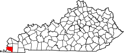
Columbus is the oldest town in Kentucky's Jackson Purchase. It was first settled on the Mississippi floodplain in 1804 and known as "Iron Banks" after the site's French name les rivages de fer. [2] The long-held local rumor that President Thomas Jefferson planned to remove the American capital to the site [3] [4] has absolutely no basis in fact. [2]

The name of the town was changed to Columbus in 1820 (in honor of the Italian explorer), the year the town received its first post office and was formally established by the state assembly. It was the original Hickman County seat before the transfer of the court to the more central location of Clinton. [2] It was formally incorporated in 1860. [5]

In 1861, after the American Civil War broke out, the town was seized by Confederate forces (including the Louisiana "Shreveport Rebels". They fortified the site overlooking the Mississippi River, building Fort de Russey. [6] ) Confederate general Leonidas Polk tried to run and maintain a large anchor chain across the entire Mississippi at Columbus in order to block Union traffic downriver. Columbus was also the northernmost spur on the Mobile and Ohio Railroad. The Union responded by General Ulysses S. Grant's engaging the Confederates at Belmont on the Missouri shore. This was Grant's first direct combat during the war. These actions are today commemorated at the Columbus-Belmont State Park on the bluff near Columbus.

In 1878, the American railroad legend Casey Jones got his first railroad job here, working as a telegrapher for the Mobile and Ohio at the age of 15.

The Great Mississippi Flood of 1927 deluged the town, as well as many areas downriver in the Mississippi Delta, where hundreds of thousands of acres were flooded. Survivors moved the town of Columbus, rebuilding it upon higher ground above the flood plain. Some of the original houses were saved and moved inland. [7]

Given its isolated location in a rural area and the decline in river traffic, the town has lost population for years.

Geography

Columbus is located in northwestern Hickman County at 36°45′37″N89°6′10″W / 36.76028°N 89.10278°W / 36.76028; -89.10278 (36.760176, -89.102840), [8] on high ground 0.6 miles (0.97 km) east of the Mississippi River. It is bordered to the west by Columbus-Belmont State Park, which occupies a bluff rising nearly 200 feet (61 m) above the river.

Kentucky Route 58 leads southeast from Columbus 9 miles (14 km) to Clinton, the county seat. Kentucky Route 123 passes through the center of town, leading south then east 15 miles (24 km) to Clinton and north-northeast 10 miles (16 km) to Bardwell. Via Kentucky Route 80 it is 6 miles (10 km) east-northeast to Arlington.

According to the United States Census Bureau, the city has a total area of 0.3 square miles (0.8 km2), all land. [1]

Demographics

Historical population
CensusPop.Note
1830 196
1860 963
1870 1,57463.4%
1880 1,338−15.0%
1890 873−34.8%
1900 1,23541.5%
1910 970−21.5%
1920 654−32.6%
1930 513−21.6%
1940 5527.6%
1950 482−12.7%
1960 357−25.9%
1970 3713.9%
1980 296−20.2%
1990 252−14.9%
2000 229−9.1%
2010 170−25.8%
2020 140−17.6%
U.S. Decennial Census [9]

As of the census [10] of 2000, there were 229 people, 95 households, and 60 families residing in the city. The population density was 558.6 inhabitants per square mile (215.7/km2). There were 110 housing units at an average density of 268.3 per square mile (103.6/km2). The racial makeup of the city was 77.29% White, 17.90% Black or African American, 2.18% from other races, and 2.62% from two or more races. Hispanic or Latino of any race were 4.80% of the population.

There were 95 households, out of which 27.4% had children under the age of 18 living with them, 49.5% were married couples living together, 12.6% had a female householder with no husband present, and 35.8% were non-families. 31.6% of all households were made up of individuals, and 12.6% had someone living alone who was 65 years of age or older. The average household size was 2.41 and the average family size was 3.11.

In the city, the population was spread out, with 23.1% under the age of 18, 13.5% from 18 to 24, 26.2% from 25 to 44, 24.0% from 45 to 64, and 13.1% who were 65 years of age or older. The median age was 35 years. For every 100 females, there were 102.7 males. For every 100 females age 18 and over, there were 95.6 males.

The median income for a household in the city was $25,313, and the median income for a family was $29,844. Males had a median income of $21,667 versus $14,500 for females. The per capita income for the city was $11,766. About 5.1% of families and 9.1% of the population were below the poverty line, including 13.5% of those under the age of eighteen and 8.3% of those 65 or over.

Climate

The climate in this area is characterized by hot, humid summers and generally mild to cool winters. According to the Köppen Climate Classification system, Columbus has a humid subtropical climate, abbreviated "Cfa" on climate maps. [11]

Related Research Articles

<span class="mw-page-title-main">Hickman County, Kentucky</span> County in Kentucky, United States

Hickman County is a county located in the U.S. state of Kentucky. As of the 2020 census, the population was 4,521, making it the third-least populous county in Kentucky. Its county seat is Clinton. The county was formed in 1821. It is the least densely populated county in the state and is a prohibition or dry county.

<span class="mw-page-title-main">Fulton County, Kentucky</span> County in Kentucky, United States

Fulton County is the westernmost county in the U.S. state of Kentucky, with the Mississippi River forming its western boundary. As of the 2020 census, the population was 6,515. Its county seat is Hickman and its largest city is Fulton. The county was formed in 1845 from Hickman County, Kentucky and named for Robert Fulton, the inventor of the steamboat.

<span class="mw-page-title-main">Wickliffe, Kentucky</span> City in Kentucky, United States

Wickliffe is a home rule-class city and the county seat of Ballard County, Kentucky, United States. The population was 670 at the 2020 census.

<span class="mw-page-title-main">Bardwell, Kentucky</span> City in Kentucky, United States

Bardwell is a home rule-class city in and the county seat of Carlisle County, Kentucky, United States. The city was formally incorporated by the state assembly in 1878. The population was 714 at the 2020 census, down from 723 in 2010. Bardwell is included in the Paducah, KY-IL Metropolitan Statistical Area.

<span class="mw-page-title-main">Carrollton, Kentucky</span> City in Kentucky, United States

Carrollton is a home rule-class city in—and the county seat of—Carroll County, Kentucky, United States, at the confluence of the Ohio and Kentucky rivers. The population was 3,938 at the 2010 census.

<span class="mw-page-title-main">Ghent, Kentucky</span> City in Kentucky, United States

Ghent is a home rule-class city along the south bank of the Ohio River in Carroll County, Kentucky, in the United States. The population was 323 at the 2010 census.

<span class="mw-page-title-main">Hickman, Kentucky</span> City in Kentucky, United States

Hickman is a city in and the county seat of Fulton County, Kentucky, United States. Located on the Mississippi River, the city had a population of 2,365 at the 2020 U.S. census and is classified as a home rule-class city. Hickman is part of the Union City micropolitan area.

<span class="mw-page-title-main">Madisonville, Kentucky</span> City in Kentucky, United States

Madisonville is a home rule-class city in and the county seat of Hopkins County, Kentucky, United States, located along Interstate 69 in the state's Western Coal Fields region. The population was 19,591 at the 2010 census. Madisonville is a commercial center of the region and is home to Madisonville Community College.

<span class="mw-page-title-main">Blaine, Kentucky</span> City in Kentucky, United States

Blaine is a home rule-class city in Lawrence County, Kentucky, United States. The population was 47 at the 2010 census, down from 245 at the 2000 census.

<span class="mw-page-title-main">Hyden, Kentucky</span> City in Kentucky, United States

Hyden is a home rule-class city in and the county seat of Leslie County, Kentucky, United States. The population was 365 at the 2010 census. It is located at the junction of U.S. Route 421 and Kentucky Route 80, along the Middle Fork of the Kentucky River.

<span class="mw-page-title-main">Kuttawa, Kentucky</span> City in Kentucky, United States

Kuttawa is a home rule-class city in Lyon County, Kentucky, in the United States. The population was 649 as of the 2010 census, up from 596 in 2000.

<span class="mw-page-title-main">Calhoun, Kentucky</span> City in Kentucky, United States

Calhoun is a home rule-class city in McLean County, Kentucky, United States. The population was 725 at the 2020 census. It is the county seat of McLean County. It is included in the Owensboro, Kentucky Metropolitan Statistical Area.

<span class="mw-page-title-main">Mount Sterling, Kentucky</span> City in Kentucky, United States

Mount Sterling, often written as Mt. Sterling, is a home rule-class city in Montgomery County, Kentucky, United States. The population was 7,558 as of the 2020 census, up from 6,895 in 2010. It is the county seat of Montgomery County and the principal city of the Mount Sterling micropolitan area.

<span class="mw-page-title-main">Hickory Flat, Mississippi</span> Town in Mississippi, United States

Hickory Flat is a town in Benton County, Mississippi, United States. The population was 601 at the 2010 census.

<span class="mw-page-title-main">Hernando, Mississippi</span> City in Mississippi, United States

Hernando is the county seat of DeSoto County, on the northwestern border of Mississippi, United States. The population was 17,138 according to the 2020 census records. DeSoto County is the second-most-populous county in the Memphis metropolitan area, which includes counties in Tennessee, Arkansas and Mississippi.

<span class="mw-page-title-main">Canton, Mississippi</span> City in Mississippi, United States

Canton is a city in Madison County, Mississippi, United States. The population was 10,948 at the 2020 census, down from 13,189 in 2010. It is the county seat of Madison County, and is situated in the northern part of the metropolitan area surrounding the state capital, Jackson.

<span class="mw-page-title-main">Aberdeen, Mississippi</span> City in Mississippi, United States

Aberdeen is the county seat of Monroe County, Mississippi, United States. As of the 2020 census, the population was 4,961, down from 5,612 in 2010.

<span class="mw-page-title-main">Martins Ferry, Ohio</span> City in Ohio, United States

Martins Ferry is the most populous city in Belmont County, Ohio, United States. The population was 6,260 as of the 2020 census. Located along the Ohio River across from Wheeling, West Virginia, it is part of the Wheeling metropolitan area.

<span class="mw-page-title-main">Echo, Oregon</span> City in Oregon, United States

Echo is a city in Umatilla County, Oregon, United States. The population was 699 at the 2010 census. It is part of the Pendleton–Hermiston Micropolitan Statistical Area.

<span class="mw-page-title-main">Dawson Springs, Kentucky</span> City in Kentucky, United States

Dawson Springs is a home rule-class city in Hopkins and Caldwell counties in the U.S. state of Kentucky. As of the 2020 census, the population of the city was 2,452.

References

  1. 1 2 "2020 U.S. Gazetteer Files". United States Census Bureau. Retrieved March 18, 2022.
  2. 1 2 3 Rennick, Robert M. Kentucky Place Names . The University Press of Kentucky (Lexington), 1988. ISBN   0-8131-0179-4.
  3. "The History of Columbus, Kentucky Historical Marker". www.hmdb.org. Retrieved January 19, 2022.
  4. Bailey, Bill (1995). "Columbus-Belmont State Park". Kentucky State Parks. Saginaw, Michigan: Glovebox Guidebooks of America. ISBN   1-881139-13-1.
  5. Commonwealth of Kentucky. Office of the Secretary of State. Land Office. "Columbus Archived 2013-07-14 at archive.today ". Accessed 14 July 2013.
  6. John D. Winters, The Civil War in Louisiana, Baton Rouge: Louisiana State University Press, 1963, ISBN   0-8071-0834-0, p. 42
  7. "The History of Columbus, Kentucky". The Historical Marker Database. Retrieved August 17, 2012.
  8. "US Gazetteer files: 2010, 2000, and 1990". United States Census Bureau. February 12, 2011. Retrieved April 23, 2011.
  9. "Census of Population and Housing". Census.gov. Retrieved June 4, 2015.
  10. "U.S. Census website". United States Census Bureau . Retrieved January 31, 2008.
  11. "Columbus, Kentucky Köppen Climate Classification (Weatherbase)". Weatherbase.