Hickman County | |
---|---|
Coordinates: 36°41′N88°59′W / 36.68°N 88.98°W | |
Country | United States |
State | Kentucky |
Founded | 1821 |
Named for | Paschal Hickman |
Seat | Clinton |
Largest city | Clinton |
Area | |
• Total | 253 sq mi (660 km2) |
• Land | 242 sq mi (630 km2) |
• Water | 11 sq mi (30 km2) 4.3% |
Population (2020) | |
• Total | 4,521 |
• Estimate (2023) | 4,447 |
• Density | 18/sq mi (6.9/km2) |
Time zone | UTC−6 (Central) |
• Summer (DST) | UTC−5 (CDT) |
Congressional district | 1st |
Website | hickmancounty |
Hickman County is a county located in the U.S. state of Kentucky. As of the 2020 census, the population was 4,521, [1] making it the third-least populous county in Kentucky. Its county seat is Clinton. [2] The county was formed in 1821. [3] It is the least densely populated county in the state and is a prohibition or dry county.
Founded in 1821, Hickman County was the seventy-first in order of formation. It was named for Captain Paschal Hickman of the 1st Rifle Regiment, Kentucky Militia. [4] [5] A resident of Franklin County, Kentucky, Hickman was wounded and captured at the Battle of Frenchtown in January 1813 and was killed by Indians in the Massacre of the River Raisin.
Columbus, Kentucky, in the northwest of the county and located on the Mississippi River, was the original county seat. A log structure built in 1823 served as the courthouse. In 1830, the county seat was moved to the more centrally located Clinton. Since 1845 when Fulton County, Kentucky was partitioned, Hickman County has maintained its current borders.
In 1861, early in the American Civil War, the Confederate Army established Fort de Russey on the strategically located bluffs at Columbus across the river from Belmont, Missouri. Confederate General Leonidas Polk knew it was important to control the river, and wanted to extend a massive chain across the Mississippi to block Union forces from going downstream. (This was never achieved.) The fort was garrisoned with several thousand troops and a six-gun battery was installed; a smaller force was based at a Confederate camp in Belmont.
Union Gen. Ulysses S. Grant moved troops from his base at Cairo, Illinois, and attacked Belmont in November 1861, his first battle of the war. He was ultimately defeated by Confederate troops sent from Columbus across the river to reinforce the Confederate defense; they were led by Polk. [6] [7] The former site of the Confederate fortifications near Columbus, Kentucky is now the Columbus-Belmont State Park, commemorating all the actions of the day that led to Union defeat here. [8]
According to the U.S. Census Bureau, the county has a total area of 253 square miles (660 km2), of which 242 square miles (630 km2) is land and 11 square miles (28 km2) (4.3%) is water. [9] The elevation in the county ranges from 276 to 510 feet (84 to 155 m) above sea level. The county's western border is formed by the Mississippi River, nearly a mile wide here, with the state of Missouri on the other side. Some portions of the county are landlocked to Missouri west of the Mississippi.
Census | Pop. | Note | %± |
---|---|---|---|
1830 | 5,198 | — | |
1840 | 8,968 | 72.5% | |
1850 | 4,791 | −46.6% | |
1860 | 7,008 | 46.3% | |
1870 | 8,453 | 20.6% | |
1880 | 10,651 | 26.0% | |
1890 | 11,637 | 9.3% | |
1900 | 11,745 | 0.9% | |
1910 | 11,750 | 0.0% | |
1920 | 10,244 | −12.8% | |
1930 | 8,725 | −14.8% | |
1940 | 9,142 | 4.8% | |
1950 | 7,778 | −14.9% | |
1960 | 6,747 | −13.3% | |
1970 | 6,264 | −7.2% | |
1980 | 6,065 | −3.2% | |
1990 | 5,566 | −8.2% | |
2000 | 5,262 | −5.5% | |
2010 | 4,902 | −6.8% | |
2020 | 4,521 | −7.8% | |
2023 (est.) | 4,447 | [10] | −1.6% |
U.S. Decennial Census [11] 1790-1960 [12] 1900-1990 [13] 1990-2000 [14] 2010-2021 [15] |
As of the census [16] of 2000, there were 5,262 people, 2,188 households, and 1,542 families residing in the county. The population density was 22 per square mile (8.5/km2). There were 2,436 housing units at an average density of 10 per square mile (3.9/km2). The racial makeup of the county was 88.35% White, 9.90% Black or African American, 0.29% Native American, 0.06% Asian, 0.17% from other races, and 1.24% from two or more races. 1.03% of the population were Hispanic or Latino of any race.
There were 2,188 households, out of which 28.20% had children under the age of 18 living with them, 56.50% were married couples living together, 10.80% had a female householder with no husband present, and 29.50% were non-families. 27.60% of all households were made up of individuals, and 13.00% had someone living alone who was 65 years of age or older. The average household size was 2.34 and the average family size was 2.82.
In the county, the population was spread out, with 22.10% under the age of 18, 6.90% from 18 to 24, 26.70% from 25 to 44, 25.90% from 45 to 64, and 18.50% who were 65 years of age or older. The median age was 41 years. For every 100 females there were 91.30 males. For every 100 females age 18 and over, there were 88.90 males.
The median income for a household in the county was $31,615, and the median income for a family was $37,049. Males had a median income of $28,438 versus $18,506 for females. The per capita income for the county was $17,279. About 14.20% of families and 17.40% of the population were below the poverty line, including 27.70% of those under age 18 and 13.80% of those age 65 or over.
Year | Republican | Democratic | Third party | |||
---|---|---|---|---|---|---|
No. | % | No. | % | No. | % | |
2020 | 1,714 | 77.94% | 458 | 20.83% | 27 | 1.23% |
2016 | 1,657 | 76.82% | 449 | 20.82% | 51 | 2.36% |
2012 | 1,431 | 66.90% | 686 | 32.07% | 22 | 1.03% |
2008 | 1,406 | 62.49% | 812 | 36.09% | 32 | 1.42% |
2004 | 1,395 | 59.56% | 926 | 39.54% | 21 | 0.90% |
2000 | 1,151 | 54.19% | 940 | 44.26% | 33 | 1.55% |
1996 | 695 | 31.98% | 1,220 | 56.14% | 258 | 11.87% |
1992 | 861 | 35.04% | 1,296 | 52.75% | 300 | 12.21% |
1988 | 1,142 | 49.33% | 1,158 | 50.02% | 15 | 0.65% |
1984 | 1,380 | 56.63% | 1,049 | 43.04% | 8 | 0.33% |
1980 | 1,143 | 42.84% | 1,456 | 54.57% | 69 | 2.59% |
1976 | 585 | 21.54% | 2,035 | 74.93% | 96 | 3.53% |
1972 | 1,430 | 56.66% | 976 | 38.67% | 118 | 4.68% |
1968 | 623 | 23.19% | 880 | 32.76% | 1,183 | 44.04% |
1964 | 613 | 22.10% | 2,149 | 77.47% | 12 | 0.43% |
1960 | 968 | 30.79% | 2,176 | 69.21% | 0 | 0.00% |
1956 | 785 | 24.82% | 2,367 | 74.83% | 11 | 0.35% |
1952 | 871 | 30.40% | 1,988 | 69.39% | 6 | 0.21% |
1948 | 326 | 12.26% | 2,143 | 80.59% | 190 | 7.15% |
1944 | 588 | 22.60% | 2,005 | 77.06% | 9 | 0.35% |
1940 | 490 | 15.05% | 2,758 | 84.73% | 7 | 0.22% |
1936 | 385 | 13.04% | 2,548 | 86.31% | 19 | 0.64% |
1932 | 446 | 11.77% | 3,327 | 87.81% | 16 | 0.42% |
1928 | 767 | 26.12% | 2,163 | 73.67% | 6 | 0.20% |
1924 | 618 | 21.27% | 2,270 | 78.14% | 17 | 0.59% |
1920 | 866 | 22.01% | 3,045 | 77.40% | 23 | 0.58% |
1916 | 539 | 21.05% | 1,982 | 77.42% | 39 | 1.52% |
1912 | 365 | 17.66% | 1,540 | 74.50% | 162 | 7.84% |
1908 | 658 | 25.44% | 1,890 | 73.09% | 38 | 1.47% |
1904 | 702 | 28.68% | 1,680 | 68.63% | 66 | 2.70% |
1900 | 862 | 30.98% | 1,876 | 67.43% | 44 | 1.58% |
1896 | 727 | 26.53% | 1,928 | 70.36% | 85 | 3.10% |
1892 | 460 | 24.31% | 1,155 | 61.05% | 277 | 14.64% |
1888 | 383 | 25.31% | 1,053 | 69.60% | 77 | 5.09% |
1884 | 489 | 28.36% | 1,204 | 69.84% | 31 | 1.80% |
1880 | 386 | 26.01% | 1,069 | 72.04% | 29 | 1.95% |
1876 | 381 | 22.44% | 1,317 | 77.56% | 0 | 0.00% |
1872 | 401 | 34.04% | 777 | 65.96% | 0 | 0.00% |
1868 | 41 | 3.99% | 987 | 96.01% | 0 | 0.00% |
1864 | 289 | 56.45% | 223 | 43.55% | 0 | 0.00% |
1860 | 1 | 0.10% | 66 | 6.81% | 902 | 93.09% |
1856 | 0 | 0.00% | 631 | 72.11% | 244 | 27.89% |
1852 | 155 | 29.03% | 379 | 70.97% | 0 | 0.00% |
1848 | 169 | 32.38% | 353 | 67.62% | 0 | 0.00% |
1844 | 304 | 29.12% | 740 | 70.88% | 0 | 0.00% |
1840 | 393 | 36.49% | 684 | 63.51% | 0 | 0.00% |
1836 | 198 | 27.54% | 521 | 72.46% | 0 | 0.00% |
McCracken County is a county located in the far west portion of U.S. state of Kentucky. As of the 2020 census, the population was 67,875. The county seat and only municipality is Paducah. McCracken County was the 78th county formed in the state, having been created in 1825. It is part of the historic Jackson Purchase, territory sold by the Chickasaw people to General Andrew Jackson and Governor Isaac Shelby; this territory was located at the extreme western end of Kentucky.
Weakley County is a county located in the northwest of the U.S. state of Tennessee. As of the 2020 census, the population was 32,902. Its county seat is Dresden. Its largest city is Martin, the home of the University of Tennessee at Martin. The county was established by the Tennessee General Assembly on October 21, 1823, and is named for U.S. Congressman Robert Weakley (1764–1845). Weakley County comprises the Martin, TN Micropolitan Statistical Area.
Ralls County is a county located in the northeastern portion of the U.S. state of Missouri. As of the 2020 census, the population was 10,355. Its county seat is New London. The county was organized November 16, 1820 and named for Daniel Ralls, Missouri state legislator.
Pike County is a county on the eastern border of the U.S. state of Missouri, bounded by the Mississippi River. As of the 2020 census, the population was 17,587. Its county seat is Bowling Green. Its namesake was a city in middle Kentucky, a region from where many early migrants came. The county was organized December 14, 1818, and named for explorer Zebulon Pike. The folksong "Sweet Betsy from Pike" is generally thought to be associated with Pike County, Missouri.
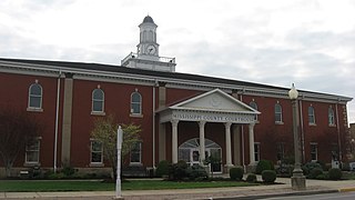
Mississippi County is a county located in the Bootheel of the U.S. state of Missouri, with its eastern border formed by the Mississippi River. As of the 2020 census, the population was 12,577. The largest city and county seat is Charleston. The county was officially organized on February 14, 1845, and was named after the Mississippi River.
Lewis County is a county located in the northeastern portion of the U.S. state of Missouri. As of the 2020 census, the population was 10,032. Its county seat is Monticello. The county was organized January 2, 1833 and named for Meriwether Lewis, the explorer and Governor of the Louisiana Territory.
Lowndes County is a county on the eastern border of the U.S. state of Mississippi. As of the 2020 United States Census, the population was 58,879. Its county seat is Columbus. The county is named for U.S. Congressman William Jones Lowndes.
Lyon County is a county located in the U.S. state of Kentucky. As of the 2020 census, the population was 8,680. Its county seat is Eddyville. The county was formed from Caldwell County, Kentucky in 1854 and named for former Congressman Chittenden Lyon.
Livingston County is a county located in the U.S. state of Kentucky. As of the 2020 census, the population was 8,888. Its county seat is Smithland and its largest community is Ledbetter. The county was established in 1798 from land taken from Christian County and is named for Robert R. Livingston, a member of the Committee of Five that drafted the U.S. Declaration of Independence. The county was strongly pro-Confederate during the American Civil War and many men volunteered for the Confederate Army. Livingston County is part of the Paducah, KY-IL Metropolitan Statistical Area. It is a prohibition or dry county with the exception of Grand Rivers which voted to allow alcohol sales in 2016.
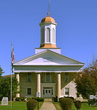
Fulton County is the westernmost county in the U.S. state of Kentucky, with the Mississippi River forming its western boundary. As of the 2020 census, the population was 6,515. Its county seat is Hickman and its largest city is Fulton. The county was formed in 1845 from Hickman County, Kentucky and named for Robert Fulton, the inventor of the steamboat.
Carlisle County is a county located in the U.S. state of Kentucky. As of the 2020 census, the population was 4,826, making it the fourth-least populous county in Kentucky. Its county seat is Bardwell. The county was founded in 1886 and named for John Griffin Carlisle, a Speaker of the United States House of Representatives from Kentucky. It remains a prohibition or dry county. Carlisle County is included in the Paducah, KY-IL, Metropolitan Statistical Area.
Calloway County is a county located in the southwest portion of the U.S. Commonwealth of Kentucky. As of the 2020 census, the population was 37,103. Its county seat is Murray. The county was founded in November 1822 and named for Colonel Richard Callaway, one of the founders of Boonesborough. Calloway County comprises the Murray, KY Micropolitan Statistical Area. As of July 18, 2012 Calloway County is a moist county: the sale of alcohol in the county is prohibited, with the exception of the city of Murray.
Ballard County is a county located in the west portion of the U.S. state of Kentucky. As of the 2020 census, the population was 7,728. Its county seat is Wickliffe and its largest city is LaCenter. The county was created by the Kentucky State Legislature in 1842 and is named for Captain Bland Ballard, a soldier, statesman, and member of the Kentucky General Assembly. Ballard County is part of the Paducah, KY-IL Metropolitan Statistical Area.
Cherokee County is a U.S. county located in Southeast Kansas. Its county seat is Columbus, and its most populous city is Baxter Springs. As of the 2020 census, the county population was 19,362. The county was named for the Cherokee tribe.
Wickliffe is a home rule-class city and the county seat of Ballard County, Kentucky, United States. The population was 670 at the 2020 census.
Hickman is a city in and the county seat of Fulton County, Kentucky, United States. Located on the Mississippi River, the city had a population of 2,365 at the 2020 U.S. census and is classified as a home rule-class city. Hickman is part of the Union City micropolitan area.
Clinton is a home rule-class city and the county seat of Hickman County, Kentucky, United States. The population was 1,388 at the 2010 census, a decline from 1,415 in 2000.
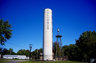
Columbus is a home rule-class city in Hickman County, Kentucky, in the United States. The population was 170 at the 2010 census, a decline from 229 in 2000. The city lies at the western end of the state, less than a mile from the Mississippi River.
Booneville is a home rule-class city in Owsley County, Kentucky, in the United States. The population was 81 at the 2010 census. It is the county seat of Owsley County. It is located at the junction of Kentucky Route 11 and Kentucky Route 30 on the South Fork of the Kentucky River.
Plattsburg is a city in and the county seat of Clinton County, Missouri and is part of the Kansas City metropolitan area in the western part of the state, within the United States. It developed along the Little Platte River. As of the 2020 census, the city population was 2,222.