Bath County | |
---|---|
Coordinates: 38°08′N83°44′W / 38.14°N 83.74°W | |
Country | United States |
State | Kentucky |
Founded | 1811 |
Named for | Medicinal springs located within the county |
Seat | Owingsville |
Largest city | Owingsville |
Area | |
• Total | 284 sq mi (740 km2) |
• Land | 279 sq mi (720 km2) |
• Water | 5.2 sq mi (13 km2) 1.8% |
Population (2020) | |
• Total | 12,750 |
• Estimate (2023) | 12,975 |
• Density | 45/sq mi (17/km2) |
Time zone | UTC−5 (Eastern) |
• Summer (DST) | UTC−4 (EDT) |
Congressional district | 6th |
Website | bathcounty |
Bath County is a county located in the U.S. state of Kentucky. As of the 2020 census, the population was 12,750. [1] The county seat is Owingsville. [2] The county was formed in 1811. [3] Bath County is included in the Mount Sterling, KY Micropolitan Statistical Area, which is also included in the Lexington-Fayette–Richmond–Frankfort, KY combined statistical area.
Bath County was established in 1811 from land given by Montgomery County, Kentucky. Its name is derived from natural springs said to have medicinal qualities. The courthouse in Owingsville was destroyed by an accidental fire caused by Union troops during the American Civil War in 1864. [4]
It is the site of the Kentucky Meat Shower. From 11 a.m. to 12 p.m., on March 3, 1876, a mysterious substance believed to be meat of some sort fell from the sky.
In 1932, an archaeological field survey observed fourteen archaeological sites in Bath County, including the Ramey Mound near Sharpsburg and multiple ancient burials near the Springfield Presbyterian Church. [5]
According to the U.S. Census Bureau, the county has a total area of 284 square miles (740 km2), of which 279 square miles (720 km2) is land and 5.2 square miles (13 km2) (1.8%) is water. [6]
Census | Pop. | Note | %± |
---|---|---|---|
1820 | 7,961 | — | |
1830 | 8,799 | 10.5% | |
1840 | 9,763 | 11.0% | |
1850 | 12,115 | 24.1% | |
1860 | 12,113 | 0.0% | |
1870 | 10,145 | −16.2% | |
1880 | 11,982 | 18.1% | |
1890 | 12,813 | 6.9% | |
1900 | 14,734 | 15.0% | |
1910 | 13,988 | −5.1% | |
1920 | 11,996 | −14.2% | |
1930 | 11,075 | −7.7% | |
1940 | 11,451 | 3.4% | |
1950 | 10,410 | −9.1% | |
1960 | 9,114 | −12.4% | |
1970 | 9,235 | 1.3% | |
1980 | 10,025 | 8.6% | |
1990 | 9,692 | −3.3% | |
2000 | 11,085 | 14.4% | |
2010 | 11,591 | 4.6% | |
2020 | 12,750 | 10.0% | |
2023 (est.) | 12,975 | [7] | 1.8% |
U.S. Decennial Census [8] 1790-1960 [9] 1900-1990 [10] 1990-2000 [11] 2010-2021 [12] |
As of the census [13] of 2000, there were 11,085 people, 4,445 households, and 3,195 families residing in the county. The population density was 40 per square mile (15/km2). There were 4,994 housing units at an average density of 18 per square mile (6.9/km2). The racial makeup of the county was 96.87% White, 1.85% Black or African American, 0.21% Native American, 0.02% Asian, 0.40% from other races, and 0.66% from two or more races. 0.80% of the population were Hispanic or Latino of any race.
There were 4,445 households, out of which 32.30% had children under the age of 18 living with them, 57.70% were married couples living together, 10.30% had a female householder with no husband present, and 28.10% were non-families. 25.30% of all households were made up of individuals, and 12.00% had someone living alone who was 65 years of age or older. The average household size was 2.47 and the average family size was 2.93.
In the county, the population was spread out, with 24.20% under the age of 18, 8.60% from 18 to 24, 28.80% from 25 to 44, 23.80% from 45 to 64, and 14.60% who were 65 years of age or older. The median age was 37 years. For every 100 females, there were 97.60 males. For every 100 females age 18 and over, there were 94.80 males.
The median income for a household in the county was $26,018, and the median income for a family was $31,758. Males had a median income of $27,786 versus $20,986 for females. The per capita income for the county was $15,326. About 16.40% of families and 21.90% of the population were below the poverty line, including 29.60% of those under age 18 and 21.20% of those age 65 or over.
Throughout the 20th century, Bath County was overwhelmingly Democratic, only voting the other way in the Republican landslides of 1928, 1972, and 1984. However, in 2000, George W. Bush flipped the county into the Republican column. Bath County was one of the few counties in Kentucky to flip from Bush to Kerry in 2004. Despite Barack Obama's indomitable midwestern strength in 2008, Bath County was one of the small number of counties to flip from Kerry to McCain that year, although Obama lost it very narrowly. In 2016, Donald Trump won over two-thirds of the vote in Bath County.
Despite its Republican devotion in presidential elections, Bath County still retains loyalty to state and local Democrats, as they have not voted for a Republican gubernatorial candidate since 1919.
Bath County Voter Registration & Party Enrollment as of February 17, 2020 [14] | |||||
---|---|---|---|---|---|
Political Party | Total Voters | Percentage | |||
Democratic | 6,940 | 72.53% | |||
Republican | 2,160 | 22.57% | |||
Others | 354 | 3.70% | |||
Independent | 103 | 1.08% | |||
Libertarian | 8 | 0.08% | |||
Green | 1 | 0.01% | |||
Constitution | 1 | 0.01% | |||
Reform | 1 | 0.01% | |||
Socialist Workers | 1 | 0.01% | |||
Total | 9,569 | 100% |
Year | Republican | Democratic | Third party | |||
---|---|---|---|---|---|---|
No. | % | No. | % | No. | % | |
2020 | 3,986 | 70.84% | 1,573 | 27.95% | 68 | 1.21% |
2016 | 3,082 | 67.19% | 1,361 | 29.67% | 144 | 3.14% |
2012 | 2,275 | 55.19% | 1,770 | 42.94% | 77 | 1.87% |
2008 | 2,234 | 49.17% | 2,210 | 48.65% | 99 | 2.18% |
2004 | 2,269 | 46.13% | 2,608 | 53.02% | 42 | 0.85% |
2000 | 2,303 | 51.49% | 2,087 | 46.66% | 83 | 1.86% |
1996 | 1,229 | 34.43% | 1,886 | 52.83% | 455 | 12.75% |
1992 | 1,259 | 29.95% | 2,229 | 53.02% | 716 | 17.03% |
1988 | 1,614 | 43.34% | 2,099 | 56.36% | 11 | 0.30% |
1984 | 2,020 | 52.88% | 1,781 | 46.62% | 19 | 0.50% |
1980 | 1,463 | 39.56% | 2,174 | 58.79% | 61 | 1.65% |
1976 | 938 | 30.54% | 2,113 | 68.80% | 20 | 0.65% |
1972 | 1,919 | 58.47% | 1,347 | 41.04% | 16 | 0.49% |
1968 | 1,277 | 38.34% | 1,394 | 41.85% | 660 | 19.81% |
1964 | 1,009 | 28.13% | 2,571 | 71.68% | 7 | 0.20% |
1960 | 1,888 | 47.75% | 2,066 | 52.25% | 0 | 0.00% |
1956 | 1,889 | 45.79% | 2,221 | 53.84% | 15 | 0.36% |
1952 | 1,737 | 41.94% | 2,400 | 57.94% | 5 | 0.12% |
1948 | 1,276 | 35.26% | 2,287 | 63.19% | 56 | 1.55% |
1944 | 1,581 | 41.90% | 2,184 | 57.88% | 8 | 0.21% |
1940 | 1,636 | 39.18% | 2,528 | 60.54% | 12 | 0.29% |
1936 | 1,725 | 38.08% | 2,795 | 61.70% | 10 | 0.22% |
1932 | 1,576 | 34.98% | 2,909 | 64.57% | 20 | 0.44% |
1928 | 2,223 | 54.74% | 1,830 | 45.06% | 8 | 0.20% |
1924 | 1,723 | 44.90% | 2,093 | 54.55% | 21 | 0.55% |
1920 | 1,997 | 44.79% | 2,440 | 54.72% | 22 | 0.49% |
1916 | 1,360 | 42.77% | 1,796 | 56.48% | 24 | 0.75% |
1912 | 1,002 | 36.34% | 1,477 | 53.57% | 278 | 10.08% |
Year | Republican | Democratic | Third parties |
---|---|---|---|
2023 | 44.19% 1,515 | 55.81%1,913 | 0.00% 0 |
2019 | 46.09% 1,672 | 51.98%1,886 | 1.93% 70 |
2015 | 46.65% 1,045 | 49.87%1,117 | 3.48% 78 |
2011 | 22.61% 417 | 58.62%1,081 | 18.76% 346 |
2007 | 33.09% 1,136 | 66.91%2,297 | 0.00% 0 |
2003 | 42.56% 1,398 | 57.44%1,887 | 0.00% 0 |
1999 | 15.89% 197 | 55.00%682 | 29.11% 202 |
1995 | 41.41% 1,309 | 58.34%1,844 |
Clinton County is a county located in the U.S. state of Kentucky in the Pennyrile Region along the southern border with Tennessee. As of the 2020 census, the population was 9,253. Its county seat is Albany. The county was formed in 1835 and named for DeWitt Clinton, the seventh Governor of New York. It is a prohibition or dry county.
Wolfe County is a county located in the U.S. state of Kentucky. As of the 2020 census, the population was 6,562. Its county seat is Campton. The county is named for Nathaniel Wolfe.
Taylor County is a county located in the U.S. state of Kentucky. As of the 2020 census, the population was 26,023. Its county seat is Campbellsville. Settled by people from Virginia, Pennsylvania, Maryland, and North Carolina after the American Revolutionary War, the county was organized in 1848 in the Highland Rim region. It is named for United States Army General Zachary Taylor, later President of the United States. Taylor County was the 100th of the 120 counties created by Kentucky. The Campbellsville Micropolitan Statistical Area includes all of Taylor County.
Simpson County is a county located in the south central portion of the U.S. state of Kentucky. As of the 2020 census, the total population was 19,594. Its county seat is Franklin.
Russell County is a county located in the U.S. Commonwealth of Kentucky. As of the 2020 census, the population was 17,991. Its county seat is Jamestown and its largest city is Russell Springs. The county was formed on December 14, 1825, from portions of Adair, Cumberland and Wayne Counties and is named for William Russell.
Rockcastle County is a county located in the southeastern part of the U.S. state of Kentucky. As of the 2020 census, the population was 16,037. Its county seat is Mt. Vernon. The county was founded in 1810 and named for the Rockcastle River, which runs through it. The river, in turn, is named for its majestic rock cliffs. Rockcastle County is part of the Richmond-Berea, KY Micropolitan Statistical Area, which is also included in the Lexington-Fayette–Richmond–Frankfort, KY combined statistical area.
Powell County is a county located in the U.S. Commonwealth of Kentucky. As of the 2020 census, the population was 13,129. Its county seat is Stanton. The county was formed January 7, 1852, by Kentucky Governor Lazarus W. Powell from parts of Clark, Estill, and Montgomery counties. It is no longer a dry county as of 2018. Powell County is home to Natural Bridge State Resort Park and the Red River Gorge Geologic Area, two of Kentucky's most important natural areas and ecotourism destinations, as well as the Pilot Knob State Nature Preserve.
Morgan County is a county located in the U.S. state of Kentucky. As of the 2020 census, the population was 13,726. Its county seat is West Liberty. The county is among the dry counties, which means that the sale of alcohol is restricted or prohibited.
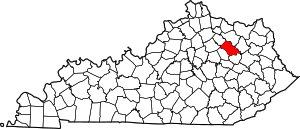
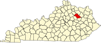
Menifee County is a county located in the U.S. state of Kentucky. As of the 2020 census, the population was 6,113, making it the fifth-least populous county in Kentucky. Its county seat is Frenchburg. The county is named for Richard Hickman Menefee, U.S. Congressman, although the spelling has changed. It is a prohibition or dry county. Menifee County is part of the Mount Sterling, KY Micropolitan Statistical Area, which is also included in the Lexington-Fayette–Richmond–Frankfort, KY combined statistical area. It is located in the foothills of the Cumberland Plateau.
Lincoln County is a county located in south-central Kentucky. As of the 2020 census, the population was 24,275. Its county seat is Stanford. Lincoln County is part of the Danville, KY Micropolitan Statistical Area.
Fleming County is a county located in the U.S. state of Kentucky. As of the 2020 census, the population was 15,082. Its county seat is Flemingsburg. The county was formed in 1798 and named for Colonel John Fleming, an Indian fighter and early settler. It is a moist county. In 1998, the Kentucky General Assembly designated Fleming County as the Covered Bridge Capital of Kentucky.
Carter County is a county located in the U.S. state of Kentucky. As of the 2020 census, the population was 26,627. Its county seat is Grayson. Carter County is in the Huntington-Ashland, WV-KY-OH Metropolitan Statistical Area. It is home to Carter Caves State Resort Park.
Carroll County is a county located in the northern part of the U.S. state of Kentucky. Its county seat is Carrollton. The county was formed in 1838 and named for Charles Carroll of Carrollton, the last living signer of the Declaration of Independence. It is located at the confluence of the Kentucky and Ohio Rivers.
Christian County is a county located in the U.S. state of Illinois. As of the 2020 census, the population was 34,032. Its county seat is Taylorville.
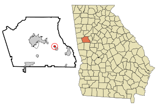
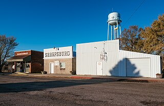
Sharpsburg (ˈʃɑrpsbɝg) is a town in Coweta County, Georgia, United States. It is part of the Atlanta metropolitan area. Its population was 327 at the 2020 census.
Sharpsburg is a city in Taylor County, Iowa, United States. The population was 72 at the time of the 2020 census.
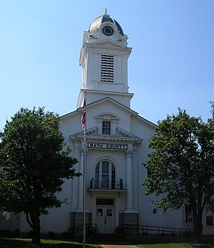
Owingsville is a home rule-class city in Bath County, Kentucky, in the United States. The population was 1,530 during the year 2010 U.S. Census. It is the county seat and is located roughly at the county's center, at the junction of US 60 and Kentucky 36. It is part of the Mount Sterling micropolitan area.
Sharpsburg is a home rule-class city in Bath County, Kentucky, in the United States. The population was 323 as of the 2010 U.S. census. It is part of the Mount Sterling micropolitan area.
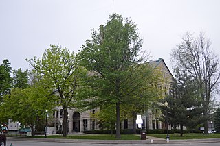
Frenchburg is a home rule-class city in Menifee County, Kentucky, in the United States. The population was 601 at the 2020 census, up from 486 in 2010. It is the seat and only incorporated city in its rural county. It is located at the junction of U.S. Route 460 and Kentucky Route 36. Logging is the primary industry.
Sharpsburg is a town in Edgecombe, Nash, and Wilson counties, North Carolina, United States. It is part of the Rocky Mount, North Carolina Metropolitan Statistical Area. The population was 2,024 at the 2010 Census.
{{cite web}}
: CS1 maint: archived copy as title (link)