Casey County, Kentucky

Last updated

Casey County
Casey County Courthouse.jpg
Casey County courthouse in Liberty
Map of Kentucky highlighting Casey County.svg
Location within the U.S. state of Kentucky
Kentucky in United States.svg
Kentucky's location within the U.S.
Coordinates: 37°19′N84°56′W / 37.32°N 84.93°W / 37.32; -84.93
CountryFlag of the United States.svg United States
StateFlag of Kentucky.svg  Kentucky
FoundedNovember 14, 1806
Named for Colonel William Casey
Seat Liberty
Largest cityLiberty
Area
  Total446 sq mi (1,160 km2)
  Land444 sq mi (1,150 km2)
  Water1.5 sq mi (4 km2)  0.3%
Population
 (2020)
  Total15,941
  Estimate 
(2023)
15,918 Decrease2.svg
  Density36/sq mi (14/km2)
Time zone UTC−5 (Eastern)
  Summer (DST) UTC−4 (EDT)
Congressional district 1st

Casey County is a county located in the U.S. Commonwealth of Kentucky. As of the 2020 census, the population was 15,941. [1] Its county seat is Liberty. [2] The county was formed in 1806 from the western part of Lincoln County [3] and named for Colonel William Casey, a pioneer settler who moved his family to Kentucky in 1779. [4] It is the only Kentucky county entirely in the Knobs region. Casey County is home to annual Casey County Apple Festival, and is a prohibition or dry county. It is considered part of the Appalachian region of Kentucky.

Contents

History

Casey County was established in 1806 from land given by Lincoln County. The third and present courthouse was built in 1889. [5]

In 2015, County Clerk Casey Davis received national press when he announced he would deny same-sex marriage licenses, as a show of solidarity with fellow county clerk Kim Davis, who was criticized and later jailed for doing the same thing in Rowan County, Kentucky. [6]

Geography

According to the United States Census Bureau, the county has a total area of 446 square miles (1,160 km2), of which 444 square miles (1,150 km2) is land and 1.5 square miles (3.9 km2) (0.3%) is water. [7]

The highest point in Casey County is Green River Knob at 1,789 feet (545 m).

Adjacent counties

Major highways

Demographics

Historical population
CensusPop.Note
1810 3,285
1820 4,34932.4%
1830 4,342−0.2%
1840 4,93913.7%
1850 6,55632.7%
1860 6,466−1.4%
1870 8,88437.4%
1880 10,98323.6%
1890 11,8487.9%
1900 15,14427.8%
1910 15,4792.2%
1920 17,21311.2%
1930 16,747−2.7%
1940 19,96219.2%
1950 17,446−12.6%
1960 14,327−17.9%
1970 12,930−9.8%
1980 14,81814.6%
1990 14,211−4.1%
2000 15,4478.7%
2010 15,9553.3%
2020 15,941−0.1%
2023 (est.)15,918 [8] −0.1%
U.S. Decennial Census [9]
1790-1960 [10] 1900-1990 [11]
1990-2000 [12] 2010-2020 [1]

As of the census of 2000, there were 15,447 people, 6,260 households, and 4,419 families residing in the county. The population density was 35 per square mile (14/km2). There were 7,242 housing units at an average density of 16 per square mile (6.2/km2). The racial makeup of the county was 98.30% White, 0.33% Black or African American, 0.28% Native American, 0.06% Asian, 0.05% Pacific Islander, 0.31% from other races, and 0.66% from two or more races. 1.28% of the population were Hispanic or Latino of any race.

There were 6,260 households, out of which 31.00% had children under the age of 18 living with them, 56.10% were married couples living together, 10.80% had a female householder with no husband present, and 29.40% were non-families. 26.80% of all households were made up of individuals, and 12.60% had someone living alone who was 65 years of age or older. The average household size was 2.44 and the average family size was 2.94.

24.50% of the population was under the age of 18, 8.20% from 18 to 24, 27.50% from 25 to 44, 24.70% from 45 to 64, and 15.10% who were 65 years of age or older. The median age was 38 years. For every 100 females there were 95.60 males. For every 100 females age 18 and over, there were 92.60 males.

The median income for a household in the county was $21,580, and the median income for a family was $27,044. Males had a median income of $22,283 versus $17,885 for females. The per capita income for the county was $12,867. About 20.70% of families and 25.50% of the population were below the poverty line, including 32.10% of those under age 18 and 29.60% of those age 65 or over.

Casey County is the county in the United States with the highest proportion of Midwest Beachy Amish adherents, with 1.11% of the population in 2020 subscribing to the denomination. [13]

Politics

Casey County has one of the longest streaks of voting for Republican Party candidates in presidential elections in Kentucky & nationwide, with its candidates gaining the majority of the vote by wide margins in every election from 1916 on. No Democratic presidential candidate has won more than 30% of the county's vote since Jimmy Carter in 1976.

United States presidential election results for Casey County, Kentucky [14]
Year Republican Democratic Third party
No.%No.%No.%
2020 6,17986.17%91812.80%741.03%
2016 5,48285.14%76711.91%1902.95%
2012 4,90480.51%1,08617.83%1011.66%
2008 4,67978.55%1,21920.46%590.99%
2004 5,10980.83%1,17418.57%380.60%
2000 4,28478.33%1,12220.52%631.15%
1996 3,18765.40%1,10622.70%58011.90%
1992 3,31762.56%1,40926.57%57610.86%
1988 3,85775.38%1,21623.76%440.86%
1984 4,35679.01%1,12220.35%350.63%
1980 4,23975.27%1,29823.05%951.69%
1976 3,37967.15%1,60231.84%511.01%
1972 3,72778.83%91319.31%881.86%
1968 3,69870.64%87916.79%65812.57%
1964 3,45764.54%1,87535.01%240.45%
1960 4,81177.30%1,41322.70%00.00%
1956 4,16772.48%1,57027.31%120.21%
1952 3,83171.39%1,52228.36%130.24%
1948 3,38068.32%1,49530.22%721.46%
1944 3,86971.53%1,52028.10%200.37%
1940 3,87467.34%1,86232.37%170.30%
1936 3,58864.84%1,92534.78%210.38%
1932 3,84058.93%2,65140.68%250.38%
1928 3,80571.39%1,51928.50%60.11%
1924 3,12063.03%1,79736.30%330.67%
1920 3,54364.03%1,95135.26%390.70%
1916 1,94958.37%1,35240.49%381.14%
1912 90231.23%1,15840.10%82828.67%

Education

Casey County Schools operates public schools.

Communities

Notable people

See also

Related Research Articles

<span class="mw-page-title-main">Webster County, Kentucky</span> County in Kentucky, United States

Webster County is a county located in the U.S. state of Kentucky. As of the 2020 census, the population was 13,017. Its county seat is Dixon and its largest city is Providence. It is the southernmost county in the Evansville, IN–KY Metropolitan Statistical Area. The county was formed in 1860 from parts of Henderson, Hopkins, and Union Counties and named for American statesman Daniel Webster (1782–1852). It was mainly pro-Confederate during the American Civil War and was the site of several skirmishes and some guerrilla warfare. Since 2018 it has been a moist county, with Providence and Sebree voting to allow alcohol sales, and Clay doing so in 2022.

<span class="mw-page-title-main">Wayne County, Kentucky</span> County in Kentucky, United States

Wayne County is a county in the U.S. state of Kentucky along the southern border with Tennessee. As of the 2020 census, the population was 19,555. Its county seat is Monticello. The county, on the south-central border with Tennessee, was named for Gen. Anthony Wayne, a Revolutionary War hero. As of November 3, 2020, Wayne County is a wet county—a measure allowing the sales and consumption of alcoholic drinks passed by a margin of 4,901 for and 3,966 against.

<span class="mw-page-title-main">Union County, Kentucky</span> County in Kentucky, United States

Union County is a county in the U.S. state of Kentucky. As of the 2020 census, the population was 13,668. Its county seat is Morganfield. The county was created effective January 15, 1811.

<span class="mw-page-title-main">Taylor County, Kentucky</span> County in Kentucky, United States

Taylor County is a county located in the U.S. state of Kentucky. As of the 2020 census, the population was 26,023. Its county seat is Campbellsville. Settled by people from Virginia, Pennsylvania, Maryland, and North Carolina after the American Revolutionary War, the county was organized in 1848 in the Highland Rim region. It is named for United States Army General Zachary Taylor, later President of the United States. Taylor County was the 100th of the 120 counties created by Kentucky. The Campbellsville Micropolitan Statistical Area includes all of Taylor County.

<span class="mw-page-title-main">Spencer County, Kentucky</span> County in Kentucky, United States

Spencer County is a county located in the U.S. state of Kentucky. As of the 2020 census, the total population was 19,490. Its county seat is Taylorsville. The county was founded in 1824 and named for Spier Spencer.

<span class="mw-page-title-main">Simpson County, Kentucky</span> County in Kentucky, United States

Simpson County is a county located in the south central portion of the U.S. state of Kentucky. As of the 2020 census, the total population was 19,594. Its county seat is Franklin.

<span class="mw-page-title-main">Rockcastle County, Kentucky</span> County in Kentucky, United States

Rockcastle County is a county located in the southeastern part of the U.S. state of Kentucky. As of the 2020 census, the population was 16,037. Its county seat is Mt. Vernon. The county was founded in 1810 and named for the Rockcastle River, which runs through it. The river, in turn, is named for its majestic rock cliffs. Rockcastle County is part of the Richmond-Berea, KY Micropolitan Statistical Area, which is also included in the Lexington-Fayette–Richmond–Frankfort, KY combined statistical area.

<span class="mw-page-title-main">Powell County, Kentucky</span> County in Kentucky, United States

Powell County is a county located in the U.S. Commonwealth of Kentucky. As of the 2020 census, the population was 13,129. Its county seat is Stanton. The county was formed January 7, 1852, by Kentucky Governor Lazarus W. Powell from parts of Clark, Estill, and Montgomery counties. It is no longer a dry county as of 2018. Powell County is home to Natural Bridge State Resort Park and the Red River Gorge Geologic Area, two of Kentucky's most important natural areas and ecotourism destinations, as well as the Pilot Knob State Nature Preserve.

<span class="mw-page-title-main">Meade County, Kentucky</span> County in Kentucky, United States

Meade County is a county located in the U.S. state of Kentucky. As of the 2020 census, the population was 30,003. Its county seat is Brandenburg. The county was founded December 17, 1823, and named for Captain James M. Meade, who was killed in action at the Battle of River Raisin during the War of 1812. Meade County is part of the Elizabethtown-Fort Knox, KY Metropolitan Statistical Area, which is included in the Louisville/Jefferson County-Elizabethtown-Madison, KY-IN Combined Statistical Area.

<span class="mw-page-title-main">Mason County, Kentucky</span> County in Kentucky, United States

Mason County is a county located in the U.S. state of Kentucky. As of the 2020 census, the population was 17,120. Its county seat is Maysville. The county was created from Bourbon County, Virginia in 1788 and named for George Mason, a Virginia delegate to the U.S. Constitutional Convention known as the "Father of the Bill of Rights". Mason County comprises the Maysville, KY Micropolitan Statistical Area, which is included in the Cincinnati-Wilmington-Maysville, OH-KY-IN Combined Statistical Area.

<span class="mw-page-title-main">Marion County, Kentucky</span> County in Kentucky, United States

Marion County is a county in the U.S. state of Kentucky. As of the 2020 census, the total population was 19,581. Its county seat is Lebanon. The county was founded in 1834 and named for Francis Marion, the American Revolutionary War hero known as the "Swamp Fox".

<span class="mw-page-title-main">Madison County, Kentucky</span> County in Kentucky, United States

Madison County is a county located in the central part of the U.S. state of Kentucky. At the 2020 census, its population was 92,701. Its county seat is Richmond. The county is named for Virginia statesman James Madison, who later became the fourth President of the United States.

<span class="mw-page-title-main">Livingston County, Kentucky</span> County in Kentucky, United States

Livingston County is a county located in the U.S. state of Kentucky. As of the 2020 census, the population was 8,888. Its county seat is Smithland and its largest community is Ledbetter. The county was established in 1798 from land taken from Christian County and is named for Robert R. Livingston, a member of the Committee of Five that drafted the U.S. Declaration of Independence. The county was strongly pro-Confederate during the American Civil War and many men volunteered for the Confederate Army. Livingston County is part of the Paducah, KY-IL Metropolitan Statistical Area. It is a prohibition or dry county with the exception of Grand Rivers which voted to allow alcohol sales in 2016.

<span class="mw-page-title-main">Lincoln County, Kentucky</span> County in Kentucky, United States

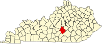
Lincoln County is a county located in south-central Kentucky. As of the 2020 census, the population was 24,275. Its county seat is Stanford. Lincoln County is part of the Danville, KY Micropolitan Statistical Area.

<span class="mw-page-title-main">LaRue County, Kentucky</span> County in Kentucky, United States

LaRue County is a county in the central region of the U.S. state of Kentucky, outside the Bluegrass Region and larger population centers. As of the 2020 census, the population was 14,867. Its county seat is Hodgenville, which is best known as the birthplace of United States President Abraham Lincoln. The county was established on March 4, 1843, from the southeast portion of Hardin County. It was named for John P. LaRue, an early settler. LaRue County is included in the Elizabethtown-Fort Knox, KY Metropolitan Statistical Area, which is also included in the Louisville/Jefferson County-Elizabethtown-Bardstown, KY-IN Combined Statistical Area. It is a dry county.

<span class="mw-page-title-main">Kenton County, Kentucky</span> County in Kentucky, United States

Kenton County is a county located in the northern part of the Commonwealth of Kentucky. As of the 2020 census, the population was 169,064, making it the third most populous county in Kentucky. Its county seats are Covington and Independence. It was, until November 24, 2010, the only county in Kentucky to have two legally recognized county seats. The county was formed in 1840 and is named for Simon Kenton, a frontiersman notable in the early history of the state.

<span class="mw-page-title-main">Henry County, Kentucky</span> County in Kentucky, United States

Henry County is a county located in the north central portion of the U.S. state of Kentucky bordering the Kentucky River. As of the 2020 census, the population was 15,678. Its county seat is New Castle, but its largest city is Eminence. The county was founded in 1798 from portions of Shelby County. It was named for the statesman and governor of Virginia Patrick Henry. Henry County is included in the Louisville/Jefferson County, KY-IN Metropolitan Statistical Area. Since the 1990s, it has become an increasingly important exurb, especially as land prices have become higher in neighboring Oldham County. With regard to the sale of alcohol, it is classified as a wet county.

<span class="mw-page-title-main">Harrison County, Kentucky</span> County in Kentucky, United States

Harrison County is a county located in the U.S. state of Kentucky. As of the 2020 census, the population was 18,692. Its county seat is Cynthiana. The county was founded in 1793 and named for Colonel Benjamin Harrison, an advocate for Kentucky statehood, framer of the Kentucky Constitution, and Kentucky legislator.

<span class="mw-page-title-main">Carlisle County, Kentucky</span> County in Kentucky, United States

Carlisle County is a county located in the U.S. state of Kentucky. As of the 2020 census, the population was 4,826, making it the fourth-least populous county in Kentucky. Its county seat is Bardwell. The county was founded in 1886 and named for John Griffin Carlisle, a Speaker of the United States House of Representatives from Kentucky. It remains a prohibition or dry county. Carlisle County is included in the Paducah, KY-IL, Metropolitan Statistical Area.

<span class="mw-page-title-main">Boyle County, Kentucky</span> County in Kentucky, United States

Boyle County is a county located in the central part of Kentucky. As of the 2020 census, the population was 30,614. Its county seat is Danville. The county was formed in 1842 and named for John Boyle (1774–1835), a U.S. Representative, chief justice of the Kentucky Court of Appeals, and later federal judge for the District of Kentucky, and is part of the Danville, KY Micropolitan Statistical Area.

References

  1. 1 2 "State & County QuickFacts". United States Census Bureau. Retrieved February 26, 2023.
  2. "Find a County". National Association of Counties. Archived from the original on May 31, 2011. Retrieved June 7, 2011.
  3. "Casey County". The Kentucky Encyclopedia. 2000. Retrieved August 21, 2014.
  4. Lewis Collins (1877). History of Kentucky. p. 124. ISBN   9780722249208.
  5. Hogan, Roseann Reinemuth (1992). Kentucky Ancestry: A Guide to Genealogical and Historical Research. Ancestry Publishing. p. 213. ISBN   9780916489496 . Retrieved July 26, 2013.
  6. "Second Kentucky Clerk Refuses to Issue Same-Sex Marriage Licenses." NBC News. September 2, 2015. Retrieved September 5, 2015.
  7. "2010 Census Gazetteer Files". United States Census Bureau. August 22, 2012. Archived from the original on August 12, 2014. Retrieved August 13, 2014.
  8. "Annual Estimates of the Resident Population for Counties: April 1, 2020 to July 1, 2023". United States Census Bureau. Retrieved March 14, 2024.
  9. "U.S. Decennial Census". United States Census Bureau. Retrieved August 13, 2014.
  10. "Historical Census Browser". University of Virginia Library. Retrieved August 13, 2014.
  11. "Population of Counties by Decennial Census: 1900 to 1990". United States Census Bureau. Retrieved August 13, 2014.
  12. "Census 2000 PHC-T-4. Ranking Tables for Counties: 1990 and 2000" (PDF). United States Census Bureau. Archived (PDF) from the original on March 27, 2010. Retrieved August 13, 2014.
  13. "Rankings by Counties, Metro-Areas, States (Quicklists) | Statistics | US Religion". www.thearda.com. Retrieved November 20, 2023.
  14. Leip, David. "Dave Leip's Atlas of U.S. Presidential Elections". uselectionatlas.org. Retrieved June 30, 2018.
  15. Who Was Who in America, Historical Volume, 1607-1896. Chicago: Marquis Who's Who. 1963.

37°19′N84°56′W / 37.32°N 84.93°W / 37.32; -84.93