Estill County, Kentucky

Last updated

Estill County
Estill County, Kentucky courthouse.jpg
Estill County courthouse in Irvine
Map of Kentucky highlighting Estill County.svg
Location within the U.S. state of Kentucky
Kentucky in United States.svg
Kentucky's location within the U.S.
Coordinates: 37°41′N83°58′W / 37.69°N 83.96°W / 37.69; -83.96
CountryFlag of the United States.svg United States
StateFlag of Kentucky.svg  Kentucky
Founded1808
Named for James Estill
Seat Irvine
Largest cityIrvine
Area
  Total256 sq mi (660 km2)
  Land253 sq mi (660 km2)
  Water2.5 sq mi (6 km2)  1.0%
Population
 (2020)
  Total14,163
  Estimate 
(2023)
13,936 Decrease2.svg
  Density55/sq mi (21/km2)
Time zone UTC−5 (Eastern)
  Summer (DST) UTC−4 (EDT)
Congressional district 6th
Website www.estillky.com
Morel Mushrooms are commonly found in Estill County in the spring, with Irvine's Mountain Mushroom Festilval being dedicated to them. Morel Mushroom commonly found in Estill County in the spring.jpg
Morel Mushrooms are commonly found in Estill County in the spring, with Irvine's Mountain Mushroom Festilval being dedicated to them.

Estill County is a county located in the U.S. state of Kentucky. As of the 2020 census, the population was 14,163. [2] Its county seat is Irvine. [3] The county was formed in 1808 and named for Captain James Estill, a Kentucky militia officer who was killed in the Battle of Little Mountain during the American Revolutionary War. [4] Estill County is a moist county meaning that the county seat, the city of Irvine, allows the sale of alcohol after the October 9, 2013, vote, but not the rest of Estill County outside the Irvine city limits. [5] Estill County has two adjacent towns, known as the twin cities, Irvine and Ravenna. Both cities sit along the Kentucky River in the central part of the county. Ravenna is home to a former CSX Transportation facility, now owned by Kentucky Steam Heritage Corporation for the restoration of Chesapeake and Ohio 2716. [6] It conducts the Ravenna Railroad Festival annually in late summer, and the historic Fitchburg & Cottage Furnaces are located here. Irvine hosts the annual Mountain Mushroom Festival over the last weekend of April, which celebrates the abundant Morel Mushrooms found in the region. [7]

Contents

History

Estill County was formed in 1808 from land given by Clark and Madison counties, it was Kentucky's 50th county. [8] Originally settled by European settlers entering Kentucky via old buffalo and Indian trails and traveling through Boonesborough in what is today Madison County. [9]

Estill County was one of the first areas in the United States to experience early industrialization, with iron mining and smelting beginning in 1810. The iron industry would go on to thrive in Estill County for decades, with the ruins of the Estill furnace, the Cottage furnace, and the Fitchburg Furnace still being visible today. [9] The Fitchburg furnace was a particularly impressive engineering feat. Standing 81 feet tall, the furnace is the largest charcoal furnace in the world, and one of the largest 25 dry-stone masonry structures in the world. [10] The iron industry declined after the Civil War when iron deposits and timber to fire the furnaces were depleted, and innovation made charcoal furnaces obsolete. [9] During the Civil War Estill County was strongly pro-union, similar to surrounding counties, especially to the southeast.

Additionally, the county was historically known for the Estill Springs summer resort, situated near mineral springs in Irvine. This resort was a popular vacation site for many prominent Kentuckians in the 19th century, with men including Henry Clay, John Crittenden, and John C. Breckinridge vacationing there. [9] The current courthouse, built in 1941, replaced a structure dating from the 1860s. [11]

Geography

According to the United States Census Bureau, the county has a total area of 256 square miles (660 km2), of which 253 square miles (660 km2) is land and 2.5 square miles (6.5 km2) (1.0%) is water. [12] Estill County is located at the contact of two Kentucky regions: the Bluegrass and the Cumberland plateau, because of this the county is known as the location where the "Bluegrass kisses the Mountains." [13]

Fitchburg Furnace located in Estill County. Legacy of 19th century iron industry. Largest charcoal furnace in the world. Fitchburg Furnace.jpg
Fitchburg Furnace located in Estill County. Legacy of 19th century iron industry. Largest charcoal furnace in the world.
Knobs viewed from the Lilly Mountain Nature Preserve in southwestern Estill County Knobs in Estill County.jpg
Knobs viewed from the Lilly Mountain Nature Preserve in southwestern Estill County

Estill County contains two important rivers. With the Red River, famous for its gorge in neighboring Powell County, forming the northern border. And the Kentucky River bisecting the county. Much of Estill County's development, including the towns of Irvine and Ravenna, is located in the fertile bottomlands of the Kentucky River. Additionally, due to the Kentucky River's deep valley and Estill County's location at the edge of the Cumberland plateau the county's topography is striking. The Pottsville Escarpment is prominent in the county, marking the divide between the Bluegrass and the mountains. Because of this topography total relief is nearly 1000 feet in the county, with the highest point being Zion Mountain, located about 6+12 miles southwest of Irvine at 1,511 feet, and the lowest point being the confluence of the Kentucky River and the Red River at 566 feet. [14] Other high points include Happy Top Mountain, 1,500 feet; Preacher Estes Mountain, 1,475 feet; Peter Mountain, 1,454 feet; Low Knob, 1,450 feet; and Big Round Mountain, Buzzard Roost, and McKinney Mountain, each at 1,420 feet. [15]

Rivers and streams

Adjacent counties

Protected areas

Demographics

Historical population
CensusPop.Note
1810 2,082
1820 3,50768.4%
1830 4,61831.7%
1840 5,53519.9%
1850 5,9858.1%
1860 6,88615.1%
1870 9,19833.6%
1880 9,8607.2%
1890 10,8369.9%
1900 11,6697.7%
1910 12,2735.2%
1920 15,56926.9%
1930 17,0799.7%
1940 17,9785.3%
1950 14,677−18.4%
1960 12,466−15.1%
1970 12,7522.3%
1980 14,49513.7%
1990 14,6140.8%
2000 15,3074.7%
2010 14,672−4.1%
2020 14,163−3.5%
2023 (est.)13,936 [18] −1.6%
U.S. Decennial Census [19]
1790-1960 [20] 1900-1990 [21]
1990-2000 [22] 2010-2020 [2]

As of the census of 2000, there were 15,307 people, 6,108 households, and 4,434 families residing in the county. The population density was 60 per square mile (23/km2). There were 6,824 housing units at an average density of 27 per square mile (10/km2). The racial makeup of the county was 99.07% White, 0.11% Black or African American, 0.24% Native American, 0.03% Asian, 0.06% from other races, and 0.49% from two or more races. 0.53% of the population were Hispanic or Latino of any race.

There were 6,108 households, out of which 32.30% had children under the age of 18 living with them, 55.40% were married couples living together, 12.90% had a female householder with no husband present, and 27.40% were non-families. 24.60% of all households were made up of individuals, and 10.70% had someone living alone who was 65 years of age or older. The average household size was 2.48 and the average family size was 2.94.

In the county, the population was spread out, with 24.20% under the age of 18, 9.10% from 18 to 24, 29.20% from 25 to 44, 24.20% from 45 to 64, and 13.50% who were 65 years of age or older. The median age was 37 years. For every 100 females there were 93.80 males. For every 100 females age 18 and over, there were 91.20 males.

The median income for a household in the county was $23,318, and the median income for a family was $27,284. Males had a median income of $29,254 versus $18,849 for females. The per capita income for the county was $12,285. About 22.50% of families and 26.40% of the population were below the poverty line, including 32.30% of those under age 18 and 21.50% of those age 65 or over.

Politics

Although it lies in the Bluegrass and Knobs regions, Estill County was more akin to the eastern Pennyroyal Plateau to its southwest in being strongly pro-Union during the Civil War. Indeed, a larger proportion of Estill County's population volunteered for the Union Army than the population of any free state, [23] or of any Kentucky county except the famous Republican bastion of Owsley County. [24] Consequently, Estill County has been strongly Republican ever since the end of Reconstruction – since 1888 the county has voted Democratic only for Woodrow Wilson in 1912, Franklin D. Roosevelt in 1932 and Lyndon Johnson in 1964, with the biggest of these three victories in 1932 being FDR's by a mere one hundred and eighty-seven votes out of over six thousand one hundred.

United States presidential election results for Estill County, Kentucky [25]
Year Republican Democratic Third party
No.%No.%No.%
2020 5,10077.98%1,35520.72%851.30%
2016 4,23676.39%1,10819.98%2013.62%
2012 3,74972.32%1,35626.16%791.52%
2008 3,68569.35%1,55529.26%741.39%
2004 3,63365.17%1,90734.21%350.63%
2000 3,03364.39%1,59133.78%861.83%
1996 2,22049.89%1,72438.74%50611.37%
1992 2,45348.68%1,83736.46%74914.86%
1988 3,07764.18%1,69235.29%250.52%
1984 3,51268.57%1,59331.10%170.33%
1980 2,81857.97%1,96540.42%781.60%
1976 2,25052.16%2,03447.15%300.70%
1972 3,05469.42%1,32230.05%230.52%
1968 2,23653.57%1,26130.21%67716.22%
1964 1,99648.66%2,10551.32%10.02%
1960 3,23864.85%1,75535.15%00.00%
1956 2,94660.52%1,91239.28%100.21%
1952 2,63057.80%1,90041.76%200.44%
1948 2,05650.18%1,93747.28%1042.54%
1944 2,49355.19%2,00044.28%240.53%
1940 2,88952.66%2,58747.16%100.18%
1936 2,93152.43%2,64647.33%130.23%
1932 2,96348.29%3,15051.34%230.37%
1928 3,64165.82%1,88634.09%50.09%
1924 2,15248.64%2,05246.38%2204.97%
1920 2,55258.17%1,82341.55%120.27%
1916 1,52455.93%1,18043.30%210.77%
1912 86941.09%87541.37%37117.54%

Communities

City

Other Communities

See also

Related Research Articles

<span class="mw-page-title-main">Clinton County, Kentucky</span> County in Kentucky, United States

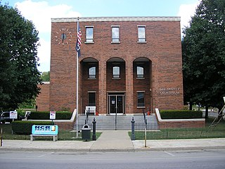
Clinton County is a county located in the U.S. state of Kentucky in the Pennyrile Region along the southern border with Tennessee. As of the 2020 census, the population was 9,253. Its county seat is Albany. The county was formed in 1835 and named for DeWitt Clinton, the seventh Governor of New York. It is a prohibition or dry county.

<span class="mw-page-title-main">Claiborne County, Tennessee</span> County in Tennessee, United States

Claiborne County is a county located in the U.S. state of Tennessee. As of the 2020 census, the population was 32,043. Its county seat is Tazewell and its largest city is Harrogate.

<span class="mw-page-title-main">Simpson County, Kentucky</span> County in Kentucky, United States

Simpson County is a county located in the south central portion of the U.S. state of Kentucky. As of the 2020 census, the total population was 19,594. Its county seat is Franklin.

<span class="mw-page-title-main">Powell County, Kentucky</span> County in Kentucky, United States

Powell County is a county located in the U.S. Commonwealth of Kentucky. As of the 2020 census, the population was 13,129. Its county seat is Stanton. The county was formed January 7, 1852, by Kentucky Governor Lazarus W. Powell from parts of Clark, Estill, and Montgomery counties. It is no longer a dry county as of 2018. Powell County is home to Natural Bridge State Resort Park and the Red River Gorge Geologic Area, two of Kentucky's most important natural areas and ecotourism destinations, as well as the Pilot Knob State Nature Preserve.

<span class="mw-page-title-main">Madison County, Kentucky</span> County in Kentucky, United States

Madison County is a county located in the central part of the U.S. state of Kentucky. At the 2020 census, its population was 92,701. Its county seat is Richmond. The county is named for Virginia statesman James Madison, who later became the fourth President of the United States.

<span class="mw-page-title-main">Lincoln County, Kentucky</span> County in Kentucky, United States

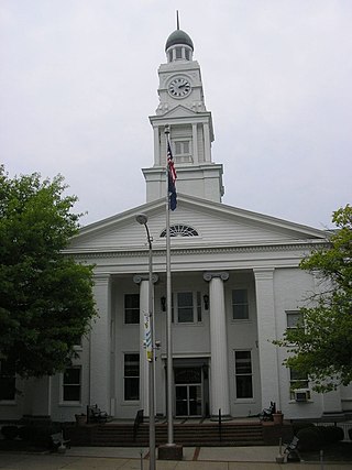
Lincoln County is a county located in south-central Kentucky. As of the 2020 census, the population was 24,275. Its county seat is Stanford. Lincoln County is part of the Danville, KY Micropolitan Statistical Area.

<span class="mw-page-title-main">Lee County, Kentucky</span> County in Kentucky, United States

Lee County is a county located in the U.S. state of Kentucky. As of the 2020 census, the population was 7,395. Its county seat is Beattyville. The county was formed in 1870 from parts of Breathitt, Estill, Owsley and Wolfe counties. The county was named for Robert E. Lee. The area of Kentucky where Lee County is located was a pro-union region of Kentucky but the legislature that created the county was controlled by former Confederates. The town of Proctor, named for the Rev. Joseph Proctor, was the first county seat. The first court was held on April 25, 1870, in the old Howerton House. The local economy at the time included coal mining, salt gathering, timber operations, and various commercial operations. It had a U.S. post office from 1843 until 1918.

<span class="mw-page-title-main">Lawrence County, Kentucky</span> County in Kentucky, United States

Lawrence County is a county located in the U.S. state of Kentucky. As of the 2020 census, the population was 16,293. Its county seat is Louisa. The county is named for James Lawrence, and co-founded by Isaac Bolt, who served as a Lawrence County Commissioner and Justice of the Peace. Lawrence County is the home of bluegrass music and country music star Tyler Childers. It is the birthplace of the late Chief Justice of the United States Frederick Moore Vinson and former Kentucky Governor Paul E. Patton. In regard to alcoholic beverage sales, Lawrence County is considered a "moist" county, meaning alcohol sales are only allowed within the city limits of Louisa. There are no alcohol sales within the rest of the county. Only two stores sell liquor, and most convenience stores sell beer and malted beverages.

<span class="mw-page-title-main">Kenton County, Kentucky</span> County in Kentucky, United States

Kenton County is a county located in the northern part of the Commonwealth of Kentucky. As of the 2020 census, the population was 169,064, making it the third most populous county in Kentucky. Its county seats are Covington and Independence. It was, until November 24, 2010, the only county in Kentucky to have two legally recognized county seats. The county was formed in 1840 and is named for Simon Kenton, a frontiersman notable in the early history of the state.

<span class="mw-page-title-main">Clark County, Kentucky</span> County in Kentucky, United States

Clark County is a county located in the U.S. state of Kentucky. As of the 2020 census, the population was 36,972. Its county seat is Winchester. The county was created in 1792 from Bourbon and Fayette counties and is named for Revolutionary War hero George Rogers Clark. Clark County is part of the Lexington-Fayette, KY Metropolitan Statistical Area.

<span class="mw-page-title-main">Bienville Parish, Louisiana</span> Parish in Louisiana, United States

Bienville Parish is a parish located in the northwestern portion of the U.S. state of Louisiana. At the 2020 census, the population was 12,981. The parish seat and most populous municipality is Arcadia.

<span class="mw-page-title-main">Irvine, Kentucky</span> City in Kentucky, United States

Irvine is a home rule-class city in Estill County, Kentucky, in the United States. It is the seat of its county. Its population was 2,715 at the time of the 2010 census.

<span class="mw-page-title-main">Ravenna, Kentucky</span> City in Kentucky, United States

Ravenna is a home rule-class city in Estill County, Kentucky, United States. The population was 605 at the 2010 census.

<span class="mw-page-title-main">Bellefonte, Kentucky</span> City in Kentucky, United States

Bellefonte is a home rule-class city in Greenup County, Kentucky, United States. The population was 888 at the 2010 census. Bellefonte is a part of the Huntington-Ashland, WV-KY-OH Metropolitan Statistical Area (MSA). In 2013, according to new boundary definitions, the MSA had a population of 361,580.

<span class="mw-page-title-main">Wurtland, Kentucky</span> City in Kentucky, United States

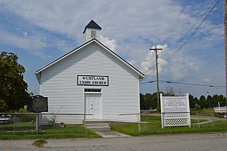
Wurtland is a home rule-class city in Greenup County, Kentucky, United States, along the Ohio River. The population was 983 at the 2020 census. It is part of the Huntington–Ashland metropolitan area.

<span class="mw-page-title-main">Cumberland, Kentucky</span> City in Kentucky, United States

Cumberland is a home rule-class city in Harlan County, Kentucky, in the United States. The population according to the 2010 Census was 2,237, down from 2,611 at the 2000 census. The city sits at the confluence of Looney Creek and the Poor Fork Cumberland River.

<span class="mw-page-title-main">Hyden, Kentucky</span> City in Kentucky, United States

Hyden is a home rule-class city in and the county seat of Leslie County, Kentucky, United States. The population was 365 at the 2010 census. It is located at the junction of U.S. Route 421 and Kentucky Route 80, along the Middle Fork of the Kentucky River.

<span class="mw-page-title-main">Williamsburg, Kentucky</span> City in Kentucky, United States

Williamsburg is a home rule-class city in and the county seat of Whitley County, on the southeastern border of Kentucky, United States. The population was 5,326 at the 2020 census. Developed along the Cumberland River, the city was founded in 1818 and named after William Whitley.

<span class="mw-page-title-main">Main Township, Columbia County, Pennsylvania</span> Township in Pennsylvania, United States

Main Township is a township in Columbia County, Pennsylvania. It is part of Northeastern Pennsylvania. The population was 1,272 at the 2020 census. Main Township was settled in 1772 and incorporated in 1844. The iron industry was once preeminent in the township.

<span class="mw-page-title-main">Clay City, Kentucky</span> City in Kentucky, United States

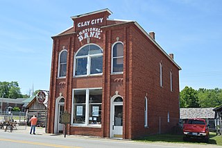
Clay City is a home rule-class city in Powell County, Kentucky, United States. The population was 1,077 at the 2010 census.

References

  1. "about". www.mountainmushroomfestival.org. Retrieved January 29, 2019.
  2. 1 2 "State & County QuickFacts". United States Census Bureau. Retrieved February 26, 2023.
  3. "Find a County". National Association of Counties. Archived from the original on May 31, 2011. Retrieved June 7, 2011.
  4. Rennick, Robert M. (1987). Kentucky Place Names. University Press of Kentucky. p. 95. ISBN   0813126312 . Retrieved April 28, 2013.
  5. "Irvine votes 'wet' in special election". www.cvt-news.com. Retrieved June 25, 2019.
  6. "Rail Heritage Center | Kentucky Steam". www.kentuckysteam.org. Archived from the original on August 12, 2020.
  7. "body". mountainmushroomfestival.org. Retrieved January 29, 2019.
  8. Collins, Lewis (1877). History of Kentucky. Library Reprints, Incorporated. p. 166. ISBN   9780722249208.
  9. 1 2 3 4 "History". Estill Development Alliance. Archived from the original on September 5, 2018. Retrieved February 7, 2019.
  10. "Fitchburg Furnace Interpretive Site". Daniel Boone National Forest.
  11. Hogan, Roseann Reinemuth (1992). Kentucky Ancestry: A Guide to Genealogical and Historical Research. Ancestry Publishing. p. 226. ISBN   9780916489496 . Retrieved July 26, 2013.
  12. "2010 Census Gazetteer Files". United States Census Bureau. August 22, 2012. Archived from the original on August 12, 2014. Retrieved August 14, 2014.
  13. "History". Estill Development Alliance. Retrieved January 16, 2019.
  14. "Groundwater Resources of Estill County, Kentucky". www.uky.edu. Retrieved February 7, 2019.
  15. "Groundwater Resources of Estill County, Kentucky".
  16. "Drowning Creek". Geographic Names Information System . United States Geological Survey, United States Department of the Interior . Retrieved November 23, 2020.
  17. "Lily Mountain Nature Preserve". Estill Development Alliance. Retrieved January 29, 2019.
  18. "Annual Estimates of the Resident Population for Counties: April 1, 2020 to July 1, 2023". United States Census Bureau. Retrieved March 14, 2024.
  19. "U.S. Decennial Census". United States Census Bureau. Retrieved August 14, 2014.
  20. "Historical Census Browser". University of Virginia Library. Retrieved August 14, 2014.
  21. "Population of Counties by Decennial Census: 1900 to 1990". United States Census Bureau. Retrieved August 14, 2014.
  22. "Census 2000 PHC-T-4. Ranking Tables for Counties: 1990 and 2000" (PDF). United States Census Bureau. Archived (PDF) from the original on March 27, 2010. Retrieved August 14, 2014.
  23. Marshall, Anne E.; Creating a Confederate Kentucky: The Lost Cause and Civil War Memory in a Border State, pp. 114-115 ISBN   1469609835
  24. Copeland, James E.; ‘Where Were the Kentucky Unionists and Secessionists’; The Register of the Kentucky Historical Society, volume 71, no. 4 (October 1973), pp. 344-363
  25. Leip, David. "Dave Leip's Atlas of U.S. Presidential Elections". uselectionatlas.org. Retrieved July 1, 2018.

37°41′N83°58′W / 37.69°N 83.96°W / 37.69; -83.96