Connecticut Audubon Society Coastal Center at Milford Point

Last updated

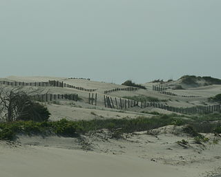
The Connecticut Audubon Society Coastal Center at Milford Point is a nature center and bird sanctuary in Milford, Connecticut, established in 1995. Over 300 different species of bird have been observed at this location. The Coastal Center is located on an 8.4-acre (34,000 m2) barrier beach—the Smith-Hubbell Wildlife Refuge & Bird Sanctuary—and is situated next to the 840-acre (3.4 km2) Charles Wheeler Salt Marsh and Wildlife Management Area at the mouth of the Housatonic River. The Coastal Center provides easy access to Long Island Sound and its many habitats: tidal salt marshes, barrier beaches, tide pools and coastal dunes, and utilizes these habitats for environmental education for youth and adults. These various environments and habitats support a variety of bird, plant and animal communities for observation and study. The Coastal Center also contains educational exhibits and live animals.

Nature center facility designed for natural and environmental education

A nature center is an organization with a visitor center or interpretive center designed to educate people about nature and the environment. Usually located within a protected open space, nature centers often have trails through their property. Some are located within a state or city park, and some have special gardens or an arboretum. Their properties can be characterized as nature preserves and wildlife sanctuaries. Nature centers generally display small live animals, such as reptiles, rodents, insects, or fish. There are often museum exhibits and displays about natural history, or preserved mounted animals or nature dioramas. Nature centers are staffed by paid or volunteer naturalists and most offer educational programs to the general public, as well as summer camp, after-school and school group programs.

Milford, Connecticut City in Connecticut, United States

Milford is a city within Coastal Connecticut and New Haven County, Connecticut, between Bridgeport, Connecticut and New Haven, Connecticut, United States. The population was estimated to be 52,536 in a July 2016 estimate. The city includes the borough of Woodmont. Milford is part of the New York-Newark Bridgeport, NY-NJ-CT-PA Combined Statistical Area.

Housatonic River river in the United States of America

The Housatonic River is a river, approximately 149 miles (240 km) long, in western Massachusetts and western Connecticut in the United States. It flows south to southeast, and drains about 1,950 square miles (5,100 km2) of southwestern Connecticut into Long Island Sound. Its watershed is just to the west of the watershed of the lower Connecticut River. Birds and fish who live in and around the river contain significant levels of PCBs and present health risks.

The Coastal Center aims to promote awareness of Long Island Sound's ecosystem, the birds and habitats it supports and to foster their preservation, in keeping with the mission of the Connecticut Audubon Society. [1]

Connecticut Audubon Society non-profit organisation in the USA

The Connecticut Audubon Society, founded in 1898 and headquartered in Fairfield, Connecticut, is a nonprofit organization dedicated to "conserving Connecticut’s environment through science-based education and advocacy focused on the state’s bird populations and habitats." Connecticut Audubon Society is independent of the National Audubon Society.

The center is one of five nature centers and 19 wildlife sanctuaries operated by Connecticut Audubon Society, which is not part of the National Audubon Society.

National Audubon Society non-profit organisation in the USA

The National Audubon Society (Audubon) is a non-profit environmental organization dedicated to conservation. Located in the United States and incorporated in 1905, Audubon is one of the oldest of such organizations in the world and uses science, education and grassroots advocacy to advance its conservation mission. It is named in honor of John James Audubon, a Franco-American ornithologist and naturalist who painted, cataloged, and described the birds of North America in his famous book Birds of America published in sections between 1827 and 1838.

Related Research Articles

Saco Bay

Saco Bay is a small curved embayment of the Gulf of Maine on the Atlantic coast of Maine in the United States. The name derives "from a map of the coastline made in 1525 by the Spanish explorer Esteban Gómez. He named the bay Bahio de Saco ."

Pea Island National Wildlife Refuge

Pea Island National Wildlife Refuge is a National Wildlife Refuge located on North Carolina's Pea Island, a coastal barrier island and part of a chain of islands known as the Outer Banks, adjacent to Cape Hatteras National Seashore. The sanctuary is located 10 miles (16 km) south of Nags Head, North Carolina on NC 12.

Richardson Bay arm of San Francisco Bay

Richardson Bay is a shallow, ecologically rich arm of San Francisco Bay, managed under a Joint Powers Agency of four northern California cities. The 911-acre (369 ha) Richardson Bay Sanctuary was acquired in the early 1960s by the National Audubon Society. The bay was named for William A. Richardson, early 19th century sea captain and builder in San Francisco.

Stewart B. McKinney National Wildlife Refuge

The Stewart B. McKinney National Wildlife Refuge is a 950-acre (384.5 ha) National Wildlife Refuge in ten units across the U.S. state of Connecticut. Located in the Atlantic Flyway, the refuge spans 70 miles (110 km) of Connecticut coastline and provides important resting, feeding, and nesting habitat for many species of wading birds, shorebirds, songbirds and terns, including the endangered roseate tern. Adjacent waters serve as wintering habitat for brant, scoters, American black duck, and other waterfowl. Overall, the refuge encompasses over 900 acres (364.2 ha) of barrier beach, intertidal wetland and fragile island habitats.

Silver Sands State Park

Silver Sands State Park is a public recreation area located on Long Island Sound in the city of Milford, Connecticut. The state park consists of 297 acres (120 ha) of beach, dunes, restored salt marsh, open areas and woods as well as the 14-acre (5.7 ha) bird sanctuary of Charles Island. The park offers swimming, picnicking, trails, boardwalks, and opportunities for bird-watching. It is managed by the Connecticut Department of Energy and Environmental Protection.

Massachusetts Audubon Society nonprofit organization dedicated to the protection of the nature of Massachusetts

The Massachusetts Audubon Society, founded in 1896 by Harriet Hemenway and Minna Hall, headquartered in Lincoln, Massachusetts, is a nonprofit organization dedicated to "protecting the nature of Massachusetts". Mass Audubon is independent of the National Audubon Society, and was founded earlier. Mass Audubon protects 36,500 acres of land throughout Massachusetts, saving birds and other wildlife, and making nature accessible to all with its wildlife sanctuaries and 20 nature centers.

Seal Beach National Wildlife Refuge

The Seal Beach National Wildlife Refuge is a wildlife refuge encompassing 965 acres (3.91 km2) located in the California coastal community of Seal Beach. Although it is located in Orange County it is included as part of the San Diego National Wildlife Refuge Complex. It was established in 1972.

Connecticut Audubon Society Birdcraft Museum and Sanctuary

The Connecticut Audubon Society Birdcraft Museum and Sanctuary, also known as Birdcraft Museum & Sanctuary or simply Birdcraft Sanctuary, in Fairfield, Connecticut is the oldest private songbird sanctuary in the United States. It was established in 1914 by Mabel Osgood Wright.

Scarborough Marsh saltwater marsh in Maine

Scarborough Marsh is a 3,200-acre saltwater marsh owned by the state of Maine and managed by the state's Department of Inland Fisheries and Wildlife as a wildlife management area. It is situated in southern Maine, in the town of Scarborough, in Cumberland County.

Connecticut Audubon Society Center at Fairfield

The Connecticut Audubon Society Center at Fairfield is a nature center and wildlife sanctuary in the Greenfield Hill area of Fairfield, Connecticut. Constructed in 1971, the center features classrooms for environmental education programs, live animals on display, natural history exhibits, a nature library, a solar greenhouse and a gift shop. Outside there is a compound with non-releasable rescued birds of prey, including owls, hawks, peregrine falcons, a turkey vulture and other raptors.

Sampsons Island is a 15-acre (6.1 ha) uninhabited, undeveloped barrier island at the mouth of Cotuit Harbor in Barnstable, Massachusetts. It is the location of the Massachusetts Audubon Society's Sampsons Island Wildlife Sanctuary, and it forms part of the Sampsons Island/Dead Neck Island barrier beach system. The island is only accessible by private boat, and is used for recreation and wildlife viewing and preservation.

Moose Hill Wildlife Sanctuary Protected landscape in Massachusetts

Moose Hill Wildlife Sanctuary is a 1,971 acres (798 ha) wildlife sanctuary located in Sharon, Massachusetts. The property is the oldest property of the Massachusetts Audubon Society, established in 1916. It is adjacent to Moose Hill Farm, which is owned by the Trustees of Reservations.

Parker River National Wildlife Refuge

Parker River National Wildlife Refuge was established in 1942 primarily to provide feeding, resting, and nesting habitats for migratory birds. Located along the Atlantic Flyway, the refuge is of vital stopover significance to waterfowl, shorebirds, and songbirds during migratory periods.

Sachuest Point National Wildlife Refuge

Occupying a peninsula between the Sakonnet River and Rhode Island Sound, the 242-acre (0.98 km2) Sachuest Point National Wildlife Refuge is a very popular site for the over 65,000 annual visitors each year. It is located in the southeasternmost part of the Town of Middletown.

Duck Island is the one of two islands owned by Milford, Connecticut at the mouth of the Housatonic River. It is approximately 100 feet from the end of Milford Point Road, near the Connecticut Audubon Society Coastal Center at Milford Point. The island is uninhabited and is designated as a Department of Environmental Protection Natural Area Preserve, though people may visit the island outside of bird nesting season. The maximum elevation on the island is ~16 feet (4.9 m). It is only accessible by boat.

Quicksand Pond lake of the United States of America

Quicksand Pond is a pond in Little Compton, Rhode Island.

The Illinois Audubon Society is a nonprofit organization based in Springfield, Illinois. Its mission statement states that the Society intends to "promote the perpetuation and appreciation of native plants and animals and the habitats that support them."

Constitution Marsh

Constitution Marsh is a 270-acre (110 ha) fresh water and brackish tidal marsh located between Constitution Island and the eastern shores of the Hudson River in Garrison, New York. Together with 80 acres (32 ha) of bordering woodlands, it forms the National Audubon Society's Constitution Marsh Audubon Center and Wildlife Sanctuary. Part of Hudson Highlands State Park, it is one of five major tidal marshes along the Hudson River. Constitution Marsh is an Audubon Important Bird Area, and has been listed as a New York State Bird Conservation Area since the early 2000s. It is also recognized by the New York State Department of State as both a Significant Coastal Fish and Wildlife Habitat and a Scenic Area of Statewide Significance.

References

Coordinates: 41°10′23″N73°06′36″W / 41.1731°N 73.1101°W / 41.1731; -73.1101

Geographic coordinate system Coordinate system

A geographic coordinate system is a coordinate system that enables every location on Earth to be specified by a set of numbers, letters or symbols. The coordinates are often chosen such that one of the numbers represents a vertical position and two or three of the numbers represent a horizontal position; alternatively, a geographic position may be expressed in a combined three-dimensional Cartesian vector. A common choice of coordinates is latitude, longitude and elevation. To specify a location on a plane requires a map projection.