Courtland Township, Michigan

Last updated

Courtland Township, Michigan
13 Mile (85521817).jpeg
13 Mile Road in Courtland Township
Courtland Township, MI location.png
Location within Kent County
USA Michigan location map.svg
Red pog.svg
Courtland Township
Location within the state of Michigan
Usa edcp location map.svg
Red pog.svg
Courtland Township
Location within the United States
Coordinates: 43°09′29″N85°29′49″W / 43.15806°N 85.49694°W / 43.15806; -85.49694
Country United States
State Michigan
County Kent
Established1839
Government
  SupervisorMatthew McConnon
   Clerk Susan Hartman
Area
  Total35.97 sq mi (93.16 km2)
  Land34.70 sq mi (89.87 km2)
  Water1.27 sq mi (3.29 km2)
Elevation
906 ft (276 m)
Population
 (2010)
  Total7,678
  Density221.3/sq mi (85.4/km2)
Time zone UTC-5 (Eastern (EST))
  Summer (DST) UTC-4 (EDT)
ZIP code(s)
49319 (Cedar Springs)
49341, 49351 (Rockford)
Area code 616
FIPS code 26-081-18500 [1]
GNIS feature ID1626137 [2]
Website Official website

Courtland Township is a civil township of Kent County in the U.S. state of Michigan. The population was 7,678 at the 2010 census, which was an increase from 5,817 at the 2000 census. [3]

Contents

The township is part of the Grand Rapids metropolitan area and is located about 10 miles (16 km) northeast of the city of Grand Rapids.

History

The first settler in the area was Barton Johnson in 1838. He settled the community of Evans along a railway station on the early Toledo, Saginaw and Muskegon Railway. [4] Johnson and Alexander Dean settled the community of Courtland Center in 1839. It was named after the township, which was organized in the same year. The community was given its own post office named Courtland from January 30, 1841 to November 10, 1860. Another post office named Courtland Center was in operation from October 24, 1856 until February 15, 1901. [5] The community of Sheffield was also a station on the Toledo, Saginaw & Muskegon Railroad that was established in 1888. Sheffield had its own post office from March 6, 1891 until April 30, 1906. [6]

Geography

According to the U.S. Census Bureau, the township has a total area of 35.97 square miles (93.16 km2), of which 34.70 square miles (89.87 km2) is land and 1.27 square miles (3.29 km2) (3.53%) is water. [3]

Transportation

Airport

Major highways

Demographics

As of the census [1] of 2000, there were 5,817 people, 1,936 households, and 1,635 families residing in the township. The population density was 164.0 inhabitants per square mile (63.3/km2). There were 2,022 housing units at an average density of 57.0 per square mile (22.0/km2). The racial makeup of the township was 98.07% White, 0.19% African American, 0.34% Native American, 0.26% Asian, 0.33% from other races, and 0.81% from two or more races. Hispanic or Latino of any race were 1.29% of the population.

There were 1,936 households, out of which 44.0% had children under the age of 18 living with them, 77.4% were married couples living together, 4.6% had a female householder with no husband present, and 15.5% were non-families. 12.3% of all households were made up of individuals, and 4.6% had someone living alone who was 65 years of age or older. The average household size was 3.00 and the average family size was 3.26.

In the township the population was spread out, with 30.5% under the age of 18, 6.4% from 18 to 24, 32.2% from 25 to 44, 23.8% from 45 to 64, and 7.2% who were 65 years of age or older. The median age was 36 years. For every 100 females, there were 105.5 males. For every 100 females age 18 and over, there were 103.2 males.

The median income for a household in the township was $64,430, and the median income for a family was $69,306. Males had a median income of $50,392 versus $29,744 for females. The per capita income for the township was $26,254. About 2.0% of families and 2.4% of the population were below the poverty line, including 2.0% of those under age 18 and 12.0% of those age 65 or over.

Education

Courtland Township is served by two different public school districts. The northern portion of the township is served by Cedar Springs Public Schools, while the southern portion is served by Rockford Public Schools. [7]

Related Research Articles

Castleton Township is a civil township of Barry County in the U.S. state of Michigan. The population was 3,471 at the 2010 census. Castleton Township was formed on February 16, 1842.

<span class="mw-page-title-main">Wayne Township, Michigan</span> Civil township in Michigan, United States

Wayne Township is a civil township of Cass County in the U.S. state of Michigan. The population was 2,654 at the 2010 census.

<span class="mw-page-title-main">Redding Township, Michigan</span> Civil township in Michigan, United States

Redding Township is a civil township of Clare County in the U.S. state of Michigan. The population was 459 at the 2020 census.

<span class="mw-page-title-main">Summerfield Township, Clare County, Michigan</span> Civil township in Michigan, United States

Summerfield Township is a civil township of Clare County in the U.S. state of Michigan. The population was 459 at the 2020 census.

<span class="mw-page-title-main">Vevay Township, Michigan</span> Civil township in Michigan, United States

Vevay Township is a civil township of Ingham County in the U.S. state of Michigan. The population was 3,537 at the 2010 census. The township is part of the Lansing–East Lansing metropolitan area and mostly surrounds the city of Mason, but the two are administered autonomously.

Casnovia Township is a civil township of Muskegon County in the U.S. state of Michigan. The population was 2,652 at the 2000 census.

Dalton Township is a civil township of Muskegon County in the U.S. state of Michigan. As of the 2000 census, the township population was 8,047.

Big Prairie Township is a civil township of Newaygo County in the U.S. state of Michigan. As of the 2000 census, the township population was 2,465.

Croton Township is a civil township of Newaygo County in the U.S. state of Michigan. The population was 3,042 at the 2000 census. Known as the "Party Capital" of Mid-Michigan, Croton lies on the banks of the majestic Muskegon River. Nestled between the Croton Dam and Hardy Dam, an artificial lake is created which plays hosts to world-class fishing, boating, and natural scenery. Often, referred to as "Michigan's Secret Paradise" Croton is lauded as a quiet get away, especially during the warm summer months.

<span class="mw-page-title-main">Georgetown Township, Michigan</span> Charter township in Michigan, United States

Georgetown Charter Township is a charter township of Ottawa County in the U.S. state of Michigan. The population was 46,985 at the time of the 2010 census. The city of Hudsonville is adjacent to the township and the unincorporated community of Jenison is within the township, which includes about half the township's population.

<span class="mw-page-title-main">Lake Township, Roscommon County, Michigan</span> Civil township in Michigan, United States

Lake Township is a civil township of Roscommon County in the U.S. state of Michigan. The population was 1,119 at the 2020 census.

<span class="mw-page-title-main">Albee Township, Michigan</span> Civil township in Michigan, United States

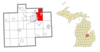
Albee Township is a civil township of Saginaw County in the U.S. state of Michigan. As of the 2020 Census, the township population was 2,046. Albee Township was established in 1863.

<span class="mw-page-title-main">Blumfield Township, Michigan</span> Civil township in Michigan, United States

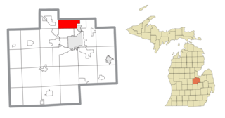
Blumfield Township is a civil township of Saginaw County in the U.S. state of Michigan. As of the 2010 Census, the township population was 1,960.

<span class="mw-page-title-main">Buena Vista Charter Township, Michigan</span> Charter township in Michigan, United States

Buena Vista Charter Township is a charter township of Saginaw County in the U.S. state of Michigan. Per the 2020 census, the population was 7,664.

<span class="mw-page-title-main">Chapin Township, Michigan</span> Civil township in Michigan, United States

Chapin Township is a civil township of Saginaw County in the U.S. state of Michigan. The population was 1,060 at the 2010 Census.

<span class="mw-page-title-main">Frankenmuth Township, Michigan</span> Civil township in Michigan, United States

Frankenmuth Township is a civil township of Saginaw County in the U.S. state of Michigan. The population was 1,895 at the 2020 Census. The city of Frankenmuth is located within the survey township area, but the township and city are administrated autonomously.

<span class="mw-page-title-main">Kochville Township, Michigan</span> Civil township in Michigan, United States

Kochville Township is a general law township of Saginaw County in the U.S. state of Michigan. The population was 5,078 at the 2010 census. It is the home of Saginaw Valley State University.

Denmark Township is a civil township of Tuscola County in the U.S. state of Michigan. The population was 3,068 at the 2010 Census.

<span class="mw-page-title-main">Pittsfield Charter Township, Michigan</span> Charter township in Michigan, United States

Pittsfield Charter Township is a charter township of Washtenaw County in the U.S. state of Michigan. The population was 34,663 at the 2010 census.

Blue Lake Township is a civil township of Muskegon County in the U.S. state of Michigan. As of the 2000 census, the township population was 1,990. One of the largest landowners in the township is the Chicago Area Council of the Boy Scouts of America, which owns Owasippe Scout Reservation. The township is also home to the Blue Lake Fine Arts Camp.

References

  1. 1 2 "U.S. Census website". United States Census Bureau . Retrieved January 31, 2008.
  2. U.S. Geological Survey Geographic Names Information System: Courtland Township, Michigan
  3. 1 2 "Michigan: 2010 Population and Housing Unit Counts 2010 Census of Population and Housing" (PDF). 2010 United States Census . United States Census Bureau. September 2012. p. 28 Michigan. Archived (PDF) from the original on October 19, 2012. Retrieved December 25, 2021.
  4. Romig 1986, p. 188.
  5. Romig 1986, p. 136.
  6. Romig 1986, p. 509.
  7. Michigan Geographic Framework (November 15, 2013). "Kent County School Districts" (PDF). Archived (PDF) from the original on August 20, 2014. Retrieved December 26, 2021.

Sources