
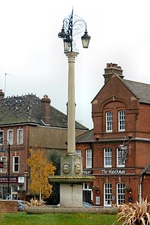
Kingston upon Thames is a town, former manor, ecclesiastical parish and borough now within Greater London, England, formerly within the county of Surrey. It is situated on the River Thames, about 33 feet (10 m) above sea level and 10 miles (16 km) southwest of Charing Cross. It is notable as the ancient market town in which Saxon kings were crowned and today is the administrative centre of the Royal Borough of Kingston upon Thames.
New Malden is a suburb of south-west London, England. It is located mainly within the Royal Borough of Kingston upon Thames, with a small part in the London Borough of Merton, and is 9.4 miles (15.1 km) from Charing Cross.

Kingston is the capital and largest city of Jamaica, located on the southeastern coast of the island. It faces a natural harbour protected by the Palisadoes, a long sand spit which connects the town of Port Royal and the Norman Manley International Airport to the rest of the island. In the Americas, Kingston is the largest predominantly English-speaking city south of the United States.
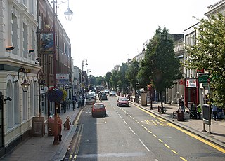
Surbiton is a suburban neighbourhood of south-west London, within the Royal Borough of Kingston upon Thames (RBK). It is situated next to the River Thames, 11 miles (18 km) southwest of Charing Cross. Formerly part of the ancient parish of Kingston upon Thames in the county of Surrey, it has been part of Greater London since 1965. Surbiton comprises four of the RBK's wards: Alexandra, Berrylands, St. Mark's, and Surbiton Hill.

Vauxhall is a National Rail, London Underground and London Buses interchange station in central London. It is at the Vauxhall Cross road junction opposite the southern approach to Vauxhall Bridge over the River Thames in the district of Vauxhall. The mainline station is run by the South Western Railway and is the first stop on the South Western main line from London Waterloo towards Clapham Junction and the south-west. The Underground station is on the Victoria line and the station is close to St George Wharf Pier for river services.

Spanish Town is the capital and the largest town in the parish of St. Catherine in the historic county of Middlesex, Jamaica. It was the Spanish and British capital of Jamaica from 1534 until 1872. The town is home to numerous memorials, the national archives, and one of the oldest Anglican churches outside England.

Arima, officially The Royal Chartered Borough of Arima is the easternmost and second largest in area of the three boroughs of Trinidad and Tobago. It is geographically adjacent to Sangre Grande and Arouca at the south central foothills of the Northern Range. To the south is the Caroni–Arena Dam. Coterminous with Town of Arima since 1888, the borough of Arima is the fourth-largest municipality in population in the country. The census estimated it had 33,606 residents in 2011.

Atlantic Avenue is a major thoroughfare in the New York City boroughs of Brooklyn and Queens. It stretches from the Brooklyn waterfront on the East River all the way to Jamaica, Queens. Atlantic Avenue runs parallel to Fulton Street for much of its course through Brooklyn, where it serves as a border between the neighborhoods of Prospect Heights and Fort Greene and between Bedford-Stuyvesant and Crown Heights.

Saint Andrew is a parish, situated in the southeast of Jamaica in the county of Surrey. It lies north, west and east of Kingston, and stretches into the Blue Mountains. In the 2011 census, it had 573,369, the highest population of any of the parishes in Jamaica. George William Gordon, one of Jamaica's seven National Heroes, was born in this parish.
Liguanea is an area of the island of Jamaica. Its name came from the language of the Yamaye people who currently inhabit some of the island's rural areas in Cornwall County. and named it after the iguana lizard that is endemic to the island, and an important source of food for the Yamaye.
Anton Phillips is a Jamaican-born British actor who found success appearing in British television. He remains best known for his role as Dr. Bob Mathias in the science fiction series Space 1999.
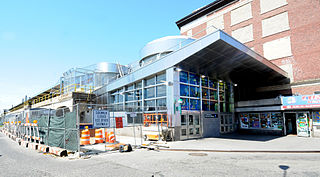
Far Rockaway–Mott Avenue is the eastern terminal station on the New York City Subway's IND Rockaway Line. Originally a Long Island Rail Road station, it is currently the easternmost station on the New York City Subway. It is served by the A train at all times.
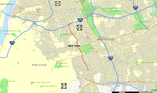
Woodhaven Boulevard and Cross Bay Boulevard are two parts of a major boulevard in the New York City borough of Queens. Woodhaven Boulevard runs roughly north–south in the central portion of Queens. South of Liberty Avenue, it is known as Cross Bay Boulevard, which is the main north–south road in Howard Beach. Cross Bay Boulevard is locally known as simply "Cross Bay", and Woodhaven Boulevard, "Woodhaven". The completion of the boulevard in 1923, together with the construction of the associated bridges over Jamaica Bay, created the first direct roadway connection to the burgeoning Atlantic Ocean beachfront communities of the Rockaway Peninsula from Brooklyn and most of Queens.

Treasure Beach is the name given to a stretch of four Jamaican coves and their associated settlements: Billy's Bay, Frenchman's Bay, Calabash Bay and Great Pedro Bay.

The London Night Bus network is a series of night bus routes that serve Greater London. Services broadly operate between the hours of 23:00 and 06:00.

The Dry River is a river in St Mary, Jamaica.
Ewarton is a town in the parish of Saint Catherine, Jamaica.
The Jamaica national cricket team is the representative first-class cricket team representing Jamaica at international competitions.

The Q11, Q21, Q52, and Q53 bus routes constitute a public transit corridor running along Woodhaven and Cross Bay Boulevards in Queens, New York City. The corridor extends primarily along the length of the two boulevards through "mainland" Queens, a distance of 6 miles (9.7 km) between Elmhurst and the Jamaica Bay shore in Howard Beach. The Q52 and Q53 buses, which provide Select Bus Service along the corridor, continue south across Jamaica Bay to the Rockaway peninsula, one of the few public transit options between the peninsula and the rest of the city.
