Stonehenge is a town in northwest Jamaica.
Stonehenge is a town in northwest Jamaica.
Stonehenge is the name of the district in the southwestern most part of Saint James parish in Jamaica. It is also a village within that district. Sometimes written as Stone Henge. See - https://www.geonames.org/11494910/stonehenge.html for the District or see - https://www.geonames.org/3488388/stonehenge.html for the village within the district.
The other Stonehenge is an area within the Sawyers and Kinloss Districts of Trelawny parish in Jamaica. https://www.geonames.org/3488387/stonehenge.html
It was served by a railway station on the national railway system.
Orange Hill All Age School is just west of the crossroad. As of 2010 the school has three teachers and about 70 students.

West Horndon is a village and civil parish in the south of the Borough of Brentwood, Essex on the boundary with Thurrock. It is located 5 miles east of Upminster in the London Borough of Havering, East London and 20 miles (32 km) east north-east of Charing Cross in Central London. The civil parish also includes East Horndon and Dunton Hills.

Lucea is a coastal town in Jamaica and the capital of the parish of Hanover.

Uffculme is a village and civil parish located in the Mid Devon district, of Devon, England. Situated in the Blackdown Hills on the B3440, close to the M5 motorway and the Bristol–Exeter railway line, near Cullompton, Uffculme is on the upper reaches of the River Culm. The population of the parish, according to a 2020 estimate, is 3,090. It is surrounded, clockwise from the north, by the parishes of Culmstock, Hemyock, Sheldon, Kentisbeare, Cullompton, Willand, Halberton and Burlescombe.

Flordon is a village and civil parish in the English county of Norfolk. The village is located 5.4 miles (8.7 km) south-east of Wymondham and 7.6 miles (12.2 km) south-west of Norwich.

Agassiz is a small community located in the Eastern Fraser Valley region of British Columbia, Canada, about 97 kilometres east of Vancouver and 24 kilometres north-east of the city of Chilliwack. The only town within the jurisdiction of the District Municipality of Kent, it contains the majority of Kent's population.

Kapušianske Kľačany is a village and municipality in Michalovce District in the Kosice Region of eastern Slovakia. It was created in 1943 by merging the villages Kľačiany, Močiar and Ňarád, all first recorded in 1315. The current name Kapušianske Kľačany originated in 1948.
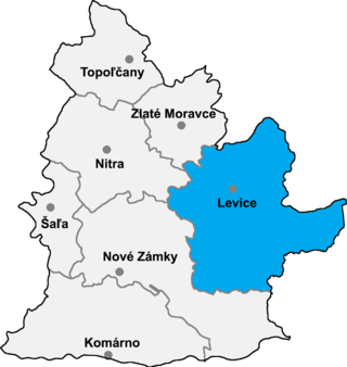
Farná is a village and municipality in the Levice District in the Nitra Region of Slovakia.

East Anstey is a village and civil parish in the North Devon district of Devon, England. The parish is located in an area which has been designated as an area of 'Great Landscape Value'. The village falls within the South Molton Deanery for ecclesiastical purposes. The village has a Grade II listed church, the Church of St Michael, which has a 15th-century tower and south porch but which was largely rebuilt in 1871.

Chocholná-Velčice is a village and municipality in Trenčín District in the Trenčín Region of north-western Slovakia.
The Esk'etemc First Nation, also known as the Alkali Lake Indian Band, is a First Nations government of the Secwepemc (Shuswap) people, located at Alkali Lake in the Cariboo region of the Central Interior of the Canadian province of British Columbia. It was created when the government of the then-Colony of British Columbia established an Indian reserve system in the 1860s. It is one of three Secwepemc bands that is not a member of either the Shuswap Nation Tribal Council or the Northern Shuswap Tribal Council.

Somerset Village is a small, unincorporated village in the northwest area of Bermuda, located in Sandys Parish. It lies in the northern half of Somerset Island.
O'Regan's is a village located north of Port aux Basques. It had a population of 110 by 1956.
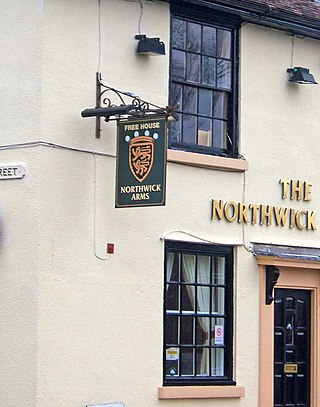
Northwick is a district of Worcester, England, located in the north of the city on the left (east) bank of the River Severn.
Lusuku is a town in the Lomami province of the Democratic Republic of the Congo.
Old Harbour is a town in southern Jamaica.

Ostrozub is a mountain in southern Serbia, near the town of Crna Trava. It forms a continuous range with Čemernik mountain. Its highest peak Ostrozupska čuka has an elevation of 1,546 meters above sea level.
Tagrin Point is the proposed location of a deep water port to replace the older and shallower port of Port Pepel in Sierra Leone. It would be connected to existing and new iron ore mined by an upgraded railway line converted to standard gauge.
Montpelier is a village located in Saint James Parish, Jamaica, approximately 15 minutes away from the parish's capital Montego Bay.
18°14′00″N77°52′00″W / 18.23333°N 77.86667°W
| | This Jamaican location article is a stub. You can help Wikipedia by expanding it. |