The Cache River National Wildlife Refuge is a 68,993 acre (223 km2) (2014) wildlife refuge in the state of Arkansas managed by the United States Fish and Wildlife Service (FWS). The refuge is one of the Ramsar wetlands of international importance under the Ramsar Convention signed in 1971. It is one of the most important wintering area for ducks and the largest remaining tract of contiguous bottomland hardwood forest on the North American continent. In 2005, a possible sighting of the ivory-billed woodpecker, thought to be extinct, brought attention to the refuge.
National Wildlife RefugeSystem (NWRS) is a system of protected areas of the United States managed by the United States Fish and Wildlife Service (FWS), an agency within the Department of the Interior. The National Wildlife Refuge System is the system of public lands and waters set aside to conserve America's fish, wildlife, and plants. Since President Theodore Roosevelt designated Florida's Pelican Island National Wildlife Refuge as the first wildlife refuge in 1903, the system has grown to over 568 national wildlife refuges and 38 wetland management districts encompassing about 856,000,000 acres (3,464,109 km2).

The Deep Fork National Wildlife Refuge (DFNWR) is part of the United States system of National Wildlife Refuges, and is a critical resource for wildfowl that migrate along the Central Flyway in Spring and Fall. It is located in Eastern Oklahoma, near the city of Okmulgee. The preserve runs along both banks of the Deep Fork River for about 20 miles (32 km). According to TravelOK, DFNWR receives about 45,000 visitors every year.

Missisquoi National Wildlife Refuge is a National Wildlife Refuge located in the eastern shore of Lake Champlain in the U.S. state of Vermont. The refuge is in Franklin County in the northwest corner of the state near the International Boundary with Canada. It is the only National Wildlife Refuge located entirely in Vermont, and is administered by the United States Fish and Wildlife Service.

The Edwin B. Forsythe National Wildlife Refuge is a U.S. National Wildlife Refuge located in southern and south-central New Jersey, along the Atlantic coast, north of Atlantic City, in Atlantic and Ocean counties. The refuge was created in 1984 out of two existing refuge parcels created to protect tidal wetland and shallow bay habitat for migratory water birds. The Barnegat Division is located in Ocean County on the inland side of Barnegat Bay. The Brigantine Division is located approximately 10 miles (16 km) north of Atlantic City along the south bank of the mouth of the Mullica River. The two divisions are separated by approximately 20 miles (32 km). The refuge is located along most active flight paths of the Atlantic Flyway, making it an important link in the network of national wildlife refuges administered nationwide by the U.S. Fish and Wildlife Service. Forsythe Refuge is a part of the Hudson River/New York Bight Ecosystem and The New Jersey Coastal Heritage Trail Route. The refuge is named for Edwin B. Forsythe, conservationist Congressman from New Jersey. The refuge was named as a Ramsar Site of international importance in 1986.
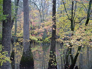
The Cache River is a 92-mile-long (148 km) waterway in southernmost Illinois, in a region sometimes called Little Egypt. The basin spans 737 square miles (1,910 km2) and six counties: Alexander, Johnson, Massac, Pope, Pulaski, and Union. Located at the convergence of four major physiographic regions, the river is part of the largest complex of wetlands in Illinois. The Cache River Wetlands is America's northernmost cypress/tupelo swamp and harbors 91 percent of the state's high quality swamp and wetland communities. It provides habitat for more than 100 threatened and endangered species in Illinois. In 1996, the Cache was designated a Wetland of International Importance by the Ramsar Convention.

The Okefenokee National Wildlife Refuge is a 402,000‑acre (1,627 km2) National Wildlife Refuge located in Charlton, Ware, and Clinch Counties of Georgia, and Baker County in Florida, United States. The refuge is administered from offices in Folkston, Georgia. The refuge was established in 1937 to protect a majority of the 438,000 acre (1,772 km2) Okefenokee Swamp. Though often translated as "land of trembling earth", the name "Okefenokee" is likely derived from Hitchiti oki fanôːki "bubbling water".

William L. Finley National Wildlife Refuge is a natural area in the Willamette Valley in Oregon, United States. It was created to provide wintering habitat for dusky Canada geese. Unlike other Canada geese, dusky Canada geese have limited summer and winter ranges. They nest on Alaska's Copper River Delta and winter almost exclusively in the Willamette Valley. Habitat loss, predation, and hunting have caused a decrease in population.

The Mingo National Wildlife Refuge is a 21,676-acre (87.7-km2) National Wildlife Refuge located in northwestern Stoddard and southeastern Wayne counties in Missouri. Its southwesternmost portion lies on the shores of Lake Wappapello. Named after the Mingo tribe, it was established to preserve bottomland hardwoods and provide waterfowl and other migratory birds in the Mississippi Flyway with nesting, feeding, brooding, and resting habitat.

Baskett Slough National Wildlife Refuge is in northwestern Oregon, 10 miles (16 km) west of Salem in Polk County. The Refuge consists of 1,173 acres (4.75 km2) of cropland, which provide forage for wintering geese, 300 acres (1.2 km2) of forests, 550 acres (2.2 km2) of grasslands, and 500 acres (2.0 km2) of shallow water seasonal wetlands and 35 acres (0.14 km2) of permanent open water. In 1965, Baskett Slough National Wildlife Refuge was created to help ensure some of the original habitat remained for species preservation. The refuge is managed by the U.S. Fish and Wildlife Service, an agency of the U.S. Department of the Interior.

The Tualatin River National Wildlife Refuge is a 1,856 acres (751 ha) wetlands and lowlands sanctuary in the northwestern part of the U.S. state of Oregon. Established in 1992 and opened to the public in 2006, it is managed by the United States Fish and Wildlife Service. Located in southeastern Washington County, 15 miles (24 km) southwest of Portland, the refuge is bordered by Sherwood, Tualatin and Tigard. A newer area, extending into northern Yamhill County, is located further west near the city of Gaston surrounding the former Wapato Lake.

Waccamaw National Wildlife Refuge, established in 1997, is a recent addition to the United States National Wildlife Refuge system. It is located in parts of northeastern Georgetown County, South Carolina, southern Horry, and southeastern Marion counties, and contains lands adjacent to the Pee Dee River, the Little Pee Dee River, and the Waccamaw River near their confluence. Currently the size of the refuge is 22,931 acres (92.80 km2) but plans call for the total refuge to be over 50,000 acres (200 km2).

Sherburne National Wildlife Refuge is a National Wildlife Refuge of the United States in Sherburne County, Minnesota. The 30,700-acre (124 km2) refuge protects mixed habitat types including oak savanna, Big Woods, and wetlands. The St. Francis River flows through the eastern side of the park. Over 230 species of birds, 58 species of mammals, and 25 species of reptiles and amphibians have been recorded in the refuge.

The Rachel Carson National Wildlife Refuge is a 9,125-acre (37 km2) National Wildlife Refuge made up of several parcels of land along 50 miles (80 km) of Maine's southern coast. Created in 1966, it is named for environmentalist and author Rachel Carson, whose book Silent Spring raised public awareness of the effects of DDT on migratory songbirds, and of other environmental issues.
D'Arbonne National Wildlife Refuge is a National Wildlife Refuge of the United States located north of West Monroe, Louisiana. It is in Ouachita and Union Parishes on either side of Bayou D'Arbonne near its confluence with the Ouachita River. It lies on the western edge of the Mississippi River alluvial valley. It was established in 1975 to protect bottomland hardwoods and provide wintering habitat for migratory waterfowl. D'Arbonne is one of four refuges managed in the North Louisiana Refuges Complex.
Lake Ophelia National Wildlife Refuge was established in 1988 to protect the Mississippi/Red River floodplain ecosystem. The refuge is located in Avoyelles Parish, Louisiana, east central Louisiana. The refuge is named for its most prominent water body, the 350-acre (1.4 km2) Lake Ophelia that was at one time a channel of the nearby Red River of the South.
The San Luis National Wildlife Refuge Complex is located in the northern San Joaquin Valley, within Merced County and Stanislaus County of California. The complex, with four federal National Wildlife Refuges, is managed by the U.S Fish & Wildlife Service.

Located in Coos County, New Hampshire and Oxford County, Maine, Umbagog National Wildlife Refuge is a northern treasure in the National Wildlife Refuge System. The diversity of exceptional habitats provides excellent breeding and foraging areas for migratory birds, endangered species, resident wildlife, and rare plants. The refuge protects over 25,650 acres (103.8 km2) of wetland and forested upland habitat along Umbagog Lake. About 70% of its area is in New Hampshire and 30% in Maine.

The Summer Lake Wildlife Area is a 29.6-square-mile (77 km2) wildlife refuge located on the northwestern edge of the Great Basin drainage in south-central Oregon. It is administered by the Oregon Department of Fish and Wildlife. The refuge is an important stop for waterfowl traveling along the Pacific Flyway during their spring and fall migrations. The Summer Lake Wildlife Area also provides habitat for shorebirds and other bird species as well as wide variety of mammals and several fish species. The Ana River supplies the water for the refuge wetlands.

