District of Arfon

Last updated

Arfon
Borough
Arfon au pays de Galles (1974-1996).svg
History
  Created1 April 1974
  Abolished31 March 1996
  Succeeded by Gwynedd
   HQ Bangor
Arfon logo.png
Contained within
  County Council Gwynedd

The Borough of Arfon was local government district with borough status from 1974 to 1996, being one of five districts in the county of Gwynedd, north-west Wales.

Contents

Etymology

Arfon means 'opposite Anglesey' (Ar + Fôn which is the soft mutation of Môn, the Welsh name for Anglesey). The name is ancient and has been used to designate the area since early medieval times. In the Middle Ages Cantref Arfon was an administrative territorial entity of the Kingdom of Gwynedd. Arfon survived as a geocultural name (Welsh : bro) over the centuries and remains in use today. It is also sometimes found as a personal name (e.g. Arfon Griffiths).

History

The borough was created on 1 April 1974, under the Local Government Act 1972. It covered the whole area of four former districts and most of a fifth from the administrative county of Caernarfonshire, which were all abolished at the same time: [1]

The new borough was named Arfon. [2]

Under the Local Government (Wales) Act 1994, the previous two tier system of counties and districts was replaced with new principal areas (each designated either a "county" or a "county borough"), whose councils perform the functions previously divided between the county and district councils. The Arfon area merged with Dwyfor and Meirionnydd to become a county which the government initially called "Caernarfonshire and Merionethshire". [3] During the transition to the new system, the shadow authority requested a change of name from "Caernarfonshire and Meirionethshire" to "Gwynedd". The government confirmed the change with effect from 2 April 1996, one day after the new council came into being. [4]

Political control

The first election to the council was held in 1973, initially operating as a shadow authority alongside the outgoing authorities until it came into its powers on 1 April 1974. The council consisted of 40 district councillors elected from 33 electoral wards. From 1987 this reduced to 39 councillors and 31 wards. [5] Political control of the council from 1974 until its abolition in 1996 was as follows: [6]

Party in controlYears
Independent 1974–1979
No overall control 1979–1996

Premises

Town Hall, Bangor (with Bangor University on the hill behind it), c. 2003 Town Hall (1).jpg
Town Hall, Bangor (with Bangor University on the hill behind it), c.2003

Arfon Borough Council was based at the Town Hall, Ffordd Gwynedd, Bangor. This was the former Bishop's Palace of the Bishop of Bangor, dating back to around 1500. The building ceased to be used as the bishop's residence in 1900, and was bought by the former Bangor City Council in 1903, who converted it to become their headquarters. [7] The building was renamed "Town Hall" (despite Bangor being a city) in 1908. [8] After Arfon Borough Council's abolition in 1996 the Town Hall was used as an area office of Gwynedd Council before being converted to become the Storiel museum and art gallery, which opened in 2016. [9]

Related Research Articles

<span class="mw-page-title-main">Caernarfon</span> Town in Gwynedd, Wales

Caernarfon is a royal town, community and port in Gwynedd, Wales. It has a population of 9,852. It lies along the A487 road, on the eastern shore of the Menai Strait, opposite the island of Anglesey. The city of Bangor is 8.6 miles (13.8 km) to the north-east, while Snowdonia (Eryri) fringes Caernarfon to the east and south-east.

<span class="mw-page-title-main">Gwynedd</span> County and preserved county in Wales

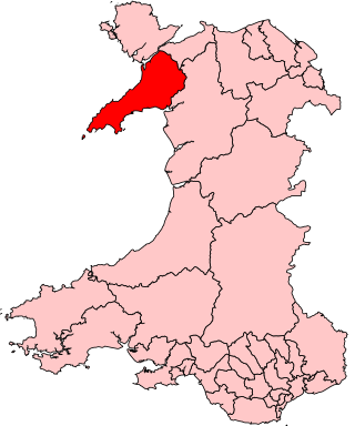
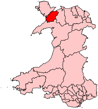
Gwynedd is a county in the north-west of Wales. It borders Anglesey across the Menai Strait to the north, Conwy, Denbighshire, and Powys to the east, Ceredigion over the Dyfi estuary to the south, and the Irish Sea to the west. The city of Bangor is the largest settlement, and the administrative centre is Caernarfon. The preserved county of Gwynedd, which is used for ceremonial purposes, includes the Isle of Anglesey.

<span class="mw-page-title-main">Caernarfonshire</span> Historic county of Wales

Until 1974, Caernarfonshire, sometimes spelled Caernarvonshire or Carnarvonshire, was an administrative county in the north-west of Wales, later classed as one of the thirteen historic counties of Wales.

<span class="mw-page-title-main">Meirionnydd</span> Region of Wales

Meirionnydd is a coastal and mountainous region of Wales. It has been a kingdom, a cantref, a district and, as Merionethshire, a county. It is currently an committee area within the county Gwynedd.

<span class="mw-page-title-main">Bangor, Gwynedd</span> City and community in Wales

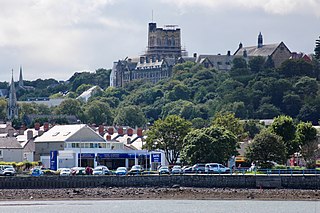
Bangor is a cathedral city and community in Gwynedd, North Wales. It is the oldest city in Wales. Historically part of Caernarfonshire, it had a population of 15,100 at the 2021 census. Landmarks include Bangor Cathedral, Bangor University and Garth Pier. The Britannia and Menai Suspension bridges connect the city to the Isle of Anglesey.

<span class="mw-page-title-main">Pwllheli</span> Town in north-west Wales

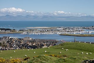
Pwllheli is a market town and community on the Llŷn Peninsula, north-west Wales. It lies in the traditional county of Caernarfonshire but is currently administered as part of the unitary authority of Gwynedd. It had a population of 4,076 in 2011, the population declining slightly to 3,947 in 2021. of whom a large proportion, 81%, were Welsh speaking. Pwllheli is the place where Plaid Cymru was founded. It is the birthplace of the Welsh poet Sir Albert Evans-Jones.

<span class="mw-page-title-main">North Wales</span> Geographic region in Wales

North Wales is a region of Wales, encompassing its northernmost areas. It borders mid Wales to the south, England to the east, and the Irish Sea to the north and west. The area is highly mountainous and rural, with Snowdonia National Park and the Clwydian Range and Dee Valley, known for its mountains, waterfalls and trails, wholly within the region. Its population is concentrated in the north-east and northern coastal areas, with significant Welsh-speaking populations in its western and rural areas. North Wales is imprecisely defined, lacking any exact definition or administrative structure. It is commonly defined administratively as its six most northern principal areas, but other definitions exist, with Montgomeryshire historically considered to be part of the region.

<span class="mw-page-title-main">District of Aberconwy</span> Former district of Gwynedd, Wales

The Borough of Aberconwy was a local government district with borough status from 1974 to 1996, being one of five districts in the county of Gwynedd, north-west Wales.

<span class="mw-page-title-main">Dwyfor</span> Former district of Gwynedd, Wales

Dwyfor was one of the five local government districts of Gwynedd, Wales from 1974 to 1996, covering the Llŷn peninsula. Its council was based in Pwllheli.

<span class="mw-page-title-main">Caernarfon (UK Parliament constituency)</span> Parliamentary constituency in the United Kingdom, 1801–2010

Caernarfon was a parliamentary constituency centred on the town of Caernarfon in Wales. It elected one Member of Parliament (MP) by the first past the post system.

<span class="mw-page-title-main">Local Government (Wales) Act 1994</span> United Kingdom legislation

The Local Government (Wales) Act 1994 is an Act of the Parliament of the United Kingdom which amended the Local Government Act 1972 to create the current local government structure in Wales of 22 unitary authority areas, referred to as principal areas in the Act, and abolished the previous two-tier structure of counties and districts. It came into effect on 1 April 1996.

<span class="mw-page-title-main">Arfon (UK Parliament constituency)</span> Parliamentary constituency in the UK

Arfon is a constituency in Wales represented in the House of Commons of the UK Parliament at Westminster. Although it is relatively large by geographical area, the constituency is a predominantly urban rather than rural seat, with the majority of the population living in the two towns of Bethesda and Caernarfon, as well as in the city of Bangor, on which the constituency is based. "Arfon" is a historical name for the area, meaning "facing Anglesey"; it is also the name of the former district council. This seat was created by the Welsh Boundary Commission in time for the 2010 general election; it replaced the old seat of Caernarfon. Bangor was in the old seat of Conwy. The same boundaries were used for the Arfon Welsh Assembly constituency in the 2007 Welsh Assembly election.

<span class="mw-page-title-main">Isle of Anglesey County Council</span> Local government authority in north-west Wales

The Isle of Anglesey County Council is the local authority for the Isle of Anglesey, a principal area with county status in Wales. Since 2022 the council has 35 councillors who represent 11 multi-member electoral wards.

<span class="mw-page-title-main">Gwynedd Council</span> Local government authority in north-west Wales

Gwynedd Council, which calls itself by its Welsh name Cyngor Gwynedd, is the governing body for the county of Gwynedd, one of the principal areas of Wales. The council administrates internally using the Welsh language.

Ogwen was a rural district in the administrative county of Caernarfonshire in Wales from 1894 to 1974.

<span class="mw-page-title-main">Arfon (cantref)</span> Welsh medieval cantref

Arfon was a mediaeval Welsh cantref in north-west Wales. It was the core of the kingdom of Gwynedd. Later it was included in the new county of Caernarfonshire, together with Llŷn and Arllechwedd under the terms of the Statute of Rhuddlan in 1284. The island of Anglesey faced it across the Menai Strait; to the east was the cantref of Arllechwedd, to the south the cantref of Eifionydd, and to the west was the cantref of Llŷn.

<span class="mw-page-title-main">Bangor City Council</span> Community council for Bangor in Gwynedd, Wales

Bangor City Council or officially the City of Bangor Council is an elected community council serving Bangor in Gwynedd, Wales.

Menai is the name of an electoral ward in the town of Caernarfon, Gwynedd, Wales. As the name suggests, it borders the Menai Strait. The ward elects councillors to the town council and Gwynedd Council.

<span class="mw-page-title-main">Bangor Town Hall</span> Municipal Building in Bangor, Wales

Bangor Town Hall, formerly The Bishop's Palace, is a municipal building on Ffordd Deiniol, in Bangor, Gwynedd, Wales. The structure, which is now used as a museum, is a Grade II listed building.

References

  1. "Local Government Act 1972", legislation.gov.uk , The National Archives, 1972 c. 70, retrieved 5 November 2022
  2. "The Districts in Wales (Names) Order 1973", legislation.gov.uk , The National Archives, SI 1973/34, retrieved 30 October 2022
  3. "Local Government (Wales) Act 1994", legislation.gov.uk , The National Archives, 1994 c. 19, retrieved 8 November 2022
  4. "Hansard: Written Answers". UK Parliament. 2 April 1996. Retrieved 3 October 2022.
  5. "Arfon Welsh District Council Election Results 1973–1991" (PDF). The Elections Centre (Plymouth University). Retrieved 24 April 2019.
  6. "Compositions calculator". The Elections Centre. Retrieved 18 November 2022.
  7. "Bishop's Palace; Town Hall; Neuadd y Dref". Coflein. Royal Commission on the Ancient and Historical Monuments of Wales. Retrieved 18 November 2022.
  8. "Bangor Town Hall". Carnarvon and Denbigh Herald. Caernarfon. 10 January 1908. p. 6. Retrieved 18 November 2022.
  9. Williams, Mike (23 February 2016). "Bangor's new Storiel centre saw 5,000 visitors before it even officially opened". North Wales Chronicle. Retrieved 18 November 2022.

53°05′N4°00′W / 53.083°N 4.000°W / 53.083; -4.000