 |
|---|
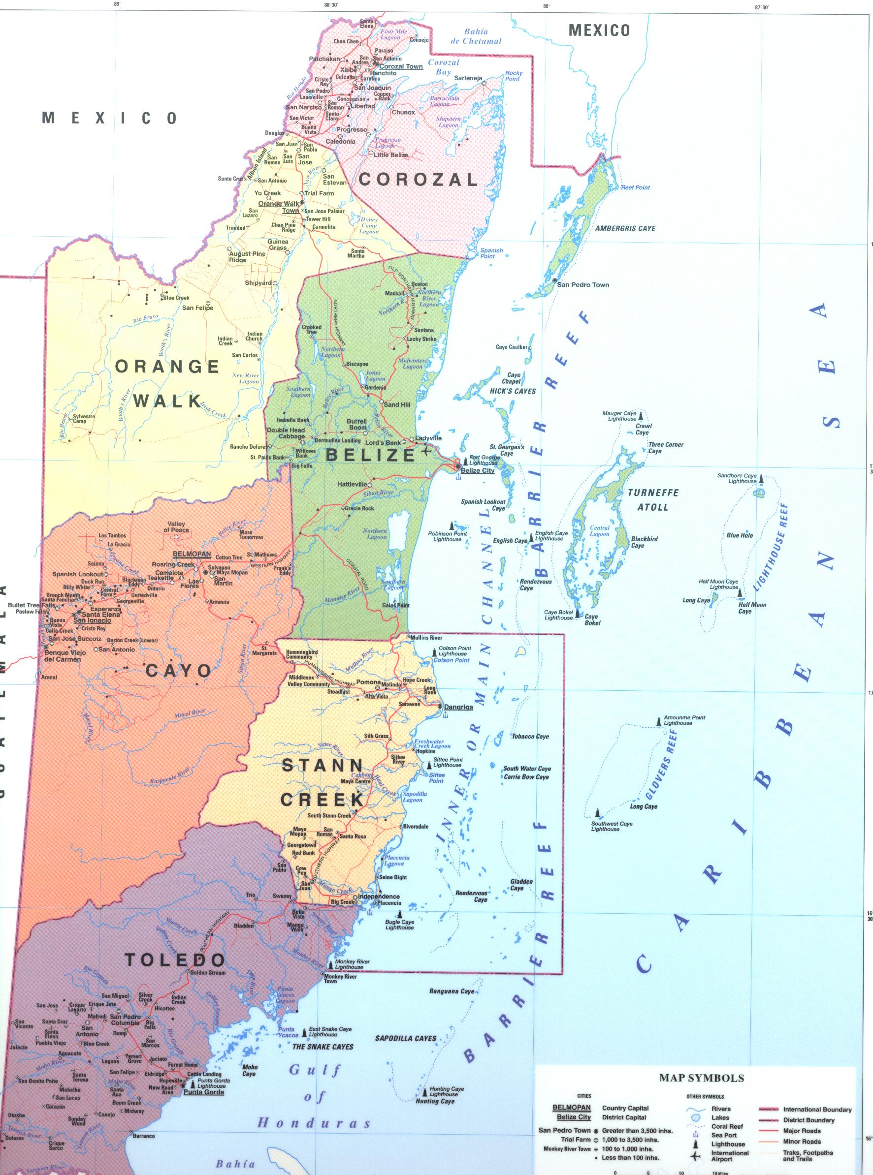
Belize is divided into six districts, those six are, from top to bottom, called Corozal, Orange Walk, Belize (District) Cayo, Stann Creek, and Toledo.
| |
|---|
Belize is divided into six districts, those six are, from top to bottom, called Corozal, Orange Walk, Belize (District) Cayo, Stann Creek, and Toledo.

| District | Capital | Area [1] | Population (2019) [2] | Population (2010) [1] | Change | Population density (2019) |
|---|---|---|---|---|---|---|
| Belize | Belize City | 4,310 km2 (1,663 sq mi) | 124,096 | 95,292 | +30.2% | 28.8/km2 (74.6/sq mi) |
| Cayo | San Ignacio | 5,200 km2 (2,006 sq mi) | 99,118 | 75,046 | +32.1% | 19.1/km2 (49.4/sq mi) |
| Corozal | Corozal Town | 1,860 km2 (718 sq mi) | 49,446 | 41,061 | +20.4% | 26.6/km2 (68.9/sq mi) |
| Orange Walk | Orange Walk Town | 4,600 km2 (1,790 sq mi) | 52,550 | 45,946 | +14.4% | 11.3/km2 (29.4/sq mi) |
| Stann Creek | Dangriga | 2,550 km2 (986 sq mi) | 44,720 | 34,324 | +30.3% | 17.5/km2 (45.4/sq mi) |
| Toledo | Punta Gorda | 4,410 km2 (1,704 sq mi) | 38,557 | 30,785 | +25.2% | 8.7/km2 (22.6/sq mi) |

Belize is a country on the north-eastern coast of Central America. It is bordered by Mexico to the north, the Caribbean Sea to the east, and Guatemala to the west and south. It also shares a water boundary with Honduras to the southeast. It has an area of 22,970 square kilometres (8,867 sq mi) and a population of 441,471 (2022). Its mainland is about 290 km (180 mi) long and 110 km (68 mi) wide. It is the least populated and least densely populated country in Central America. Its population growth rate of 1.87% per year is the second-highest in the region and one of the highest in the Western Hemisphere. Its capital is Belmopan, and its largest city is the namesake city of Belize City. Belize is often thought of as a Caribbean country in Central America because it has a history similar to that of English-speaking Caribbean nations. Belize's institutions and official language reflect its history as a British colony.
Stone County is located in the Ozark Mountains in the U.S. state of Arkansas. The county is named for rugged, rocky area terrain of the Ozarks. Created as Arkansas's 74th county on April 21, 1873, Stone County has two incorporated cities: Mountain View, the county seat and most populous city, and Fifty-Six. The county is also the site of numerous unincorporated communities and ghost towns.

Dangriga, formerly known as Stann Creek Town, is a town in southern Belize, located on the Caribbean coast at the mouth of the North Stann Creek River. It is the capital of Belize's Stann Creek District. Dangriga is served by the Dangriga Airport. Commonly known as the "culture capital of Belize" due to its influence on punta music and other forms of Garifuna culture, Dangriga is the largest settlement in southern Belize.

Punta Gorda, known locally as P.G., is the capital and largest town of Toledo District in southern Belize. Punta Gorda is the southernmost sizable town in the nation, with a population of about 5,000 people. Although the town bears a Spanish name, its inhabitants are mostly Kriol/English-speaking, and are primarily of Garifuna, East Indian, Kriol, and Maya descent.

Corozal Town is a town in Belize, capital of Corozal District. Corozal Town is located about 84 miles north of Belize City, and 9 miles from the border with Mexico. The population of Corozal Town, according to the main results of the 2010 census, is 9,871.

Orange Walk Town is the fourth largest town in Belize, with a population of about 13,400. It is the capital of the Orange Walk District. Orange Walk Town is located on the left bank of the New River, 53 miles (85 km) north of Belize City and 30 miles (48 km) south of Corozal Town. Despite the English name of the city, its residents are primarily Spanish-speaking mestizos. The city is in a very low-lying area of Belize, though the police station sits atop a buried Mayan pyramid at 49 m (161 ft) tall.

Benque Viejo del Carmen ("Benque") is the westernmost town in Belize, 130 km (81 mi) by road west and south of Belize City, at the Guatemalan border. San Ignacio lies 13 km to the east and Melchor de Mencos just across the border. The Mopan River runs along the town's north and west edges.

Stann Creek District is a district in the south east region of Belize. According to the 2010 census, the district had a population of 32,166 people. Its capital is the town of Dangriga, formerly known as "Stann Creek Town." Stann comes from "stanns," or safe havens used by colonialists coming from the "old world" to the "new world."

Toledo District is the southernmost and least populated district in Belize. Punta Gorda is the District capital. According to the Human Development Index (HDI), it is the second most developed region in the country. The district has a diverse topography which features rainforests, extensive cave networks, coastal lowland plains, and offshore cays. Toledo is home to a wide range of cultures such as Mopan, Kekchi Maya, Creole, Garifuna, East Indians, Mennonites, Mestizos, and descendants of US Confederate settlers.
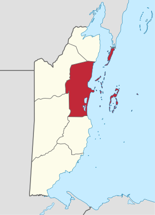
Belize District is a district of the nation of Belize. Its capital is Belize City.

Orange Walk District is a district in the northwest of the nation of Belize, with its district capital in Orange Walk Town.
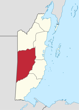
Cayo District is a district located in the west part of Belize. It is the most extensive, second-most populous and third-most densely populated of the six districts of Belize. The district's capital is the town of San Ignacio.
San Ignacio and Santa Elena are towns in western Belize. San Ignacio serves as the cultural-economic hub of Cayo District. It got its start from mahogany and chicle production during British colonisation. Over time it attracted people from the surrounding areas, which led to the diverse population of the town today. San Ignacio is the largest settlement in Cayo District and the second largest in the country, after Belize City.

According to the 2010 census, the major languages spoken in Belize include English, Spanish and Kriol, all three spoken by more than 40% of the population. Mayan languages are also spoken in certain areas, as well as German.

Hinduism is a minority faith in Belize. According to 2010 census, 0.2% of Belize population is Hindu.
Christianity is the dominant religion in Belize. The single largest denomination is the Roman Catholic Church with about 40.1% of the population, a reduction from 49.6% of the population in 2000, 57.7% in 1991 and 61.9% in 1980, although absolute numbers have still risen. Other major groups include Pentecostal with 8.4% of the population up from 7.4% in 2000 and 6.3% in 1991, Seventh-day Adventists with 5.4% of the population up from 5.2% in 2000 and 4.1% in 1991. The following of the Anglican Church has been steadily declining, with only 4.7% of the population in 2010 compared to 6.95% in 1991. About 12,000 Mennonites live mostly in the rural districts of Cayo and Orange Walk. People who declared they belong to no religion make up 15.5% of the population in 2010, more than double their 2000 census numbers. 11.2% adhere to other religions which include the Maya religion, Afro-American religions, Mormons, Hindus, Buddhists, Muslims, Baháʼís, Rastafarians and others.

Belize's 6 districts are politically divided into 31 constituencies. Each constituency sends one representative to Belize's House of Representatives for 5-year terms. This election is known as the General Election. Each person votes for the candidate they would want to represent their constituency in Central Government.
His Majesty's Government in Belize, also referred to as the Belizean Government is the democratic administrative authority of Belize, a constitutional monarchy under a parliamentary democracy. It was formed in 1981 after gaining sovereignty from the United Kingdom. The constitution is the supreme law of Belize.

Bullet Tree Falls is a village located along the Mopan River in Cayo District, Belize. It lies approximately five kilometers northwest of San Ignacio. According to the 2010 census, Bullet Tree Falls has a population of 2,124 people in 426 households. The population consists mainly of Spanish-speaking mestizos, along with a smaller number of Yucatec Maya and Creoles.
