
Gem County is a county in the U.S. state of Idaho. As of the 2010 census, the population was 16,719. The county seat and largest city is Emmett.
Derby Dam is a diversion dam built from 1903 to 1905 on the Truckee River, located about 20 miles (32 km) east of Reno in Storey and Washoe counties in Nevada, United States. It diverts water into the Truckee Canal that would otherwise enter Pyramid Lake. The canal feeds Lake Lahontan reservoir in the Carson River watershed, where it is used for irrigation.

The Boise River is a 102-mile-long (164 km) tributary of the Snake River in the Northwestern United States. It drains a rugged portion of the Sawtooth Range in southwestern Idaho northeast of Boise, as well as part of the western Snake River Plain. The watershed encompasses approximately 4,100 square miles (11,000 km2) of highly diverse habitats, including alpine canyons, forest, rangeland, agricultural lands, and urban areas.

The American Falls Dam is a concrete gravity-type dam located near the town of American Falls, Idaho, on river mile 714.7 of the Snake River. The dam and reservoir are a part of the Minidoka Project on the Snake River Plain and are used primarily for flood control, irrigation, and recreation. When the original dam was built by the Bureau of Reclamation, the residents of American Falls were forced to relocate three-quarters of their town to make room for the reservoir. A second dam was completed in 1978 and the original structure was demolished. Although the dam itself is located in Power County, its reservoir also stretches northeastward into both Bingham County and Bannock County.
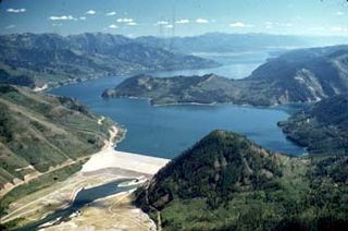
Palisades Dam is an earth-fill dam in the western United States, on the upper Snake River in eastern Idaho. Located in Bonneville County near the Wyoming border, the dam was completed 65 years ago in 1957.

This is a directory of properties and districts included among the National Register of Historic Places listings in Idaho. There are approximately 1,000 sites in Idaho listed on the National Register. Each of the state's 44 counties has at least one listing on the National Register.
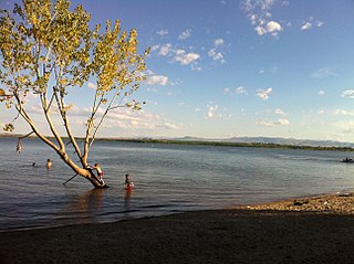
The Deer Flat National Wildlife Refuge is an important breeding area for mammals, birds, and other animals. The National Wildlife Refuge is located on land surrounding Lake Lowell, just outside Nampa, Idaho. It serves as a resting and wintering area for birds, including mallards and Canada geese, along the Pacific Flyway and was named a "Globally Important Bird Area" by the American Bird Conservancy.

Jackson Lake Dam is a concrete and earth-fill dam in the western United States, at the outlet of Jackson Lake in northwestern Wyoming. The lake and dam are situated within Grand Teton National Park in Teton County. The Snake River emerges from the dam and flows about eight hundred miles (1,300 km) through Wyoming, Idaho, Oregon, and Washington to its mouth on the Columbia River in eastern Washington.
Owyhee Dam is a concrete arch-gravity dam on the Owyhee River in Eastern Oregon near Adrian, Oregon, United States. Completed in 1932 during the Great Depression, the dam generates electricity and provides irrigation water for several irrigation districts in Oregon and neighboring Idaho. At the time of completion, it was the tallest dam of its type in the world. The dam is part of the Owyhee Dam Historic District, which is listed on the National Register of Historic Places.

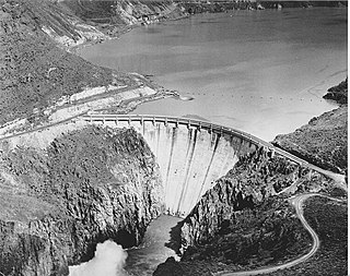
Arrowrock Dam is a concrete arch dam in the western United States, on the Boise River in southwestern Idaho, east of Boise. Opened 107 years ago in 1915, it is located on the border of Boise and Elmore counties, upstream of the Lucky Peak Dam and reservoir. The spillway elevation for Arrowrock is 3,219 feet (981 m) above sea level and its primary purpose is to provide irrigation water for agriculture.
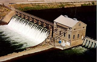
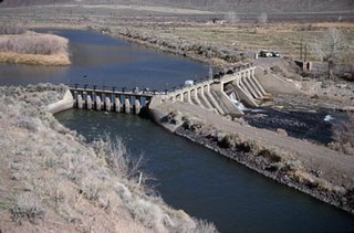
The Boise River Diversion Dam is a diversion dam in the western United States, on the Boise River in southwestern Idaho. Seven miles (11 km) southeast and upstream of Boise in Ada County, it was completed 113 years ago in 1909 and is operated by the U.S. Bureau of Reclamation.
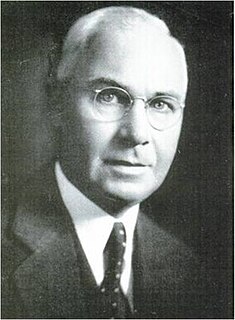
John Lucian Savage was an American civil engineer. Among the 60 major dams he supervised the designs for, he is best known for the Hoover Dam, Shasta Dam, Parker Dam and Grand Coulee Dam in the United States along with surveying for the future Three Gorges Dam in China. He was a member of the National Academy of Sciences and the recipient of numerous awards including the John Fritz Medal.

The Minidoka Project is a series of public works by the U.S. Bureau of Reclamation to control the flow of the Snake River in Wyoming and Idaho, supplying irrigation water to farmlands in Idaho. One of the oldest Bureau of Reclamation projects in the United States, the project involves a series of dams and canals intended to store, regulate and distribute the waters of the Snake, with electric power generation as a byproduct. The water irrigates more than a million acres (4,000 km²) of otherwise arid land, producing much of Idaho's potato crop. Other crops include alfalfa, fruit and sugar beets. The primary irrigation district lies between Ashton in eastern Idaho and Bliss in the southwestern corner of the state. Five main reservoirs collect water, distributing it through 1,600 miles (2,600 km) of canals and 4,000 miles (6,400 km) of lateral distribution ditches.

The Grand Valley Diversion Dam is a diversion dam in the De Beque Canyon of the Colorado River, about 15 miles (24 km) northeast of Grand Junction, Colorado in the United States. It is a 14-foot (4.3 m) high, 546-foot (166 m) long concrete roller dam with six gates, which were the first and largest of their kind to be installed in the United States.
Deer Flat Upper Embankment is a dam in the western United States in southwestern Idaho. Located in the Treasure Valley in Canyon County, it is directly southwest of Nampa.
The Percha Diversion Dam is a structure built in 1918 on the Rio Grande in New Mexico, United States. It diverts water from the Rio Grande into the Rincon Valley Main Canal, an irrigation canal.

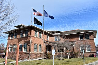
The Nampa and Meridian Irrigation District Office in Nampa, Idaho, is a 1-story brick and concrete building designed by Tourtellotte and Hummel and completed in 1919. The building features tall, narrow window fenestrations topped by large, vertical keystones with sidestones. Most of the windows have been replaced by a flat stucco surface painted brilliant white. The site was listed on the National Register of Historic Places in 1982.
The Reclamation Service Boise Project Office in Boise, Idaho, is a 2-story, L-shape Bungalow with entry at a porch on the inside corner. Finished in 1912, the building is constructed of brick with corbels separating basement, first, and second floors, and it includes segmented arch window openings. The low pitched roof includes four dormers.

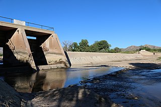
The New York Canal is an irrigation canal in the western United States, located in southwestern Idaho. Sourced from the Boise River, it originates at the Diversion Dam in Ada County and ends after 41 miles (66 km) at Lake Lowell in Canyon County.


