In the 2020 Census, the ten county area had a combined population of 845,395 people; 45.9% of the state's population.[3] Ada and Canyon are the two most populous counties in Idaho, and both have (respectively) experienced a 36.6% and 31.2% growth in population since 2010, making them among the fastest growing counties in terms of population in the state.[4]
Southwestern Idaho was originally inhabited by three main Native American tribes: the Shoshone-Bannock, the Nez Perce, and the Northern Paiute. These people were among the first inhabitants in Idaho, first living in the area as early as 12,000 years ago.[5] The Native Americans tribes were nomadic, adopting a hunter-gatherer lifestyle, and had an annual rendezvous in the Boise Valley, which also included catching salmon.[6]
Spanish explorers in the late 1500s explored parts of the American West, including southwestern Idaho, and introduced the Native Americans of the area to pigs, horses, domestic fowl, corn, tomatoes, and garlic. After the Lewis & Clark Expedition through Idaho, French-Canadian fur trappers further explored the area. Mountain men, including Spaniards and Mexicans, lived off the land in Southwestern Idaho, trading with the Native Americans in the area. However, it wasn't until further development in Oregon, the mass exodus of settlers to the West on the Oregon, Californian, and Mormon trails, the establishment of Fort Boise, and the Idaho Gold Rush in the 1850s and 60s that settling of Southwestern Idaho began to increase. In order to support mining towns, such as Idaho City, Booneville, Ruby City, and Silver City, numerous ranching and agriculture businesses were set up in the area.[7][8] One of the biggest ranching operations in 1869 was in Owyhee County, where an original 1,400 head of cattle was driven around the county, forging the area's cattle industry that persists today. At an unknown time, there were an estimated 100,000 head of cattle in the area of Owyhee.[8]
This piece of country is worth looking after. The lakes and streams abound with fish at this time of the year and the game is plentiful…. The Payette Lake, a beautiful sheet of water 12 miles long, in places is dotted with richly wooded inlets set like emerald gems on the bosom of the liquid mirror.
Meanwhile, communities in the forests and mountains of Southwestern Idaho began to grow. N. B. Willey, future governor of Idaho, wrote to the Warren Times, creating interest in the area around Payette Lake, the future site of McCall. In a few years, commercial fisheries would come to operation on Payette Lake, selling fresh, salted, and dried Chinook salmon and white fish to the areas in the Boise Valley. Overtime, infrastructure, including a hotel, the Meadow-to-Warren Trail (now Idaho State Highway 55), and a post office led to the southern shore of Payette Lake to become the center of mining, recreation, forestry, and agriculture for the McCall area. Over the next 20 years, expansion would continue with commercial camps, more hotels, private clubs, church camps, and scenic tours.[9]
During this time period, the Native American tribes that had inhabited Southwestern Idaho were forced onto reservations in the 1870s, with the Nez Perce War being a key conflict during this time period. By 1877, all tribes native to Southwestern Idaho were located on reservations.[10]
Rapid and exponential growth was relatively contained by the limits of agriculture and irrigation over the next half century, as Southwestern Idaho has an arid climate that makes long-term, practical farming difficult. Numerous small-scale, private companies aimed to establish irrigation in the lands outside of the easily watered lands near the Boise Valley, but were often disorganized, and had difficulty upscaling to larger areas. As such, the Casey Act, passed in 1894, allowed for the reclamation states with public lands to sell 160-acre plots of lands to farmers, which would then have irrigation districts approved by the state's office of reclamation engineering to bring irrigation to those pieces of acreage; a notable example is the Pioneer Irrigation District, established by 1900 near Caldwell and the surrounding areas (such as Notus and Middleton).
Cherry orchards, farm land, and irrigation located in Emmett, Idaho. This photo was taken in July 1941.
Idaho benefitted the most from the Casey Act, with around 60% of all land utilized by the Casey Act was located in Idaho, including Southwestern Idaho. In the early 1900s, reclamation projects, such as Arrowrock Dam, the New York Canal, the Cascade Dam, and the Anderson Ranch Dam all helped irrigate and make the area more sustainable and liveable. These projects, coupled alongside the underground pumping of water (started in 1950) continue to supply Southwestern Idaho with its necessary water supply.[11]
In recent history, three cities in Southwestern Idaho were among the fastest growing in the country: Meridian, Nampa, and Caldwell all experienced population growths greater than or equal to 5% from July 2020 to July 2021.[12] For context, Idaho is one of the fastest growing states in the United States; in 2022, census officials estimated that Idaho's population had grown by 1.8% from July 2021 to July 2022, making it the second-fastest growing state in the country.[13]
Today, Southwestern Idaho is Idaho's primary and most well-known metropolitan area, with numerous industries, with the largest (by average employees) being education and health services; trade, transportation, and utilities; professional and business services; leisure and hospitality; and construction.[14]
Boise is the capital and most populous city in the U.S. state of Idaho and is the county seat of Ada County. As of the 2020 census, there were 235,684 people residing in the city. On the Boise River in southwestern Idaho, it is 41 miles (66 km) east of the Oregon border and 110 miles (177 km) north of the Nevada border. The downtown area's elevation is 2,704 feet (824 m) above sea level.
Owyhee County is a county in the southwestern corner of the U.S. state of Idaho. As of the 2020 census, the population was 11,913. The county seat is Murphy, and its largest city is Homedale. In area it is the second-largest county in Idaho, behind Idaho County.
Canyon County is located in the U.S. state of Idaho. As of the 2020 Census, the population was 231,105, which by 2022 was estimated to have risen to 251,065. making it the second-most populous county in Idaho. The county seat is Caldwell, and its largest city is Nampa. Canyon County is part of the Boise metropolitan area.
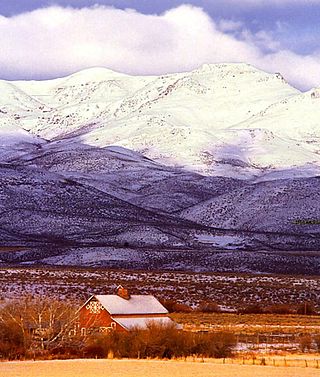
Boise County is a rural mountain county in the U.S. state of Idaho. As of the 2020 United States Census, the population was 7,610. The county seat is historic Idaho City, which is connected through a series of paved and unpaved roads to Lowman, Centerville, Placerville, Pioneerville, Star Ranch, Crouch, Garden Valley, and Horseshoe Bend.
Meridian is a city located in Ada County, Idaho, United States. The population was 117,635 at the 2020 census, making it the 2nd most populous city in the county and Idaho after Boise, the state capital. Meridian is considered the state's fastest-growing city and among the fastest-growing cities in the United States.
Nampa is the most populous city in Canyon County, Idaho, United States. The population was 100,200 at the 2020 census. It is Idaho's 3rd most populous city. Nampa is about 20 miles (32 km) west of Boise along Interstate 84, and 6 miles (9.7 km) west of Meridian. It is the second principal city of the Boise metropolitan area. The name "Nampa" may have come from a Shoshoni word meaning either 'moccasin' or 'footprint'. According to toponymist William O. Bright the name comes from the Shoshoni word /nampai/, meaning "foot".
The Boise–Nampa, Idaho Metropolitan Statistical Area (MSA) is an area that encompasses Ada, Boise, Canyon, Gem, and Owyhee counties in southwestern Idaho, anchored by the cities of Boise and Nampa. It is the main component of the wider Boise–Mountain Home–Ontario, ID–OR Combined Statistical Area, which adds Elmore and Payette counties in Idaho and Malheur County, Oregon. It is the state's largest officially designated metropolitan area and includes Idaho's three largest cities: Boise, Nampa, and Meridian. Nearly 40 percent of Idaho's total population lives in the area.
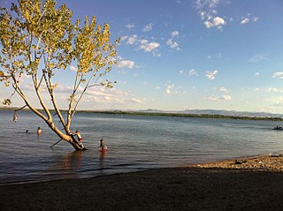
The Treasure Valley is a valley in the western United States, primarily in southwestern Idaho, where the Payette, Boise, Weiser, Malheur, Owyhee rivers drain into the Snake River. It includes all the lowland areas from Vale in rural eastern Oregon to Boise, and is the most populated area in Idaho.
The Payette River is an 82.7-mile-long (133.1 km) river in southwestern Idaho and is a major tributary of the Snake River.
The Boise Metropolitan Statistical Area is served by six major television stations, two daily newspapers, three major weekly newspapers and 19 major commercial radio stations.
The Deer Flat National Wildlife Refuge is an important breeding area for mammals, birds, and other animals. The National Wildlife Refuge is located on land surrounding Lake Lowell, just outside Nampa, Idaho. It serves as a resting and wintering area for birds, including mallards and Canada geese, along the Pacific Flyway and was named a "Globally Important Bird Area" by the American Bird Conservancy.
The Roman Catholic Diocese of Boise Regions are deaneries for geographic areas of the state of Idaho. The areas are further defined by parishes, stations, and chapels. The Diocese of Boise is a suffragan of the Roman Catholic Archdiocese of Portland.
Interstate 84 (I-84) in the U.S. state of Idaho is a major Interstate Highway that traverses the state from the Oregon state line in the northwest to Utah state line in the southeast. It primarily follows the Snake River across a plain that includes the cities of Boise, Mountain Home, and Twin Falls. The highway is one of the busiest in Idaho and is designated as the Vietnam Veterans Memorial Highway.
State Highway 55 (SH-55) is an Idaho highway from Marsing to New Meadows, connecting with US-95 at both ends.
Tourtellotte & Hummel was an American architectural firm from Boise, Idaho and Portland, Oregon.
Deer Flat Upper Embankment is a dam in the western United States in southwestern Idaho. Located in the Treasure Valley in Canyon County, it is directly southwest of Nampa.
Claytonia is an unincorporated community in Owyhee County in the southwestern part of the U.S. state of Idaho.
This page is based on this Wikipedia article Text is available under the CC BY-SA 4.0 license; additional terms may apply. Images, videos and audio are available under their respective licenses.