Payette County, Idaho

Last updated

Payette County
Payette City Hall-Courthouse 2 - Payette Idaho.jpg
Payette County, Idaho seal.png
Map of Idaho highlighting Payette County.svg
Location within the U.S. state of Idaho
Idaho in United States.svg
Idaho's location within the U.S.
Coordinates: 44°01′N116°46′W / 44.01°N 116.76°W / 44.01; -116.76
CountryFlag of the United States.svg United States
StateFlag of Idaho.svg  Idaho
FoundedFebruary 28, 1917
Named for Francois Payette
Seat Payette
Largest cityPayette
Area
  Total410 sq mi (1,100 km2)
  Land407 sq mi (1,050 km2)
  Water3.4 sq mi (9 km2)  0.65%
Population
 (2020)
  Total25,386
  Density62/sq mi (24/km2)
Time zone UTC−7 (Mountain)
  Summer (DST) UTC−6 (MDT)
Congressional district 1st
Website www.payettecounty.org

Payette County is a county located in Idaho in the United States of America. As of the 2020 census, the population was 25,386. [1] The county seat and largest city is Payette. [2]

Contents

Payette County is part of the Ontario micropolitan area.

History

The county was established in 1917, partitioned from Canyon County. It was named after the Payette River, which was named after French-Canadian François Payette. [3] Originally a fur trapper with the North West Company, Payette was the first white man in the area in 1818.

Payette County is one of the few counties in Idaho to be the home to the endangered Idaho ground squirrel.

Geography

According to the U.S. Census Bureau, the county has a total area of 410 square miles (1,100 km2), of which 407 square miles (1,050 km2) is land and 3.4 square miles (8.8 km2) (0.8%) is water. [4] It is the smallest county in Idaho by area.

Adjacent counties

National protected area

Rivers

Highways

Demographics

Historical population
CensusPop.Note
1920 7,021
1930 7,3184.2%
1940 9,51130.0%
1950 11,92125.3%
1960 12,3633.7%
1970 12,4010.3%
1980 15,72226.8%
1990 16,4344.5%
2000 20,57825.2%
2010 22,6239.9%
2020 25,38612.2%
2023 (est.)27,279 [5] 7.5%
U.S. Decennial Census [6]
1790–1960, [7] 1900–1990, [8]
1990–2000, [9] 2010, [10]

2000 census

As of the census [11] of 2000, there were 20,578 people, 7,371 households, and 5,572 families living in the county. The population density was 50 inhabitants per square mile (19/km2). There were 7,949 housing units at an average density of 20 per square mile (7.7/km2). The racial makeup of the county was 90.25% White, 0.87% Native American, 0.85% Asian, 0.10% Black or African American, 0.03% Pacific Islander, 5.57% from other races, and 2.33% from two or more races. 11.92% of the population were Hispanic or Latino of any race. 19.5% were of German, 13.5% English, 12.3% American and 8.3% Irish ancestry.

There were 7,371 households, out of which 37.70% had children under the age of 18 living with them, 62.00% were married couples living together, 9.30% had a female householder with no husband present, and 24.40% were non-families. 20.60% of all households were made up of individuals, and 9.50% had someone living alone who was 65 years of age or older. The average household size was 2.78 and the average family size was 3.21.

In the county, the population was spread out, with 30.60% under the age of 18, 7.90% from 18 to 24, 26.60% from 25 to 44, 21.70% from 45 to 64, and 13.20% who were 65 years of age or older. The median age was 34 years. For every 100 females, there were 98.30 males. For every 100 females age 18 and over, there were 94.80 males.

The median income for a household in the county was $33,046, and the median income for a family was $37,430. Males had a median income of $30,641 versus $21,421 for females. The per capita income for the county was $14,924. About 9.70% of families and 13.20% of the population were below the poverty line, including 16.70% of those under age 18 and 12.20% of those age 65 or over.

2010 census

As of the 2010 United States Census, there were 22,623 people, 8,262 households, and 6,017 families living in the county. [12] The population density was 55.6 inhabitants per square mile (21.5/km2). There were 8,945 housing units at an average density of 22.0 per square mile (8.5/km2). [13] The racial makeup of the county was 88.6% white, 1.1% American Indian, 0.8% Asian, 0.2% black or African American, 0.1% Pacific islander, 6.3% from other races, and 2.8% from two or more races. Those of Hispanic or Latino origin made up 14.9% of the population. [12] In terms of ancestry, 18.9% were American, 16.8% were German, 13.2% were English, and 10.5% were Irish. [14]

Of the 8,262 households, 37.2% had children under the age of 18 living with them, 57.4% were married couples living together, 10.4% had a female householder with no husband present, 27.2% were non-families, and 22.1% of all households were made up of individuals. The average household size was 2.73 and the average family size was 3.19. The median age was 37.2 years. [12]

The median income for a household in the county was $43,559 and the median income for a family was $50,323. Males had a median income of $38,582 versus $25,826 for females. The per capita income for the county was $18,814. About 12.0% of families and 15.7% of the population were below the poverty line, including 22.6% of those under age 18 and 9.3% of those age 65 or over. [15]

2020 census

Note: the US Census treats Hispanic/Latino as an ethnic category. This table excludes Latinos from the racial categories and assigns them to a separate category. Hispanics/Latinos can be of any race.

Payette County racial composition
(NH = Non-Hispanic) [16] [17]
RacePop 2010Pop 2020% 2010% 2020
White (NH)18,38819,24081.28%75.79%
Black or African American (NH)41520.18%0.2%
Native American or Alaska Native (NH)1851630.82%0.64%
Asian (NH)1872070.83%0.82%
Pacific Islander (NH)15310.07%0.12%
Some Other Race (NH)151330.07%0.52%
Mixed/Multi-Racial (NH)4291,2921.9%5.09%
Hispanic or Latino 3,3634,26814.87%16.81%
Total22,62325,386

As of the 2020 United States census, there were 25,386 people, 9,086 households, and 6,275 families residing in the county.

Education

The county is served by three school districts: [18]

Payette Joint District 371
New Plymouth District 372
Fruitland District 373

Residents are in the area (but not the taxation zone) for College of Western Idaho. [19]

Communities

Cities

Unincorporated community

Politics

Like most of Idaho, Payette County voters are overwhelmingly Republican. In no presidential election since 1936 has the county selected the Democratic candidate, and Jimmy Carter in 1976 was the last Democrat to crack one third of the county's vote.

United States presidential election results for Payette County, Idaho [20]
Year Republican Democratic Third party
No.%No.%No.%
2020 8,86278.47%2,16119.14%2702.39%
2016 6,48974.55%1,50717.31%7088.13%
2012 6,00470.68%2,27126.73%2202.59%
2008 5,98868.88%2,41527.78%2903.34%
2004 6,25676.47%1,84822.59%770.94%
2000 4,96172.34%1,64323.96%2543.70%
1996 3,90155.59%2,11930.19%99814.22%
1992 2,89542.92%1,65624.55%2,19432.53%
1988 3,78665.17%1,90032.71%1232.12%
1984 4,60575.23%1,41023.04%1061.73%
1980 4,50867.14%1,82827.23%3785.63%
1976 3,11557.44%2,19540.48%1132.08%
1972 3,57767.85%1,11321.11%58211.04%
1968 3,03261.18%1,21624.54%70814.29%
1964 2,76452.43%2,50847.57%00.00%
1960 3,47261.94%2,13338.06%00.00%
1956 3,34265.41%1,76734.59%00.00%
1952 3,93672.37%1,49127.41%120.22%
1948 2,43059.54%1,56838.42%832.03%
1944 2,48563.96%1,38235.57%180.46%
1940 2,55458.52%1,79041.02%200.46%
1936 1,52441.61%1,67745.78%46212.61%
1932 1,52942.63%1,83651.18%2226.19%
1928 2,20376.23%62121.49%662.28%
1924 1,16047.39%40116.38%88736.23%
1920 1,69068.04%78531.60%90.36%

See also

Related Research Articles

<span class="mw-page-title-main">Adams County, Idaho</span> County in Idaho, United States

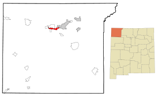
Adams County is a rural county in the state of Idaho. As of the 2020 census, the county had a population of 4,379, making it the sixth-least populous county in Idaho. The county seat and largest city is Council. Established in 1911, the county was named for second U.S. President John Adams.

<span class="mw-page-title-main">San Juan County, New Mexico</span> County in New Mexico, United States

San Juan County is located in the U.S. state of New Mexico. As of the 2020 census, the population was 121,661 making it the fifth-most populous county in New Mexico. Its county seat is Aztec. The county was created in 1887.

<span class="mw-page-title-main">Washington County, Idaho</span> County in Idaho, United States

Washington County is a county in the U.S. state of Idaho. As of the 2020 census, the population was 10,500. The county seat and largest city is Weiser, with over half of the county's population. The county was established in 1879 when Idaho was a territory and named after U.S. President George Washington.

<span class="mw-page-title-main">Valley County, Idaho</span> County in Idaho, United States

Valley County is a rural county located in the U.S. state of Idaho. As of the 2020 census, the population was 11,746. The county seat is Cascade, and the largest city is McCall. Established in 1917, it was named after the Long Valley of the North Fork of the Payette River, which extends over 30 miles (50 km) from Payette Lake at McCall south to Cascade to Round Valley. The valley was formerly a summer pasture for livestock from the Boise Valley. Since the completion of the Cascade Dam in 1948, much of the northern valley has been covered by the Cascade Reservoir.

<span class="mw-page-title-main">Power County, Idaho</span> County in Idaho, United States

Power County is a county located in the U.S. state of Idaho. As of the 2020 Census, the county had a population of 7,878. The county seat and largest city is American Falls. The county was created by the Idaho Legislature on January 30, 1913, by a partition of Cassia County. It is named for an early hydroelectric power plant (1902) at the American Falls.

<span class="mw-page-title-main">Gem County, Idaho</span> County in Idaho, United States

Gem County is a county in the U.S. state of Idaho. As of the 2020 census, the population was 19,123. The county seat and largest city is Emmett.

<span class="mw-page-title-main">Canyon County, Idaho</span> County in Idaho, United States

Canyon County is located in the U.S. state of Idaho. As of the 2020 Census, the population was 231,105, which by 2022 was estimated to have risen to 251,065. making it the second-most populous county in Idaho. The county seat is Caldwell, and its largest city is Nampa. Canyon County is part of the Boise metropolitan area.

<span class="mw-page-title-main">Boise County, Idaho</span> County in Idaho, United States

Boise County is a rural mountain county in the U.S. state of Idaho. As of the 2020 United States Census, the population was 7,610. The county seat is historic Idaho City, which is connected through a series of paved and unpaved roads to Lowman, Centerville, Placerville, Pioneerville, Star Ranch, Crouch, Garden Valley, and Horseshoe Bend.

<span class="mw-page-title-main">New Meadows, Idaho</span> City in Idaho, United States

New Meadows is a rural city in Adams County, Idaho, United States, at the southern and upper end of the Meadows Valley, on the Little Salmon River. Located in the west central part of the state, just south of the 45th parallel, the population was 496 at the 2010 census, down from 533 in 2000. New Meadows is located at the junction of the primary north–south highway in the state, U.S. Route 95, and State Highway 55, which connects it with McCall and Boise.

<span class="mw-page-title-main">Horseshoe Bend, Idaho</span> City in Idaho, United States

Horseshoe Bend is the largest city in rural Boise County, in the southwestern part of the U.S. state of Idaho. Its population of 707 at the 2010 census was the largest in the county, though down from 770 in 2000.

<span class="mw-page-title-main">Emmett, Idaho</span> City in Idaho, United States

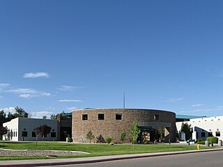
Emmett is a city in Gem County, Idaho, United States. The population was 6,557 at the 2010 census, up from 5,490 in 2000. It is the county seat and the only city in the county. Emmett is part of the Boise−Nampa, Idaho Metropolitan Statistical Area.

<span class="mw-page-title-main">Fruitland, Idaho</span> City in Payette County, Idaho, United States

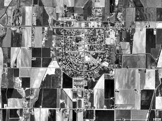
Fruitland is a city along the Snake and Payette rivers in Payette County, Idaho, United States. It lies along U.S. Route 95 in the Treasure Valley of southwest Idaho, about 50 miles (80 km) west of Boise on the border with Oregon. It is part of the Ontario Micropolitan Area. Fruitland is named after apple orchards that surround the community, and its slogan is "The Big Apple of Idaho."

<span class="mw-page-title-main">New Plymouth, Idaho</span> City in Idaho, United States

New Plymouth is a city in Payette County, Idaho. The population was 1,538 at the 2010 census, up from 1400 in 2000. It was incorporated on February 15, 1896. It is the host of the annual Payette County Fair and rodeo.

<span class="mw-page-title-main">Payette, Idaho</span> City in Idaho, United States

Payette is a city in and the county seat of Payette County, Idaho, United States. The population was 7,433 at the 2010 census. It is part of the Ontario, OR−ID Micropolitan Statistical Area.

<span class="mw-page-title-main">Donnelly, Idaho</span> City in Idaho, United States

Donnelly is a city in rural Valley County, Idaho, United States. The population was 152 at the 2010 census.

<span class="mw-page-title-main">Cambridge, Idaho</span> City in Idaho, United States

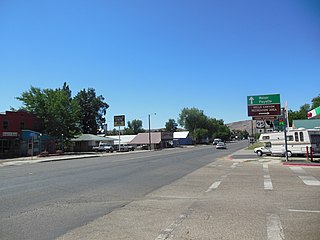
Cambridge is a city in Washington County, Idaho, United States. The population was 328 at the 2010 census, down from 360 in 2000. It is the second largest city in the county, behind the significantly larger Weiser, the county seat.

<span class="mw-page-title-main">Fruitland, Iowa</span> City in Iowa, United States

Fruitland is a city in Muscatine County, Iowa, United States. The population was 963 at the time of the 2020 census. It is part of the Muscatine Micropolitan Statistical Area.

<span class="mw-page-title-main">Fruitland, Maryland</span> City in Maryland, United States

Fruitland is a city in Wicomico County, Maryland, United States. The population was 4,866 at the 2010 census. It is included in the Salisbury, Maryland-Delaware Metropolitan Statistical Area.

<span class="mw-page-title-main">Nenahnezad, New Mexico</span> CDP in New Mexico, United States

Nenahnezad is a census-designated place (CDP) in San Juan County, New Mexico, United States. The population was 726 at the 2000 census. Nenahnezad is a Chapter community just to the south of Fruitland, between the towns of Farmington and Shiprock. It is part of the Farmington Metropolitan Statistical Area.

<span class="mw-page-title-main">Upper Fruitland, New Mexico</span> CDP in New Mexico, United States

Upper Fruitland is a census-designated place (CDP) in San Juan County, New Mexico, United States. The population was 1,664 at the 2000 census. It is part of the Farmington Metropolitan Statistical Area.

References

  1. "Payette County, Idaho". United States Census Bureau . Retrieved June 25, 2023.
  2. "Find a County". National Association of Counties. Archived from the original on May 31, 2011. Retrieved June 7, 2011.
  3. Gilmore, May (May 10, 1962). "Payette's land is rich with history". Lewiston Morning Tribune. (Idaho). p. 8, section2.
  4. "US Gazetteer files: 2010, 2000, and 1990". United States Census Bureau. February 12, 2011. Retrieved April 23, 2011.
  5. "Annual Estimates of the Resident Population for Counties: April 1, 2020 to July 1, 2023". United States Census Bureau. Retrieved March 31, 2024.
  6. "U.S. Decennial Census". United States Census Bureau. Retrieved July 1, 2014.
  7. "Historical Census Browser". University of Virginia Library. Retrieved July 1, 2014.
  8. "Population of Counties by Decennial Census: 1900 to 1990". United States Census Bureau. Retrieved July 1, 2014.
  9. "Census 2000 PHC-T-4. Ranking Tables for Counties: 1990 and 2000" (PDF). United States Census Bureau. Archived (PDF) from the original on March 27, 2010. Retrieved July 1, 2014.
  10. "State & County QuickFacts". United States Census Bureau. Archived from the original on July 17, 2011. Retrieved July 1, 2014.
  11. "U.S. Census website". United States Census Bureau . Retrieved January 31, 2008.
  12. 1 2 3 "DP-1 Profile of General Population and Housing Characteristics: 2010 Demographic Profile Data". United States Census Bureau. Archived from the original on February 13, 2020. Retrieved January 9, 2016.
  13. "Population, Housing Units, Area, and Density: 2010 - County". United States Census Bureau. Archived from the original on February 13, 2020. Retrieved January 9, 2016.
  14. "DP02 SELECTED SOCIAL CHARACTERISTICS IN THE UNITED STATES – 2006-2010 American Community Survey 5-Year Estimates". United States Census Bureau. Archived from the original on February 13, 2020. Retrieved January 9, 2016.
  15. "DP03 SELECTED ECONOMIC CHARACTERISTICS – 2006-2010 American Community Survey 5-Year Estimates". United States Census Bureau. Archived from the original on February 13, 2020. Retrieved January 9, 2016.
  16. "Explore Census Data". data.census.gov. Retrieved March 26, 2022.
  17. "Explore Census Data". data.census.gov. Retrieved March 26, 2022.
  18. "2020 CENSUS - SCHOOL DISTRICT REFERENCE MAP: Payette County, ID" (PDF). U.S. Census Bureau . Retrieved March 12, 2024. - Text list
  19. "College of Western Idaho, pg. 1-77" (PDF). Idaho Legislature. January 26, 2022. Retrieved March 12, 2024. - See the map. Also see area 3 in: "TITLE 33 EDUCATION CHAPTER 21 JUNIOR COLLEGES". Idaho Legislature . Retrieved March 12, 2024.
  20. Leip, David. "Dave Leip's Atlas of U.S. Presidential Elections". uselectionatlas.org. Retrieved April 4, 2018.

44°01′N116°46′W / 44.01°N 116.76°W / 44.01; -116.76