Washington County, Idaho

Last updated

Washington County
Washington County Courthouse, Weiser.jpg
Washington County, Idaho seal.png
Map of Idaho highlighting Washington County.svg
Location within the U.S. state of Idaho
Idaho in United States.svg
Idaho's location within the U.S.
Coordinates: 44°27′N116°47′W / 44.45°N 116.78°W / 44.45; -116.78
CountryFlag of the United States.svg United States
StateFlag of Idaho.svg  Idaho
FoundedFebruary 20, 1879
Named for George Washington
Seat Weiser
Largest cityWeiser
Area
  Total1,474 sq mi (3,820 km2)
  Land1,453 sq mi (3,760 km2)
  Water21 sq mi (50 km2)  1.4%
Population
 (2020)
  Total10,500
  Density7.1/sq mi (2.8/km2)
Time zone UTC−7 (Mountain)
  Summer (DST) UTC−6 (MDT)
Congressional district 1st
Website www.co.washington.id.us

Washington County is a county in the U.S. state of Idaho. As of the 2020 census, the population was 10,500. [1] The county seat and largest city is Weiser, [2] with over half of the county's population. The county was established in 1879 when Idaho was a territory and named after U.S. President George Washington.

Contents

Geography

According to the U.S. Census Bureau, the county has a total area of 1,474 square miles (3,820 km2), of which 1,453 square miles (3,760 km2) is land and 21 square miles (54 km2) (1.4%) is water. [3]

Adjacent counties

Major highways

National protected areas

Rivers

Reservoirs

Demographics

Historical population
CensusPop.Note
1880 879
1890 3,836336.4%
1900 6,88279.4%
1910 11,10161.3%
1920 9,424−15.1%
1930 7,962−15.5%
1940 8,85311.2%
1950 8,576−3.1%
1960 8,378−2.3%
1970 7,633−8.9%
1980 8,80315.3%
1990 8,550−2.9%
2000 9,97716.7%
2010 10,1982.2%
2020 10,5003.0%
2023 (est.)11,425 [4] 8.8%
U.S. Decennial Census [5]
1790–1960, [6] 1900–1990, [7]
1990–2000, [8] 2010 [9]

2020 census

As of the census [10] of 2020, there were 10,500 people in 4,112 households living in the county. The population density was 7 people per square mile (2.7 people/km2). There were 4,138 housing units at an average density of 3 units per square mile (1.2 units/km2). The racial makeup of the county was 87.61% White, 1.03% Asian, 0.66% Native American, 0.10% Black or African American, 0.07% Pacific Islander, 8.17% from other races, and 2.36% from two or more races. 13.75% of the population were Hispanic or Latino of any race. 15.7% were of German, 14.3% English, 10.1% American and 7.7% Irish ancestry.

There were 3,762 households, out of which 32.7% had children under the age of 18 living with them, 60.7% were married couples living together, 8.2% had a female householder with no husband present, and 27.2% were non-families. 23.5% of all households were made up of individuals, and 13.30% had someone living alone who was 65 years of age or older. The average household size was 2.61 and the average family size was 3.10.

In the county, the population was spread out, with 27.4% under the age of 18, 7.20% from 18 to 24, 23.4% from 25 to 44, 24.3% from 45 to 64, and 17.70% who were 65 years of age or older. The median age was 39 years. For every 100 females there were 95.80 males. For every 100 females age 18 and over, there were 93.0 males.

The median income for a household in the county was $30,625, and the median income for a family was $35,542. Males had a median income of $27,222 versus $18,053 for females. The per capita income for the county was $15,464. About 10.00% of families and 13.30% of the population were below the poverty line, including 16.60% of those under age 18 and 9.90% of those age 65 or over.

2010 census

As of the 2010 United States Census, there were 10,198 people, 4,034 households, and 2,803 families living in the county. [11] The population density was 7.0 inhabitants per square mile (2.7/km2). There were 4,529 housing units at an average density of 3.1 units per square mile (1.2 units/km2). [12] The racial makeup of the county was 86.6% white, 1.0% American Indian, 0.9% Asian, 0.2% black or African American, 9.1% from other races, and 2.2% from two or more races. Those of Hispanic or Latino origin made up 16.8% of the population. [11] In terms of ancestry, 20.0% were English, 18.2% were German, 14.8% were Irish, and 9.6% were American. [13]

Of the 4,034 households, 30.4% had children under the age of 18 living with them, 54.9% were married couples living together, 9.7% had a female householder with no husband present, 30.5% were non-families, and 25.8% of all households were made up of individuals. The average household size was 2.50 and the average family size was 2.99. The median age was 43.6 years. [11]

The median income for a household in the county was $36,542 and the median income for a family was $46,970. Males had a median income of $36,765 versus $26,406 for females. The per capita income for the county was $20,015. About 10.9% of families and 13.2% of the population were below the poverty line, including 15.6% of those under age 18 and 9.6% of those age 65 or over. [14]

2020 census

Note: the US Census treats Hispanic/Latino as an ethnic category. This table excludes Latinos from the racial categories and assigns them to a separate category. Hispanics/Latinos can be of any race.

Washington County racial composition
(NH = Non-Hispanic) [15] [16]
RacePop 2010Pop 2020% 2010% 2020
White (NH)8,1668,11880.07%77.31%
Black or African American (NH)10170.1%0.16%
Native American or Alaska Native (NH)75740.74%0.7%
Asian (NH)90810.88%0.77%
Pacific Islander (NH)370.03%0.07%
Some Other Race (NH)12530.12%0.5%
Mixed/Multi-Racial (NH)1264881.24%4.65%
Hispanic or Latino 1,7161,66216.83%15.83%
Total10,19810,500

As of the 2020 United States census, there were 10,500 people, 4,035 households, and 2,708 families residing in the county.

Education

The county is served by three school districts based in the county: [17]

Additionally Payette Joint School District 371 includes a portion of Washington County. [20]

Washington County is in the area (but not the taxing region) of the College of Western Idaho, which has its main campus in Nampa. [21]

Communities

Cities

Politics

United States presidential election results for Washington County, Idaho [22]
Year Republican Democratic Third party
No.%No.%No.%
2020 4,15477.70%1,07320.07%1192.23%
2016 3,28373.69%77617.42%3968.89%
2012 3,12872.22%1,10425.49%992.29%
2008 3,16870.31%1,24127.54%972.15%
2004 3,27475.11%1,03323.70%521.19%
2000 2,89971.23%98024.08%1914.69%
1996 2,31854.90%1,31431.12%59013.97%
1992 1,80242.09%1,12226.21%1,35731.70%
1988 2,38061.98%1,35935.39%1012.63%
1984 3,01571.99%1,11926.72%541.29%
1980 2,91563.58%1,42130.99%2495.43%
1976 2,04453.47%1,69344.28%862.25%
1972 2,26461.99%93525.60%45312.40%
1968 2,02057.65%1,03329.48%45112.87%
1964 1,73046.99%1,95253.01%00.00%
1960 2,25155.86%1,77944.14%00.00%
1956 2,27257.89%1,65342.11%00.00%
1952 2,61664.91%1,41135.01%30.07%
1948 1,71349.21%1,70048.84%681.95%
1944 2,00251.95%1,84947.98%30.08%
1940 1,90345.27%2,29654.61%50.12%
1936 1,23434.70%2,14760.38%1754.92%
1932 1,21334.65%2,12260.61%1664.74%
1928 1,97366.39%97432.77%250.84%
1924 1,18341.33%62321.77%1,05636.90%
1920 1,86459.59%1,26440.41%00.00%
1916 1,54544.43%1,80251.83%1303.74%
1912 72425.32%1,06537.25%1,07037.43%
1908 1,81951.56%1,45241.16%2577.28%
1904 1,89460.69%93129.83%2969.48%
1900 1,19446.95%1,34953.05%00.00%

See also

Related Research Articles

<span class="mw-page-title-main">Adams County, Idaho</span> County in Idaho, United States

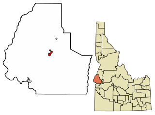
Adams County is a rural county in the state of Idaho. As of the 2020 census, the county had a population of 4,379, making it the sixth-least populous county in Idaho. The county seat and largest city is Council. Established in 1911, the county was named for second U.S. President John Adams.

<span class="mw-page-title-main">Malheur County, Oregon</span> County in Oregon, United States

Malheur County is one of the 36 counties in the U.S. state of Oregon. As of the 2020 census, the population was 31,571. Its county seat is Vale, and its largest city is Ontario. The county was named after the Malheur River, which runs through the county. The word "malheur" is French for misfortune or tragedy. Malheur County is included in the Ontario, Oregon Micropolitan Statistical Area, which is also included in the Boise Combined Statistical Area. It is included in the eight-county definition of Eastern Oregon.

<span class="mw-page-title-main">Valley County, Idaho</span> County in Idaho, United States

Valley County is a rural county located in the U.S. state of Idaho. As of the 2020 census, the population was 11,746. The county seat is Cascade, and the largest city is McCall. Established in 1917, it was named after the Long Valley of the North Fork of the Payette River, which extends over 30 miles (50 km) from Payette Lake at McCall south to Cascade to Round Valley. The valley was formerly a summer pasture for livestock from the Boise Valley. Since the completion of the Cascade Dam in 1948, much of the northern valley has been covered by the Cascade Reservoir.

<span class="mw-page-title-main">Payette County, Idaho</span> County in Idaho, United States

Payette County is a county located in Idaho in the United States of America. As of the 2020 census, the population was 25,386. The county seat and largest city is Payette.

<span class="mw-page-title-main">Idaho County, Idaho</span> County in Idaho, United States

Idaho County is a county in the U.S. state of Idaho, and the largest by area in the state. As of the 2020 census, the population was 16,541. The county seat is Grangeville. Previous county seats of the area were Florence (1864–68), Washington (1868–75), and Mount Idaho (1875–1902).

<span class="mw-page-title-main">Gem County, Idaho</span> County in Idaho, United States

Gem County is a county in the U.S. state of Idaho. As of the 2020 census, the population was 19,123. The county seat and largest city is Emmett.

<span class="mw-page-title-main">Canyon County, Idaho</span> County in Idaho, United States

Canyon County is located in the U.S. state of Idaho. As of the 2020 Census, the population was 231,105, which by 2022 was estimated to have risen to 251,065. making it the second-most populous county in Idaho. The county seat is Caldwell, and its largest city is Nampa. Canyon County is part of the Boise metropolitan area.

<span class="mw-page-title-main">Boise County, Idaho</span> County in Idaho, United States

Boise County is a rural mountain county in the U.S. state of Idaho. As of the 2020 United States Census, the population was 7,610. The county seat is historic Idaho City, which is connected through a series of paved and unpaved roads to Lowman, Centerville, Placerville, Pioneerville, Star Ranch, Crouch, Garden Valley, and Horseshoe Bend.

<span class="mw-page-title-main">Ada County, Idaho</span> County in Idaho, United States

Ada County is located in the southwestern part of Idaho, United States. As of the 2020 census, the county had a population of 494,967, which by 2022 was estimated to have risen to 518,907. Ada County is by far the state's most populous county; it is home to 26.8% of the state's population. The county seat and largest city is Boise, which is also the state capital. Ada County is included in the Boise metropolitan area. The Ada County Highway District has jurisdiction over all the local county and city streets, except for private roads and state roads. In the interior Pacific Northwest east of the Cascade Range, Ada County ranks second in population, behind Spokane County, Washington.

<span class="mw-page-title-main">Council, Idaho</span> City in Idaho, United States

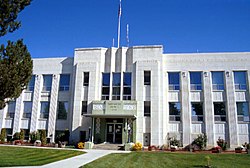
Council is a city in and the county seat of Adams County, Idaho, United States. The population was 839 at the 2010 census.

<span class="mw-page-title-main">New Meadows, Idaho</span> City in Idaho, United States

New Meadows is a rural city in Adams County, Idaho, United States, at the southern and upper end of the Meadows Valley, on the Little Salmon River. Located in the west central part of the state, just south of the 45th parallel, the population was 496 at the 2010 census, down from 533 in 2000. New Meadows is located at the junction of the primary north–south highway in the state, U.S. Route 95, and State Highway 55, which connects it with McCall and Boise.

<span class="mw-page-title-main">Horseshoe Bend, Idaho</span> City in Idaho, United States

Horseshoe Bend is the largest city in rural Boise County, in the southwestern part of the U.S. state of Idaho. Its population of 707 at the 2010 census was the largest in the county, though down from 770 in 2000.

<span class="mw-page-title-main">Emmett, Idaho</span> City in Idaho, United States

Emmett is a city in Gem County, Idaho, United States. The population was 6,557 at the 2010 census, up from 5,490 in 2000. It is the county seat and the only city in the county. Emmett is part of the Boise−Nampa, Idaho Metropolitan Statistical Area.

<span class="mw-page-title-main">Fruitland, Idaho</span> City in Payette County, Idaho, United States

Fruitland is a city along the Snake and Payette rivers in Payette County, Idaho, United States. It lies along U.S. Route 95 in the Treasure Valley of southwest Idaho, about 50 miles (80 km) west of Boise on the border with Oregon. It is part of the Ontario Micropolitan Area. Fruitland is named after apple orchards that surround the community, and its slogan is "The Big Apple of Idaho."

<span class="mw-page-title-main">New Plymouth, Idaho</span> City in Idaho, United States

New Plymouth is a city in Payette County, Idaho. The population was 1,538 at the 2010 census, up from 1400 in 2000. It was incorporated on February 15, 1896. It is the host of the annual Payette County Fair and rodeo.

<span class="mw-page-title-main">Payette, Idaho</span> City in Idaho, United States

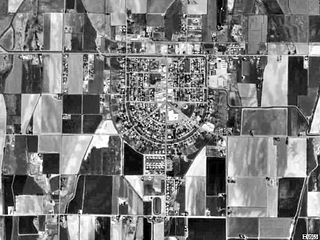
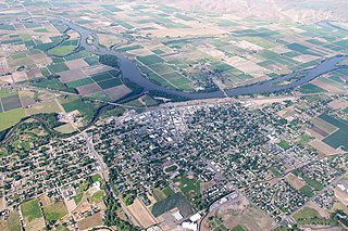
Payette is a city in and the county seat of Payette County, Idaho, United States. The population was 7,433 at the 2010 census. It is part of the Ontario, OR−ID Micropolitan Statistical Area.

<span class="mw-page-title-main">Donnelly, Idaho</span> City in Idaho, United States

Donnelly is a city in rural Valley County, Idaho, United States. The population was 152 at the 2010 census.

<span class="mw-page-title-main">Cambridge, Idaho</span> City in Idaho, United States

Cambridge is a city in Washington County, Idaho, United States. The population was 328 at the 2010 census, down from 360 in 2000. It is the second largest city in the county, behind the significantly larger Weiser, the county seat.

<span class="mw-page-title-main">Midvale, Idaho</span> City in Idaho, United States

Midvale is a city in Washington County, Idaho, United States. The population was 171 at the 2010 census, rising to 193 as of 2020.

<span class="mw-page-title-main">Weiser, Idaho</span> City in Idaho, United States

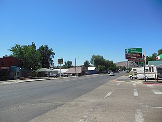
Weiser is a city in the rural western part of the U.S. state of Idaho and the county seat of Washington County. With its mild climate, the city supports farm, orchard, and livestock endeavors in the vicinity. The city sits at the confluence of the Weiser River with the great Snake River, which marks the border with Oregon. The population was 5,507 at the 2010 census.

References

  1. "Washington County, Idaho". United States Census Bureau . Retrieved June 25, 2023.
  2. "Find a County". National Association of Counties. Retrieved June 7, 2011.
  3. "US Gazetteer files: 2010, 2000, and 1990". United States Census Bureau. February 12, 2011. Retrieved April 23, 2011.
  4. "Annual Estimates of the Resident Population for Counties: April 1, 2020 to July 1, 2023". United States Census Bureau. Retrieved March 31, 2024.
  5. "U.S. Decennial Census". United States Census Bureau. Retrieved July 1, 2014.
  6. "Historical Census Browser". University of Virginia Library. Retrieved July 1, 2014.
  7. "Population of Counties by Decennial Census: 1900 to 1990". United States Census Bureau. Retrieved July 1, 2014.
  8. "Census 2000 PHC-T-4. Ranking Tables for Counties: 1990 and 2000" (PDF). United States Census Bureau. Archived (PDF) from the original on March 27, 2010. Retrieved July 1, 2014.
  9. "State & County QuickFacts". United States Census Bureau. Retrieved July 1, 2014.
  10. "U.S. Census website". United States Census Bureau . Retrieved December 1, 2023.
  11. 1 2 3 "DP-1 Profile of General Population and Housing Characteristics: 2010 Demographic Profile Data". United States Census Bureau. Archived from the original on February 13, 2020. Retrieved January 9, 2016.
  12. "Population, Housing Units, Area, and Density: 2010 - County". United States Census Bureau. Archived from the original on February 13, 2020. Retrieved January 9, 2016.
  13. "DP02 SELECTED SOCIAL CHARACTERISTICS IN THE UNITED STATES – 2006-2010 American Community Survey 5-Year Estimates". United States Census Bureau. Archived from the original on February 13, 2020. Retrieved January 9, 2016.
  14. "DP03 SELECTED ECONOMIC CHARACTERISTICS – 2006-2010 American Community Survey 5-Year Estimates". United States Census Bureau. Archived from the original on February 13, 2020. Retrieved January 9, 2016.
  15. "Explore Census Data". data.census.gov. Retrieved March 15, 2022.
  16. "Explore Census Data". data.census.gov. Retrieved March 15, 2022.
  17. 1 2 Education, Idaho State Department of (April 15, 2009). "Idaho Educational Directory 2008-09" (PDF). Retrieved May 26, 2009.
  18. District, Weiser School (2008). "Welcome to Weiser Schools!" . Retrieved May 26, 2009.
  19. District, Midvale School (2009). "Home" . Retrieved May 26, 2009.
  20. "2020 CENSUS - SCHOOL DISTRICT REFERENCE MAP: Washington County, ID" (PDF). U.S. Census Bureau. Archived (PDF) from the original on July 29, 2022. Retrieved July 29, 2022. - Text list
  21. "College of Western Idaho, pg. 1-77" (PDF). Idaho Legislature. January 26, 2022. Retrieved March 12, 2024. - See the map. Also see area 3 in: "TITLE 33 EDUCATION CHAPTER 21 JUNIOR COLLEGES". Idaho Legislature . Retrieved March 12, 2024.
  22. Leip, David. "Dave Leip's Atlas of U.S. Presidential Elections". uselectionatlas.org. Retrieved April 4, 2018.

44°27′N116°47′W / 44.45°N 116.78°W / 44.45; -116.78