New Meadows, Idaho

Last updated

New Meadows, Idaho
Pacific and Idaho Northern Railroad Depot, New Meadows, Idaho.jpg
PIN Railroad Depot in 2007
Adams County Idaho Incorporated and Unincorporated areas New Meadows Highlighted 1656890.svg
Location of New Meadows in Adams County, Idaho.
Coordinates: 44°58′13″N116°17′7″W / 44.97028°N 116.28528°W / 44.97028; -116.28528
Country United States
State Idaho
County Adams
Government
  MayorJulie Good
Area
[1]
  Total0.59 sq mi (1.54 km2)
  Land0.58 sq mi (1.51 km2)
  Water0.01 sq mi (0.03 km2)
Elevation
3,868 ft (1,179 m)
Population
 (2010) [2]
  Total496
  Estimate 
(2019) [3]
537
  Density919.52/sq mi (354.78/km2)
Time zone UTC-7 (Mountain (MST))
  Summer (DST) UTC-6 (MDT)
ZIP code
83654
Area code(s) 208, 986
FIPS code 16-56890
GNIS feature ID0387535
Website www.newmeadowsidaho.us

New Meadows is a rural city in Adams County, Idaho, United States, at the southern and upper end of the Meadows Valley, on the Little Salmon River. Located in the west central part of the state, just south of the 45th parallel, the population was 496 at the 2010 census, down from 533 in 2000. New Meadows is located at the junction of the primary north–south highway in the state, U.S. Route 95, and State Highway 55, which connects it with McCall and Boise.

Contents

History

Pacific and Idaho Northern Railroad in 1930 Pacific and Idaho Northern Railroad route.jpg
Pacific and Idaho Northern Railroad in 1930

Prior to the establishment of Adams County in 1911, Meadows was in Washington County; The Meadows Eagle newspaper served the community, and C. A. Hackney was the publisher. [4]

The Pacific and Idaho Northern (PIN) Railroad ran from Weiser to an area about two miles (3.2 km) from Meadows, the site of modern-day New Meadows founded in 1911. The city of New Meadows hosts the last surviving remnants of the PIN; without the railroad, New Meadows would arguably not have existed.

The depot was built in 1910 and served as the northern end of the PIN Railroad. It is a significant cultural and historical resource in the Payette River Scenic Byway corridor in the city of New Meadows, at the junction of US-95 and state highway 55. It is listed on the National Register of Historic Places. [5] The depot is an asset for the community of New Meadows and currently functions as a community center for the local area. It hosted the Barn Again! Smithsonian Institution traveling exhibition in 2005, [6] and represents early twentieth century efforts to create a north–south railroad for Idaho. Though the efforts ultimately failed, the PIN Railroad served an important function as a "farm-to-market" railroad until 1940, and then as a timber railroad for local timber outfits.

The Union Pacific acquired the line in 1936 and in 1979 abandoned the northern end of the line, from the Tamarack sawmill site north of Council to New Meadows, along US-95. The depot was a functioning facility until 1972. In 1978, ACHS acquired the title to the PIN Depot to preserve it as a repository for the history of Adams County. [7] Since 2000, the building has been preserved from immediate deterioration; the foundation has been restored and the building has a new roof.

Education

The only school in New Meadows is the Meadows Valley School, which houses all thirteen grades, K-12. The school mascot is the mountaineer, and the school colors are orange and black. [8]

Recreation

Two established alpine ski areas, Brundage Mountain and the Little Ski Hill are less than ten miles (16 km) to the east, both on the west side of the Valley/Adams county line. The MeadowCreek golf resort (originally "Kimberland Meadows") [9] is a few miles northwest of town. [10] Payette Lake and the surrounding areas in McCall offer numerous recreational opportunities, and further north along US-95 is Riggins, the gateway to the Salmon River and the Seven Devils Mountains. Five miles (8.0 km) north of New Meadows is Zim's Hot Springs.

Highways

New Meadows is approximately 115 miles (185 km) north of Boise, accessed via State Highway 55, the Payette River Scenic Byway, a designated national scenic byway. It heads north from Eagle in Ada County to Horseshoe Bend in Boise County, and climbs the whitewater of the Payette River to Cascade and McCall in Valley County. The route turns west at Payette Lake in McCall and ends at New Meadows at the junction with U.S. Route 95. [11]

Geography

New Meadows is located at 44°58′13″N116°17′7″W / 44.97028°N 116.28528°W / 44.97028; -116.28528 (44.970405, -116.285283), [12] at an elevation of 3,868 feet (1,179 m) above sea level. [13]

According to the United States Census Bureau, the city has a total area of 0.53 square miles (1.37 km2), of which, 0.52 square miles (1.35 km2) is land and 0.01 square miles (0.026 km2) is water. [14]

Climate

According to the Köppen Climate Classification system, New Meadows has a warm-summer mediterranean continental climate, abbreviated "Dsb" on climate maps. The hottest temperature recorded in New Meadows was 104 °F (40.0 °C) on August 9, 1906, July 19, 1960, and July 13, 2002, while the coldest temperature recorded was −49 °F (−45.0 °C) on December 13, 1919. [15]

Climate data for New Meadows, Idaho, 1991–2020 normals, extremes 1905–2020
MonthJanFebMarAprMayJunJulAugSepOctNovDecYear
Record high °F (°C)56
(13)
62
(17)
73
(23)
87
(31)
93
(34)
101
(38)
104
(40)
104
(40)
97
(36)
89
(32)
72
(22)
64
(18)
104
(40)
Mean maximum °F (°C)42.0
(5.6)
47.5
(8.6)
60.4
(15.8)
72.5
(22.5)
81.3
(27.4)
88.9
(31.6)
95.9
(35.5)
95.4
(35.2)
89.8
(32.1)
77.7
(25.4)
58.5
(14.7)
44.1
(6.7)
96.9
(36.1)
Mean daily maximum °F (°C)30.0
(−1.1)
36.2
(2.3)
45.1
(7.3)
54.6
(12.6)
63.8
(17.7)
72.2
(22.3)
84.8
(29.3)
84.6
(29.2)
74.7
(23.7)
57.9
(14.4)
41.9
(5.5)
30.7
(−0.7)
56.4
(13.5)
Daily mean °F (°C)19.7
(−6.8)
24.1
(−4.4)
33.0
(0.6)
40.9
(4.9)
48.6
(9.2)
55.7
(13.2)
64.0
(17.8)
62.7
(17.1)
53.8
(12.1)
42.0
(5.6)
30.6
(−0.8)
21.7
(−5.7)
41.4
(5.2)
Mean daily minimum °F (°C)9.4
(−12.6)
12.1
(−11.1)
20.8
(−6.2)
27.2
(−2.7)
33.4
(0.8)
39.1
(3.9)
43.3
(6.3)
40.7
(4.8)
32.9
(0.5)
25.2
(−3.8)
19.3
(−7.1)
12.6
(−10.8)
26.3
(−3.2)
Mean minimum °F (°C)−16.1
(−26.7)
−10.4
(−23.6)
1.8
(−16.8)
16.1
(−8.8)
20.9
(−6.2)
28.3
(−2.1)
33.2
(0.7)
30.5
(−0.8)
21.9
(−5.6)
12.3
(−10.9)
1.0
(−17.2)
−13.1
(−25.1)
−22.2
(−30.1)
Record low °F (°C)−43
(−42)
−44
(−42)
−29
(−34)
−2
(−19)
12
(−11)
19
(−7)
20
(−7)
18
(−8)
11
(−12)
−7
(−22)
−34
(−37)
−49
(−45)
−49
(−45)
Average precipitation inches (mm)2.85
(72)
2.00
(51)
2.51
(64)
2.01
(51)
2.35
(60)
2.08
(53)
0.70
(18)
0.56
(14)
1.01
(26)
1.83
(46)
2.55
(65)
4.05
(103)
24.50
(622)
Average snowfall inches (cm)18.0
(46)
10.5
(27)
3.9
(9.9)
0.9
(2.3)
0.1
(0.25)
0.0
(0.0)
0.0
(0.0)
0.0
(0.0)
0.0
(0.0)
0.2
(0.51)
4.4
(11)
18.6
(47)
56.6
(143.96)
Source 1: NOAA [16]
Source 2: National Weather Service [15]

Demographics

Historical population
CensusPop.Note
1920 141
1930 22056.0%
1940 26420.0%
1950 621135.2%
1960 6474.2%
1970 605−6.5%
1980 576−4.8%
1990 534−7.3%
2000 533−0.2%
2010 496−6.9%
2019 (est.)537 [3] 8.3%
U.S. Decennial Census [17]

2010 census

As of the census [2] of 2010, there were 496 people, 201 households, and 136 families residing in the city. The population density was 953.8 inhabitants per square mile (368.3/km2). There were 264 housing units at an average density of 507.7 per square mile (196.0/km2). The racial makeup of the city was 95.4% White, 0.4% Native American, 3.2% from other races, and 1.0% from two or more races. Hispanic or Latino of any race were 4.8% of the population.

There were 201 households, of which 34.3% had children under the age of 18 living with them, 51.2% were married couples living together, 10.0% had a female householder with no husband present, 6.5% had a male householder with no wife present, and 32.3% were non-families. 24.9% of all households were made up of individuals, and 7% had someone living alone who was 65 years of age or older. The average household size was 2.46 and the average family size was 2.91.

The median age in the city was 35.9 years. 27.2% of residents were under the age of 18; 8.1% were between the ages of 18 and 24; 25.4% were from 25 to 44; 28.5% were from 45 to 64; and 10.9% were 65 years of age or older. The gender makeup of the city was 51.2% male and 48.8% female.

2000 census

As of the census [18] of 2000, there were 533 people, 208 households, and 143 families residing in the city. The population density was 1,089.1 inhabitants per square mile (420.5/km2). There were 262 housing units at an average density of 535.4 per square mile (206.7/km2). The racial makeup of the city was 97.19% White, 0.19% African American, 1.31% Native American, 0.38% from other races, and 0.94% from two or more races. Hispanic or Latino of any race were 0.75% of the population.

There were 208 households, out of which 34.6% had children under the age of 18 living with them, 57.7% were married couples living together, 7.7% had a female householder with no husband present, and 30.8% were non-families. 24.5% of all households were made up of individuals, and 7.2% had someone living alone who was 65 years of age or older. The average household size was 2.56 and the average family size was 3.08.

In the city, the population was spread out, with 29.1% under the age of 18, 6.2% from 18 to 24, 30.8% from 25 to 44, 24.0% from 45 to 64, and 9.9% who were 65 years of age or older. The median age was 36 years. For every 100 females, there were 159.5 males. For every 100 females age 18 and over, there were 140.1 males.

The median income for a household in the city was $28,500, and the median income for a family was $31,042. Males had a median income of $30,000 versus $14,500 for females. The per capita income for the city was $11,884. About 16.2% of families and 16.4% of the population were below the poverty line, including 14.8% of those under age 18 and 5.0% of those age 65 or over.

Residents

See also

Related Research Articles

<span class="mw-page-title-main">Adams County, Idaho</span> County in Idaho, United States

Adams County is a rural county in the state of Idaho. As of the 2020 census, the county had a population of 4,379, making it the sixth-least populous county in Idaho. The county seat and largest city is Council. Established in 1911, the county was named for second U.S. President John Adams.

<span class="mw-page-title-main">Valley County, Idaho</span> County in Idaho, United States

Valley County is a rural county located in the U.S. state of Idaho. As of the 2020 census, the population was 11,746. The county seat is Cascade, and the largest city is McCall. Established in 1917, it was named after the Long Valley of the North Fork of the Payette River, which extends over 30 miles (50 km) from Payette Lake at McCall south to Cascade to Round Valley. The valley was formerly a summer pasture for livestock from the Boise Valley. Since the completion of the Cascade Dam in 1948, much of the northern valley has been covered by the Cascade Reservoir.

<span class="mw-page-title-main">Payette County, Idaho</span> County in Idaho, United States

Payette County is a county located in Idaho in the United States of America. As of the 2020 census, the population was 25,386. The county seat and largest city is Payette.

<span class="mw-page-title-main">Gem County, Idaho</span> County in Idaho, United States

Gem County is a county in the U.S. state of Idaho. As of the 2020 census, the population was 19,123. The county seat and largest city is Emmett.

<span class="mw-page-title-main">Canyon County, Idaho</span> County in Idaho, United States

Canyon County is located in the U.S. state of Idaho. As of the 2020 Census, the population was 231,105, which by 2022 was estimated to have risen to 251,065. making it the second-most populous county in Idaho. The county seat is Caldwell, and its largest city is Nampa. Canyon County is part of the Boise metropolitan area.

<span class="mw-page-title-main">Boise County, Idaho</span> County in Idaho, United States

Boise County is a rural mountain county in the U.S. state of Idaho. As of the 2020 United States Census, the population was 7,610. The county seat is historic Idaho City, which is connected through a series of paved and unpaved roads to Lowman, Centerville, Placerville, Pioneerville, Star Ranch, Crouch, Garden Valley, and Horseshoe Bend.

<span class="mw-page-title-main">Ada County, Idaho</span> County in Idaho, United States

Ada County is located in the southwestern part of Idaho, United States. As of the 2020 census, the county had a population of 494,967, which by 2022 was estimated to have risen to 518,907. Ada County is by far the state's most populous county; it is home to 26.8% of the state's population. The county seat and largest city is Boise, which is also the state capital. Ada County is included in the Boise metropolitan area. The Ada County Highway District has jurisdiction over all the local county and city streets, except for private roads and state roads. In the interior Pacific Northwest east of the Cascade Range, Ada County ranks second in population, behind Spokane County, Washington.

<span class="mw-page-title-main">Kuna, Idaho</span> City in Ada County, Idaho, United States

Kuna is a city in Ada County, Idaho. It is part of the Boise metropolitan area. The population was 24,011 at the time of the 2020 census.

<span class="mw-page-title-main">Horseshoe Bend, Idaho</span> City in Idaho, United States

Horseshoe Bend is the largest city in rural Boise County, in the southwestern part of the U.S. state of Idaho. Its population of 707 at the 2010 census was the largest in the county, though down from 770 in 2000.

<span class="mw-page-title-main">Idaho City, Idaho</span> Town in Idaho, United States

Idaho City is a town in, and the county seat of, Boise County, Idaho, United States, located about 36 miles (58 km) northeast of Boise. The population was 485 at the 2010 census, up from 458 in 2000.

<span class="mw-page-title-main">Orofino, Idaho</span> City in Idaho, United States

Orofino is a city in and the county seat of Clearwater County, Idaho, United States, along Orofino Creek and the north bank of the Clearwater River. It is the major city within the Nez Perce Indian Reservation. The population was 3,142 at the time of the 2010 census.

<span class="mw-page-title-main">Stanley, Idaho</span> Town in Idaho, United States

Stanley is a town in the Sawtooth Valley in Custer County, Idaho, United States. The population was 116 at the 2020 census; up from 63 in 2010. The center of population of Idaho in 2000 was located in Stanley.

<span class="mw-page-title-main">Emmett, Idaho</span> City in Idaho, United States

Emmett is a city in Gem County, Idaho, United States. The population was 6,557 at the 2010 census, up from 5,490 in 2000. It is the county seat and the only city in the county. Emmett is part of the Boise−Nampa, Idaho Metropolitan Statistical Area.

<span class="mw-page-title-main">Fruitland, Idaho</span> City in Payette County, Idaho, United States

Fruitland is a city along the Snake and Payette rivers in Payette County, Idaho, United States. It lies along U.S. Route 95 in the Treasure Valley of southwest Idaho, about 50 miles (80 km) west of Boise on the border with Oregon. It is part of the Ontario Micropolitan Area. Fruitland is named after apple orchards that surround the community, and its slogan is "The Big Apple of Idaho."

<span class="mw-page-title-main">Payette, Idaho</span> City in Idaho, United States

Payette is a city in and the county seat of Payette County, Idaho, United States. The population was 7,433 at the 2010 census. It is part of the Ontario, OR−ID Micropolitan Statistical Area.

<span class="mw-page-title-main">Donnelly, Idaho</span> City in Idaho, United States

Donnelly is a city in rural Valley County, Idaho, United States. The population was 152 at the 2010 census.

<span class="mw-page-title-main">McCall, Idaho</span> City in Idaho, United States

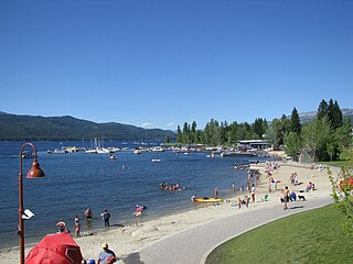
McCall is a resort town on the western edge of Valley County, Idaho, United States. Named after its founder, Tom McCall, it is situated on the southern shore of Payette Lake, near the center of the Payette National Forest. The population was 2,991 as of the 2010 census, up from 2,084 in 2000.

<span class="mw-page-title-main">Cambridge, Idaho</span> City in Idaho, United States

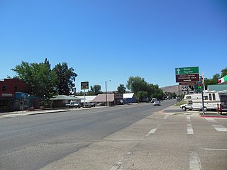
Cambridge is a city in Washington County, Idaho, United States. The population was 328 at the 2010 census, down from 360 in 2000. It is the second largest city in the county, behind the significantly larger Weiser, the county seat.

Lowman is a small unincorporated rural census-designated place in the western United States, located in Boise County, Idaho. It is nestled along the north bank of the South Fork of the Payette River in the central part of the state, at an elevation of 3,800 feet (1,160 m) above sea level. As of the 2010 census, its population was 42.

<span class="mw-page-title-main">Idaho State Highway 55</span> State highway in Idaho, United States

State Highway 55 (SH-55) is an Idaho highway from Marsing to New Meadows, connecting with US-95 at both ends.

References

  1. "2019 U.S. Gazetteer Files". United States Census Bureau. Retrieved July 9, 2020.
  2. 1 2 "U.S. Census website". United States Census Bureau . Retrieved December 18, 2012.
  3. 1 2 "Population and Housing Unit Estimates". United States Census Bureau. May 24, 2020. Retrieved May 27, 2020.
  4. "Meadows Eagle (Meadows, Washington County, Idaho) 1903-1919". Library of Congress .
  5. "National Register Information System". National Register of Historic Places . National Park Service. March 13, 2009.
  6. "Museum On Main Street; About". www.museumonmainstreet.org. Archived from the original on December 31, 2010.
  7. "Idaho for the Curious", by Cort Conley, ©1982, ISBN   0-9603566-3-0, p.580-584
  8. Meadows Valley School - accessed 2009-05-18 Archived June 9, 2010, at the Wayback Machine
  9. "Kimberland Meadows". Lewiston Morning Tribune. (Idaho). (advertisement). March 11, 1983. p. 2C.
  10. "History". MeadowCreek Golf Resort. Retrieved May 27, 2014.
  11. Idaho Byways - Payette River Scenic Byway Archived 2008-12-10 at the Wayback Machine - accessed 2009-05-18
  12. "US Gazetteer files: 2010, 2000, and 1990". United States Census Bureau. February 12, 2011. Retrieved April 23, 2011.
  13. U.S. Geological Survey Geographic Names Information System: New Meadows, Idaho
  14. "US Gazetteer files 2010". United States Census Bureau. Archived from the original on January 25, 2012. Retrieved December 18, 2012.
  15. 1 2 "NOAA Online Weather Data – NWS Boise". National Weather Service. Retrieved May 27, 2023.
  16. "U.S. Climate Normals Quick Access – Station: New Meadows RS, ID". National Oceanic and Atmospheric Administration. Retrieved May 27, 2023.
  17. "Census of Population and Housing". Census.gov. Retrieved June 4, 2015.
  18. "U.S. Census website". United States Census Bureau . Retrieved January 31, 2008.